|
Devon Marker Stones |

|
|||||||||||||||||||||
 |
 |
 |
 |
 |
 |
 |
|
||||||||||||||||||||||||||||||||||||||||||
| District: | East Devon |
|
||||||||||||||||||||||||||||||||||||||||
| Parish: | Exmouth | |||||||||||||||||||||||||||||||||||||||||
|
|
|||||||||||||||||||||||||||||||||||||||||
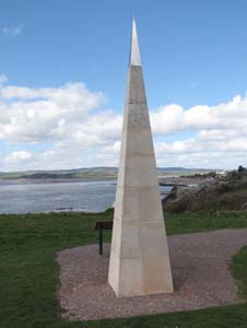
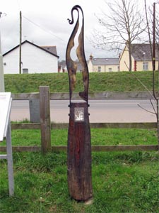
| Stone Type: | Geoneedle | |||||||||||||||||||||||||||||||||||||||||
| Grid Reference: | SY/021/796 | |||||||||||||||||||||||||||||||||||||||||
| Location: | On the cliff top at Orcombe Point, Exmouth. | |||||||||||||||||||||||||||||||||||||||||
| Inscription: | This Geoneedle was unveiled by His Royal Highness The Prince of Wales on 3rd October 2002 in celebration of the Dorset and East Devon Coast World Heritage Site. | |||||||||||||||||||||||||||||||||||||||||
| Notes: | The Geoneedle marks the eastern end of the Jurassic Coast World Heritage site. | |||||||||||||||||||||||||||||||||||||||||
|
||||||||||||||||||||||||||||||||||||||||||
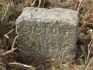
| Stone Type: | Boundary Stone | |||||||||||||||||||||||||||||||||||||||||
| Grid Reference: | SY/032/849 | |||||||||||||||||||||||||||||||||||||||||
| Location: | On the north side of the minor road from Exmouth to Yettington. | |||||||||||||||||||||||||||||||||||||||||
| Inscription: | Bicton Parish / Parish Boundary | |||||||||||||||||||||||||||||||||||||||||
|
||||||||||||||||||||||||||||||||||||||||||
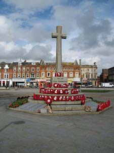
| Stone Type: | Exmouth War Memorial Cross | |||||||||||||||||||||||||||||||||||||||||
| Grid Reference: | SY/0006/8094 | |||||||||||||||||||||||||||||||||||||||||
| Location: | In the centre of the Strand at Exmouth | |||||||||||||||||||||||||||||||||||||||||
|
||||||||||||||||||||||||||||||||||||||||||
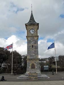
| Stone Type: | Exmouth Clock Tower | |||||||||||||||||||||||||||||||||||||||||
| Grid Reference: | SX/9998/8054 | |||||||||||||||||||||||||||||||||||||||||
| Location: | On the north side of the Esplanade, Exmouth, just to the west of it's junction with Alexandra Terrace. | |||||||||||||||||||||||||||||||||||||||||
| Notes: | Erected in 1897, in commemoration of Queen Victoria's Diamond Jubilee. | |||||||||||||||||||||||||||||||||||||||||
|
||||||||||||||||||||||||||||||||||||||||||
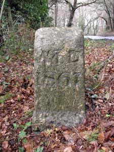
| Stone Type: | Boundary Stone | |||||||||||||||||||||||||||||||||||||||||
| Grid Reference: | SY/0222/8451 | |||||||||||||||||||||||||||||||||||||||||
| Location: | At the junction of Hulham Road, Exmouth, with the B3179 and B3180. | |||||||||||||||||||||||||||||||||||||||||
| Inscription: | W D 1867 (War Department) - (south face) / Lympstone C P 1996 (north face). | |||||||||||||||||||||||||||||||||||||||||
| Notes: | The stone also has an Ordnance Survey Benchmark on its south face. Its original use was to mark the boundary of the military area on Woodbury Common. | |||||||||||||||||||||||||||||||||||||||||
|
||||||||||||||||||||||||||||||||||||||||||
| Stone Type: | Milestone | |||||||||||||||||||||||||||||||||||||||||
| Grid Reference: | SY/0070/8140 | |||||||||||||||||||||||||||||||||||||||||
| Location: | On the disused railway track between Exmouth and Budleigh Salterton. | |||||||||||||||||||||||||||||||||||||||||
| Inscription: | Exmouth Seafront 3 / Exe Estuary 1 / Budleigh Salterton 5 / Sidmouth 15. | |||||||||||||||||||||||||||||||||||||||||
| Notes: | The milestone was sponsored by the Royal Bank of Scotland. | |||||||||||||||||||||||||||||||||||||||||
|
||||||||||||||||||||||||||||||||||||||||||
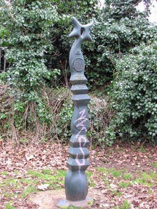
| Stone Type: | Marker Stone | |||||||||||||||||||||||||||||||||||||||||
| Grid Reference: | SY/9999/8152 | |||||||||||||||||||||||||||||||||||||||||
| Location: | On the Exmouth to Exeter cycle track. | |||||||||||||||||||||||||||||||||||||||||
| Notes: | This is one of a number of Markers along the Exe Valley Way. | |||||||||||||||||||||||||||||||||||||||||