|
Devon Marker Stones |

|
|||||||||||||||||||||
 |
 |
 |
 |
 |
 |
 |
 |
 |
 |
 |
 |
 |
 |
 |
 |
 |
|
||||||||||||||||||||||||||||||||||||||||||
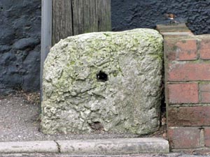
| District: | East Devon |
|
||||||||||||||||||||||||||||||||||||||||
| Parish: | Sidmouth | |||||||||||||||||||||||||||||||||||||||||
|
|
|||||||||||||||||||||||||||||||||||||||||
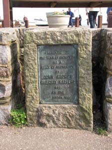
| Stone Type: | Park Marker Stone | |||||||||||||||||||||||||||||||||||||||||
| Grid Reference: | SY/128/873 | |||||||||||||||||||||||||||||||||||||||||
| Location: | In the park at the eastern end of the town centre. | |||||||||||||||||||||||||||||||||||||||||
| Inscription: | Presented to the town of Sidmouth as a place of Recreation by John George Galloway Radford Esq. on 26th March 1896. | |||||||||||||||||||||||||||||||||||||||||
|
||||||||||||||||||||||||||||||||||||||||||
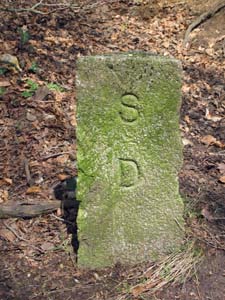
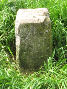
| Stone Type: | Boundary Stone | |||||||||||||||||||||||||||||||||||||||||
| Grid Reference: | ST/1122/9157 | |||||||||||||||||||||||||||||||||||||||||
| Location: | Beacon Hill, at the junction of the footpaths in the woods. | |||||||||||||||||||||||||||||||||||||||||
| Inscription: | S D / U C (Sidmouth Urban / District Council). | |||||||||||||||||||||||||||||||||||||||||
|
||||||||||||||||||||||||||||||||||||||||||
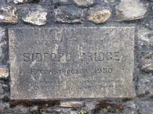
| Stone Type: | Bridge Marker Stone | |||||||||||||||||||||||||||||||||||||||||
| Grid Reference: | SY/1373/8996 | |||||||||||||||||||||||||||||||||||||||||
| Location: | Built into the parapet of the bridge over the River Sid at Sidford. | |||||||||||||||||||||||||||||||||||||||||
| Inscription: | County of Devon / Sidford Bridge / Reconstructed 1930. | |||||||||||||||||||||||||||||||||||||||||
|
||||||||||||||||||||||||||||||||||||||||||
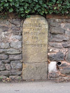
| Stone Type: | Milestone | |||||||||||||||||||||||||||||||||||||||||
| Grid Reference: | SY/1232/8748 | |||||||||||||||||||||||||||||||||||||||||
| Location: | Set against the wall of the old Toll House in Station Road, Sidmouth. | |||||||||||||||||||||||||||||||||||||||||
| Inscription: | Ottery 6. | |||||||||||||||||||||||||||||||||||||||||
| Notes: | There is an Ordnance Survey Benchmark cut into the base of the stone. | |||||||||||||||||||||||||||||||||||||||||
|
||||||||||||||||||||||||||||||||||||||||||
| Stone Type: | Milestone | |||||||||||||||||||||||||||||||||||||||||
| Grid Reference: | SY/1091/8995 | |||||||||||||||||||||||||||||||||||||||||
| Location: | On the southern grass verge of the B3176 near the Bowd Inn. | |||||||||||||||||||||||||||||||||||||||||
| Inscription: | Ottery 4 / Sidmouth 2; | |||||||||||||||||||||||||||||||||||||||||
|
||||||||||||||||||||||||||||||||||||||||||
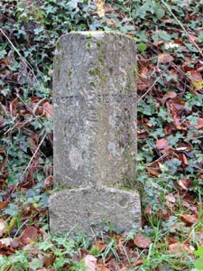
| Stone Type: | Milestone | |||||||||||||||||||||||||||||||||||||||||
| Grid Reference: | ST/1200/8969 | |||||||||||||||||||||||||||||||||||||||||
| Location: | Set back in the hedge of the A3052, 60 metres to the west of the junction with Core Hill Road. | |||||||||||||||||||||||||||||||||||||||||
| Inscription: | Exeter 13; | |||||||||||||||||||||||||||||||||||||||||
| Notes: | The milestone once had a metal plate fixed to it but this has now disappeared. There is an Ordnance Survey benchmark near the top of the stone. | |||||||||||||||||||||||||||||||||||||||||
|
||||||||||||||||||||||||||||||||||||||||||
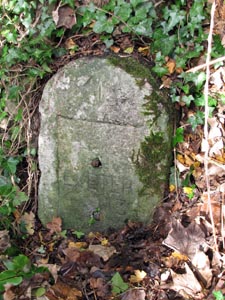
| Stone Type: | Milestone | |||||||||||||||||||||||||||||||||||||||||
| Grid Reference: | SY/1357/9001 | |||||||||||||||||||||||||||||||||||||||||
| Location: | On the north pavement of the A3052, outside Milestone Cottage, Sidford. | |||||||||||||||||||||||||||||||||||||||||
| Inscription: | There is no inscription on the stone. | |||||||||||||||||||||||||||||||||||||||||
| Notes: | The milestone once had a metal plate fixed to it but this has now disappeared. | |||||||||||||||||||||||||||||||||||||||||
|
||||||||||||||||||||||||||||||||||||||||||
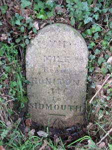
| Stone Type: | Milestone | |||||||||||||||||||||||||||||||||||||||||
| Grid Reference: | ST/1345/9046 | |||||||||||||||||||||||||||||||||||||||||
| Location: | Set low into the hedge on the western verge of the A375, near the junction with Ottery Lane. | |||||||||||||||||||||||||||||||||||||||||
| Inscription: | VII Miles From Honiton / II To Sidmouth. | |||||||||||||||||||||||||||||||||||||||||
| Notes: | There is an Ordnance Survey benchmark low down on the stone. | |||||||||||||||||||||||||||||||||||||||||
|
||||||||||||||||||||||||||||||||||||||||||
| Stone Type: | Cemetery Cross | |||||||||||||||||||||||||||||||||||||||||
| Grid Reference: | SY/1405/9108 | |||||||||||||||||||||||||||||||||||||||||
| Location: | At the southern end of the Sidbury Cemetery. | |||||||||||||||||||||||||||||||||||||||||
|
||||||||||||||||||||||||||||||||||||||||||
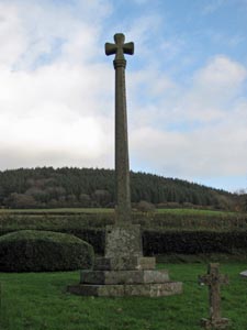
| Stone Type: | Village Cross | |||||||||||||||||||||||||||||||||||||||||
| Grid Reference: | ST/1378/9162 | |||||||||||||||||||||||||||||||||||||||||
| Location: | At a road junction on the west side of the A375 in Sidbury. | |||||||||||||||||||||||||||||||||||||||||
| Notes: | The cross serves as the Village War Memorial. | |||||||||||||||||||||||||||||||||||||||||
|
||||||||||||||||||||||||||||||||||||||||||
| Stone Type: | Milestone | |||||||||||||||||||||||||||||||||||||||||
| Grid Reference: | SY/1401/9189 | |||||||||||||||||||||||||||||||||||||||||
| Location: | Set into the roadside wall of the A375, 50 metres to the north of the school entrance. | |||||||||||||||||||||||||||||||||||||||||
| Inscription: | VI Miles From Honiton / III Sidmouth. | |||||||||||||||||||||||||||||||||||||||||
|
||||||||||||||||||||||||||||||||||||||||||
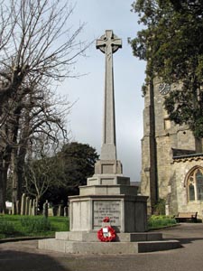
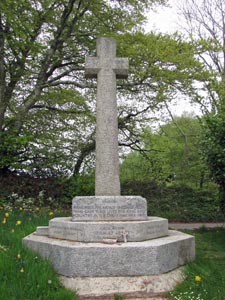
| Stone Type: | Sidmouth Churchyard Cross | |||||||||||||||||||||||||||||||||||||||||
| Grid Reference: | SY/1255/8734 | |||||||||||||||||||||||||||||||||||||||||
| Location: | In the south east corner of the Churchyard | |||||||||||||||||||||||||||||||||||||||||
| Inscription: | To the Glory of God and in Memory of the Men of Sidmouth who Fell in the Great War 1914 - 1918 | |||||||||||||||||||||||||||||||||||||||||
| Notes: | The cross serves as the Town War Memorial | |||||||||||||||||||||||||||||||||||||||||
|
||||||||||||||||||||||||||||||||||||||||||
| Stone Type: | Marker Stone | |||||||||||||||||||||||||||||||||||||||||
| Grid Reference: | SY/1382/8764 | |||||||||||||||||||||||||||||||||||||||||
| Location: | On the South West Coast Path at Salcombe Hill | |||||||||||||||||||||||||||||||||||||||||
| Inscription: | South Combe Farm including the summit of Salcombe Hill is dedicated by the Owner as a Permanent Open Space / Vaughan Cornish A.D. 1937. | |||||||||||||||||||||||||||||||||||||||||
|
||||||||||||||||||||||||||||||||||||||||||
| Stone Type: | Boundary Stone | |||||||||||||||||||||||||||||||||||||||||
| Grid Reference: | SY/1381/8764 | |||||||||||||||||||||||||||||||||||||||||
| Location: | On the South West Coast Path at Salcombe Hill | |||||||||||||||||||||||||||||||||||||||||
| Inscription: | ↑ 1826 | |||||||||||||||||||||||||||||||||||||||||
| Notes: | The arrow on the stone denotes that it marked the boundary of Government land - possibly an Admiralty Telegraph Station. | |||||||||||||||||||||||||||||||||||||||||
|
||||||||||||||||||||||||||||||||||||||||||
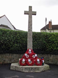
| Stone Type: | Salcombe Regis Village Cross | |||||||||||||||||||||||||||||||||||||||||
| Grid Reference: | SY/1452/8871 | |||||||||||||||||||||||||||||||||||||||||
| Location: | At the road junction, ¼ Mile south west of the Village. | |||||||||||||||||||||||||||||||||||||||||
| Inscription: | Remember the Men of Salcombe Regis who gave their lives for King and Country in the Great War 1914 - 1918. | |||||||||||||||||||||||||||||||||||||||||
| Notes: | The cross serves as the Village War Memorial | |||||||||||||||||||||||||||||||||||||||||
|
||||||||||||||||||||||||||||||||||||||||||
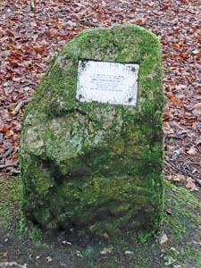
| Stone Type: | Marker Stone | |||||||||||||||||||||||||||||||||||||||||
| Grid Reference: | SY/117/907 | |||||||||||||||||||||||||||||||||||||||||
| Location: | At the junction of tracks on the edge of the woods on Core Hill. | |||||||||||||||||||||||||||||||||||||||||
| Inscription: | This area of Core Hill Wood is dedicated to the memory of Derek Marks (1934 - 1997) who served as a trustee of the Woodland Trust from 1988 - 1997. | |||||||||||||||||||||||||||||||||||||||||
| Notes: | ||||||||||||||||||||||||||||||||||||||||||
|
||||||||||||||||||||||||||||||||||||||||||
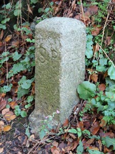
| Stone Type: | Boundary Stone | |||||||||||||||||||||||||||||||||||||||||
| Grid Reference: | SY/10987/87214 | |||||||||||||||||||||||||||||||||||||||||
| Location: | Opposite the Mutters Moor Car Park entrance - Peak Hill | |||||||||||||||||||||||||||||||||||||||||
| Inscription: | S P (Sidmouth Parish) | |||||||||||||||||||||||||||||||||||||||||
| Notes: | The stone also has an O.S. Benchmark | |||||||||||||||||||||||||||||||||||||||||