|
Devon Marker Stones |

|
|||||||||||||||||||||
 |
 |
 |
 |
 |
 |
 |
 |
|
|||||||||||||||||||||||||||||||||||||||||
| District: | Exeter |
|
|||||||||||||||||||||||||||||||||||||||
| Parish: | Topsham | ||||||||||||||||||||||||||||||||||||||||
|
|||||||||||||||||||||||||||||||||||||||||
|
|||||||||||||||||||||||||||||||||||||||||
| Stone Type: | Boundary Stone | ||||||||||||||||||||||||||||||||||||||||
| Grid Reference: | SX/9707/8822 | ||||||||||||||||||||||||||||||||||||||||
| Location: | On the north side of the road and at the eastern end of the bridge over the River Clyst, about 1 metre from the lamppost. | ||||||||||||||||||||||||||||||||||||||||
| Inscription: | Topsham P / St Georges Clyst P. | ||||||||||||||||||||||||||||||||||||||||
|
|||||||||||||||||||||||||||||||||||||||||
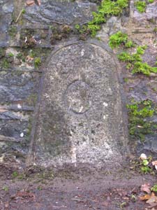
| Stone Type: | Boundary Stone | ||||||||||||||||||||||||||||||||||||||||
| Grid Reference: | SX/9695/8821 | ||||||||||||||||||||||||||||||||||||||||
| Location: | Built into the retaining wall on the south side of the hill leading down from Topsham to the bridge over the River Clyst, about 7 metres from the lamppost. | ||||||||||||||||||||||||||||||||||||||||
| Inscription: | C - (County Bridge Stone - see note on Home Page) | ||||||||||||||||||||||||||||||||||||||||
|
|||||||||||||||||||||||||||||||||||||||||
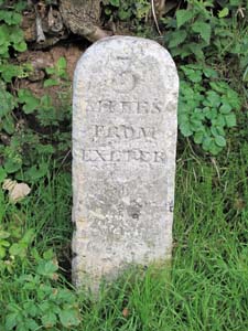
| Stone Type: | Milestone | ||||||||||||||||||||||||||||||||||||||||
| Grid Reference: | SX/9601/8886 | ||||||||||||||||||||||||||||||||||||||||
| Location: | On the north east side of Topsham Road as it enters the town and almost opposite the Bus Stop. | ||||||||||||||||||||||||||||||||||||||||
| Inscription: | 3 Miles From Exeter | ||||||||||||||||||||||||||||||||||||||||
|
|||||||||||||||||||||||||||||||||||||||||
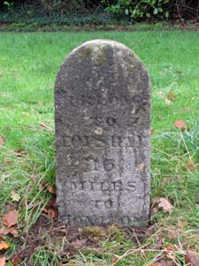
| Stone Type: | Milestone | ||||||||||||||||||||||||||||||||||||||||
| Grid Reference: | SX/9648/8910 | ||||||||||||||||||||||||||||||||||||||||
| Location: | On the grass verge, on the east side of Clyst Road at the junction with Highfield. | ||||||||||||||||||||||||||||||||||||||||
| Inscription: | 5½ Furlongs to Topsham / 16 Miles To Honiton | ||||||||||||||||||||||||||||||||||||||||
|
|||||||||||||||||||||||||||||||||||||||||
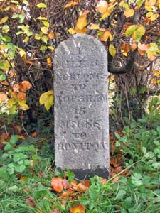
| Stone Type: | Milestone | ||||||||||||||||||||||||||||||||||||||||
| Grid Reference: | SX/9662/9067 | ||||||||||||||||||||||||||||||||||||||||
| Location: | On the east side of Clyst Road, about 180 metres south of the Old Rydon Lane junction. | ||||||||||||||||||||||||||||||||||||||||
| Inscription: | 1 Mile 5½ Furlongs to Topsham / 15 Miles To Honiton | ||||||||||||||||||||||||||||||||||||||||
|
|||||||||||||||||||||||||||||||||||||||||
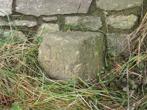
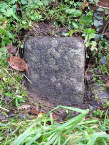
| Stone Type: | Boundary Stone | ||||||||||||||||||||||||||||||||||||||||
| Grid Reference: | SX/967/908 | ||||||||||||||||||||||||||||||||||||||||
| Location: | On the east side of Clyst Road, beside the signpost at the Old Rydon Lane Junction. | ||||||||||||||||||||||||||||||||||||||||
| Notes: | The inscription is now illegible, but it is understood that this stone marks the boundary between the parishes of Topsham and Heavitree. | ||||||||||||||||||||||||||||||||||||||||
|
|||||||||||||||||||||||||||||||||||||||||
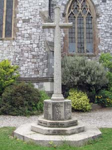
| Stone Type: | Churchyard Cross | ||||||||||||||||||||||||||||||||||||||||
| Grid Reference: | SX/9656/8804 | ||||||||||||||||||||||||||||||||||||||||
| Location: | Just inside the entrance to the churchyard from Topsham High Street. | ||||||||||||||||||||||||||||||||||||||||
| Notes: | The cross serves as the local war memorial. | ||||||||||||||||||||||||||||||||||||||||
|
|||||||||||||||||||||||||||||||||||||||||
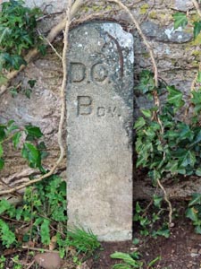
| Stone Type: | Boundary Stone | ||||||||||||||||||||||||||||||||||||||||
| Grid Reference: | SX/9700/8723 | ||||||||||||||||||||||||||||||||||||||||
| Location: | At the end of the Goat Walk, where the path meets the road. | ||||||||||||||||||||||||||||||||||||||||
| Inscription: | D. O. ? Bdy. | ||||||||||||||||||||||||||||||||||||||||
| Notes: | Although one letter has broken away, it is thought to mark a Department Of Environment Boundary. | ||||||||||||||||||||||||||||||||||||||||