| |
|
|
|
|
|
|
|
|
|
|
|
|
| |
|
|
|
|
|
|
|
|
|
|
|
|
|
|
|
|
|
|
|
|
District: |
Mid Devon |
|
|
|
|
|
|
|
|
|
|
|
 |
|
| |
|
|
|
|
|
|
|
|
|
|
|
|
|
|
|
|
|
|
Parish: |
Halberton |
 |
 |
 |
|
|
|
|
| |
|
|
|
|
|
|
|
|
|
|
|
|
|
|
|
|
|
|
|
| |
|
|
|
|
|
|
|
|
|
|
|
|
|
|
|
|
|
|
|
| |
|
|
|
|
|
|
|
|
|
|
|
|
|
|
|
|
|
|
|
| Page
Contents: |
|
| |
1 Boundary Stone |
| |
1 Marker Stone |
| |
5 Milestones |
| |
|
| |
|
| |
|
|
|
|
|
|
|
|
|
|
|
|
|
|
|
|
|
|
| |
|
|
|
|
|
|
|
|
|
|
|
|
|
| |
|
|
|
|
|
|
|
|
|
|
|
|
|
| |
|
|
|
|
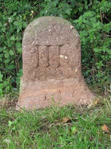
Stone Type: |
Grand Western Canal Milestone |
| |
|
|
|
|
Grid Reference: |
SS/9985/1315 |
| |
|
|
|
|
Location: |
On the east bank of the canal, back against the field hedge. |
| |
|
|
|
|
Inscription: |
III (3 Miles from the Tiverton end of the canal). |
| |
|
|
|
|
|
|
|
|
|
| |
|
|
|
|
|
|
|
|
|
|
|
|
|
|
|
|
| |
|
|
|
|
|
|
|
|
|
|
|
|
|
|
|
|
|
|
|
|
|
|
|
|
|
|
|
|
|
|
|
|
| |
|
|
|
|
|
|
|
|
|
|
|
|
|
| |
|
|
|
|
|
|
|
|
|
|
|
|
|
|
|
|
|
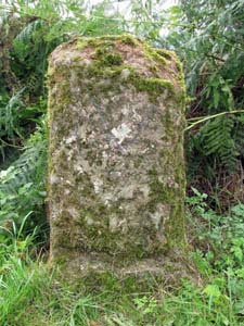
Stone Type: |
Grand Western Canal Milestone |
|
|
|
|
|
|
|
|
|
Grid Reference: |
ST/0006/1315 |
|
|
|
|
|
|
|
|
|
Location: |
On the south bank of the canal, back against the field hedge. |
|
|
|
|
|
|
|
|
|
Inscription: |
IV (4 Miles from the Tiverton end of the canal). |
|
|
|
|
|
|
|
|
|
|
|
|
|
|
|
|
|
|
|
| |
|
|
|
|
|
|
|
|
|
|
|
|
|
|
|
|
| |
|
|
|
|
|
|
|
|
|
|
|
|
|
|
|
|
| |
|
|
|
|
|
|
|
|
|
|
|
|
|
|
| |
|
|
|
|
|
|
|
|
|
|
|
|
|
| |
|
|
|
|
|
|
|
|
|
|
|
|
|
|
|
|
| |
|
|
|
|
|
|
|
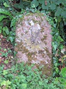
Stone Type: |
Grand Western Canal Milestone |
| |
|
|
|
|
|
|
|
Grid Reference: |
ST/0150/1313 |
| |
|
|
|
|
|
|
|
Location: |
On the south bank of the canal, back against the field hedge. |
| |
|
|
|
|
|
|
|
Inscription: |
V (5 Miles from the Tiverton end of the canal). |
| |
|
|
|
|
|
|
|
|
|
| |
|
|
|
|
|
|
|
|
|
|
|
|
|
|
|
|
| |
|
|
|
|
|
|
|
|
|
|
|
|
|
|
|
|
|
|
|
|
|
|
|
|
|
|
|
|
|
|
|
|
| |
|
|
|
|
|
|
|
|
|
|
|
|
|
| |
|
|
|
|
|
|
|
|
|
|
|
|
|
|
|
|
|
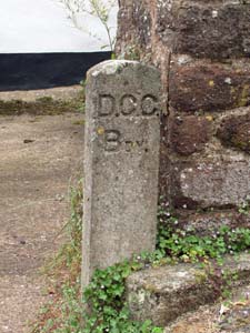
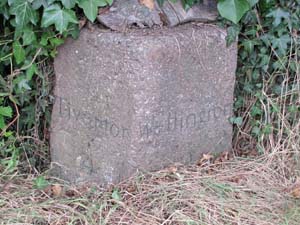
Stone Type: |
Boundary Stone |
|
|
|
|
|
|
|
|
|
Grid Reference: |
ST/0060/1288 |
|
|
|
|
|
|
|
|
|
Location: |
At the end of a parking space and beside the wall of a house next to the
path leading to Halberton Church. |
|
|
|
|
|
|
|
|
|
Inscription: |
D.C.C. Bdy. |
|
|
|
|
|
|
|
|
| Notes: |
The origin of this stone is not known to me, but it is assumed that the
Inscription represents 'Devon County Council Boundary', perhaps to show the
boundary between the grounds of the house and the public highway. |
|
|
|
|
|
|
|
|
| |
|
|
|
|
|
|
|
|
|
|
|
|
|
|
|
|
| |
|
|
|
|
|
|
|
|
|
|
|
|
|
|
|
|
| |
|
|
|
|
|
|
|
|
|
|
|
|
|
|
| |
|
|
|
|
|
|
|
|
|
|
|
|
|
| |
|
|
|
|
|
|
|
|
|
|
|
|
|
|
|
|
| |
|
|
|
|
|
|
|
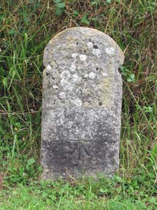
Stone Type: |
Milestone |
| |
|
|
|
|
|
|
|
Grid Reference: |
ST/0040/1295 |
| |
|
|
|
|
|
|
|
Location: |
At the junction of the road running north into Halberton, with the road
leading into Lower Town. The stone is set back against the hedge on the west
side of the road. |
| |
|
|
|
|
|
|
|
Notes: |
The inscription has now become illegible, but the stone clearly shows an
Ordnance Survey Benchmark low down on its roadside face. |
| |
|
|
|
|
|
|
|
|
|
| |
|
|
|
|
|
|
|
|
|
|
|
|
|
|
|
|
| |
|
|
|
|
|
|
|
|
|
|
|
|
|
|
|
|
|
|
|
|
|
|
|
|
|
|
|
|
|
|
|
| |
|
|
|
|
|
|
|
|
|
|
|
|
|
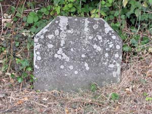
Stone Type: |
Memorial Marker Stone |
|
|
|
|
|
|
|
|
Grid Reference: |
ST/0044/1293 |
|
|
|
|
|
|
|
|
Location: |
At the junction of the road running north into Halberton, with the road
leading into Lower Town. The stone is beside the bench on the east side of
the road. |
|
|
|
|
|
|
|
| Notes: |
Although the inscription has now become illegible, the stone was placed here
to record the planting of a tree to mark the Diamond Jubilee of Queen
Victoria. The tree has since been felled and not replaced. |
|
|
|
|
|
|
|
| |
|
|
|
|
|
| |
|
|
|
|
|
|
|
|
|
|
|
| |
|
|
Stone Type: |
Milestone |
| |
|
|
|
|
|
|
Grid Reference: |
ST/0167/1317 |
| |
|
|
|
|
|
|
Location: |
On the west side of the road, about 100 metres north of the Rock Canal
Bridge and to the right of the entrance gate to a private house. |
| |
|
|
|
|
|
|
Inscription: |
Tiverton 4 / Wellington 10. |
| |
|
|
|
|
|
|
|
|
| |
|
|
|
|
|
|
|
|
|
|
|
|
|
|
|
| |
|
|
|
|
|
|
|
|
|
|
|
|
|
|
|
|
|
|
|
|
|
|
|
|
|
|
|
|
|
|
|
|
|
|
|
| |
|
|
|
|
|
|
|
|
|
|
|
|
|
|
|
|
|
|
|
|
|
|
|
|
|
|
|
|
|
|
|
|
|
|
|
|
|
|
|