| |
|
|
|
|
|
|
|
|
|
|
|
|
| |
|
|
|
|
|
|
|
|
|
|
|
|
|
|
|
|
|
|
|
|
District: |
North
Devon |
|
|
|
|
|
|
|
|
|
|
|
 |
|
| |
|
|
|
|
|
|
|
|
|
|
|
|
|
|
|
|
|
|
Parish: |
Barnstaple |
 |
 |
 |
|
|
|
|
| |
|
|
|
|
|
|
|
|
|
|
|
|
|
|
|
|
|
|
|
| |
|
|
|
|
|
|
|
|
|
|
|
|
|
|
|
|
|
|
|
| |
|
|
|
|
|
|
|
|
|
|
|
|
|
|
|
|
|
|
|
| Page
Contents: |
|
| |
1 Cross |
| |
2 Marker Stones
|
| |
11 Milestones
|
| |
|
| |
|
| |
|
|
|
|
|
|
|
|
|
|
|
|
|
|
|
|
|
|
|
|
| |
|
|
|
|
|
|
|
|
|
|
|
|
|
|
|
|
| |
|
|
|
|
|
|
|
|
|
|
|
|
|
| |
|
|
|
|
|
|
|
|
|
|
|
|
| |
|
|
|
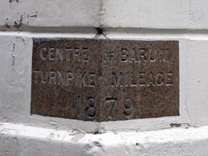
Stone Type: |
Milestone |
| |
|
|
|
Grid Reference: |
SS/5579/3324 |
| |
|
|
|
Location: |
Built
into the corner wall of the Guildhall on the Junction of High Street and
Butchers Row, Barnstaple. |
| |
|
|
|
|
|
|
Inscription: |
Centre
of Barum Turnpike Mileage 1879 |
|
|
|
|
|
|
|
Notes: |
It
was from this stone that all mileages of the Barnstaple Turnpikes were
measured. (See the note on Turnpike Trusts on the Home Page). |
|
|
|
|
|
|
|
|
|
|
|
|
|
|
|
| |
|
|
|
|
|
|
|
|
|
|
|
|
|
|
|
|
|
|
|
|
|
|
|
|
|
|
|
|
|
|
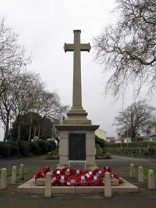
Stone Type: |
Town
Cross |
|
|
|
|
|
|
|
|
|
Grid Reference: |
SS/5614/3266 |
|
|
|
|
|
|
|
|
|
Location: |
At
the northern entrance to Rock Park, Barnstaple. |
|
|
|
|
|
|
|
|
| Notes: |
The
cross serves as the Town's War Memorial. |
|
|
|
|
|
|
|
|
|
|
|
|
|
|
|
|
|
|
|
|
|
|
|
|
|
|
|
|
|
|
|
|
|
|
|
|
|
|
|
|
|
|
|
|
|
|
|
|
|
|
|
|
|
|
|
|
|
|
|
|
|
|
|
|
|
|
|
|
|
|
|
|
|
|
|
|
|
|
|
|
|
|
|
|
|
|
|
|
|
|
|
|
|
|
|
|
|
|
|
|
|
|
|
|
|
|
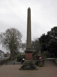
Stone Type: |
Town
Obelisk |
|
|
|
|
|
|
|
|
Grid Reference: |
SS/5609/3271 |
|
|
|
|
|
|
|
|
Location: |
At
the northern entrance to Rock Park, Barnstaple. |
|
|
|
|
|
|
|
|
Notes: |
The
obelisk was erected to commemorate the opening of Rock Park in 1879. |
|
|
|
|
|
|
|
|
|
|
|
|
|
|
|
|
|
|
|
|
|
|
|
|
|
|
|
|
|
|
|
|
|
|
|
|
|
|
|
|
|
|
|
|
|
|
|
|
|
|
|
|
|
|
|
|
|
|
|
|
|
|
|
|
|
|
|
|
|
|
|
|
|
|
|
|
|
|
|
|
|
|
|
|
|
|
|
|
|
|
|
|
Stone Type: |
Milestone |
|
|
|
|
|
|
|
|
|
Grid Reference: |
SS/5505/3430 |
|
|
|
|
|
|
|
|
|
Location: |
Just
a few metres north of the bridge over the Bradiford Water |
|
|
|
|
|
|
|
|
|
Inscription: |
1
Barum |
|
|
|
|
|
|
|
|
| Notes: |
There
is an Ordnance Survey Benchmark engraved into the top of the stone |
|
|
|
|
|
|
|
|
|
|
|
|
|
|
|
|
|
|
|
|
|
|
|
|
|
|
|
|
|
|
|
|
|
|
|
|
|
|
|
|
|
|
|
|
|
|
|
|
|
|
|
|
|
|
|
|
|
|
|
|
|
|
|
|
|
|
|
|
|
|
|
|
|
|
|
|
|
|
|
|
|
|
|
|
|
|
|
|
|
|
|
|
|
|
|
|
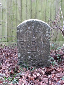
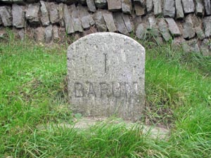
Stone Type: |
Milestone |
|
|
|
|
|
|
|
|
Grid Reference: |
SS/5611/3458 |
|
|
|
|
|
|
|
|
Location: |
Set
into the verge at the junction with Youings Drive |
|
|
|
|
|
|
|
|
Inscription: |
1
Barum |
|
|
|
|
|
|
|
|
Notes: |
There
is an Ordnance Survey Benchmark engraved into the face of the stone |
|
|
|
|
|
|
|
|
|
|
|
|
|
|
|
|
|
|
|
|
|
|
|
|
|
|
|
|
|
|
|
|
|
|
|
|
|
|
|
|
|
|
|
|
|
|
|
|
|
|
|
|
|
|
|
|
|
|
|
|
|
|
|
|
|
|
|
|
|
|
|
|
|
|
|
|
|
|
|
|
|
|
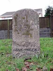
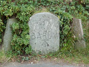
Stone Type: |
Milestone |
|
|
|
|
|
|
|
|
|
Grid Reference: |
SS/5735/3331 |
|
|
|
|
|
|
|
|
|
Location: |
On
the grass verge of Goodleigh Road, opposite the entrance to a new housing
estate |
|
|
|
|
|
|
|
|
|
Inscription: |
1
Barum |
|
|
|
|
|
|
|
|
|
|
|
|
|
|
|
|
|
|
|
|
|
|
|
|
|
|
|
|
|
|
|
|
|
|
|
|
|
|
|
|
|
|
|
|
|
|
|
|
|
|
|
|
|
|
|
|
|
|
|
|
|
|
|
|
|
|
|
|
|
|
|
|
|
|
|
|
|
|
|
|
|
|
|
|
|
|
|
|
|
|
|
|
|
|
|
|
|
|
|
|
|
|
|
|
|
|
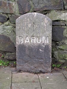
Stone Type: |
Milestone |
|
|
|
|
|
|
|
|
Grid Reference: |
SS/5687/3215 |
|
|
|
|
|
|
|
|
Location: |
On
the north side of Landkey Road, against the garden wall. |
|
|
|
|
|
|
|
|
Inscription: |
1
Barum |
|
|
|
|
|
|
|
|
Notes: |
There
is an Ordnance Survey Benchmark engraved into the face of the stone |
|
|
|
|
|
|
|
|
|
|
|
|
|
|
|
|
|
|
|
|
|
|
|
|
|
|
|
|
|
|
|
|
|
|
|
|
|
|
|
|
|
|
|
|
|
|
|
|
|
|
|
|
|
|
|
|
|
|
|
|
|
|
|
|
|
|
|
|
|
|
|
|
|
|
|
|
|
|
|
|
|
|
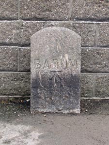
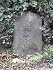
Stone Type: |
Milestone |
|
|
|
|
|
|
|
|
|
Grid Reference: |
SS/5665/3207 |
|
|
|
|
|
|
|
|
|
Location: |
On
the west side of South Street, against the stone wall. |
|
|
|
|
|
|
|
|
|
Inscription: |
1
Barum |
|
|
|
|
|
|
|
|
|
|
|
|
|
|
|
|
|
|
|
|
|
|
|
|
|
|
|
|
|
|
|
|
|
|
|
|
|
|
|
|
|
|
|
|
|
|
|
|
|
|
|
|
|
|
|
|
|
|
|
|
|
|
|
|
|
|
|
|
|
|
|
|
|
|
|
|
|
|
|
|
|
|
|
|
|
|
Stone Type: |
Milestone |
|
|
|
|
|
|
|
Grid Reference: |
SS/5478/3238 |
|
|
|
|
|
|
|
Location: |
On
the south verge of Grange Road, beside the Bus Stop |
|
|
|
|
|
|
|
Inscription: |
1
Barum |
|
|
|
|
|
|
|
|
|
|
|
|
|
|
|
|
|
|
|
|
|
|
|
|
|
|
|
|
|
|
|
|
|
|
|
|
|
|
|
|
|
|
|
|
|
|
|
|
|
|
|
|
|
|
|
|
Stone Type: |
Milestone |
|
|
|
|
|
|
|
|
Grid Reference: |
SS/5481/3238 |
|
|
|
|
|
|
|
|
Location: |
Set
into the base of the hedge, on the western side of Old Torrington Road. |
|
|
|
|
|
|
|
|
Inscription: |
1
Barum |
|
|
|
|
|
|
|
| Notes: |
There
is an Ordnance Survey Benchmark engraved into the face of the stone |
|
|
|
|
|
|
|
|
|
|
|
|
|
|
|
|
|
|
|
|
|
|
|
|
|
|
|
|
|
|
|
|
|
|
|
|
|
|
|
|
|
|
|
|
|
|
|
|
|
|
|
|
|
|
|
|
|
|
|
Stone Type: |
Milestone |
|
|
|
|
|
|
|
|
Grid Reference: |
SS/5403/3096 |
|
|
|
|
|
|
|
|
Location: |
In
the base of the hedge on the north western side of the B3232, 85 metres up
the hill from the Upcott Farm Lane Entrance |
|
|
|
|
|
|
|
|
Inscription: |
2
Barum |
|
|
|
|
|
|
|
|
|
|
|
|
|
|
|
|
|
|
|
|
|
|
|
|
|
|
|
|
|
|
|
|
|
|
|
|
|
|
|
|
|
|
|
|
|
|
|
|
|
|
|
|
|
|
|
|
|
|
|
|
|
|
|
|
|
|
|
|
|
|
|
|
|
|
|
|
|
|
|
|
|
|
|
|
|
|
|
|
|
|
|
|
Stone Type: |
Cycle
Path Milestone |
|
|
|
|
|
|
|
|
|
Grid Reference: |
SS/5569/3310 |
|
|
|
|
|
|
|
|
|
Location: |
On
the Tarka Trail at Barnstaple. |
|
|
|
|
|
|
|
|
|
Inscription: |
5½M
Braunton / 15M Ilfracombe / Bideford 9M |
|
|
|
|
|
|
|
|
|
Notes: |
The
milestone was sponsored by the Royal Bank of Scotland. |
|
|
|
|
|
|
|
|
|
|
|
|
|
|
|
|
|
|
|
|
|
|
|
|
|
|
|
|
|
|
|
|
|
|
|
|
|
|
|
|
|
|
|
|
|
|
|
|
|
|
|
|
|
|
|
|
|
|
|
|
|
|
|
|
|
|
|
|
|
|
|
|
|
|
|
|
|
|
|
|
|
|
|
|
|
|
|
|
|
|
|
|
|
|
|
|
Stone Type: |
Cycle
Path Milestone |
|
|
|
|
|
|
|
|
Grid Reference: |
SS/5522/3281 |
|
|
|
|
|
|
|
|
Location: |
On
the Tarka Trail at Barnstaple. |
|
|
|
|
|
|
|
|
Inscription: |
Dartmoor
and the Atlantic / Bideford / Exmoor and Up Yonder. |
|
|
|
|
|
|
|
|
Notes: |
The
milestone was sponsored by the Royal Bank of Scotland. |
|
|
|
|
|
|
|
|
|
|
|
|
|
|
|
|
|
|
|
|
|
|
|
|
|
|
|
|
|
|
|
|
|
|
|
|
|
|
|
|
|
|
|
|
|
|
|
|
|
|
|
|
|
|
|
|
|
|
|
|
|
|
|
|
|
|
|
|
|
|
|
|
|
|
|
|
|
|
|
|
|
|
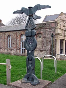
Stone Type: |
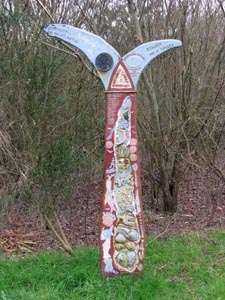
Bypass
Marker Stone |
|
|
|
|
|
|
|
|
|
Grid Reference: |
SS/5520/3289 |
|
|
|
|
|
|
|
|
|
Location: |
On
the Tarka Trail, where it joins the Western Bypass. |
|
|
|
|
|
|
|
|
|
Inscription: |
Barnstaple
Western Bypass opened by Cllr Brian Greenslade |
|
|
|
|
|
|
|
|
|
|
|
|
|
|
|
|
|
|
|
|
|
|
|
|
|
|
|
|
|
|
|
|
|
|
|
|
|
|
|
|
|
|
|
|
|
|
|
|
|
|
|
|
|
|
|
|
|
|
|
|
|
|
|
|
|
|
|
|
|
|
|
|
|
|
|
|
|
|
|
|
|
|
|
|
|
|
|
|
|
|
|
|
|
|
|
|
|
|
|
|
|
|
|
|
|
|
| |
|
|
|
|
|
|
|
|
|
|
|
|
|
|
|
|
|
|
|
|
|
|
|
|
|
|
|
|
|
|
|
|
|
|
|
|
|
|
|