| |
|
|
|
|
|
|
|
|
|
|
|
|
| |
|
|
|
|
|
|
|
|
|
|
|
|
|
|
|
|
|
|
|
|
District: |
South
Hams |
|
|
|
|
|
|
|
|
|
|
|
 |
|
| |
|
|
|
|
|
|
|
|
|
|
|
|
|
|
|
|
|
|
Parish: |
Ivybridge |
 |
 |
 |
|
|
|
|
| |
|
|
|
|
|
|
|
|
|
|
|
|
|
|
|
|
|
|
|
| |
|
|
|
|
|
|
|
|
|
|
|
|
|
|
|
|
|
|
|
| |
|
|
|
|
|
|
|
|
|
|
|
|
|
|
|
|
|
|
|
| Page
Contents: |
|
| |
10 Boundary Stones |
| |
2 Crosses |
| |
3 Marker Stones |
| |
1 Milestone |
| |
|
| |
|
|
|
|
|
|
|
|
|
|
|
|
|
|
|
|
|
|
|
|
| |
|
|
|
|
|
|
|
|
|
|
|
|
|
|
|
|
| |
|
|
|
|
|
|
|
|
|
|
|
|
|
| |
|
|
|
|
|
|
|
|
|
|
|
|
| |
|
|
|
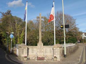
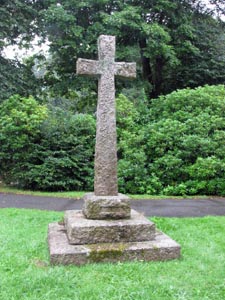
Stone Type: |
Town
Cross |
| |
|
|
|
Grid Reference: |
SX/6359/5623 |
| |
|
|
|
Location: |
On
the corner of Fore Street and Erme Road, adjacent to the bridge over the
River Erme. |
| |
|
|
|
|
|
|
Inscription: |
In
Honour of the Men of Ivybridge who made the Supreme Sacrifice for their
Country in the Great War 1914 - 1918. |
| |
|
|
|
|
|
|
|
|
|
|
|
|
|
Notes: |
The
cross serves as a memorial for World Wars I & II |
| |
|
|
|
|
|
|
|
|
|
|
|
|
| |
|
|
|
|
|
|
|
|
|
|
|
|
|
|
|
|
|
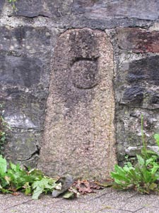
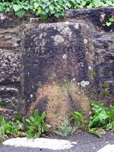
Stone Type: |
Boundary
Stone |
|
|
|
|
|
|
|
|
|
Grid Reference: |
SX/6364/5627 |
|
|
|
|
|
|
|
|
|
Location: |
Built
into the Car Park wall, opposite Costly Street |
|
|
|
|
|
|
|
|
|
Inscription: |
C
- (County Bridge Stone - see note on Home Page) |
|
|
|
|
|
|
|
|
| |
|
|
|
|
|
|
|
|
|
| |
|
|
|
|
|
|
|
|
|
|
|
|
|
|
|
|
| |
|
|
|
|
|
|
|
|
|
|
|
|
|
|
| |
|
|
|
|
|
|
|
|
|
|
|
|
|
| |
|
|
|
|
|
|
|
|
|
|
|
|
|
| |
|
|
|
|
|
|
|
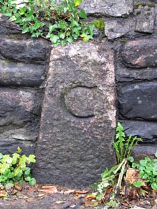
Stone Type: |
Boundary
Stone |
| |
|
|
|
|
|
|
|
Grid Reference: |
SX/6360/5627 |
| |
|
|
|
|
|
|
|
Location: |
Erme
Road, built into the riverside wall, 30 metres north of Highland Street. |
| |
|
|
|
|
|
|
|
Inscription: |
C
- (County Bridge Stone - see note on Home Page) |
| |
|
|
|
|
|
|
|
|
|
| |
|
|
|
|
|
|
|
|
|
|
|
|
|
|
|
|
| |
|
|
|
|
|
|
|
|
|
|
|
|
|
|
|
|
|
|
|
|
|
|
|
|
|
|
|
|
|
|
|
|
| |
|
|
|
|
|
|
|
|
|
|
|
|
|
| |
|
|
|
|
|
|
|
|
|
|
|
|
|
|
|
|
|
Stone Type: |
Boundary
Stone |
|
|
|
|
|
|
|
|
|
Grid Reference: |
SX/6360/5636 |
|
|
|
|
|
|
|
|
|
Location: |
Erme
Road, built into the end of the southern parapet of the bridge |
|
|
|
|
|
|
|
|
|
Inscription: |
Ermington |
|
|
|
|
|
|
|
|
| |
|
|
|
|
|
|
|
|
|
| |
|
|
|
|
|
|
|
|
|
|
|
|
|
|
|
|
| |
|
|
|
|
|
|
|
|
|
|
|
|
|
|
|
|
| |
|
|
|
|
|
|
|
|
|
|
|
|
|
|
| |
|
|
|
|
|
|
|
|
|
|
|
|
|
| |
|
|
|
|
|
|
|
|
|
|
|
|
|
|
|
|
| |
|
|
|
|
|
|
|
Stone Type: |
Boundary
Stone |
| |
|
|
|
|
|
|
|
Grid Reference: |
SX/6362/5635 |
| |
|
|
|
|
|
|
|
Location: |
Harford
Road, built into the end of the southern parapet of the bridge |
| |
|
|
|
|
|
|
|
Inscription: |
Ugborough |
| |
|
|
|
|
|
|
|
|
|
| |
|
|
|
|
|
|
|
|
|
|
|
|
|
|
|
|
| |
|
|
|
|
|
|
|
|
|
|
|
|
|
|
|
|
|
|
|
|
|
|
|
|
|
|
|
|
|
|
|
|
| |
|
|
|
|
|
|
|
|
|
|
|
|
|
| |
|
|
|
|
|
|
|
|
|
|
|
|
|
|
|
|
|
Stone Type: |
Churchyard
Cross |
|
|
|
|
|
|
|
|
|
Grid Reference: |
SX/6350/5636 |
|
|
|
|
|
|
|
|
|
Location: |
Beside
the main path leading to the entrance of the Parish Church. |
|
|
|
|
|
|
|
|
|
Inscription: |
1914
- 1918 |
|
|
|
|
|
|
|
|
| Notes: |
World
War I Memorial, with a plaque for Capt. R.S. Hawker who fell in Palestine
in 1917. |
|
|
|
|
|
|
|
|
|
|
|
|
|
|
|
|
|
|
| |
|
|
|
|
|
|
|
|
|
|
|
|
|
|
|
|
| |
|
|
|
|
|
|
|
|
|
|
|
|
|
|
| |
|
|
|
|
|
|
|
|
|
|
|
|
|
| |
|
|
|
|
|
|
|
|
|
|
|
|
|
|
|
|
| |
|
|
|
|
|
|
|
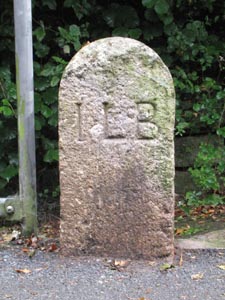
Stone Type: |
Boundary
Stone |
| |
|
|
|
|
|
|
|
Grid Reference: |
SX/6268/5665 |
| |
|
|
|
|
|
|
|
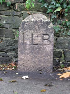
Location: |
On
the south west side of Cleeve Road, at the end of the metal railings. |
| |
|
|
|
|
|
|
|
Inscription: |
I
L B (Ivybridge Local Board) |
| |
|
|
|
|
|
|
|
|
|
| |
|
|
|
|
|
|
|
|
|
|
|
|
|
|
|
|
| |
|
|
|
|
|
|
|
|
|
|
|
|
|
|
|
|
|
|
|
|
|
|
|
|
|
|
|
|
|
|
|
|
| |
|
|
|
|
|
|
|
|
|
|
|
|
|
| |
|
|
|
|
|
|
|
|
|
|
|
|
|
|
|
|
|
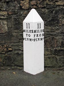
Stone Type: |
Milestone |
|
|
|
|
|
|
|
|
|
Grid Reference: |
SX/6414/5632 |
|
|
|
|
|
|
|
|
|
Location: |
On
the south side of Exeter Road, beside the entrance to 'Torre Hill' |
|
|
|
|
|
|
|
|
|
Inscription: |
11
Miles to Plymo / 11 Miles From Plymo (Plymouth) |
|
|
|
|
|
|
|
|
| |
|
|
|
|
|
|
|
|
|
| |
|
|
|
|
|
|
|
|
|
|
|
|
|
|
|
|
| |
|
|
|
|
|
|
|
|
|
|
|
|
|
|
|
|
| |
|
|
|
|
|
|
|
|
|
|
|
|
|
|
| |
|
|
|
|
|
|
|
|
|
|
|
|
|
|
|
|
|
|
|
|
|
|
|
|
|
|
|
|
|
|
|
|
|
|
|
|
|
|
Stone Type: |
Boundary
Stone |
|
|
|
|
|
|
|
|
Grid Reference: |
SX/6425/5628 |
|
|
|
|
|
|
|
|
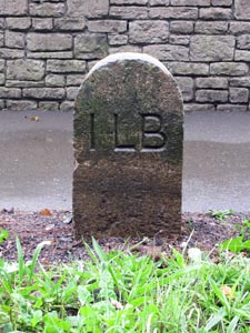
Location: |
On
the south side of Exeter Road, 70 metres east of the pedestrian traffic
lights. |
|
|
|
|
|
|
|
|
Inscription: |
I
L B (Ivybridge Local Board) |
|
|
|
|
|
|
|
|
|
|
|
|
|
|
|
|
|
|
|
|
|
|
|
|
|
|
|
| |
|
|
|
|
|
|
|
|
|
|
|
|
|
|
|
|
|
|
|
|
|
|
|
|
|
|
|
|
|
|
|
|
| |
|
|
|
|
|
|
|
|
|
|
|
|
|
| |
|
|
|
|
|
|
|
|
|
|
|
|
|
|
|
|
|
Stone Type: |
Boundary
Stone |
|
|
|
|
|
|
|
|
|
Grid Reference: |
SX/6432/5626 |
|
|
|
|
|
|
|
|
|
Location: |
On
the south side of Exeter Road, 60 metres west of Rue St Pierre |
|
|
|
|
|
|
|
|
|
Inscription: |
I
L B (Ivybridge Local Board) |
|
|
|
|
|
|
|
|
| |
|
|
|
|
|
|
|
|
|
| |
|
|
|
|
|
|
|
|
|
|
|
|
|
|
|
|
| |
|
|
|
|
|
|
|
|
|
|
|
|
|
|
|
|
| |
|
|
|
|
|
|
|
|
|
|
|
|
|
|
| |
|
|
|
|
|
|
|
|
|
|
|
|
|
|
|
|
|
|
|
|
|
|
|
|
|
|
|
|
|
|
|
|
|
|
|
|
|
|
Stone Type: |
Boundary
Stone |
|
|
|
|
|
|
|
|
Grid Reference: |
SX/6002/5576 |
|
|
|
|
|
|
|
|
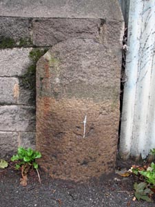
Location: |
On
the north side of Plymouth Road, Lee Mill, against the bridge parapet to
the east of the River Yealm. |
|
|
|
|
|
|
|
|
|
|
|
|
|
|
|
|
|
Inscription: |
Ermington |
|
|
|
|
|
|
|
|
|
|
|
|
|
|
|
|
|
| |
|
|
|
|
|
|
|
|
|
|
|
|
|
|
|
|
|
|
|
|
|
|
|
|
|
|
|
|
|
|
|
|
| |
|
|
|
|
|
|
|
|
|
|
|
|
|
| |
|
|
|
|
|
|
|
|
|
|
|
|
|
|
|
|
|
Stone Type: |
Boundary
Stone |
|
|
|
|
|
|
|
|
|
Grid Reference: |
SX/5999/5576 |
|
|
|
|
|
|
|
|
|
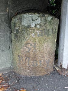
Location: |
On
the north side of Plymouth Road, Lee Mill, against the bridge parapet to
the west of the River Yealm. |
|
|
|
|
|
|
|
|
|
|
|
|
|
|
|
|
|
|
| Inscription: |
Plympton
St. Mary |
|
|
|
|
|
|
|
|
| |
|
|
|
|
|
|
|
|
|
|
|
|
|
|
|
|
| |
|
|
|
|
|
|
|
|
|
|
|
|
|
|
|
|
| |
|
|
|
|
|
|
|
|
|
|
|
|
|
|
| |
|
|
|
|
|
|
|
|
|
|
|
|
|
|
|
|
|
|
|
|
|
|
|
|
|
|
|
|
|
|
|
|
|
|
|
|
|
|
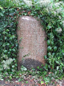
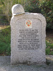
Stone Type: |
Marker
Stone |
|
|
|
|
|
|
|
|
Grid Reference: |
SX/6362/5631 |
|
|
|
|
|
|
|
|
Location: |
To
the north end of the Harford Road Car Park. |
|
|
|
|
|
|
|
|
Inscription: |
Dedicated
to the American Servicemen based in Ivybridge. |
|
|
|
|
|
|
|
|
Notes: |
Memorial
to the Servicemen based in the town during World War II. |
|
|
|
|
|
|
|
|
|
|
|
|
|
|
|
|
|
|
|
|
|
|
|
|
|
|
|
|
|
|
|
|
|
|
|
|
|
|
|
|
|
|
|
|
|
|
|
|
|
|
|
|
|
|
|
|
|
|
|
|
|
|
|
Stone Type: |
Marker
Stone |
|
|
|
|
|
|
|
|
Grid Reference: |
SX/6367/5598 |
|
|
|
|
|
|
|
|
Location: |
Beside
the roundabout at the eastern end of Marjorie Kelly Way. |
|
|
|
|
|
|
|
|
Inscription: |
Fore
Street Relief Road / Marjorie Kelly Way. |
|
|
|
|
|
|
|
|
|
|
|
|
|
|
|
|
|
|
|
|
|
|
|
|
|
|
|
|
|
|
|
|
|
|
|
|
|
|
|
|
|
|
|
|
|
|
|
|
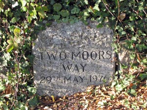
Stone Type: |
Marker
Stone |
|
|
|
|
|
|
|
Grid Reference: |
SX/6407/5676 |
|
|
|
|
|
|
|
Location: |
On
the west side of the road, to the south of Stowford Bridge. |
|
|
|
|
|
|
|
Inscription: |
Two
Moors Way / 29th May 1976. |
|
|
|
|
|
|
|
|
|
|
|
|
|
|
|
|
|
|
|
|
|
|
|
|
|
|
|
|
|
|
|
|
|
|
|
|
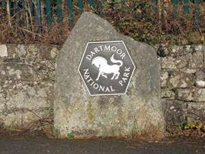
Stone Type: |
Boundary
Stone |
|
|
|
|
|
|
|
|
Grid Reference: |
SX/6408/5677 |
|
|
|
|
|
|
|
|
Location: |
On
the east side of the road, to the south of Stowford Bridge. |
|
|
|
|
|
|
|
|
Inscription: |
Dartmoor
National Park |
|
|
|
|
|
|
|
| Notes: |
Marks
the boundary of the National Park. |
|
|
|
|
|
|
|
|
|
|
|
|
|
|
|
|
|
|
|
|
|
|
|
|
|
|
|
|
|
|
|
|
|
|
|
|
|
|
|
|
|
|
|
|
|
|
|
|
|
|
|
|
|
|
|
|
|
|
|
| |
|
|
|
|
|
|
|
|
|
|
|
|
|
|
|
|
|
|
|
|
|
|
|
|
|
|
|
|
|
|
|
|
|
|
|
|
|
|
|