|
Devon Marker Stones |

|
|||||||||||||||||||||
 |
 |
 |
 |
 |
 |
 |
 |
 |
 |
 |
 |
 |
 |
 |
|
||||||||||||||||||||||||||||||||||||||||||
| District: | South Hams |
|
||||||||||||||||||||||||||||||||||||||||
| Parish: | South Brent | |||||||||||||||||||||||||||||||||||||||||
|
|
|||||||||||||||||||||||||||||||||||||||||
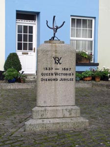
| Stone Type: | Village Jubilee Stone | |||||||||||||||||||||||||||||||||||||||||
| Grid Reference: | SX/6968/6022 | |||||||||||||||||||||||||||||||||||||||||
| Location: | Set into the cobbled area of Wellington Square, South Brent. | |||||||||||||||||||||||||||||||||||||||||
| Notes: | The stone marks Queen Victoria's Diamond Jubilee and Queen Elizabeth II's Silver, Golden & Diamond Jubilees. | |||||||||||||||||||||||||||||||||||||||||
|
||||||||||||||||||||||||||||||||||||||||||
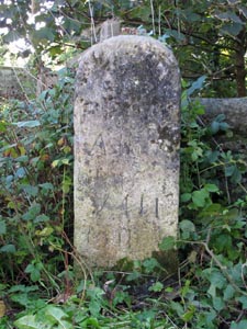
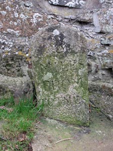
| Stone Type: | Milestone | |||||||||||||||||||||||||||||||||||||||||
| Grid Reference: | SX/6975/5956 | |||||||||||||||||||||||||||||||||||||||||
| Location: | Against the parapet at the eastern end of Brent Mill Bridge. | |||||||||||||||||||||||||||||||||||||||||
| Inscription: | From Ashburton VIII Miles. | |||||||||||||||||||||||||||||||||||||||||
|
||||||||||||||||||||||||||||||||||||||||||
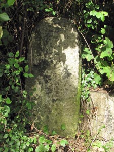
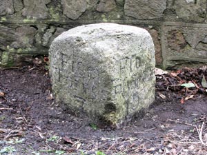
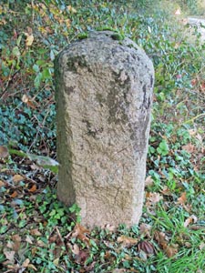
| Stone Type: | Boundary Stone | |||||||||||||||||||||||||||||||||||||||||
| Grid Reference: | SX/6966/5960 | |||||||||||||||||||||||||||||||||||||||||
| Location: | Abutting the end of the cottage garden wall. | |||||||||||||||||||||||||||||||||||||||||
| Inscription: | C - (County Bridge Stone - see note on Home Page) | |||||||||||||||||||||||||||||||||||||||||
|
||||||||||||||||||||||||||||||||||||||||||
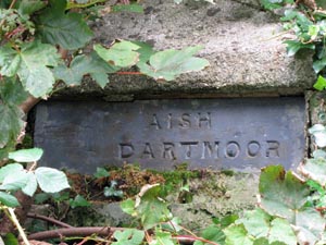
| Stone Type: | Guide Stone | |||||||||||||||||||||||||||||||||||||||||
| Grid Reference: | SX/6936/5950 | |||||||||||||||||||||||||||||||||||||||||
| Location: | Near the top of the left-hand disused gatepost in the lane leading to Aish. | |||||||||||||||||||||||||||||||||||||||||
| Inscription: | Aish / Dartmoor | |||||||||||||||||||||||||||||||||||||||||
| Notes: | The stone includes an inscribed hand to point the way. | |||||||||||||||||||||||||||||||||||||||||
|
||||||||||||||||||||||||||||||||||||||||||
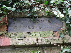
| Stone Type: | Milestone | |||||||||||||||||||||||||||||||||||||||||
| Grid Reference: | SX/6973/5950 | |||||||||||||||||||||||||||||||||||||||||
| Location: | Near the top of the right-hand disused gatepost in the lane leading to Aish. | |||||||||||||||||||||||||||||||||||||||||
| Inscription: | Ashburton 8 / Totnes 8 | |||||||||||||||||||||||||||||||||||||||||
| Notes: | The stone includes an inscribed hand to point the way. | |||||||||||||||||||||||||||||||||||||||||
|
||||||||||||||||||||||||||||||||||||||||||
| Stone Type: | Milestone | |||||||||||||||||||||||||||||||||||||||||
| Grid Reference: | SX/6952/5887 | |||||||||||||||||||||||||||||||||||||||||
| Location: | Against the stone wall near the Turtley Mill Inn, 20 metres to the east of the roadsign. | |||||||||||||||||||||||||||||||||||||||||
| Inscription: | From Totnes 7 / To Plymouth 15. | |||||||||||||||||||||||||||||||||||||||||
|
||||||||||||||||||||||||||||||||||||||||||
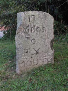
| Stone Type: | Milestone | |||||||||||||||||||||||||||||||||||||||||
| Grid Reference: | SX/7227/6068 | |||||||||||||||||||||||||||||||||||||||||
| Location: | On the grass verge, just to the north of the Totnes exit to the roundabout, at the Marley Head junction. | |||||||||||||||||||||||||||||||||||||||||
| Inscription: | 17 Miles to Plymouth / 6 Miles to Totnes. | |||||||||||||||||||||||||||||||||||||||||
|
||||||||||||||||||||||||||||||||||||||||||
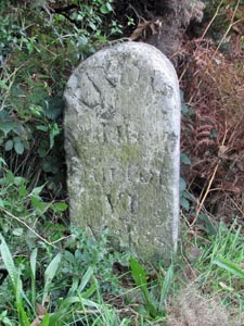
| Stone Type: | Milestone | |||||||||||||||||||||||||||||||||||||||||
| Grid Reference: | SX/7255/6169 | |||||||||||||||||||||||||||||||||||||||||
| Location: | Beside the emergency telephone post in the south-bound lay-by of the Devon Expressway, approaching the Marley Head junction. | |||||||||||||||||||||||||||||||||||||||||
| Inscription: | From Ashburton VI Miles. | |||||||||||||||||||||||||||||||||||||||||
|
||||||||||||||||||||||||||||||||||||||||||
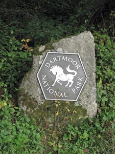
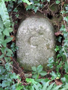
| Stone Type: | Boundary Stone | |||||||||||||||||||||||||||||||||||||||||
| Grid Reference: | SX/7196/6091 | |||||||||||||||||||||||||||||||||||||||||
| Location: | On the grass verge, on the north west side of the road leading from the Marley Head junction of the Devon Expressway towards Harbourneford Cross. | |||||||||||||||||||||||||||||||||||||||||
| Inscription: | Dartmoor National Park | |||||||||||||||||||||||||||||||||||||||||
| Notes: | This is one of a number of similar stones that have been erected to mark the bounds of the Dartmoor National Park. | |||||||||||||||||||||||||||||||||||||||||
|
||||||||||||||||||||||||||||||||||||||||||
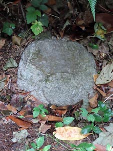
| Stone Type: | Boundary Stone | |||||||||||||||||||||||||||||||||||||||||
| Grid Reference: | SX/6815/6280 | |||||||||||||||||||||||||||||||||||||||||
| Location: | On the south west side of the lane leading to Shipley Bridge, just a few yards to the south of the bridge over the River Avon. | |||||||||||||||||||||||||||||||||||||||||
| Inscription: | C - (County Bridge Stone - see note on Home Page) | |||||||||||||||||||||||||||||||||||||||||
|
||||||||||||||||||||||||||||||||||||||||||
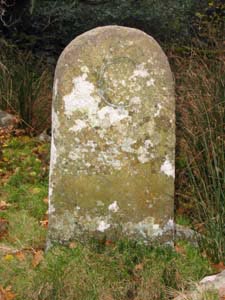
| Stone Type: | Bridge Date Stone | |||||||||||||||||||||||||||||||||||||||||
| Grid Reference: | SX/6791/6244 | |||||||||||||||||||||||||||||||||||||||||
| Location: | On the outside of the south-western parapet of the road bridge over the Bala Brook. | |||||||||||||||||||||||||||||||||||||||||
| Inscription: | 1810. | |||||||||||||||||||||||||||||||||||||||||
|
||||||||||||||||||||||||||||||||||||||||||
| Stone Type: | Milestone | |||||||||||||||||||||||||||||||||||||||||
| Grid Reference: | SX/6915/6078 | |||||||||||||||||||||||||||||||||||||||||
| Location: | On the grass verge, about 20 yards south east of the junction in the hamlet of Aish. | |||||||||||||||||||||||||||||||||||||||||
| Inscription: | 8 Miles From Totnes | |||||||||||||||||||||||||||||||||||||||||
|
||||||||||||||||||||||||||||||||||||||||||
| Stone Type: | Boundary Stone | |||||||||||||||||||||||||||||||||||||||||
| Grid Reference: | SX/6936/5897 | |||||||||||||||||||||||||||||||||||||||||
| Location: | On the northern verge of the slip road to the Plymouth-bound carriageway of the A38. | |||||||||||||||||||||||||||||||||||||||||
| Inscription: | There is no apparent inscription on this face. | |||||||||||||||||||||||||||||||||||||||||
| Notes: | The reverse face is inscribed 'Ugborough' | |||||||||||||||||||||||||||||||||||||||||
|
||||||||||||||||||||||||||||||||||||||||||
| Stone Type: | Boundary Stone | |||||||||||||||||||||||||||||||||||||||||
| Grid Reference: | SX/69122/59122 | |||||||||||||||||||||||||||||||||||||||||
| Location: | At the side of the road to the NE of Glaze Brook Bridge. | |||||||||||||||||||||||||||||||||||||||||
| Inscription: | C - (County Bridge Stone - see note on Home Page) | |||||||||||||||||||||||||||||||||||||||||
|
||||||||||||||||||||||||||||||||||||||||||
| Stone Type: | Boundary Stone | |||||||||||||||||||||||||||||||||||||||||
| Grid Reference: | SX/68978/59012 | |||||||||||||||||||||||||||||||||||||||||
| Location: | At the side of the road to the SW of Glaze Brook Bridge. | |||||||||||||||||||||||||||||||||||||||||
| Inscription: | C - (County Bridge Stone - see note on Home Page) | |||||||||||||||||||||||||||||||||||||||||