| |
|
|
|
|
|
|
|
|
|
|
|
|
| |
|
|
|
|
|
|
|
|
|
|
|
|
|
|
|
|
|
|
|
|
District: |
Teignbridge |
|
|
|
|
|
|
|
|
|
|
|
 |
|
| |
|
|
|
|
|
|
|
|
|
|
|
|
|
|
|
|
|
|
Parish: |
Ashburton |
 |
 |
 |
|
|
|
|
| |
|
|
|
|
|
|
|
|
|
|
|
|
|
|
|
|
|
|
|
| |
|
|
|
|
|
|
|
|
|
|
|
|
|
|
|
|
|
|
|
| |
|
|
|
|
|
|
|
|
|
|
|
|
|
|
|
|
|
|
|
| Page
Contents: |
|
| |
5 Boundary Stones |
| |
3 Crosses |
| |
1 Guide Stone |
| |
3 Marker Stones |
| |
2 Milestones |
| |
|
|
|
|
|
|
|
|
|
|
|
|
|
|
|
|
|
|
| |
|
|
|
|
|
|
|
|
|
|
|
|
|
| |
|
|
|
|
|
|
|
|
|
|
|
|
|
| |
|
|
|
|
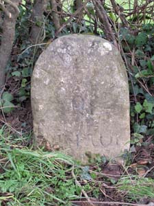
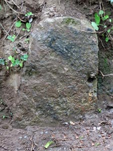
Stone Type: |
Milestone |
| |
|
|
|
|
Grid Reference: |
SX/7461/6876 |
| |
|
|
|
|
Location: |
On the eastern side of the old A38 on the approach to Ashburton |
| |
|
|
|
|
Notes: |
The Inscription is now illegible, but may have read 'Ashburton 1 Mile' |
| |
|
|
|
|
|
|
|
|
|
| |
|
|
|
|
|
|
|
|
|
|
|
|
|
|
|
|
| |
|
|
|
|
|
|
|
|
|
|
|
|
|
|
|
|
| |
|
|
|
|
|
|
|
|
|
|
|
|
|
|
|
|
|
|
|
|
|
|
|
|
|
|
|
|
|
|
|
|
| |
|
|
|
|
|
|
|
|
|
|
|
|
|
|
|
|
| |
|
|
|
|
|
|
|
|
|
|
|
|
|
|
|
|
|
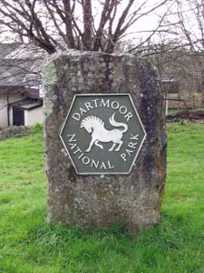
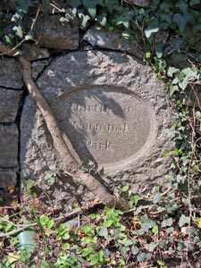
Stone Type: |
Boundary Stone |
|
|
|
|
|
|
|
|
|
Grid Reference: |
SX/7501/6931 |
|
|
|
|
|
|
|
|
|
Location: |
On the grass behind the Peartree Service Station |
|
|
|
|
|
|
|
|
|
Inscription: |
Dartmoor National Park (Boundary) |
|
|
|
|
|
|
|
|
| |
|
|
|
|
|
|
|
|
|
| |
|
|
|
|
|
|
|
|
|
|
|
|
|
|
|
|
| |
|
|
|
|
|
|
|
|
|
|
|
|
|
|
|
|
| |
|
|
|
|
|
|
|
|
|
|
|
|
|
| |
|
|
|
|
|
|
|
|
|
|
|
|
| |
|
|
|
|
|
|
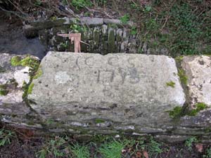
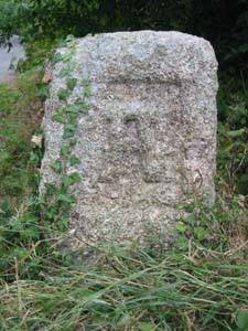
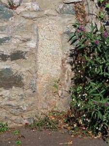
Stone Type: |
Marker Stone |
| |
|
|
|
|
|
|
Grid Reference: |
SX/7531/6935 |
| |
|
|
|
|
|
|
Location: |
Built into the top of the bridge parapet |
| |
|
|
|
|
|
|
Inscription: |
CCCS 1775 B (Meaning unknown) |
| |
|
|
|
|
|
|
|
|
|
|
|
|
|
|
|
|
|
|
|
|
|
|
|
| |
|
|
|
|
|
|
|
|
|
|
|
|
| |
|
|
|
|
|
|
|
|
|
|
|
|
|
|
|
|
|
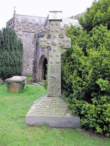
Stone Type: |
St Gudula's Cross |
|
|
|
|
|
|
|
|
|
Grid Reference: |
SX/7535/6936 |
|
|
|
|
|
|
|
|
|
Location: |
In Old Totnes Road, Ashburton, close to the stream. |
|
|
|
|
|
|
|
|
|
Notes: |
The cross is right next to St Gudula's Well |
|
|
|
|
|
|
|
|
| |
|
|
|
|
|
|
|
|
|
| |
|
|
|
|
|
|
|
|
|
|
|
|
|
|
|
|
| |
|
|
|
|
|
|
|
|
|
|
|
|
|
|
|
|
| |
|
|
|
|
|
|
|
|
|
|
|
|
|
| |
|
|
|
|
|
|
|
|
|
|
|
|
| |
|
|
|
|
|
|
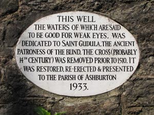
Stone Type: |
Marker Stone (Plaque) |
| |
|
|
|
|
|
|
Grid Reference: |
SX/7536/6936 |
| |
|
|
|
|
|
|
Location: |
In Old Totnes Road, Ashburton, close to the stream. |
| |
|
|
|
|
|
|
Inscription: |
This Well, the Waters of which are said to be Good for Weak Eyes, was
dedicated to St Gudula, the Ancient Patroness of the Blind. The Cross
(probably 14th Century) was removed prior to 1510. It was Restored,
Re-Erected and Presented to the Parish of Ashburton 1933. |
| |
|
|
|
|
|
|
|
|
|
|
|
|
|
|
|
|
|
|
|
|
|
|
|
| |
|
|
|
|
|
|
|
|
|
|
|
|
| |
|
|
|
|
|
|
|
|
|
|
|
|
|
|
|
|
|
Stone Type: |
Churchyard Cross |
|
|
|
|
|
|
|
|
|
Grid Reference: |
SX/7551/6977 |
|
|
|
|
|
|
|
|
|
Location: |
In the Ashburton Churchyard, to the right of the main path leading to the
Church. |
|
|
|
|
|
|
|
|
| |
|
|
|
|
|
|
|
|
|
| |
|
|
|
|
|
|
|
|
|
| |
|
|
|
|
|
|
|
|
|
|
|
|
|
|
|
|
| |
|
|
|
|
|
|
|
|
|
|
|
|
|
|
|
|
| |
|
|
|
|
|
|
|
|
|
|
|
|
|
|
| |
|
|
|
|
|
|
|
|
|
|
|
|
|
| |
|
|
|
|
|
|
|
|
|
|
|
|
|
|
|
|
| |
|
|
|
|
|
|
|
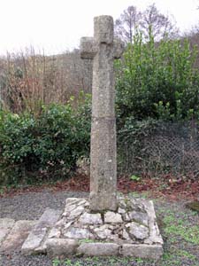
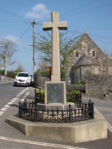
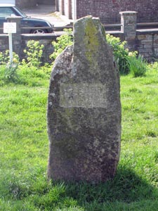
Stone Type: |
Town Cross |
| |
|
|
|
|
|
|
|
Grid Reference: |
SX/7595/7008 |
| |
|
|
|
|
|
|
|
Location: |
In the main street leading northwards out of Ashburton |
| |
|
|
|
|
|
|
|
Notes: |
The cross serves as the Town War Memorial. |
| |
|
|
|
|
|
|
|
|
|
| |
|
|
|
|
|
|
|
|
|
|
|
|
|
|
|
|
| |
|
|
|
|
|
|
|
|
|
|
|
|
|
|
|
|
|
|
|
|
|
|
|
|
|
|
|
|
|
|
|
|
| |
|
|
|
|
|
|
|
|
|
|
|
|
|
| |
|
|
|
|
|
|
|
|
|
|
|
|
|
|
|
|
|
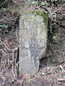
Stone Type: |
Milestone |
|
|
|
|
|
|
|
|
|
Grid Reference: |
SX/7689/7081 |
|
|
|
|
|
|
|
|
|
Location: |
On the north west side of the old A38, on the slip road to the Devon
Expressway. |
|
|
|
|
|
|
|
|
|
Inscription: |
From Ashburton II (From Ashburton 2 Miles) |
|
|
|
|
|
|
|
|
| |
|
|
|
|
|
|
|
|
|
| |
|
|
|
|
|
|
|
|
|
|
|
|
|
|
|
|
| |
|
|
|
|
|
|
|
|
|
|
|
|
|
|
|
|
| |
|
|
|
|
|
|
|
|
|
|
|
|
|
|
| |
|
|
|
|
|
|
|
|
|
|
|
|
|
| |
|
|
|
|
|
|
|
|
|
|
|
|
|
|
|
|
| |
|
|
|
|
|
|
|
Stone Type: |
Guide Stone |
| |
|
|
|
|
|
|
|
Grid Reference: |
SX/717/702 |
| |
|
|
|
|
|
|
|
Location: |
At the road junction, 1½ kilometres north east of Holne Village. |
| |
|
|
|
|
|
|
|
Inscription: |
A (Ashburton) / B (Buckfastleigh) / T (Tavistock). |
| |
|
|
|
|
|
|
|
|
|
| |
|
|
|
|
|
|
|
|
|
|
|
|
|
|
|
|
| |
|
|
|
|
|
|
|
|
|
|
|
|
|
|
|
|
|
|
|
|
|
|
|
|
|
|
|
|
|
|
|
|
| |
|
|
|
|
|
|
|
|
|
|
|
|
|
| |
|
|
|
|
|
|
|
|
|
|
|
|
|
|
|
|
|
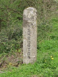
Stone Type: |
Boundary Stone |
|
|
|
|
|
|
|
|
|
Grid Reference: |
SX/7899/7212 |
|
|
|
|
|
|
|
|
|
Location: |
Next
to a field gateway, 50 metres west of the junction of the A383 with the
old A38. |
|
|
|
|
|
|
|
|
|
Inscription: |
2000
Ashburton |
|
|
|
|
|
|
|
|
| Notes: |
This
Boundary Stone was erected to mark the millennium and shares its boundary
with Bickington. |
|
|
|
|
|
|
|
|
| |
|
|
|
|
|
|
|
|
|
|
|
|
|
|
|
|
| |
|
|
|
|
|
|
|
|
|
|
|
|
|
|
|
|
| |
|
|
|
|
|
|
|
|
|
|
|
|
|
|
| |
|
|
|
|
|
|
|
|
|
|
|
|
|
|
|
|
|
|
|
|
|
|
|
|
|
|
|
|
|
|
|
|
|
|
|
|
|
|
Stone Type: |
Marker
Stone |
|
|
|
|
|
|
|
|
Grid Reference: |
SX/7546/7001 |
|
|
|
|
|
|
|
|
Location: |
On
the green at Cleder Place, North Street, Ashburton. |
|
|
|
|
|
|
|
|
Notes: |
The
inscription 'Cleder Place' is now missing, but a faint outline of the
words can still just be seen. |
|
|
|
|
|
|
|
|
|
|
|
|
|
|
|
|
|
|
|
|
|
|
|
|
|
|
|
| |
|
|
|
|
|
|
|
|
|
|
|
|
|
|
|
|
|
|
|
|
|
|
|
|
|
|
|
|
|
|
|
|
|
|
|
|
|
|
|
|
|
|
|
|
|
|
|
|
|
|
|
|
|
|
|
|
|
|
|
|
|
|
|
|
Stone Type: |
Boundary
Stone |
|
|
|
|
|
|
|
|
|
Grid Reference: |
SX7496/6931 |
|
|
|
|
|
|
|
|
|
Location: |
Set
back into the hedge of the road junction at Peartree Cross. |
|
|
|
|
|
|
|
|
|
Inscription: |
Dartmoor
National Park |
|
|
|
|
|
|
|
|
| Notes: |
This
was one of the original DNP boundary stones which have, more recently,
been replaced by large metal plates attached to stones. |
|
|
|
|
|
|
|
|
|
|
|
|
|
|
|
|
|
|
|
|
|
|
|
|
|
|
|
|
|
|
|
|
|
|
|
|
|
|
|
|
|
|
|
|
|
|
|
|
|
|
|
|
|
|
|
|
|
|
|
|
|
|
|
|
|
|
|
|
|
|
|
|
|
|
|
|
|
|
|
|
|
|
|
|
|
|
|
|
|
|
|
|
|
|
|
|
Stone Type: |
Boundary
Stone |
|
|
|
|
|
|
|
|
Grid Reference: |
SX7656/6948 |
|
|
|
|
|
|
|
|
Location: |
15
yards east of the road junction at Whistley Hill. |
|
|
|
|
|
|
|
|
Inscription: |
The
inscription is no longer visible but would have shown '1 Mile'. |
|
|
|
|
|
|
|
|
Notes: |
This
is a Parole Stone which shows the limit to where French Prison of War
Officers were allowed walk during the Napoleonic Wars. |
|
|
|
|
|
|
|
|
|
|
|
|
|
|
|
|
|
| |
|
|
|
|
|
|
|
|
|
|
|
|
|
|
|
|
|
|
|
|
|
|
|
|
|
|
|
|
|
|
|
|
|
|
|
|
|
|
|
|
|
|
|
|
|
|
|
|
|
|
|
|
|
|
|
|
|
|
|
|
|
|
|
|
Stone Type: |
Boundary
Stone |
|
|
|
|
|
|
|
|
|
Grid Reference: |
SX/7539/6940 |
|
|
|
|
|
|
|
|
|
Location: |
Built
into the garden wall of No: 8 Old Totnes Road. |
|
|
|
|
|
|
|
|
|
Inscription: |
C
- (County Bridge Stone - see note on Home Page) |
|
|
|
|
|
|
|
|
|
|
|
|
|
|
|
|
|
|
|
|
|
|
|
|
|
|
|
|
|
|
|
|
|
|
|
|
|
|
|
|
|
|
|
|
|
|
|
|
|
|
|
|
|
|
|
|
|
|
|
|
|
|
|
|
|
|
|
|
|
|
|
|
|
|
|
|
|
|
|
|
|
|
|
|
|
|
|
|
|
|
|
|
|
|
|
|
|
|
|
|
|
|
|
|
|
|
| |
|
|
|
|
|
|
|
|
|
|
|
|
|
|
|
|
|
|
|
|
|
|
|
|
|
|
|
|
|
|
|
|
|
|
|
|
|
|
|