| |
|
|
|
|
|
|
|
|
|
|
|
|
| |
|
|
|
|
|
|
|
|
|
|
|
|
|
|
|
|
|
|
|
|
District: |
Teignbridge |
|
|
|
|
|
|
|
|
|
|
|
 |
|
| |
|
|
|
|
|
|
|
|
|
|
|
|
|
|
|
|
|
|
Parish: |
Dawlish |
 |
 |
 |
|
|
|
|
| |
|
|
|
|
|
|
|
|
|
|
|
|
|
|
|
|
|
|
|
| |
|
|
|
|
|
|
|
|
|
|
|
|
|
|
|
|
|
|
|
| |
|
|
|
|
|
|
|
|
|
|
|
|
|
|
|
|
|
|
|
| Page
Contents: |
|
| |
9 Boundary Stones |
| |
2 Bridge Plaques |
| |
2 Crosses |
| |
3 Milestones |
| |
|
| |
|
|
|
|
|
|
|
|
|
|
|
|
|
|
|
|
|
|
| |
|
|
|
|
|
|
|
|
|
|
|
|
|
| |
|
|
|
|
|
|
|
|
|
|
|
|
|
| |
|
|
|
|
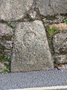
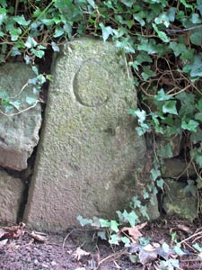
Stone Type: |
Boundary Stone |
| |
|
|
|
|
Grid Reference: |
SX/9549/7685 |
| |
|
|
|
|
Location: |
Set into the base of a garden wall on the south side of Old Town Street,
Dawlish. |
| |
|
|
|
|
Inscription: |
C - (County Bridge Stone - see note on Home Page) |
| |
|
|
|
|
|
|
|
Notes: |
The stone marks the limit for the maintenance of the road leading to the
bridge over the Dawlish Water in Church Street. |
| |
|
|
|
|
|
|
|
|
|
|
|
|
|
|
|
|
| |
|
|
|
|
|
|
|
|
|
|
|
|
|
|
|
|
|
|
|
|
|
|
|
|
|
|
|
|
|
|
|
|
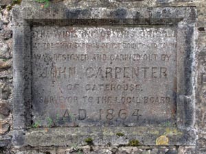
Stone Type: |
Bridge Plaque |
|
|
|
|
|
Grid Reference: |
SX/9543/7680 |
|
|
|
|
|
|
|
|
Location: |
Set into the east parapet of the bridge over the Dawlish Water in Church
Street, Dawlish. |
|
|
|
|
|
|
|
|
Inscription: |
The Widening of this Bridge at the Joint Expense of the County and Town was
Designed and carried out by John Carpenter of Gatehouse. Surveyor to the
Local Board AD 1864; |
|
|
|
|
|
|
|
|
|
|
|
|
|
|
|
|
|
|
|
|
|
|
|
|
|
|
|
|
|
|
|
|
|
|
|
|
|
|
|
|
|
|
|
|
|
|
|
|
|
|
|
|
|
|
|
|
|
|
|
|
|
|
|
|
|
|
|
|
|
|
|
|
|
|
|
|
|
|
|
|
|
|
|
|
|
|
|
|
|
|
|
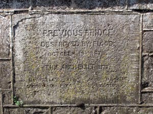
Stone Type: |
Bridge Plaque |
|
|
|
|
|
|
|
|
Grid Reference: |
SX/9542/7679 |
|
|
|
|
|
|
|
|
Location: |
Set into the west parapet of the bridge over the Dawlish Water in Church
Street, Dawlish. |
|
|
|
|
|
|
|
|
Inscription: |
Previous Bridge Destroyed by Flood October 19th 1873. This Arch Built 1876.
?? Earley County Surveyor. James Hawkins Builder; |
|
|
|
|
|
|
|
|
Notes: |
The name of the County Surveyor is not clear on the plaque and has been read
the best I can! |
|
|
|
|
|
|
|
|
|
|
|
|
|
|
|
|
|
|
|
|
|
|
|
|
|
|
|
|
|
|
|
|
| |
|
|
|
|
|
|
|
|
|
|
|
|
|
|
|
|
| |
|
|
|
|
|
|
|
|
|
|
|
|
|
|
|
|
|
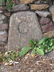
Stone Type: |
Boundary Stone |
|
|
|
|
|
|
|
|
|
Grid Reference: |
SX/9505/7684 |
|
|
|
|
|
|
|
|
|
Location: |
Set into the retaining wall on the north west side of Aller Hill, opposite
the entrance to Stonelands Mews. |
|
|
|
|
|
|
|
|
|
Inscription: |
C - (County Bridge Stone - see note on Home Page) |
|
|
|
|
|
|
|
|
|
|
|
|
|
|
|
|
|
|
| |
|
|
|
|
|
|
|
|
|
|
|
|
|
|
|
|
| |
|
|
|
|
|
|
|
|
|
|
|
|
|
|
| |
|
|
|
|
|
|
|
|
|
|
|
|
|
| |
|
|
|
|
|
|
|
|
|
|
|
|
|
|
|
|
|
|
|
|
|
|
|
|
|
|
|
|
|
|
|
|
|
|
|
|
|
|
|
|
Stone Type: |
Boundary Stone |
|
|
|
|
|
|
|
|
|
Grid Reference: |
SX/9504/7667 |
|
|
|
|
|
|
|
|
|
Location: |
Set
into the garden wall of Brownsbrook Cottage on the west side of Aller Hill
and to the north of the bridge over the road. |
|
|
|
|
|
|
|
|
|
Inscription: |
C - (County Bridge Stone - see note on Home Page) |
|
|
|
|
|
|
|
|
|
|
|
|
|
|
|
|
|
|
|
|
|
|
|
|
|
|
|
| |
|
|
|
|
|
|
|
|
|
|
|
|
|
| |
|
|
|
|
|
|
|
|
|
|
|
|
|
|
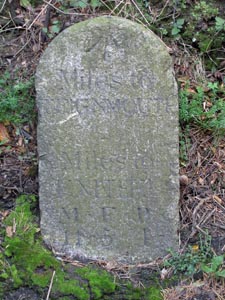
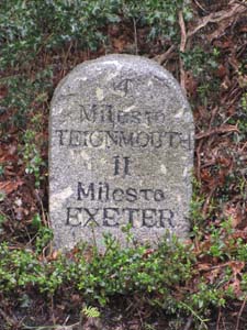
Stone Type: |
Milestone |
|
|
|
|
|
|
|
|
|
Grid Reference: |
SX/9237/7540 |
|
|
|
|
|
|
|
|
|
Location: |
Set into the verge on the south side of the B3192 Higher Exeter Road, just
to the east of the junction that leads off to the Teignmouth Golf Club. |
|
|
|
|
|
|
|
|
|
Inscription: |
Miles to Teignmouth / Miles to Exeter 11M (Miles) 5F (Furlongs) 4P (Poles).
|
|
|
|
|
|
|
|
|
|
Notes: |
The number of miles to Teignmouth seems to have been obscured by the
addition of an Ordnance Survey Bench Mark arrow. |
|
|
|
|
|
|
|
|
| |
|
|
|
|
|
|
|
|
|
|
|
|
|
|
|
|
| |
|
|
|
|
|
|
|
|
|
|
|
|
|
|
| |
|
|
|
|
|
|
|
|
|
|
|
|
|
| |
|
|
|
|
|
|
|
|
|
|
|
|
|
|
|
|
|
|
|
|
|
|
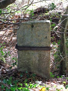
Stone Type: |
Boundary Stone |
|
|
|
|
|
|
|
|
|
Grid Reference: |
SX/9226/7535 |
|
|
|
|
|
|
|
|
|
Location: |
Set back under the trees in the junction between two minor roads. |
|
|
|
|
|
|
|
|
|
Inscription: |
No apparent inscription on this stone. |
|
|
|
|
|
|
|
|
|
Notes: |
This
stone is quite fragile and has been protected with a metal band around it,
which is itself now rusting away quite badly. |
|
|
|
|
|
|
|
|
|
|
|
|
|
|
|
|
|
|
|
|
|
|
|
|
|
|
|
|
|
|
|
|
|
|
| |
|
|
|
|
|
|
|
|
|
|
|
|
|
| |
|
|
|
|
|
|
|
|
|
|
|
|
|
|
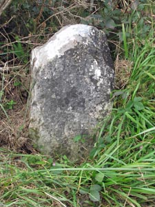
Stone Type: |
Boundary Stone |
|
|
|
|
|
|
|
|
|
Grid Reference: |
SX/9201/7657 |
|
|
|
|
|
|
|
|
|
Location: |
Set into the roadside bank on the north west side and half way along the
lane that runs between the B3192 Higher Exeter Road and Luscombe Hill. |
|
|
|
|
|
|
|
|
|
Inscription: |
B - M (Ordnance Survey Bench Mark). |
|
|
|
|
|
|
|
|
|
|
|
|
|
|
|
|
|
|
| |
|
|
|
|
|
|
|
|
|
|
|
|
|
|
|
|
| |
|
|
|
|
|
|
|
|
|
|
|
|
|
|
|
|
| |
|
|
|
|
|
|
|
|
|
|
|
|
|
|
| |
|
|
|
|
|
|
|
|
|
|
|
|
|
|
|
|
|
|
|
|
|
|
|
|
|
|
|
|
|
|
|
|
|
|
|
|
|
|
Stone Type: |
Milestone |
|
|
|
|
|
|
|
|
Grid Reference: |
SX/9679/7810 |
|
|
|
|
|
|
|
|
Location: |
Set
back from the road on the eastern verge of A379. |
|
|
|
|
|
|
|
|
Inscription: |
4 Miles To
Teignmouth / 11 Miles To Exeter |
|
|
|
|
|
|
|
|
|
|
|
|
|
|
|
|
|
|
|
|
|
|
|
|
|
|
|
|
|
|
|
|
|
|
|
|
|
|
|
|
|
|
|
|
|
|
|
|
|
|
|
|
|
|
|
|
|
|
|
|
|
|
|
|
|
|
|
|
|
|
|
|
|
|
|
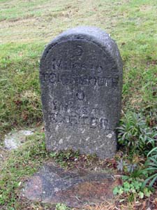
Stone Type: |
Milestone |
|
|
|
|
|
|
|
|
|
Grid Reference: |
SX/9641/7963 |
|
|
|
|
|
|
|
|
|
Location: |
On
the eastern verge of A379, beside a low wall. |
|
|
|
|
|
|
|
|
|
Inscription: |
5 Miles To
Teignmouth / 10 Miles To Exeter |
|
|
|
|
|
|
|
|
|
|
|
|
|
|
|
|
|
|
|
|
|
|
|
|
|
|
|
|
|
|
|
|
|
|
|
|
|
|
|
|
|
|
|
|
|
|
|
|
|
|
|
|
|
|
|
|
|
|
|
|
|
|
|
|
|
|
|
|
|
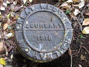
Stone Type: |
Metal
Boundary Marker |
|
|
|
|
|
|
|
Grid Reference: |
SX/9712/7747 |
|
|
|
|
|
|
|
Location: |
On
the cliff path, near the Rockstone. |
|
|
|
|
|
|
|
Inscription: |
Great
Western Railway Cos. Boundary 1918 |
| |
|
|
|
|
|
|
|
|
|
|
|
|
|
|
|
|
|
|
|
|
|
|
|
|
|
|
|
|
|
|
|
|
|
|
|
|
|
|
|
|
|
|
|
|
|
|
|
|
|
|
|
|
|
|
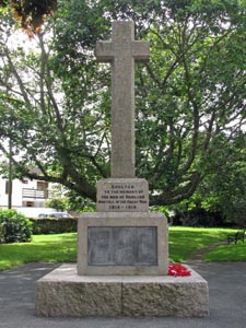
Stone Type: |
Churchyard
Cross |
|
|
|
|
|
|
|
|
|
Grid Reference: |
SX/9535/7662 |
|
|
|
|
|
|
|
|
|
Location: |
Set
back to the left of the approach to St Gregory's Churchyard. |
|
|
|
|
|
|
|
|
|
Inscription: |
Erected
to the Memory of the Men of Dawlish who fell in the Great War 1914 - 1918. |
|
|
|
|
|
|
|
|
| Notes: |
The
cross serves as a memorial for World War I & II. |
|
|
|
|
|
|
|
|
|
|
|
|
|
|
|
|
|
|
|
|
|
|
|
|
|
|
|
|
|
|
|
|
|
|
|
|
|
|
|
|
|
|
|
|
|
|
|
|
|
|
|
|
|
|
|
|
|
|
|
|
|
|
|
|
|
|
|
|
|
|
|
|
|
|
|
|
|
|
|
|
|
|
|
|
|
|
|
|
|
|
|
|
|
|
|
|
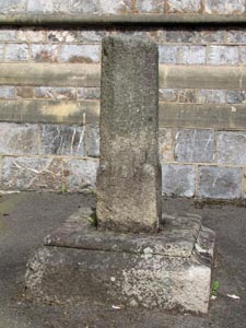
Stone Type: |
Town
Cross |
|
|
|
|
|
|
|
|
Grid Reference: |
SX/9535/7664 |
|
|
|
|
|
|
|
|
Location: |
Set
close to the church wall on the approach to St Gregory's Churchyard. |
|
|
|
|
|
|
|
|
Notes: |
This
is probably an ancient preaching cross relocated to the church for
safekeeping. |
|
|
|
|
|
|
|
|
|
|
|
|
|
|
|
|
|
|
|
|
|
|
|
|
|
|
|
|
|
|
|
|
|
|
|
|
|
|
|
|
|
|
|
|
|
|
|
|
|
|
|
|
|
|
|
|
|
|
|
|
|
|
|
|
|
|
|
|
|
|
|
|
|
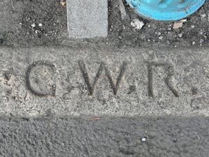
Stone Type: |
Boundary
Stone |
|
|
|
|
|
|
|
|
Grid Reference: |
SX/964/767 |
|
|
|
|
|
|
|
|
Location: |
Inscribed
into the top of a kerb stone, on the opposite side of the road to the
railway station. |
|
|
|
|
|
|
|
|
Inscription: |
G.W.R.
(Great Western Railway) |
|
|
|
|
|
|
|
|
|
|
|
|
|
|
|
|
|
|
|
|
|
|
|
|
|
|
|
|
|
|
|
|
|
|
|
|
|
|
|
|
|
|
|
|
|
|
|
|
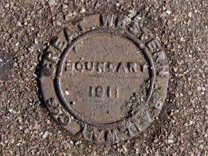
Stone Type: |
Metal
Boundary Marker |
|
|
|
|
|
|
|
Grid Reference: |
SX/9776/7794 |
|
|
|
|
|
|
|
Location: |
Flush
with the cliff path, up the hill from the Langstone Cliff Hotel |
|
|
|
|
|
|
|
Inscription: |
Great
Western Railway Cos. Boundary 1911 |
|
|
|
|
|
|
|
|
|
|
|
|
|
|
|
|
|
|
|
|
|
|
|
|
|
|
|
|
|
|
|
|
|
|
|
|
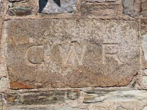
Stone Type: |
Boundary
Stone |
|
|
|
|
|
|
|
|
Grid Reference: |
SX/9642/7674 |
|
|
|
|
|
|
|
|
Location: |
Built
into the back wall of the Dawlish Station car park. |
|
|
|
|
|
|
|
|
Inscription: |
G
W R (Great Western Railway) |
|
|
|
|
|
|
|
|
|
|
|
|
|
|
|
|
|
|
|
|
|
|
|
|
|
|
|
|
|
|
|
|
|
|
|
|
|
|
|
|
|
|
|
|
|
|
|
|
|
|
|
|
|
|
|
|
|
|
|
|
|
|
|
|
|
|
|
|
| |
|
|
|
|
|
|
|
|
|
|
|
|
|
|
|
|
|
|
|
|
|
|
|
|
|
|
|
|
|
|
|
|
|
|
|
|
|
|
|