| |
|
|
|
|
|
|
|
|
|
|
|
|
| |
|
|
|
|
|
|
|
|
|
|
|
|
|
|
|
|
|
|
|
|
District: |
Teignbridge |
|
|
|
|
|
|
|
|
|
|
|
 |
|
| |
|
|
|
|
|
|
|
|
|
|
|
|
|
|
|
|
|
|
Parish: |
Newton Abbot |
 |
 |
 |
|
|
|
|
| |
|
|
|
|
|
|
|
|
|
|
|
|
|
|
|
|
|
|
|
| |
|
|
|
|
|
|
|
|
|
|
|
|
|
|
|
|
|
|
|
| |
|
|
|
|
|
|
|
|
|
|
|
|
|
|
|
|
|
|
|
| Page
Contents: |
|
| |
7 Boundary Stones |
| |
1 Cross |
| |
6 Marker Stones |
| |
3 Milestones |
| |
|
| |
|
|
|
|
|
|
|
|
|
|
|
|
|
|
|
|
|
|
| |
|
|
|
|
|
|
|
|
|
|
|
|
|
| |
|
|
|
|
|
|
|
|
|
|
|
|
|
| |
|
|
|
|
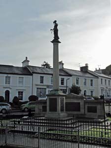
Stone Type: |
Town War Memorial |
| |
|
|
|
|
Grid Reference: |
SX/8644/7134 |
| |
|
|
|
|
Location: |
At the junction of The Avenue and Queen Street, Newton Abbot. |
| |
|
|
|
|
Inscription: |
Pro Patria / These Tablets were Erected to Honour and Record the Names of
Those who made the Supreme Sacrifice |
| |
|
|
|
|
|
|
|
|
|
| |
|
|
|
|
|
|
|
|
|
|
|
|
|
|
|
|
| |
|
|
|
|
|
|
|
|
|
|
|
|
|
|
|
|
| |
|
|
|
|
|
|
|
|
|
|
|
|
|
|
|
|
|
|
|
|
|
|
|
|
|
|
|
|
|
|
|
|
| |
|
|
|
|
|
|
|
|
|
|
|
|
|
|
|
|
| |
|
|
|
|
|
|
|
|
|
|
|
|
|
|
|
|
|
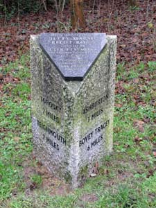
Stone Type: |
Milestone |
|
|
|
|
|
|
|
|
|
Grid Reference: |
SX/8564/7201 |
|
|
|
|
|
|
|
|
|
Location: |
On the south side of Jetty Marsh Road, Newton Abbot, about 40 metres down
from the roundabout (with the A382). |
|
|
|
|
|
|
|
|
|
Inscription: |
Torquay 7 Miles / Teignmouth 7 Miles / Ashburton 7 Miles / Bovey Tracey 6
Miles. |
|
|
|
|
|
|
|
|
|
Plaque Inscription: |
Devon County Council / Jetty Marsh Relief Road / Opened by Cllr. F J Symons
/ Vice Chairman County Council / June 1998 |
|
|
|
|
|
|
|
|
|
|
|
|
|
|
|
|
|
|
|
|
|
|
|
|
|
| |
|
|
|
|
|
|
|
|
|
|
|
|
|
|
|
|
| |
|
|
|
|
|
|
|
|
|
|
|
|
|
|
| |
|
|
|
|
|
|
|
|
|
|
|
|
|
| |
|
|
|
|
|
|
|
|
|
|
|
|
|
|
|
|
| |
|
|
|
|
|
|
|
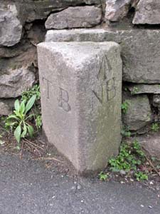
Stone Type: |
Boundary Stone |
| |
|
|
|
|
|
|
|
Grid Reference: |
SX/8546/7097 |
| |
|
|
|
|
|
|
|
Location: |
On the north side of the A381, Newton Abbot to Abbotskerswell Road, at the
junction with Linden Terrace. |
| |
|
|
|
|
|
|
|
Inscription: |
T B / N B |
| |
|
|
|
|
|
|
|
Notes: |
The stone also has an Ordnance Survey benchmark. |
| |
|
|
|
|
|
|
|
|
|
|
|
|
|
|
|
|
| |
|
|
|
|
|
|
|
|
|
|
|
|
|
|
|
|
|
|
|
|
|
|
|
|
|
|
|
|
|
|
|
|
| |
|
|
|
|
|
|
|
|
|
|
|
|
|
| |
|
|
|
|
|
|
|
|
|
|
|
|
|
|
|
|
|
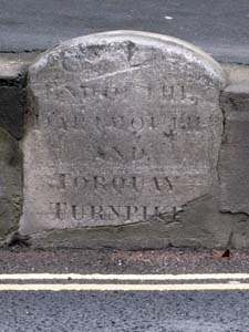
Stone Type: |
Turnpike Marker Stone |
|
|
|
|
|
|
|
|
|
Grid Reference: |
SX/8616/7113 |
|
|
|
|
|
|
|
|
|
Location: |
Built into the raised footpath wall on the south side of East Street,
opposite the King Street junction. |
|
|
|
|
|
|
|
|
|
Inscription: |
End of the Dartmouth and Torquay Turnpike. |
|
|
|
|
|
|
|
|
|
|
|
|
|
|
|
|
|
|
| |
|
|
|
|
|
|
|
|
|
|
|
|
|
|
|
|
| |
|
|
|
|
|
|
|
|
|
|
|
|
|
|
|
|
| |
|
|
|
|
|
|
|
|
|
|
|
|
|
|
| |
|
|
|
|
|
|
|
|
|
|
|
|
|
| |
|
|
|
|
|
|
|
|
|
|
|
|
|
|
|
|
| |
|
|
|
|
|
|
|
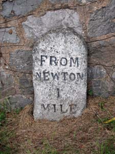
Stone Type: |
Milestone |
| |
|
|
|
|
|
|
|
Grid Reference: |
SX/8728/7064 |
| |
|
|
|
|
|
|
|
Location: |
Set against the wall on the north side of Shaldon Road, Newton Abbot, a few
metres to the west of the Queensway Junction. |
| |
|
|
|
|
|
|
|
Inscription: |
From Newton 1 Mile |
| |
|
|
|
|
|
|
|
|
|
| |
|
|
|
|
|
|
|
|
|
|
|
|
|
|
|
|
| |
|
|
|
|
|
|
|
|
|
|
|
|
|
|
|
|
|
|
|
|
|
|
|
|
|
|
|
|
|
|
|
|
| |
|
|
|
|
|
|
|
|
|
|
|
|
|
| |
|
|
|
|
|
|
|
|
|
|
|
|
|
|
|
|
|
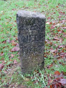
Stone Type: |
Marker Stone |
|
|
|
|
|
|
|
|
|
Grid Reference: |
SX/8777/7047 |
|
|
|
|
|
|
|
|
|
Location: |
On the grass verge at the junction of St Marychurch Road and Newtake Rise,
Newton Abbot. |
|
|
|
|
|
|
|
|
|
Inscription: |
Rey Mill 1743 |
|
|
|
|
|
|
|
|
|
|
|
|
|
|
|
|
|
|
| |
|
|
|
|
|
|
|
|
|
|
|
|
|
|
|
|
| |
|
|
|
|
|
|
|
|
|
|
|
|
|
|
|
|
| |
|
|
|
|
|
|
|
|
|
|
|
|
|
|
| |
|
|
|
|
|
|
|
|
|
|
|
|
|
| |
|
|
|
|
|
|
|
|
|
|
|
|
|
|
|
|
| |
|
|
|
|
|
|
|
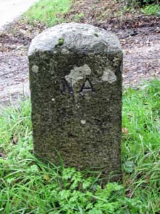
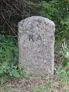
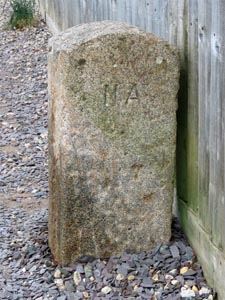
Stone Type: |
Boundary Stone |
| |
|
|
|
|
|
|
|
Grid Reference: |
SX/8828/7102 |
| |
|
|
|
|
|
|
|
Location: |
On the grass verge, on the south east side of Shaldon Road, at the top of
the hill and very close to the 40mph sign. |
| |
|
|
|
|
|
|
|
Inscription: |
N A (Newton Abbot) - The reverse side shows H C (Haccombe with Combe). |
| |
|
|
|
|
|
|
|
|
|
| |
|
|
|
|
|
|
|
|
|
|
|
|
|
|
|
|
| |
|
|
|
|
|
|
|
|
|
|
|
|
|
|
|
|
|
|
|
|
|
|
|
|
|
|
|
|
|
|
|
|
| |
|
|
|
|
|
|
|
|
|
|
|
|
|
| |
|
|
|
|
|
|
|
|
|
|
|
|
|
|
|
|
|
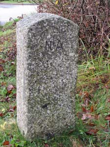
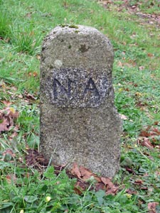
Stone Type: |
Boundary Stone |
|
|
|
|
|
|
|
|
|
Grid Reference: |
SX/8424/7328 |
|
|
|
|
|
|
|
|
|
Location: |
On the grass verge at Forches Cross, Newton Abbot on the A382. |
|
|
|
|
|
|
|
|
|
Inscription: |
N A (Newton Abbot) - The reverse side shows T G (Teigngrace). |
|
|
|
|
|
|
|
|
| Notes: |
The
stone shares its boundary with Teigngrace. |
|
|
|
|
|
|
|
|
| |
|
|
|
|
|
|
|
|
|
|
|
|
|
|
|
|
| |
|
|
|
|
|
|
|
|
|
|
|
|
|
|
|
|
| |
|
|
|
|
|
|
|
|
|
|
|
|
|
|
| |
|
|
|
|
|
|
|
|
|
|
|
|
|
| |
|
|
|
|
|
|
|
|
|
|
|
|
|
|
|
|
| |
|
|
|
|
|
|
|
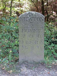
Stone Type: |
Milestone |
| |
|
|
|
|
|
|
|
Grid Reference: |
SX/8320/7489 |
| |
|
|
|
|
|
|
|
Location: |
On the south west side of the A382, almost opposite the entrance to the
Stover Country Park. |
| |
|
|
|
|
|
|
|
Inscription: |
Newton 3; Bovey 2.6.0; Moreton 9.2.0. |
| |
|
|
|
|
|
|
|
Notes: |
The stone also has an Ordnance Survey benchmark at the top of its main face. |
| |
|
|
|
|
|
|
|
|
|
|
|
|
|
|
|
|
| |
|
|
|
|
|
|
|
|
|
|
|
|
|
|
|
|
|
|
|
|
|
|
|
|
|
|
|
|
|
|
|
| |
|
|
|
|
|
|
|
|
|
|
|
|
|
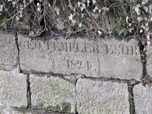
Stone Type: |
Marker Stone |
|
|
|
|
|
|
|
|
Grid Reference: |
SX/861/721 |
|
|
|
|
|
|
|
|
Location: |
Built into the end of the jetty wall on the Stover Canal. |
|
|
|
|
|
|
|
|
Inscription: |
Geo. Templer Esqr. 1824 |
|
|
|
|
|
|
|
|
|
|
|
|
|
|
|
|
| |
|
|
|
|
|
|
|
|
|
|
|
|
|
| |
|
|
|
|
|
|
|
|
|
|
|
|
|
|
|
|
|
|
|
|
|
|
|
|
|
|
|
|
|
|
|
|
|
|
|
|
|
Stone Type: |
Boundary
Stone |
|
|
|
|
|
|
|
|
Grid Reference: |
SX/8309/7506 |
|
|
|
|
|
|
|
|
Location: |
On
the north-east verge of the A382, at the entrance of the cycle path to the
Stover Country Park. |
|
|
|
|
|
|
|
|
Inscription: |
N
A (Newton Abbot) |
|
|
|
|
|
|
|
|
Notes: |
The
stone shares its border with the Parish of Ilsington. |
|
|
|
|
|
|
|
|
|
|
|
|
|
|
|
|
|
|
|
|
|
|
|
|
|
|
|
|
|
|
|
|
|
|
|
|
|
|
|
|
|
|
|
|
|
|
|
|
|
|
|
|
|
|
|
|
|
|
|
|
|
|
|
|
|
|
|
|
|
|
|
|
|
|
|
|
|
|
|
|
|
|
|
|
|
|
|
|
|
|
|
|
|
|
|
|
|
|
|
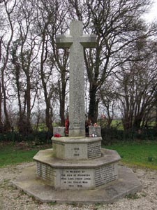
Stone Type: |
Churchyard
Cross |
|
|
|
|
|
|
|
|
|
Grid Reference: |
SX/8518/7212 |
|
|
|
|
|
|
|
|
|
Location: |
At
the back of the Highweek Parish Churchyard. |
|
|
|
|
|
|
|
|
|
Notes: |
The
cross serves as the parish war memorial. |
|
|
|
|
|
|
|
|
|
|
|
|
|
|
|
|
|
|
|
|
|
|
|
|
|
|
|
|
|
|
|
|
|
|
|
|
|
|
|
|
|
|
|
|
|
|
|
|
|
|
|
|
|
|
|
|
|
|
|
|
|
|
|
|
|
|
|
|
|
|
|
|
|
|
|
|
|
|
|
|
|
|
|
|
|
|
|
|
|
|
|
|
|
|
|
|
|
|
|
|
|
|
|
|
|
|
Stone Type: |
Boundary
Stone |
|
|
|
|
|
|
|
|
Grid Reference: |
SX/8331/7467 |
|
|
|
|
|
|
|
|
Location: |
On
the western verge of the A382, just south of the roundabout. |
|
|
|
|
|
|
|
|
Inscription: |
N
A (Newton Abbot) |
|
|
|
|
|
|
|
|
Notes: |
The
stone shares it's Boundary with Ilsington. |
|
|
|
|
|
|
|
|
|
|
|
|
|
|
|
|
|
|
|
|
|
|
|
|
|
|
|
|
|
|
|
|
|
|
|
|
|
|
|
|
|
|
|
|
|
|
|
|
|
|
|
|
|
|
|
|
|
|
|
|
|
|
|
|
|
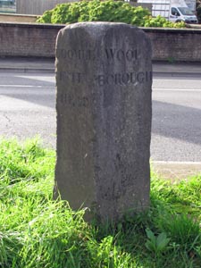
Stone Type: |
Boundary
Stone |
|
|
|
|
|
|
|
|
|
Grid Reference: |
SX/8704/7069 |
|
|
|
|
|
|
|
|
|
Location: |
In
the central reservation of Torquay Road (A381), just to the west of the
Penn Inn Roundabout. |
|
|
|
|
|
|
|
|
|
Inscription: |
Coombeintinhead / Woolborough |
|
|
|
|
|
|
|
|
|
|
|
|
|
|
|
|
|
|
|
|
|
|
|
|
|
|
|
|
|
|
|
|
|
|
|
|
|
|
|
|
|
|
|
|
|
|
|
|
|
|
|
|
|
|
|
|
|
|
|
|
|
|
|
|
|
|
|
|
|
|
|
|
|
|
|
|
|
|
|
|
|
|
|
|
|
|
|
|
|
|
|
|
|
|
|
|
|
|
|
|
|
|
|
|
|
|
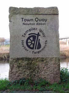
Stone Type: |
Marker
Stone |
|
|
|
|
|
|
|
|
Grid Reference: |
SX/8691/7163 |
|
|
|
|
|
|
|
|
Location: |
On
the south west bank of the River Teign at the Town Quay. |
|
|
|
|
|
|
|
|
Inscription: |
Town
Quay / Newton Abbot / Templer Way / Haytor / Teignmouth |
|
|
|
|
|
|
|
|
Notes: |
The
stone marks the path of the Templer Way through Newton Abbot. |
|
|
|
|
|
|
|
|
|
|
|
|
|
|
|
|
|
| |
|
|
|
|
|
|
|
|
|
|
|
|
|
|
|
|
|
|
|
|
|
|
|
|
|
|
|
|
|
|
|
|
|
|
|
|
|
|
|
|
|
|
|
|
|
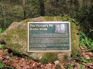
Stone Type: |
Marker Stone |
|
|
|
|
|
|
|
|
Grid Reference: |
SX8441/7088 |
|
|
|
|
|
|
|
|
Location: |
Beside the path above Puritan's Pit,
Bradley Woods. |
|
|
|
|
|
|
|
|
Inscription: |
The Puritan's Pit / Bradley Woods |
|
|
|
|
|
|
|
| Notes: |
The plaque attached to the stone
relates the history of the pit. |
|
|
|
|
|
|
|
|
|
|
|
|
|
|
|
|
|
|
|
|
|
|
|
|
|
|
|
|
|
|
|
|
|
|
|
|
|
|
|
|
|
|
|
|
|
|
|
|
|
|
|
|
|
|
|
|
|
|
|
Stone Type: |
Boundary Stone |
|
|
|
|
|
|
|
|
Grid Reference: |
SX8492/7005 |
|
|
|
|
|
|
|
|
Location: |
Against
a garden fence on the north side of Ogwell Road, East Ogwell. |
|
|
|
|
|
|
|
|
Inscription: |
NA/OGL
(Newton Abbot/Ogwell) |
|
|
|
|
|
|
|
|
|
|
|
|
|
|
|
|
|
|
|
|
|
|
|
|
|
|
|
|
|
|
|
|
|
|
|
|
|
|
|
|
|
|
|
|
|
|
|
|
|
|
|
|
|
|
|
|
|
|
|
|
|
|
|
|
|
|
|
|
|
|
|
|
|
|
|
|
|
|
|
|
|
|
|
|
|
|
|
|
|
|
|
|
|
|
|
|
|
|
| |
|
|
|
|
|
|
|
|
|
|
|
|
|
|
|
|
|
|
|
|
|
|
|
|
|
|
|
|
|
|
|
|
|
|
|
|
|
|
|