| |
|
|
|
|
|
|
|
|
|
|
|
|
| |
|
|
|
|
|
|
|
|
|
|
|
|
|
|
|
|
|
|
|
|
District: |
Teignbridge |
|
|
|
|
|
|
|
|
|
|
|
 |
|
| |
|
|
|
|
|
|
|
|
|
|
|
|
|
|
|
|
|
|
Parish: |
Teignmouth |
 |
 |
 |
|
|
|
|
| |
|
|
|
|
|
|
|
|
|
|
|
|
|
|
|
|
|
|
|
| |
|
|
|
|
|
|
|
|
|
|
|
|
|
|
|
|
|
|
|
| |
|
|
|
|
|
|
|
|
|
|
|
|
|
|
|
|
|
|
|
| Page
Contents: |
|
| |
2 Boundary Stones |
| |
3 Bridge Plaques |
| |
2 Crosses |
| |
2
Marker Stones |
| |
2 Milestones |
| |
|
|
|
|
|
|
|
|
|
|
|
|
|
|
|
|
|
|
| |
|
|
|
|
|
|
|
|
|
|
|
|
|
| |
|
|
|
|
|
|
|
|
|
|
|
|
|
|
|
|
|
|
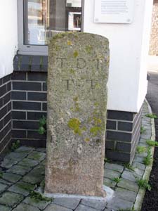
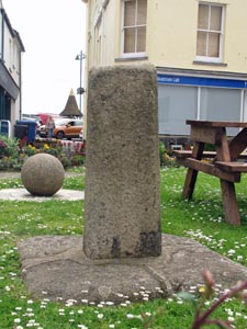
Stone Type: |
Boundary Stone |
|
|
|
|
|
Grid Reference: |
SX/9425/7303 |
|
|
|
|
|
Location: |
Outside the Information Office in Teignmouth Town Centre |
| |
|
|
|
|
Inscription: |
T D T T T (Teignmouth & Dawlish Turnpike Trust Terminus) |
|
|
|
|
|
|
|
|
Notes: |
See the note on Turnpike Trusts on the Home Page. |
| |
|
|
|
|
|
|
|
|
|
|
|
|
|
|
|
|
| |
|
|
|
|
|
|
|
|
|
|
|
|
|
|
|
|
|
|
|
|
|
|
|
|
|
|
|
|
|
|
|
|
|
|
|
|
|
|
|
|
|
|
|
|
|
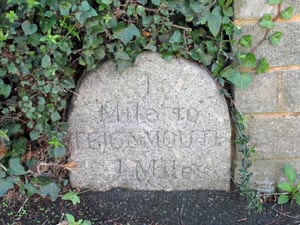
Stone Type: |
Milestone |
|
|
|
|
|
|
|
|
Grid Reference: |
SX/9495/7434 |
|
|
|
|
|
|
|
|
Location: |
On the South side of the A379 Teignmouth Road, opposite the entrance to
Holcombe Road |
|
|
|
|
|
|
|
|
Inscription: |
1 Mile to Teignmouth / 1 Mile. |
|
|
|
|
|
|
|
|
Notes: |
The second destination seems to buried beneath the tarmac, but is likely to
be 1 Mile to Dawlish. |
|
|
|
|
|
|
|
|
|
|
|
|
|
|
|
|
|
|
|
|
|
|
|
|
|
|
|
|
|
|
|
|
|
|
| |
|
|
|
|
|
|
|
|
|
|
|
|
|
|
|
|
| |
|
|
|
|
|
|
|
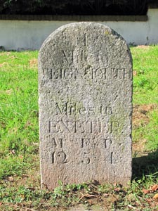
Stone Type: |
Milestone |
| |
|
|
|
|
|
|
|
Grid Reference: |
SX/9352/7453 |
| |
|
|
|
|
|
|
|
Location: |
Set into the grass verge on the West side of the B3192 Exeter Road,
Teignmouth, near the entrance to Raleigh Road. |
| |
|
|
|
|
|
|
|
Inscription: |
1 Mile to Teignmouth / Miles to Exeter 12M (Miles) 5F (Furlongs) 4P (Poles). |
| |
|
|
|
|
|
|
|
|
|
| |
|
|
|
|
|
|
|
|
|
|
|
|
|
|
|
|
|
|
|
|
|
|
|
|
|
|
|
|
|
|
|
|
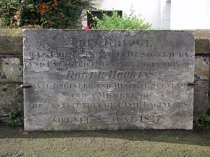
Stone Type: |
Bridge Plaque |
|
|
|
|
|
Grid Reference: |
SX/9306/7297 |
|
|
|
|
|
Location: |
On the western side of the Teignmouth-Shaldon Bridge, on the approach from
the Teignmouth side. |
|
|
|
|
|
|
|
|
Inscription: |
This bridge was projected and designed by and executed under the direction of
Roger Hopkins, Civil Engineer and Mineral Surveyor and a member of the
Institution of Civil Engineers. Opened 8th June 1827. |
|
|
|
|
|
|
|
|
|
|
|
|
|
|
|
|
|
|
|
|
|
|
|
|
| |
|
|
|
|
|
|
|
|
|
|
|
|
| |
|
|
|
|
|
|
|
|
|
|
|
|
|
|
|
|
|
|
|
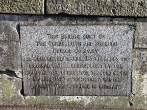
Stone Type: |
Bridge Plaque |
|
|
|
|
|
|
|
|
Grid Reference: |
SX/9308/7291 |
|
|
|
|
|
|
|
|
Location: |
On the eastern side of the Teignmouth-Shaldon Bridge, about 50 metres along
from the Teignmouth end of the bridge. |
|
|
|
|
|
|
|
|
Inscription: |
This bridge built by the Teignmouth and Shaldon Bridge Company and completed
in June 1932 replaces the original timber bridge built by the company and
opened for traffic on the 8th June 1827 at which time it was the longest
timber bridge in England. |
|
|
|
|
|
|
|
|
|
|
|
|
|
|
|
|
|
|
|
|
|
|
|
|
|
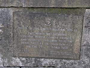
Stone Type: |
Bridge Plaque |
|
|
|
|
|
|
|
|
Grid Reference: |
SX/9307/7291 |
|
|
|
|
|
|
|
|
Location: |
On the western side of the Teignmouth-Shaldon Bridge, about 50 metres along
from the Teignmouth end of the bridge. |
|
|
|
|
|
|
|
|
Inscription: |
Teignmouth & Shaldon Bridge. This bridge was acquired by the Devon County
Council and formally declared to be free of tolls by Sir John Daw J.P.C.A.
on the 28th October 1948. H.A.Davis, Clerk of the Council - Sir J.F. Shelley
Bart. J.P.C.A, Chairman of the Council. |
|
|
|
|
|
|
|
|
Notes: |
There is also a metal plaque beside this stone to record the
strengthening of the bridge in 2002. |
|
|
|
|
|
|
|
| |
|
|
|
|
|
|
|
|
|
|
|
|
|
|
|
|
|
|
|
|
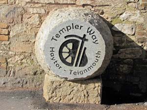
Stone Type: |
Boundary Stone |
|
|
|
|
|
|
|
|
Grid Reference: |
SX/9393/7271 |
|
|
|
|
|
|
|
|
Location: |
Set on a block against a wall opposite the Ship Inn on the New Quay,
Teignmouth. |
|
|
|
|
|
|
|
|
Inscription: |
Templer Way / Haytor - Teignmouth |
|
|
|
|
|
|
|
|
Notes: |
This stone was unveiled in October 2012 to mark the 25th Anniversary of the
Templer Way walking route from Haytor to Teignmouth. A similar stone
has been set up at the start of the walk at Haytor. |
|
|
|
|
|
|
|
|
|
|
|
|
|
|
|
|
|
|
|
|
|
|
|
|
|
|
|
|
|
|
|
|
|
|
|
|
|
|
|
|
|
|
|
|
|
|
|
|
|
|
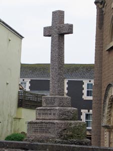
Stone Type: |
Churchyard
Cross |
|
|
|
|
|
|
|
|
|
Grid Reference: |
SX/943/730 |
|
|
|
|
|
|
|
|
|
Location: |
Above
the roadside wall at Teignmouth Churchyard |
|
|
|
|
|
|
|
|
|
Notes: |
The
cross serves as a War Memorial for World War I |
|
|
|
|
|
|
|
|
|
|
|
|
|
|
|
|
|
|
|
|
|
|
|
|
|
|
|
|
|
|
|
|
|
|
|
|
|
|
|
|
|
|
|
|
|
|
|
|
|
|
|
|
|
|
|
|
|
|
|
|
|
|
|
|
|
|
|
|
|
|
|
|
|
|
|
|
|
|
|
|
|
|
|
|
|
|
|
|
|
|
|
|
|
|
|
|
|
|
|
|
|
|
|
|
|
|
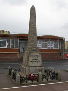
Stone Type: |
Town
Obelisk (Marker Stone) |
|
|
|
|
|
|
|
|
Grid Reference: |
SX/941/726 |
|
|
|
|
|
|
|
|
Location: |
On
the Teignmouth promenade, just to the south of the pier |
|
|
|
|
|
|
|
|
Notes: |
The
obelisk serves as the Town War Memorial (in addition to the Churchyard
Cross above). |
|
|
|
|
|
|
|
|
|
|
|
|
|
|
|
|
|
|
|
|
|
|
|
|
|
|
|
|
|
|
|
|
|
|
|
|
|
|
|
|
|
|
|
|
|
|
|
|
|
|
|
|
|
|
|
|
|
|
|
|
|
|
|
|
|
|
|
|
|
|
|
|
|
|
|
|
|
|
|
|
|
|
|
|
|
|
|
|
|
|
|
|
Stone Type: |
Cross |
|
|
|
|
|
|
|
|
|
Grid Reference: |
SX/9431/7298 |
|
|
|
|
|
|
|
|
|
Location: |
On
the raised area of grass in Regent Street, Teignmouth. |
|
|
|
|
|
|
|
|
|
Notes: |
This
is the remaining piece of shaft from the ancient Market Cross. |
|
|
|
|
|
|
|
|
|
|
|
|
|
|
|
|
|
|
|
|
|
|
|
|
|
|
|
|
|
|
|
|
|
|
|
|
|
|
|
|
|
|
|
|
|
|
|
|
|
|
|
|
|
|
|
|
|
|
|
|
|
|
|
|
|
|
|
|
|
|
|
|
|
|
|
|
|
|
|
|
|
|
|
|
|
|
|
|
|
|
|
|
|
|
|
|
|
|
|
|
|
|
|
|
|
|
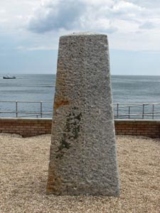
Stone Type: |
Obelisk
(Marker Stone) |
|
|
|
|
|
|
|
|
Grid Reference: |
SX/9404/7249 |
|
|
|
|
|
|
|
|
Location: |
Towards
the southern end of the Teignmouth Promenade. |
|
|
|
|
|
|
|
|
Notes: |
It
is thought that the original purpose of this obelisk was as a pedestal for
a lamppost, but before it could be put to that use it was placed to
support the ground around the lighthouse. |
|
|
|
|
|
|
|
|
|
|
|
|
|
|
|
|
|
|
|
|
|
|
|
|
|
|
|
|
|
|
|
|
|
|
|
|
|
|
|
|
|
|
|
|
|
|
|
|
|
|
|
|
|
|
|
|
|
|
|
|
|
|
|
|
|
|
|
|
|
|
|
|
|
|
|
|
|
|
|
|
|
|
|
|
|
|
|
|
|
|
|
|
|
|
|
|
|
| |
|
|
|
|
|
|
|
|
|
|
|
|
|
|
|
|
|
|
|
|
|
|
|
|
|
|
|
|
|
|
|
|
|
|
|
|
|
|
|