|
Devon Marker Stones |

![]()
|
|||||||||||||||||||||
 |
 |
 |
 |
 |
 |
 |
 |
 |
 |
 |
 |
 |
|
||||||||||||||||||||||||||||||||||||||||||
| District: | Torbay |
|
||||||||||||||||||||||||||||||||||||||||
| Parish: | Brixham |
|
||||||||||||||||||||||||||||||||||||||||
|
|
|||||||||||||||||||||||||||||||||||||||||
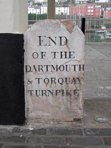
| Stone Type: | Boundary Stone | |||||||||||||||||||||||||||||||||||||||||
| Grid Reference: | SX/9255/5630 | |||||||||||||||||||||||||||||||||||||||||
| Location: | Beside a support post for the Boat Builders shelter on Brixham Harbour. | |||||||||||||||||||||||||||||||||||||||||
| Inscription: | End of the Dartmouth & Torquay Turnpike | |||||||||||||||||||||||||||||||||||||||||
| Notes: | See note on Turnpike Trusts on the Home Page. | |||||||||||||||||||||||||||||||||||||||||
|
||||||||||||||||||||||||||||||||||||||||||
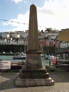
| Stone Type: | William of Orange Marker Stone | |||||||||||||||||||||||||||||||||||||||||
| Grid Reference: | SX/9256/5632 | |||||||||||||||||||||||||||||||||||||||||
| Location: | A few metres to the left of the Boat Builders shelter on Brixham Harbour. | |||||||||||||||||||||||||||||||||||||||||
| Inscription: | On this Stone and near this Spot William Prince of Orange First set Foot on his Landing in England 5th November 1688. | |||||||||||||||||||||||||||||||||||||||||
|
||||||||||||||||||||||||||||||||||||||||||
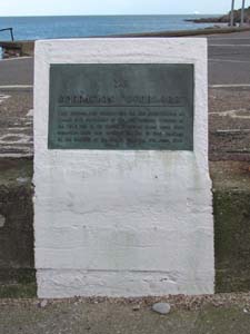
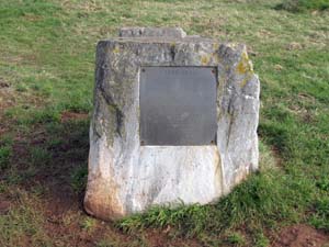
| Stone Type: | Operation Overlord Marker Stone | |||||||||||||||||||||||||||||||||||||||||
| Grid Reference: | SX/931/566 | |||||||||||||||||||||||||||||||||||||||||
| Location: | At the slipway on the southern end of the Brixham Breakwater. | |||||||||||||||||||||||||||||||||||||||||
| Notes: | The plaque records the building of the slipway for the D-Day Landings (Operation Overlord), which took place in June 1944. | |||||||||||||||||||||||||||||||||||||||||
|
||||||||||||||||||||||||||||||||||||||||||
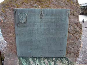
| Stone Type: | Brixham Breakwater Marker Stone | |||||||||||||||||||||||||||||||||||||||||
| Grid Reference: | SX/9314/5665 | |||||||||||||||||||||||||||||||||||||||||
| Location: | At the southern end of the Brixham Breakwater. | |||||||||||||||||||||||||||||||||||||||||
| Notes: | The plaque records the building of the breakwater in 1843 and its subsequent history. | |||||||||||||||||||||||||||||||||||||||||
|
||||||||||||||||||||||||||||||||||||||||||
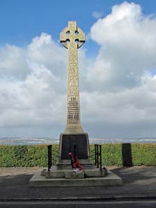
| Stone Type: | War Memorial Cross | |||||||||||||||||||||||||||||||||||||||||
| Grid Reference: | SX/9301/5651 | |||||||||||||||||||||||||||||||||||||||||
| Location: | On an area of grass overlooking Brixham Harbour | |||||||||||||||||||||||||||||||||||||||||
| Inscription: | In Grateful Remembrance of our Heroic Fellow Citizens who Sacrificed their Lives in the World Wars 1914-1919 / 1939-1945 Their Name Liveth for Evermore | |||||||||||||||||||||||||||||||||||||||||
|
||||||||||||||||||||||||||||||||||||||||||
| Stone Type: | Berry Head Marker Stone | |||||||||||||||||||||||||||||||||||||||||
| Grid Reference: | SX/9417/5637 | |||||||||||||||||||||||||||||||||||||||||
| Location: | Beside the track that runs between the two forts at Berry Head. | |||||||||||||||||||||||||||||||||||||||||
| Notes: | The plaque, which is now badly worn and difficult to decipher, records the importance of Berry Head as a nature reserve. | |||||||||||||||||||||||||||||||||||||||||
|
||||||||||||||||||||||||||||||||||||||||||
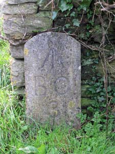
| Stone Type: | Boundary Stone | |||||||||||||||||||||||||||||||||||||||||
| Grid Reference: | SX/9401/5615 | |||||||||||||||||||||||||||||||||||||||||
| Location: | On the bend in the road, at the turn off point to the Berry Head Car Park. | |||||||||||||||||||||||||||||||||||||||||
| Inscription: | B O 3 (Board of Ordnance No.3) | |||||||||||||||||||||||||||||||||||||||||
| Notes: | Boundary Stone to mark the limit of the military area at Berry Head. The stone also shows an Ordnance Survey benchmark. | |||||||||||||||||||||||||||||||||||||||||
|
||||||||||||||||||||||||||||||||||||||||||
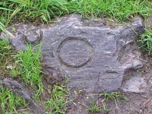
| Stone Type: | Boundary Stone | |||||||||||||||||||||||||||||||||||||||||
| Grid Reference: | SX/9389/5607 | |||||||||||||||||||||||||||||||||||||||||
| Location: | On the south side of the road leading to Berry Head, to the south west of the car park. | |||||||||||||||||||||||||||||||||||||||||
| Inscription: | O - (Ordnance) | |||||||||||||||||||||||||||||||||||||||||
| Notes: | Boundary Stone to mark the limit of the military area at Berry Head. Although not now showing there would originally have been a 'B' and a sequence number (Board of Ordnance No. ?). | |||||||||||||||||||||||||||||||||||||||||
|
||||||||||||||||||||||||||||||||||||||||||
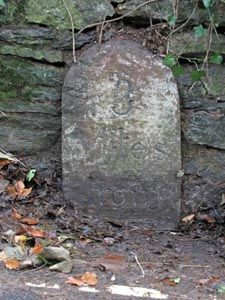
| Stone Type: | Milestone | |||||||||||||||||||||||||||||||||||||||||
| Grid Reference: | SX/9118/5446 | |||||||||||||||||||||||||||||||||||||||||
| Location: | Set into the stone wall on the north west side of Milton Street, Brixham. | |||||||||||||||||||||||||||||||||||||||||
| Inscription: | 3 Miles From | |||||||||||||||||||||||||||||||||||||||||
| Notes: | Although the destination is now buried beneath the road surface, the stone probably reads: '3 Miles From Dartmouth'. | |||||||||||||||||||||||||||||||||||||||||
|
||||||||||||||||||||||||||||||||||||||||||
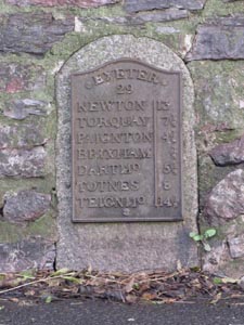
| Stone Type: | Milestone | |||||||||||||||||||||||||||||||||||||||||
| Grid Reference: | SX/9131/5544 | |||||||||||||||||||||||||||||||||||||||||
| Location: | Built into the stone wall on the north side of the A3022, about 150 metres to the west of the Monksbridge Toll House. | |||||||||||||||||||||||||||||||||||||||||
| Inscription: | Exeter 29; Newton 13; Torquay 7¼; Paignton 4½; Brixham ¾; Dartmo (Dartmouth) 5¼; Totnes 8; Teignmo (Teignmouth) 14¾; | |||||||||||||||||||||||||||||||||||||||||
|
||||||||||||||||||||||||||||||||||||||||||
| Stone Type: | Boundary Stone | |||||||||||||||||||||||||||||||||||||||||
| Grid Reference: | SX/9106/5545 | |||||||||||||||||||||||||||||||||||||||||
| Location: | On the grass verge, on the north side of the A3022 and behind the Brixham sign. | |||||||||||||||||||||||||||||||||||||||||
| Inscription: | Brixham | |||||||||||||||||||||||||||||||||||||||||
| Notes: | The stone shares it's boundary with Churston Ferrers. | |||||||||||||||||||||||||||||||||||||||||
|
||||||||||||||||||||||||||||||||||||||||||
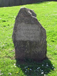
| Stone Type: | Marker Stone | |||||||||||||||||||||||||||||||||||||||||
| Grid Reference: | SX/9185/5579 | |||||||||||||||||||||||||||||||||||||||||
| Location: | On the grass verge at the Junction of New Road with Cudhill Road | |||||||||||||||||||||||||||||||||||||||||
| Inscription: | Soroptimist International Brixham 50th Year 1998. | |||||||||||||||||||||||||||||||||||||||||
|
||||||||||||||||||||||||||||||||||||||||||
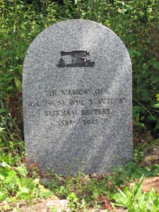
| Stone Type: | Memorial Marker Stone | |||||||||||||||||||||||||||||||||||||||||
| Grid Reference: | SX/9197/5678 | |||||||||||||||||||||||||||||||||||||||||
| Location: | On the verge outside the Brixham Battery Museum | |||||||||||||||||||||||||||||||||||||||||
| Inscription: | In Memory of all those who Survived at Brixham Battery 1588 - 1945 | |||||||||||||||||||||||||||||||||||||||||