|
Devon Marker Stones |

|
|||||||||||||||||||||
 |
 |
 |
 |
 |
 |
 |
 |
 |
|
||||||||||||||||||||||||||||||||||||||||||
| District: | West Devon |
|
||||||||||||||||||||||||||||||||||||||||
| Parish: | Drewsteignton | |||||||||||||||||||||||||||||||||||||||||
|
|
|||||||||||||||||||||||||||||||||||||||||
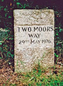
| Stone Type: | Marker Stone | |||||||||||||||||||||||||||||||||||||||||
| Grid Reference: | SX/7344/9080 | |||||||||||||||||||||||||||||||||||||||||
| Location: | At the entrance to the footpath leading from Drewsteignton village to Sharp Tor on Piddledown Common. | |||||||||||||||||||||||||||||||||||||||||
| Inscription: | Two Moors Way 29th May 1976 | |||||||||||||||||||||||||||||||||||||||||
|
||||||||||||||||||||||||||||||||||||||||||
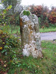
| Stone Type: | Marker Stone | |||||||||||||||||||||||||||||||||||||||||
| Grid Reference: | SX/7419/8880 | |||||||||||||||||||||||||||||||||||||||||
| Location: | On the vegetation covered triangle formed by the junction of the footpath from Cranbrook Castle with the minor road from Clifford Bridge to Chagford. | |||||||||||||||||||||||||||||||||||||||||
| Inscription: | D T / C / M / E (Drewsteignton / Chagford / Moretonhampstead / Exeter) | |||||||||||||||||||||||||||||||||||||||||
|
||||||||||||||||||||||||||||||||||||||||||
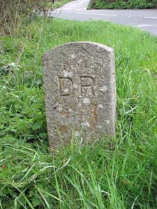
| Stone Type: | Boundary Stone | |||||||||||||||||||||||||||||||||||||||||
| Grid Reference: | SX/6978/9026 | |||||||||||||||||||||||||||||||||||||||||
| Location: | On the eastern side of the A382, just a few metres from the crossroads with the minor road from Drewsteignton to Murchington. | |||||||||||||||||||||||||||||||||||||||||
| Inscription: | D R / T / 2000 AD / C (Drewsteignton / Throwleigh / Millennium / Chagford). | |||||||||||||||||||||||||||||||||||||||||
| Notes: | This stone was erected as a millennium boundary stone. | |||||||||||||||||||||||||||||||||||||||||
|
||||||||||||||||||||||||||||||||||||||||||
| Stone Type: | Milestone | |||||||||||||||||||||||||||||||||||||||||
| Grid Reference: | SX/7166/9238 | |||||||||||||||||||||||||||||||||||||||||
| Location: | In the lay-by on the west bound carriageway of the A30, about 2 kilometres east of the Whiddon Down junction. | |||||||||||||||||||||||||||||||||||||||||
| Inscription: | Okehampton 9 Miles. | |||||||||||||||||||||||||||||||||||||||||
|
||||||||||||||||||||||||||||||||||||||||||
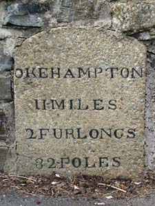
| Stone Type: | Milestone | |||||||||||||||||||||||||||||||||||||||||
| Grid Reference: | SX/7534/9240 | |||||||||||||||||||||||||||||||||||||||||
| Location: | Set back against the roadside wall in the centre of Crockernwell. | |||||||||||||||||||||||||||||||||||||||||
| Inscription: | Okehampton 11 Miles - 2 Furlongs - 32 Poles | |||||||||||||||||||||||||||||||||||||||||
| Notes: | This is the left-hand stone of three in a row. | |||||||||||||||||||||||||||||||||||||||||
|
||||||||||||||||||||||||||||||||||||||||||
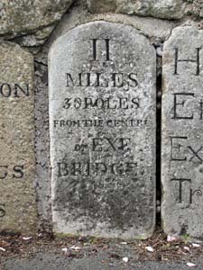
| Stone Type: | Milestone | |||||||||||||||||||||||||||||||||||||||||
| Grid Reference: | SX/7535/9240 | |||||||||||||||||||||||||||||||||||||||||
| Location: | Set back against the roadside wall in the centre of Crockernwell. | |||||||||||||||||||||||||||||||||||||||||
| Inscription: | 11 Miles - 38 Poles From the Centre of Exe Bridge | |||||||||||||||||||||||||||||||||||||||||
| Notes: | This is the centre stone of three in a row. | |||||||||||||||||||||||||||||||||||||||||
|
||||||||||||||||||||||||||||||||||||||||||
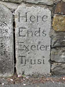
| Stone Type: | Turnpike Trust Marker Stone | |||||||||||||||||||||||||||||||||||||||||
| Grid Reference: | SX/7535/9240 | |||||||||||||||||||||||||||||||||||||||||
| Location: | Set back against the roadside wall in the centre of Crockernwell. | |||||||||||||||||||||||||||||||||||||||||
| Inscription: | Here Ends Exeter Trust | |||||||||||||||||||||||||||||||||||||||||
| Notes: | This is the right-hand stone of three in a row. See also note on Turnpike Trusts on the Home Page. | |||||||||||||||||||||||||||||||||||||||||
|
||||||||||||||||||||||||||||||||||||||||||
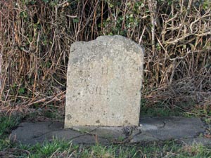
| Stone Type: | Milestone | |||||||||||||||||||||||||||||||||||||||||
| Grid Reference: | SX/7480/9233 | |||||||||||||||||||||||||||||||||||||||||
| Location: | On the grass verge to the north side of the road and about 0.3 miles to the west of Crockernwell. | |||||||||||||||||||||||||||||||||||||||||
| Inscription: | Okehampton 11 Miles | |||||||||||||||||||||||||||||||||||||||||
|
||||||||||||||||||||||||||||||||||||||||||
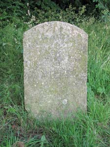
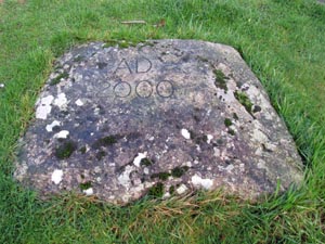
| Stone Type: | Millennium Marker Stone | |||||||||||||||||||||||||||||||||||||||||
| Grid Reference: | SX/7357/9018 | |||||||||||||||||||||||||||||||||||||||||
| Location: | On the village green, south of the Square. | |||||||||||||||||||||||||||||||||||||||||
| Inscription: | AD 2000 | |||||||||||||||||||||||||||||||||||||||||