| |
|
|
|
|
|
|
|
|
|
|
|
|
| |
|
|
|
|
|
|
|
|
|
|
|
|
|
|
|
|
|
|
|
|
District: |
West Devon |
|
|
|
|
|
|
|
|
|
|
|
 |
|
| |
|
|
|
|
|
|
|
|
|
|
|
|
|
|
|
|
|
|
Parish: |
Okehampton |
 |
 |
 |
|
|
|
|
| |
|
|
|
|
|
|
|
|
|
|
|
|
|
|
|
|
|
|
|
| |
|
|
|
|
|
|
|
|
|
|
|
|
|
|
|
|
|
|
|
| |
|
|
|
|
|
|
|
|
|
|
|
|
|
|
|
|
|
|
|
| Page
Contents: |
|
| |
17 Boundary Stones |
| |
4 Crosses |
| |
13 Marker Stones |
| |
3 Milestones |
| |
|
| |
|
|
|
|
|
|
|
|
|
|
|
|
|
|
|
|
|
|
| |
|
|
|
|
|
|
|
|
|
|
|
|
|
| |
|
|
|
|
|
|
|
|
|
|
|
|
|
| |
|
|
|
|
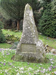
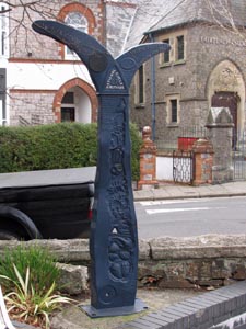
Stone Type: |
Simmons Park Marker Stone |
| |
|
|
|
|
Grid Reference: |
SX/588/949 |
| |
|
|
|
|
Location: |
On the right, a few metres inside the main entrance to Okehampton Simmons
Park. |
| |
|
|
|
|
Inscription: |
This park Presented by Sydney Simmons of Okehampton North Finchley was
opened July 8th 1907 by the Right Hon. Sir W.P. Treloar Lord Mayor of
London. |
| |
|
|
|
|
|
|
|
|
|
| |
|
|
|
|
|
|
|
|
|
|
|
|
|
|
|
|
| |
|
|
|
|
|
|
|
|
|
|
|
|
|
|
|
|
| |
|
|
|
|
|
|
|
|
|
|
|
|
|
|
|
|
|
|
|
|
|
|
|
|
|
|
|
|
|
|
|
|
| |
|
|
|
|
|
|
|
|
|
|
|
|
|
|
|
|
| |
|
|
|
|
|
|
|
|
|
|
|
|
|
|
|
|
|
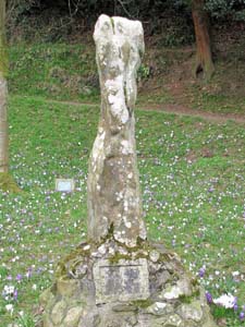
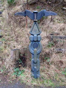
Stone Type: |
Jubilee Bridge Marker Stone (Simmons Park) |
|
|
|
|
|
|
|
|
|
Grid Reference: |
SX/590/946 |
|
|
|
|
|
|
|
|
|
Location: |
Simmons Park, opposite the western end of the Jubilee Bridge into the car
park. |
|
|
|
|
|
|
|
|
|
Inscription: |
1907 - 1957 Jubilee Bridge |
|
|
|
|
|
|
|
|
| |
|
|
|
|
|
|
|
|
|
| |
|
|
|
|
|
|
|
|
|
|
|
|
|
|
|
|
| |
|
|
|
|
|
|
|
|
|
|
|
|
|
|
|
|
| |
|
|
|
|
|
|
|
|
|
|
|
|
|
|
| |
|
|
|
|
|
|
|
|
|
|
|
|
|
| |
|
|
|
|
|
|
|
|
|
|
|
|
|
|
|
|
| |
|
|
|
|
|
|
|
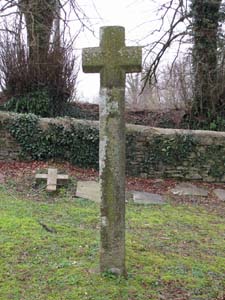
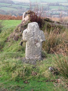
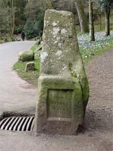
Stone Type: |
Okehampton Churchyard (Wayside) Cross |
| |
|
|
|
|
|
|
|
Grid Reference: |
SX/5813/9508 |
| |
|
|
|
|
|
|
|
Location: |
Just inside the west gate to the Okehampton Churchyard. |
| |
|
|
|
|
|
|
|
Notes: |
The cross has been brought into the churchyard for safekeeping. |
| |
|
|
|
|
|
|
|
|
|
| |
|
|
|
|
|
|
|
|
|
|
|
|
|
|
|
|
| |
|
|
|
|
|
|
|
|
|
|
|
|
|
|
|
|
|
|
|
|
|
|
|
|
|
|
|
|
|
|
|
|
| |
|
|
|
|
|
|
|
|
|
|
|
|
|
| |
|
|
|
|
|
|
|
|
|
|
|
|
|
|
|
|
|
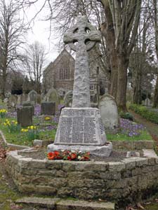
Stone Type: |
Memorial Churchyard Cross |
|
|
|
|
|
|
|
|
|
Grid Reference: |
SX/5825/9512 |
|
|
|
|
|
|
|
|
|
Location: |
Just inside the east gate to the Okehampton Churchyard. |
|
|
|
|
|
|
|
|
|
Notes: |
The cross serves as the Town's War Memorial. |
|
|
|
|
|
|
|
|
| |
|
|
|
|
|
|
|
|
|
| |
|
|
|
|
|
|
|
|
|
|
|
|
|
|
|
|
| |
|
|
|
|
|
|
|
|
|
|
|
|
|
|
|
|
| |
|
|
|
|
|
|
|
|
|
|
|
|
|
|
| |
|
|
|
|
|
|
|
|
|
|
|
|
|
| |
|
|
|
|
|
|
|
|
|
|
|
|
|
|
|
|
| |
|
|
|
|
|
|
|
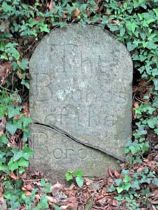
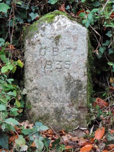
Stone Type: |
Boundary Stone |
| |
|
|
|
|
|
|
|
Grid Reference: |
SX/5840/9443 |
| |
|
|
|
|
|
|
|
Location: |
Tight against the hedge, on the north west side of the B3260 going up the
hill out of Okehampton. |
| |
|
|
|
|
|
|
|
Inscription: |
The Bounds of the Borough (Okehampton Boundary) |
| |
|
|
|
|
|
|
|
|
|
| |
|
|
|
|
|
|
|
|
|
|
|
|
|
|
|
|
| |
|
|
|
|
|
|
|
|
|
|
|
|
|
|
|
|
|
|
|
|
|
|
|
|
|
|
|
|
|
|
|
|
| |
|
|
|
|
|
|
|
|
|
|
|
|
|
| |
|
|
|
|
|
|
|
|
|
|
|
|
|
|
|
|
|
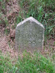
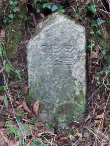
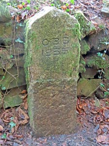
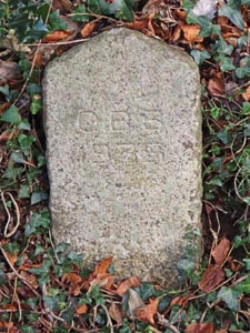
Stone Type: |
Boundary Stone |
|
|
|
|
|
|
|
|
|
Grid Reference: |
SX/6010/9542 |
|
|
|
|
|
|
|
|
|
Location: |
On the grass verge, on the northern side of the B3260 towards the eastern
outskirts of Okehampton. |
|
|
|
|
|
|
|
|
|
Inscription: |
O.B.B. 1935 (Okehampton Borough Bounds 1935) |
|
|
|
|
|
|
|
|
| |
|
|
|
|
|
|
|
|
|
| |
|
|
|
|
|
|
|
|
|
|
|
|
|
|
|
|
| |
|
|
|
|
|
|
|
|
|
|
|
|
|
|
|
|
| |
|
|
|
|
|
|
|
|
|
|
|
|
|
|
| |
|
|
|
|
|
|
|
|
|
|
|
|
|
| |
|
|
|
|
|
|
|
|
|
|
|
|
|
|
|
|
| |
|
|
|
|
|
|
|
Stone Type: |
Milestone |
| |
|
|
|
|
|
|
|
Grid Reference: |
SX/6030/9540 |
| |
|
|
|
|
|
|
|
Location: |
On the grass verge, on the northern side of the B3260 towards the eastern
outskirts of Okehampton. |
| |
|
|
|
|
|
|
|
Inscription: |
Okehampton 1 Mile |
| |
|
|
|
|
|
|
|
Notes: |
The inscription has become eroded and is now barely visible. |
| |
|
|
|
|
|
|
|
|
|
|
|
|
|
|
|
|
| |
|
|
|
|
|
|
|
|
|
|
|
|
|
|
|
|
|
|
|
|
|
|
|
|
|
|
|
|
|
|
|
|
| |
|
|
|
|
|
|
|
|
|
|
|
|
|
| |
|
|
|
|
|
|
|
|
|
|
|
|
|
|
|
|
|
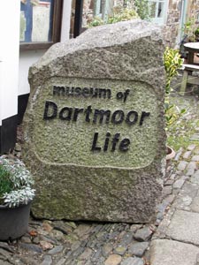
Stone Type: |
Marker Stone |
|
|
|
|
|
|
|
|
|
Grid Reference: |
SX/5873/9517 |
|
|
|
|
|
|
|
|
|
Location: |
Outside the entrance to the Museum of Dartmoor Life, Okehampton. |
|
|
|
|
|
|
|
|
|
Inscription: |
Museum of Dartmoor Life |
|
|
|
|
|
|
|
|
|
|
|
|
|
|
|
|
|
|
| |
|
|
|
|
|
|
|
|
|
|
|
|
|
|
|
|
| |
|
|
|
|
|
|
|
|
|
|
|
|
|
|
|
|
| |
|
|
|
|
|
|
|
|
|
|
|
|
|
|
| |
|
|
|
|
|
|
|
|
|
|
|
|
|
| |
|
|
|
|
|
|
|
|
|
|
|
|
|
|
|
|
| |
|
|
|
|
|
|
|
Stone Type: |
Fitz's Well Cross |
| |
|
|
|
|
|
|
|
Grid Reference: |
SX/5919/9378 |
| |
|
|
|
|
|
|
|
Location: |
On open ground, about 20 metres west of the road from Okehampton to the
Military Camp. |
| |
|
|
|
|
|
|
|
Notes: |
The cross is named after the 16th century Tavistock Lawyer Sir John Fitz,
who probably erected this cross here on this site. |
| |
|
|
|
|
|
|
|
|
|
| |
|
|
|
|
|
|
|
|
|
|
|
|
|
|
|
|
| |
|
|
|
|
|
|
|
|
|
|
|
|
|
|
|
|
|
|
|
|
|
|
|
|
|
|
|
|
|
|
|
|
| |
|
|
|
|
|
|
|
|
|
|
|
|
|
| |
|
|
|
|
|
|
|
|
|
|
|
|
|
|
|
|
|
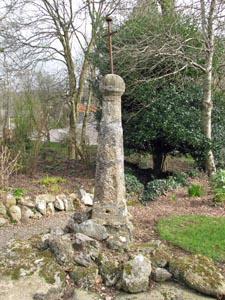
Stone Type: |
Boundary Stone |
|
|
|
|
|
|
|
|
|
Grid Reference: |
SX/5799/9559 |
|
|
|
|
|
|
|
|
|
Location: |
Set into the bank to the left of the entrance to 'Cornhill' on Old
Hatherleigh Road, Okehampton. |
|
|
|
|
|
|
|
|
|
Notes: |
The stone has been severely damaged and the inscription is now missing. |
|
|
|
|
|
|
|
|
| |
|
|
|
|
|
|
|
|
|
| |
|
|
|
|
|
|
|
|
|
|
|
|
|
|
|
|
| |
|
|
|
|
|
|
|
|
|
|
|
|
|
|
|
|
| |
|
|
|
|
|
|
|
|
|
|
|
|
|
| |
|
|
|
|
|
|
|
|
|
|
|
|
| |
|
|
|
|
|
|
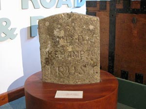
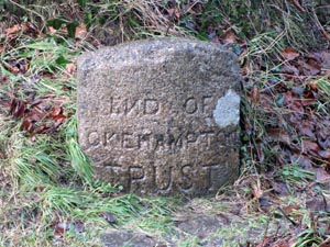
Stone Type: |
Turnpike Boundary Stone |
| |
|
|
|
|
|
|
Grid Reference: |
SX/587/951 |
| |
|
|
|
|
|
|
Location: |
On display in the Museum of Dartmoor Life, Okehampton. |
| |
|
|
|
|
|
|
Inscription: |
End of Okehampton Trust. |
| |
|
|
|
|
|
|
Notes: |
The stone was originally sited 800 yards
to the north of Goldburn Cross, on the Okehampton to Jacobstowe Road - Grid
Ref: SX592/990. (See notes on Home Page for details of Turnpike Trusts). |
|
|
|
|
|
|
|
|
| |
|
|
|
|
|
|
|
|
|
|
|
|
| |
|
|
|
|
|
|
|
|
|
|
|
|
|
|
|
|
|
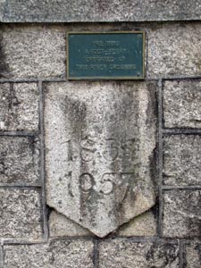
Stone Type: |
Bridge
Marker Stone |
|
|
|
|
|
|
|
|
|
Grid Reference: |
SX/5867/9517 |
|
|
|
|
|
|
|
|
|
Location: |
Built
into the east end of the northern parapet of the bridge over the West
Okement River |
|
|
|
|
|
|
|
|
|
Inscription: |
1834
/ 1957 |
|
|
|
|
|
|
|
|
| |
|
|
|
|
|
|
|
|
|
| |
|
|
|
|
|
|
|
|
|
|
|
|
|
|
|
|
| |
|
|
|
|
|
|
|
|
|
|
|
|
|
|
|
|
| |
|
|
|
|
|
|
|
|
|
|
|
|
|
|
| |
|
|
|
|
|
|
|
|
|
|
|
|
|
| |
|
|
|
|
|
|
|
|
|
|
|
|
|
|
|
|
| |
|
|
|
|
|
|
|
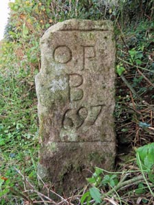
Stone Type: |
Boundary Stone |
| |
|
|
|
|
|
|
|
Grid Reference: |
SX/6099/9665 |
| |
|
|
|
|
|
|
|
Location: |
At the back of the lay-by on the B3215 at Glendon Cross, Okehampton. |
| |
|
|
|
|
|
|
|
Inscription: |
O P B 1697 (Okehampton Parish Boundary). |
| |
|
|
|
|
|
|
|
Notes: |
The stone shares its boundary with Sampford Courtenay. |
| |
|
|
|
|
|
|
|
|
|
|
|
|
|
|
|
|
| |
|
|
|
|
|
|
|
|
|
|
|
|
|
|
|
|
|
|
|
|
|
|
|
|
|
|
|
|
|
|
|
|
| |
|
|
|
|
|
|
|
|
|
|
|
|
|
| |
|
|
|
|
|
|
|
|
|
|
|
|
|
|
|
|
|
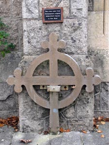
Stone Type: |
Church
Cross |
|
|
|
|
|
|
|
|
|
Grid Reference: |
SX/5881/9505 |
|
|
|
|
|
|
|
|
|
Location: |
Against
the wall of the Fairplace United Church. |
|
|
|
|
|
|
|
|
| Notes: |
The
cross came from Okehampton's original Weslyan Church in New Road. |
|
|
|
|
|
|
|
|
|
|
|
|
|
|
|
|
|
|
| |
|
|
|
|
|
|
|
|
|
|
|
|
|
|
|
|
| |
|
|
|
|
|
|
|
|
|
|
|
|
|
|
|
|
|
|
|
|
|
|
|
|
|
|
|
|
|
|
|
|
|
|
|
|
|
|
|
|
|
|
|
|
|
|
|
|
|
|
|
|
|
|
|
|
|
|
|
|
|
|
|
|
|
|
|
|
|
|
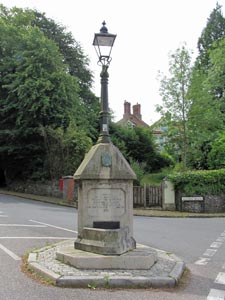
Stone
Type: |
Marker
Stone |
|
|
|
|
|
|
|
|
Grid
Reference: |
SX/587/943 |
|
|
|
|
|
|
|
|
Location: |
At
the junction of Station Road with Tors Road. |
|
|
|
|
|
|
|
|
Notes: |
A
memorial to William Trevor Roper and Marion Luxmore, which also supports a
street lamp. |
|
|
|
|
|
|
|
|
|
|
|
|
|
|
|
|
|
|
|
|
|
|
|
|
|
|
|
|
|
|
|
|
|
|
|
|
|
|
|
|
|
|
|
|
|
|
|
|
|
|
|
|
|
|
|
|
|
|
|
|
|
|
|
|
|
|
|
|
|
|
|
|
|
|
|
|
|
|
|
|
|
|
|
|
|
|
|
|
|
|
|
|
Stone Type: |
Marker
Stone |
|
|
|
|
|
|
|
|
|
Grid Reference: |
SX/588/947 |
|
|
|
|
|
|
|
|
|
Location: |
Simmons
Park, Okehampton |
|
|
|
|
|
|
|
|
| Notes: |
This
stone was once a pinnacle on St James' Church, Okehampton. |
|
|
|
|
|
|
|
|
|
|
|
|
|
|
|
|
|
|
|
|
|
|
|
|
|
|
|
|
|
|
|
|
|
|
|
|
|
|
|
|
|
|
|
|
|
|
|
|
|
|
|
|
|
|
|
|
|
|
|
|
|
|
|
|
|
|
|
|
|
|
|
|
|
|
|
|
|
|
|
|
|
|
|
|
|
|
|
|
|
|
|
|
|
|
|
|
|
|
|
|
|
|
|
|
|
|
Stone Type: |
Milestone |
|
|
|
|
|
|
|
|
Grid Reference: |
SX/5880/9507 |
|
|
|
|
|
|
|
|
Location: |
St
James Street, In
the Centre of Okehampton. |
|
|
|
|
|
|
|
|
Inscription: |
52M
Ilfracombe / Meldon Viaduct 2½M / Plymouth Hoe 38M |
|
|
|
|
|
|
|
|
Notes: |
The
milestone was sponsored by the Royal Bank of Scotland. |
|
|
|
|
|
|
|
|
|
|
|
|
|
|
|
|
|
|
|
|
|
|
|
|
|
|
|
|
|
|
|
|
|
|
|
|
|
|
|
|
|
|
|
|
|
|
|
|
|
|
|
|
|
|
|
|
|
|
|
|
|
|
|
|
|
|
|
|
|
|
|
|
|
|
|
|
|
|
|
|
|
|
Stone Type: |
Milestone |
|
|
|
|
|
|
|
|
|
Grid Reference: |
SX/5761/9353 |
|
|
|
|
|
|
|
|
|
Location: |
On
the Granite Way between Okehampton and Lydford. |
|
|
|
|
|
|
|
|
|
Inscription: |
1½M
Okehampton / 1¼M Station / Meldon 1½M / Station 1M. |
|
|
|
|
|
|
|
|
| Notes: |
The
milestone was sponsored by the Royal Bank of Scotland. |
|
|
|
|
|
|
|
|
|
|
|
|
|
|
|
|
|
|
|
|
|
|
|
|
|
|
|
|
|
|
|
|
|
|
|
|
|
|
|
|
|
|
|
|
|
|
|
|
|
|
|
|
|
|
|
|
|
|
|
|
|
|
|
|
|
|
|
|
|
|
|
|
|
|
|
|
|
|
|
|
|
|
|
|
|
|
|
|
|
|
|
|
|
|
|
|
Stone Type: |
Marker
Stone |
|
|
|
|
|
|
|
|
Grid Reference: |
SX/588/947 |
|
|
|
|
|
|
|
|
Location: |
Simmons
Park, Okehampton |
|
|
|
|
|
|
|
|
Inscription: |
The
Mayor's Walk |
|
|
|
|
|
|
|
|
|
|
|
|
|
|
|
|
|
|
|
|
|
|
|
|
|
|
|
|
|
|
|
|
|
|
|
|
|
|
|
|
|
|
|
|
|
|
|
|
|
|
|
|
|
|
|
|
|
|
|
|
|
|
|
|
|
|
|
|
|
|
|
|
|
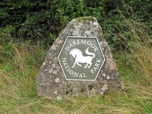
Stone Type: |
Boundary
Stone |
|
|
|
|
|
|
|
|
Grid Reference: |
SX/5905/9404 |
|
|
|
|
|
|
|
|
Location: |
On
the grass verge to the south of the road, below Klondyke Corner. |
|
|
|
|
|
|
|
|
Inscription: |
Dartmoor
National Park |
|
|
|
|
|
|
|
|
|
|
|
|
|
|
|
|
|
|
|
|
|
|
|
|
|
|
|
|
|
|
|
|
|
|
|
|
|
|
|
|
|
|
|
|
|
|
|
|
|
|
|
|
|
|
|
|
|
|
|
|
|
|
|
|
|
|
|
|
|
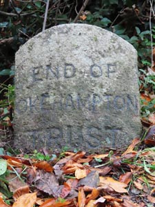
Stone Type: |
Boundary
Stone |
|
|
|
|
|
|
|
Grid Reference: |
SX/5324/9401 |
|
|
|
|
|
|
|
Location: |
On
the north side of the A3079, 150 yards east of Thorndon Cross. |
|
|
|
|
|
|
|
Inscription: |
End
of Okehampton Trust |
|
|
|
|
|
|
|
Notes: |
Further
details on Turnpike Trusts are shown on the Home Page. |
|
|
|
|
|
|
|
|
|
|
|
|
|
|
|
|
|
|
|
|
|
|
|
|
|
|
|
|
|
|
|
|
|
|
|
|
|
|
|
|
|
|
|
|
|
|
|
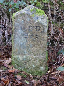
Stone Type: |
Boundary
Stone |
|
|
|
|
|
|
|
|
|
Grid Reference: |
SX/5976/9613 |
|
|
|
|
|
|
|
|
|
Location: |
Tucked
back under the hedge in a disused gateway. |
|
|
|
|
|
|
|
|
|
Inscription: |
OBB
1935 (Okehampton Borough Bounds 1935) |
|
|
|
|
|
|
|
|
|
|
|
|
|
|
|
|
|
|
|
|
|
|
|
|
|
|
|
|
|
|
|
|
|
|
|
|
|
|
|
|
|
|
|
|
|
|
|
|
|
|
|
|
|
|
|
|
|
|
|
|
|
|
|
|
|
|
|
|
|
|
|
|
|
|
|
|
|
|
|
|
|
|
|
|
|
|
|
|
|
|
|
|
|
|
|
|
|
|
|
|
|
|
|
|
|
|
Stone Type: |
Boundary
Stone |
|
|
|
|
|
|
|
|
Grid Reference: |
SX/6002/9768 |
|
|
|
|
|
|
|
|
Location: |
Beside
the northern end of the bridge parapet. |
|
|
|
|
|
|
|
|
Inscription: |
End
of Okehampton Trust |
|
|
|
|
|
|
|
|
Notes: |
Further
details on Turnpike Trusts are shown on the Home Page. |
|
|
|
|
|
|
|
|
|
|
|
|
|
|
|
|
|
|
|
|
|
|
|
|
|
|
|
|
|
|
|
|
|
|
|
|
|
|
|
|
|
|
|
|
|
|
|
|
|
|
|
|
|
|
|
|
|
|
|
|
|
|
|
|
|
|
|
|
|
|
|
|
|
|
|
|
|
|
|
|
|
|
Stone Type: |
Boundary
Stone |
|
|
|
|
|
|
|
|
|
Grid Reference: |
SX/5934/9630 |
|
|
|
|
|
|
|
|
|
Location: |
Beneath
the sign post at the Knowle road junction |
|
|
|
|
|
|
|
|
|
Inscription: |
OBB
1935 (Okehampton Borough Bounds 1935) |
|
|
|
|
|
|
|
|
|
|
|
|
|
|
|
|
|
|
|
|
|
|
|
|
|
|
|
|
|
|
|
|
|
|
|
|
|
|
|
|
|
|
|
|
|
|
|
|
|
|
|
|
|
|
|
|
|
|
|
|
|
|
|
|
|
|
|
|
|
|
|
|
|
|
|
|
|
|
|
|
|
|
|
|
|
|
|
|
|
|
|
|
|
|
|
|
|
|
|
|
|
|
|
|
|
|
Stone Type: |
Pig
Pen Marker Stone |
|
|
|
|
|
|
|
|
Grid Reference: |
SX/5886/9521 |
|
|
|
|
|
|
|
|
Location: |
Behind
the Fore Street Church, in the centre of Okehampton. |
|
|
|
|
|
|
|
|
Inscription: |
In
medieval times a pig pen occupied this site. In daylight hours the pigs
were allowed to roam and scavenge in the town's narrow streets. |
|
|
|
|
|
|
|
|
|
|
|
|
|
|
|
|
|
|
|
|
|
|
|
|
|
|
|
|
|
|
|
|
|
|
|
|
|
|
|
|
|
|
|
|
|
|
|
|
|
|
|
|
|
|
|
|
|
|
|
|
|
|
|
|
|
|
|
|
|
|
|
|
Stone Type: |
Marker
Stone |
|
|
|
|
|
|
|
|
Grid Reference: |
SX/5867/9530 |
|
|
|
|
|
|
|
|
Location: |
On
the western verge of Market Street, approaching the mini-roundabout |
|
|
|
|
|
|
|
|
Inscription: |
Borough
of Okehampton - This Extension was carried out AD 1927 |
|
|
|
|
|
|
|
|
|
|
|
|
|
|
|
|
|
|
|
|
|
|
|
|
|
|
|
|
|
|
|
|
|
|
|
|
|
|
|
|
|
|
|
|
|
|
|
|
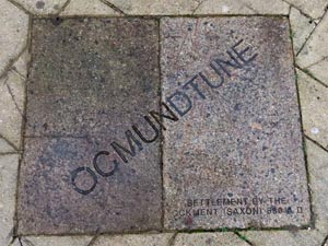
Stone Type: |
Marker
Stone |
|
|
|
|
|
|
|
Grid Reference: |
SX/5872/9524 |
|
|
|
|
|
|
|
Location: |
Set
into the groundwork of Market Square |
|
|
|
|
|
|
|
Inscription: |
OCMUNDTUNE
- Settlement by the Ockment (Saxon) 680AD |
|
|
|
|
|
|
|
|
|
|
|
|
|
|
|
|
|
|
|
|
|
|
|
|
|
|
|
|
|
|
|
|
|
|
|
|
|
|
|
|
|
|
|
|
|
|
|
|
|
|
|
|
|
|
Stone Type: |
Boundary
Stone |
|
|
|
|
|
|
|
|
|
Grid Reference: |
SX/5970/9462 |
|
|
|
|
|
|
|
|
|
Location: |
At
the side of the footpath through Ball Hill Woods |
|
|
|
|
|
|
|
|
|
Inscription: |
OBB
1935 (Okehampton Borough Bounds) |
|
|
|
|
|
|
|
|
|
|
|
|
|
|
|
|
|
|
|
|
|
|
|
|
|
|
|
|
|
|
|
|
|
|
|
|
|
|
|
|
|
|
|
|
|
|
|
|
|
|
|
|
|
|
|
|
|
|
|
|
|
|
|
|
|
|
|
|
|
|
|
|
|
|
|
|
|
|
|
|
|
|
|
|
|
|
|
|
|
|
|
|
|
|
|
|
|
|
|
|
|
|
|
|
|
|
Stone Type: |
Boundary
Stone |
|
|
|
|
|
|
|
|
Grid Reference: |
SX/5901/9403 |
|
|
|
|
|
|
|
|
Location: |
Against
the hedge on the southern verge of Camp Road |
|
|
|
|
|
|
|
|
Inscription: |
OBB
1935 (Okehampton Borough Bounds) |
|
|
|
|
|
|
|
|
|
|
|
|
|
|
|
|
|
|
|
|
|
|
|
|
|
|
|
|
|
|
|
|
|
|
|
|
|
|
|
|
|
|
|
|
|
|
|
|
|
|
|
|
|
|
|
|
|
|
|
|
|
|
|
|
|
|
|
|
|
|
|
|
|
|
|
|
|
|
|
|
|
|
|
|
|
|
|
|
|
|
|
|
Stone Type: |
Boundary
Stone |
|
|
|
|
|
|
|
|
|
Grid Reference: |
SX/5995/9517 |
|
|
|
|
|
|
|
|
|
Location: |
Against
the hedge on the north-east side of Fatherford Lane |
|
|
|
|
|
|
|
|
|
Inscription: |
OBB
1935 (Okehampton Borough Bounds) |
|
|
|
|
|
|
|
|
|
|
|
|
|
|
|
|
|
|
|
|
|
|
|
|
|
|
|
|
|
|
|
|
|
|
|
|
|
|
|
|
|
|
|
|
|
|
|
|
|
|
|
|
|
|
|
|
|
|
|
|
|
|
|
|
|
|
|
|
|
|
|
|
|
|
|
|
|
|
|
|
|
|
|
|
|
|
|
|
|
|
|
|
|
|
|
|
|
|
|
|
|
|
|
|
|
|
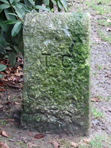
Stone Type: |
Boundary
Stone |
|
|
|
|
|
|
|
|
Grid Reference: |
SX/5901/9464 |
|
|
|
|
|
|
|
|
Location: |
Beside
the main path through Simmons Park |
|
|
|
|
|
|
|
|
Inscription: |
T
C (Town Council) |
|
|
|
|
|
|
|
|
Notes: |
The
stone marks the boundary between land owned by the Town Council and that
of the Okehampton United Charities. |
|
|
|
|
|
|
|
|
|
|
|
|
|
|
|
|
|
|
|
|
|
|
|
|
|
|
|
|
|
|
|
|
|
|
|
|
|
|
|
|
|
|
|
|
|
|
|
|
|
|
|
|
|
|
|
|
|
|
|
|
|
|
|
|
|
|
|
|
|
|
|
|
|
|
|
Stone Type: |
Boundary
Stone |
|
|
|
|
|
|
|
|
|
Grid Reference: |
SX/5900/9461 |
|
|
|
|
|
|
|
|
|
Location: |
Beside
a side path in Simmons Park |
|
|
|
|
|
|
|
|
|
Inscription: |
T
C (Town Council) |
|
|
|
|
|
|
|
|
| Notes: |
The
stone marks the boundary between land owned by the Town Council and that
of the Okehampton United Charities. |
|
|
|
|
|
|
|
|
|
|
|
|
|
|
|
|
|
|
|
|
|
|
|
|
|
|
|
|
|
|
|
|
|
|
|
|
|
|
|
|
|
|
|
|
|
|
|
|
|
|
|
|
|
|
|
|
|
|
|
|
|
|
|
|
|
|
|
|
|
|
|
|
|
|
|
|
|
|
|
|
|
|
|
|
|
|
|
|
|
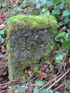
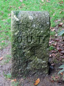
Stone Type: |
Boundary
Stone |
|
|
|
|
|
|
|
|
Grid Reference: |
SX/5901/9464 |
|
|
|
|
|
|
|
|
Location: |
Beside
the main path through Simmons Park |
|
|
|
|
|
|
|
|
Inscription: |
O
U T (Okehampton United Trust - Now Okehampton United Charities) |
|
|
|
|
|
|
|
|
Notes: |
This
stone is the reverse face of the one directly above. |
|
|
|
|
|
|
|
|
|
|
|
|
|
|
|
|
|
|
|
|
|
|
|
|
|
|
|
|
|
|
|
|
|
|
|
|
|
|
|
|
|
|
|
|
|
|
|
|
|
|
|
|
|
|
|
|
|
|
|
|
|
|
|
|
|
|
|
|
|
|
|
|
|
|
|
|
|
|
|
|
|
|
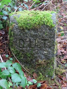
Stone Type: |
Boundary
Stone |
|
|
|
|
|
|
|
|
|
Grid Reference: |
SX/5900/9461 |
|
|
|
|
|
|
|
|
|
Location: |
Beside
a side path in Simmons Park |
|
|
|
|
|
|
|
|
|
Inscription: |
O
U T (Okehampton United Trust - Now Okehampton United Charities) |
|
|
|
|
|
|
|
|
| Notes: |
This
stone is the reverse face of the one directly above. |
|
|
|
|
|
|
|
|
|
|
|
|
|
|
|
|
|
|
|
|
|
|
|
|
|
|
|
|
|
|
|
|
|
|
|
|
|
|
|
|
|
|
|
|
|
|
|
|
|
|
|
|
|
|
|
|
|
|
|
|
|
|
|
|
|
|
|
|
|
|
|
|
|
|
|
|
|
|
|
|
|
|
|
|
|
|
|
|
|
|
|
|
|
|
|
|
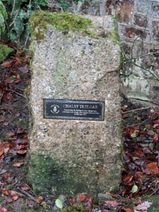
Stone Type: |
Marker
Stone |
|
|
|
|
|
|
|
|
Grid Reference: |
SX/5899/9463 |
|
|
|
|
|
|
|
|
Location: |
In
front of Chalet Treloar in Simmons Park |
|
|
|
|
|
|
|
|
Inscription: |
Chalet
Treloar / Named after Sir William Purdie Treloar Bart. |
|
|
|
|
|
|
|
|
|
|
|
|
|
|
|
|
|
|
|
|
|
|
|
|
|
|
|
|
|
|
|
|
|
|
|
|
|
|
|
|
|
|
|
|
|
|
|
|
|
|
|
|
|
|
|
|
|
|
|
|
|
|
|
|
|
|
|
|
|
|
|
|
|
|
|
|
|
|
|
|
|
|
|
|
|
|
|
|
|
|
|
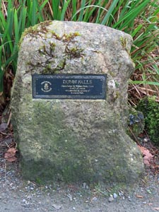
Stone Type: |
Marker
Stone |
|
|
|
|
|
|
|
|
|
Grid Reference: |
SX/5897/9465 |
|
|
|
|
|
|
|
|
|
Location: |
In
front of the water feature, beside Chalet Treloar, in Simmons Park. |
|
|
|
|
|
|
|
|
|
Inscription: |
Dunn
Falls - Named after Sir William Henry Dunn, Sheriff of London |
|
|
|
|
|
|
|
|
|
|
|
|
|
|
|
|
|
|
|
|
|
|
|
|
|
|
|
|
|
|
|
|
|
|
|
|
|
|
|
|
|
|
|
|
|
|
|
|
|
|
|
|
|
|
|
|
|
|
|
|
|
|
|
|
|
|
|
|
|
|
|
|
|
|
|
|
|
|
|
|
|
|
|
|
|
|
|
|
|
|
|
|
|
|
|
|
|
|
|
|
|
|
|
|
|
|
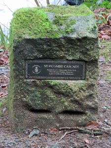
Stone Type: |
Marker
Stone |
|
|
|
|
|
|
|
|
Grid Reference: |
SX/5895/9467 |
|
|
|
|
|
|
|
|
Location: |
Between
the main path and River Okement in Simmons Park |
|
|
|
|
|
|
|
|
Inscription: |
Newcombe
Cascade - Named after J. J. Newcombe, Okehampton Town Clerk |
|
|
|
|
|
|
|
|
|
|
|
|
|
|
|
|
|
|
|
|
|
|
|
|
|
|
|
|
|
|
|
|
|
|
|
|
|
|
|
|
|
|
|
|
|
|
|
|
|
|
|
|
|
|
|
|
|
|
|
|
|
|
|
|
|
|
|
|
|
|
|
|
|
|
|
|
|
|
|
|
|
|
|
|
|
|
|
|
|
|
|
|
|
|
|
|
|
| |
|
|
|
|
|
|
|
|
|
|
|
|
|
|
|
|
|
|
|
|
|
|
|
|
|
|
|
|
|
|
|
|
|
|
|
|
|
|
|