| |
|
|
|
|
|
|
|
|
|
|
|
|
| |
|
|
|
|
|
|
|
|
|
|
|
|
|
|
|
|
|
|
|
|
District: |
West Devon |
|
|
|
|
|
|
|
|
|
|
|
 |
|
| |
|
|
|
|
|
|
|
|
|
|
|
|
|
|
|
|
|
|
Parish: |
Sampford Spiney |

|

|
 |
|
|
|
|
| |
|
|
|
|
|
|
|
|
|
|
|
|
|
|
|
|
|
|
|
| |
|
|
|
|
|
|
|
|
|
|
|
|
|
|
|
|
|
|
|
| |
|
|
|
|
|
|
|
|
|
|
|
|
|
|
|
|
|
|
|
| Page
Contents: |
|
| |
9 Boundary Stones |
| |
2 Crosses |
| |
3
Marker Stones |
| |
1
Milestone |
| |
|
| |
|
|
|
|
|
|
|
|
|
|
|
|
|
|
|
|
|
|
| |
|
|
|
|
|
|
|
|
|
|
|
|
|
| |
|
|
|
|
|
|
|
|
|
|
|
|
|
| |
|
|
|
|
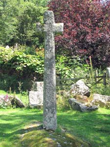
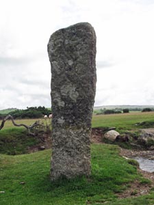
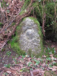
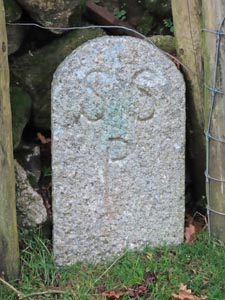
Stone Type: |
Village Cross |
| |
|
|
|
|
Grid Reference: |
SX/5337/7244 |
| |
|
|
|
|
Location: |
On the Sampford Spiney village green, beside the brook that runs across the
green. |
| |
|
|
|
|
|
|
| |
|
|
|
|
|
|
|
|
|
| |
|
|
|
|
|
|
|
|
|
|
|
|
|
|
|
|
|
|
|
|
|
|
|
|
|
|
|
|
|
|
|
|
|
|
|
|
|
|
|
|
|
|
|
|
|
|
|
|
|
| |
|
|
|
|
|
|
|
|
|
|
|
|
|
| |
|
|
|
|
|
|
|
|
|
|
|
|
|
|
|
|
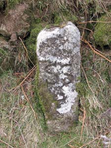
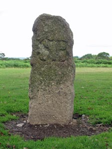
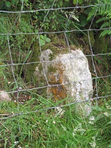
| Stone Type: |
Boundary Stone |
|
|
|
|
|
|
|
|
| Grid Reference: |
SX/5242/7291 |
|
|
|
|
|
|
|
|
| Location: |
At the junction of the minor road from Moortown, with the road running from
Warren's Cross to Sampford Spiney. |
|
|
|
|
|
|
|
|
| Inscription: |
S S P (Sampford Spiney Parish) |
|
|
|
|
|
|
|
|
| |
|
|
|
|
|
|
|
|
|
| |
|
|
|
|
|
|
|
|
|
|
|
|
|
|
|
|
| |
|
|
|
|
|
|
|
|
|
|
|
|
|
|
|
|
| |
|
|
|
|
|
|
|
|
|
|
|
|
|
|
| |
|
|
|
|
|
|
|
|
|
|
|
|
|
| |
|
|
|
|
|
|
|
|
|
|
|
|
|
|
|
|
| |
|
|
|
|
|
|
|
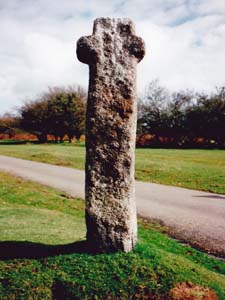
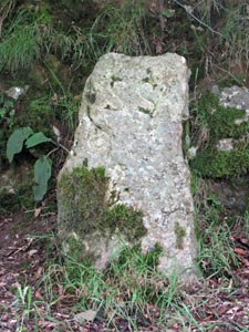
Stone Type: |
Huckworthy Common (Waymarker) Cross |
| |
|
|
|
|
|
|
|
Grid Reference: |
SX/530/711 |
| |
|
|
|
|
|
|
|
Location: |
At the road junction on the north west corner of Huckworthy Common. |
| |
|
|
|
|
|
|
|
Notes: |
Waymarker to the Church at Sampford Spiney. |
| |
|
|
|
|
|
|
|
|
|
| |
|
|
|
|
|
|
|
|
|
|
|
|
|
|
|
|
|
|
|
|
|
|
|
|
|
|
|
|
|
|
|
|
|
|
|
|
|
|
|
|
|
|
|
|
|
|
|
|
|
|
|
|
|
|
|
|
|
|
|
|
|
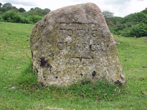
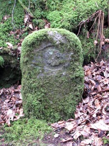
| Stone Type: |
Waymarker
Stone |
|
|
|
|
|
|
|
| Grid Reference: |
SX/5349/7285 |
|
|
|
|
|
|
|
| Location: |
On
the eastern verge of the 'T' Junction at Eastontown |
|
|
|
|
|
|
|
| Inscription: |
To
The Church (Sampford Spiney Church) |
|
|
|
|
|
|
|
|
|
|
|
|
|
|
|
|
|
|
|
|
|
|
|
|
|
|
|
|
|
|
|
|
|
|
|
|
|
|
|
|
|
|
|
|
|
|
|
|
|
|
|
|
|
|
|
|
|
|
|
|
|
|
|
|
|
|
|
|
Stone Type: |
Plymouth
& Tavistock Turnpike Trust Milestone |
|
|
|
|
|
|
|
|
Grid Reference: |
SX/5164/7237 |
|
|
|
|
|
|
|
|
Location: |
Beside
the Grimstone & Sortridge Leat on Plaster Down. |
|
|
|
|
|
|
|
|
Inscription: |
12
Miles To Plymo |
|
|
|
|
|
|
|
|
Notes: |
The
stone has been moved onto the moor from its original roadside position.
See also the note on Turnpike Trusts on the Home Page. |
|
|
|
|
|
|
|
|
|
|
|
|
|
|
|
|
|
|
|
|
|
|
|
|
|
|
|
|
|
|
|
|
|
|
|
|
|
|
|
|
|
|
|
|
|
|
|
|
|
|
|
|
|
|
|
|
|
|
|
|
|
|
|
|
|
|
|
|
|
|
|
|
|
|
|
|
|
|
|
|
|
| Stone Type: |
Boundary
Stone |
|
|
|
|
|
|
|
|
| Grid Reference: |
SX/5164/7113 |
|
|
|
|
|
|
|
|
| Location: |
Against
the road wall on Plaster Down. |
|
|
|
|
|
|
|
|
| Inscription: |
S
S P (Sampford Spiney Parish) |
|
|
|
|
|
|
|
|
|
|
|
|
|
|
|
|
|
|
|
|
|
|
|
|
|
|
|
|
|
|
|
|
|
|
|
|
|
|
|
|
|
|
|
|
|
|
|
|
|
|
|
|
|
|
|
|
|
|
|
|
|
|
|
|
|
|
|
|
|
|
|
|
|
|
|
|
|
|
|
|
|
|
|
|
|
|
|
|
|
|
|
|
|
|
|
|
|
|
|
|
|
|
|
|
|
|
Stone Type: |
Boundary
Stone |
|
|
|
|
|
|
|
|
Grid Reference: |
SX/5414/7207 |
|
|
|
|
|
|
|
|
Location: |
Up
the hill and just around the corner from Ward Bridge |
|
|
|
|
|
|
|
|
Inscription: |
C - (County Bridge Stone - see note on Home Page) |
|
|
|
|
|
|
|
|
|
|
|
|
|
|
|
|
|
|
|
|
|
|
|
|
|
|
|
|
|
|
|
|
|
|
|
|
|
|
|
|
|
|
|
|
|
|
|
|
|
|
|
|
|
|
|
|
|
|
|
|
|
|
|
|
|
|
|
|
|
|
|
|
|
|
|
|
|
|
|
|
|
|
|
|
|
|
|
|
|
|
|
|
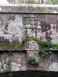
Stone Type: |
Bridge
Marker Stone |
|
|
|
|
|
|
|
|
|
Grid Reference: |
SX/5419/7201 |
|
|
|
|
|
|
|
|
|
Location: |
Just
above the main arch on the south face of Ward Bridge |
|
|
|
|
|
|
|
|
| Inscription: |
1891
(Date) |
|
|
|
|
|
|
|
|
|
Notes: |
There
is a further inscription above the date which I'm unable to decipher. |
|
|
|
|
|
|
|
|
|
|
|
|
|
|
|
|
|
|
|
|
|
|
|
|
|
|
|
|
|
|
|
|
|
|
|
|
|
|
|
|
|
|
|
|
|
|
|
|
|
|
|
|
|
|
|
|
|
|
|
|
|
|
|
|
|
|
|
|
|
|
|
|
|
|
|
|
|
|
|
|
|
|
|
|
|
|
|
|
|
|
|
|
|
|
|
|
Stone Type: |
Boundary
Stone |
|
|
|
|
|
|
|
|
Grid Reference: |
SX/5429/7201 |
|
|
|
|
|
|
|
|
Location: |
On
the south verge of the road, to the east of Ward Bridge |
|
|
|
|
|
|
|
|
Inscription: |
C - (County Bridge Stone - see note on Home Page) |
|
|
|
|
|
|
|
|
|
|
|
|
|
|
|
|
|
|
|
|
|
|
|
|
|
|
|
|
|
|
|
|
|
|
|
|
|
|
|
|
|
|
|
|
|
|
|
|
|
|
|
|
|
|
|
|
|
|
|
|
|
|
|
|
|
|
|
|
|
|
|
|
|
|
|
|
|
|
|
|
|
|
|
|
|
|
|
|
|
|
|
|
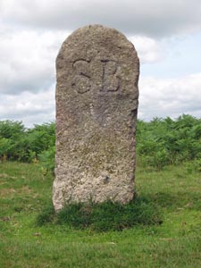
Stone Type: |
Boundary
Stone |
|
|
|
|
|
|
|
|
|
Grid Reference: |
SX/5171/7180 |
|
|
|
|
|
|
|
|
|
Location: |
On
the north east verge of the road across Plaster Down |
|
|
|
|
|
|
|
|
| Inscription: |
S
B (Sampford Bounds) |
|
|
|
|
|
|
|
|
|
Notes: |
Shares
its boundary with Whitchurch |
|
|
|
|
|
|
|
|
|
|
|
|
|
|
|
|
|
|
|
|
|
|
|
|
|
|
|
|
|
|
|
|
|
|
|
|
|
|
|
|
|
|
|
|
|
|
|
|
|
|
|
|
|
|
|
|
|
|
|
|
|
|
|
|
|
|
|
|
|
|
|
|
|
|
|
|
|
|
|
|
|
|
|
|
|
|
|
|
|
|
|
|
|
|
|
|
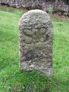
Stone Type: |
Boundary
Stone |
|
|
|
|
|
|
|
|
Grid Reference: |
SX/5165/7169 |
|
|
|
|
|
|
|
|
Location: |
On
the eastern verge of the unclassified road to Horrabridge. |
|
|
|
|
|
|
|
|
Inscription: |
S
B (Sampford Bounds) |
|
|
|
|
|
|
|
|
Notes: |
Shares
its boundary with Whitchurch |
|
|
|
|
|
|
|
|
|
|
|
|
|
|
|
|
|
|
|
|
|
|
|
|
|
|
|
|
|
|
|
|
|
|
|
|
|
|
|
|
|
|
|
|
|
|
|
|
|
|
|
|
|
|
|
|
|
|
|
|
|
|
|
|
|
|
|
|
|
|
|
|
|
|
|
|
|
|
|
|
|
|
Stone Type: |
Boundary
Stone |
|
|
|
|
|
|
|
|
|
Grid Reference: |
SX/5164/7142 |
|
|
|
|
|
|
|
|
|
Location: |
On
the western verge of the unclassified road to Horrabridge. |
|
|
|
|
|
|
|
|
| Inscription: |
S
B (Sampford Bounds) |
|
|
|
|
|
|
|
|
|
Notes: |
Shares
its boundary with Whitchurch |
|
|
|
|
|
|
|
|
|
|
|
|
|
|
|
|
|
|
|
|
|
|
|
|
|
|
|
|
|
|
|
|
|
|
|
|
|
|
|
|
|
|
|
|
|
|
|
|
|
|
|
|
|
|
|
|
|
|
|
|
|
|
|
|
|
|
|
|
|
|
|
|
|
|
|
|
|
|
|
|
|
|
|
|
|
|
|
|
|
|
|
|
|
|
|
|
Stone Type: |
Boundary
Stone |
|
|
|
|
|
|
|
|
Grid Reference: |
SX/5178/7132 |
|
|
|
|
|
|
|
|
Location: |
Tucked
under the hedge, to the east of the unclassified road to Horrabridge. |
|
|
|
|
|
|
|
|
Inscription: |
S
B (Sampford Bounds) |
|
|
|
|
|
|
|
|
Notes: |
Shares
its boundary with Whitchurch |
|
|
|
|
|
|
|
|
|
|
|
|
|
|
|
|
|
|
|
|
|
|
|
|
|
|
|
|
|
|
|
|
|
|
|
|
|
|
|
|
|
|
|
|
|
|
|
|
|
|
|
|
|
|
|
|
|
|
|
|
|
|
|
|
|
|
|
|
|
|
|
|
|
|
|
|
|
|
|
|
|
|
Stone Type: |
Boundary
Stone |
|
|
|
|
|
|
|
|
|
Grid Reference: |
SX/53012/72755 |
|
|
|
|
|
|
|
|
|
Location: |
At
a minor road junction, 500 yards north-west of Sampford Spiney village |
|
|
|
|
|
|
|
|
| Inscription: |
S
S P (Sampford Spiney Parish) |
|
|
|
|
|
|
|
|
|
|
|
|
|
|
|
|
|
|
|
|
|
|
|
|
|
|
|
|
|
|
|
|
|
|
|
|
|
|
|
|
|
|
|
|
|
|
|
|
|
|
|
|
|
|
|
|
|
|
|
|
|
|
|
|
|
|
|
|
|
|
|
|
|
|
|
|
|
|
|
|
|
|
|
|
|
|
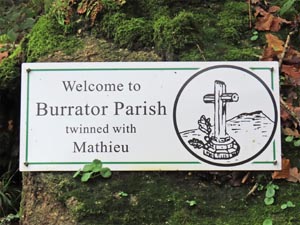
Stone Type: |
Marker
Stone |
|
|
|
|
|
|
|
Grid Reference: |
SX/54277/72024 |
|
|
|
|
|
|
|
Location: |
High
up on the bank, 70 yards east of Ward Bridge |
|
|
|
|
|
|
|
Inscription: |
Welcome
to / Burrator Parish / twinned with / Mathieu |
|
|
|
|
|
|
|
|
|
|
|
|
|
|
|
|
|
|
|
|
|
|
|
|
|
|
|
|
|
|
|
|
|
|
|
|
|
|
|
|
|
|
|
|
|
|
|
|
|
|
|
|
|
|
|
|
|
|
|
|
|
| |
|
|
|
|
|
|
|
|
|
|
|
|
|
|
|
|
|
|
|
|
|
|
|
|
|
|
|
|
|
|
|
|
|
|
|
|
|
|
|