| |
|
|
|
|
|
|
|
|
|
|
|
|
| |
|
|
|
|
|
|
|
|
|
|
|
|
|
|
|
|
|
|
|
|
District: |
West Devon |
|
|
|
|
|
|
|
|
|
|
|
 |
|
| |
|
|
|
|
|
|
|
|
|
|
|
|
|
|
|
|
|
|
Parish: |
Sourton |

|

|
 |
|
|
|
|
| |
|
|
|
|
|
|
|
|
|
|
|
|
|
|
|
|
|
|
|
| |
|
|
|
|
|
|
|
|
|
|
|
|
|
|
|
|
|
|
|
| |
|
|
|
|
|
|
|
|
|
|
|
|
|
|
|
|
|
|
|
| Page
Contents: |
|
| |
4 Boundary Stones |
| |
2 Crosses |
| |
1 Marker Stone |
| |
5 Milestones |
| |
|
| |
|
|
|
|
|
|
|
|
|
|
|
|
|
|
|
|
|
|
| |
|
|
|
|
|
|
|
|
|
|
|
|
|
| |
|
|
|
|
|
|
|
|
|
|
|
|
|
| |
|
|
|
|
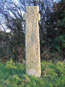
Stone Type: |
Village Cross |
| |
|
|
|
|
Grid Reference: |
SX/5347/9032 |
| |
|
|
|
|
Location: |
On the Sourton Village Green, opposite the Highwayman Inn. |
| |
|
|
|
|
Notes: |
This is a Saxon Cross, dating from around the 10th Century. |
| |
|
|
|
|
|
|
|
|
|
| |
|
|
|
|
|
|
|
|
|
|
|
|
|
|
|
|
| |
|
|
|
|
|
|
|
|
|
|
|
|
|
|
|
|
| |
|
|
|
|
|
|
|
|
|
|
|
|
|
|
|
|
|
|
|
|
|
|
|
|
|
|
|
|
|
|
|
|
| |
|
|
|
|
|
|
|
|
|
|
|
|
|
|
|
|
| |
|
|
|
|
|
|
|
|
|
|
|
|
|
|
|
|
|
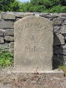
Stone Type: |
Milestone |
|
|
|
|
|
|
|
|
|
Grid Reference: |
SX/5333/9006 |
|
|
|
|
|
|
|
|
|
Location: |
On the western side of the A386, on the southern edge of Sourton Village. |
|
|
|
|
|
|
|
|
|
Inscription: |
Okehampton 5 Miles |
|
|
|
|
|
|
|
|
| |
|
|
|
|
|
|
|
|
|
| |
|
|
|
|
|
|
|
|
|
|
|
|
|
|
|
|
| |
|
|
|
|
|
|
|
|
|
|
|
|
|
|
|
|
| |
|
|
|
|
|
|
|
|
|
|
|
|
|
|
| |
|
|
|
|
|
|
|
|
|
|
|
|
|
| |
|
|
|
|
|
|
|
|
|
|
|
|
|
|
|
|
| |
|
|
|
|
|
|
|
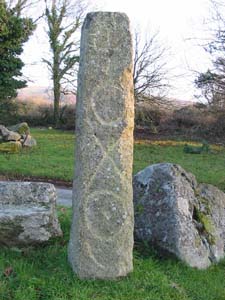
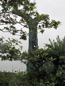
Stone Type: |
Wayside Cross |
| |
|
|
|
|
|
|
|
Grid Reference: |
SX/5455/9155 |
| |
|
|
|
|
|
|
|
Location: |
On the east side of the minor road leading from the A386 to the Prewley Moor
Arms. |
| |
|
|
|
|
|
|
|
Inscription: |
H (Hatherleigh) O (Okehampton) L (Launceston) T (Tavistock) |
| |
|
|
|
|
|
|
|
Notes: |
An inscription is shown on each of the 4 faces of the cross. The cross
also shows some Romano-Christian engraving. |
| |
|
|
|
|
|
|
|
|
|
|
|
|
|
|
|
|
| |
|
|
|
|
|
|
|
|
|
|
|
|
|
|
|
|
|
|
|
|
|
|
|
|
|
|
|
|
|
|
|
|
| |
|
|
|
|
|
|
|
|
|
|
|
|
|
| |
|
|
|
|
|
|
|
|
|
|
|
|
|
|
|
|
|
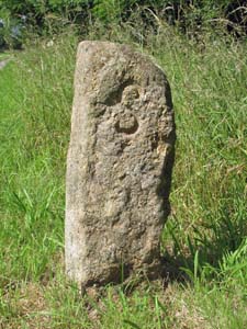
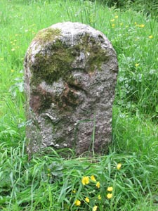
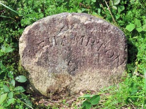
Stone Type: |
Boundary Stone |
|
|
|
|
|
|
|
|
|
Grid Reference: |
SX/5181/8990 |
|
|
|
|
|
|
|
|
|
Location: |
On the grass verge at Pool Cross, to the north east of Bridestowe Village. |
|
|
|
|
|
|
|
|
|
Inscription: |
S (Sourton) |
|
|
|
|
|
|
|
|
| Notes: |
The
stone shares its boundary with Bridestowe |
|
|
|
|
|
|
|
|
|
|
|
|
|
|
|
|
|
|
|
|
|
|
|
|
|
|
|
|
|
|
|
|
|
|
|
|
|
|
|
|
|
|
|
|
|
|
|
|
|
|
|
|
|
|
|
|
|
|
|
|
|
|
|
|
|
|
|
|
|
|
|
|
|
|
|
|
|
|
|
|
|
|
|
|
|
|
|
|
|
|
|
|
|
|
|
|
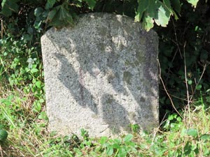
Stone Type: |
Boundary
Stone |
|
|
|
|
|
|
|
|
Grid Reference: |
SX/5514/9195 |
|
|
|
|
|
|
|
|
Location: |
On
the southern grass verge of the Granite Way (Cycle Path) |
|
|
|
|
|
|
|
|
Inscription: |
S
(Sourton) |
|
|
|
|
|
|
|
|
Notes: |
The
stone shares its boundary with Okehampton Hamlets |
|
|
|
|
|
|
|
|
|
|
|
|
|
|
|
|
|
|
|
|
|
|
|
|
|
|
|
|
|
|
|
|
|
|
|
|
|
|
|
|
|
|
|
|
|
|
|
|
|
|
|
|
|
|
|
|
|
|
|
|
|
|
|
|
|
|
|
|
|
|
|
|
|
|
|
|
|
|
|
|
|
|
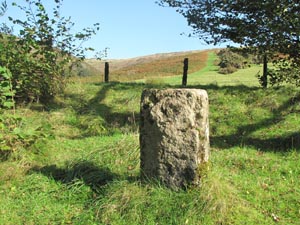
Stone Type: |
Boundary Stone |
|
|
|
|
|
|
|
|
|
Grid Reference: |
SX/5256/8751 |
|
|
|
|
|
|
|
|
|
Location: |
On
the south eastern grass verge of the Granite Way (Cycle Path) |
|
|
|
|
|
|
|
|
|
Inscription: |
S (Sourton) |
|
|
|
|
|
|
|
|
| Notes: |
The
stone shares its boundary with Bridestowe |
|
|
|
|
|
|
|
|
|
|
|
|
|
|
|
|
|
|
|
|
|
|
|
|
|
|
|
|
|
|
|
|
|
|
|
|
|
|
|
|
|
|
|
|
|
|
|
|
|
|
|
|
|
|
|
|
|
|
|
|
|
|
|
|
|
|
|
|
|
|
|
|
|
|
|
|
|
|
|
|
|
|
|
|
|
|
|
|
|
|
|
|
|
|
|
|
Stone Type: |
Milestone |
|
|
|
|
|
|
|
|
Grid Reference: |
SX/5363/9026 |
|
|
|
|
|
|
|
|
Location: |
On
the Granite Way at Sourton. |
|
|
|
|
|
|
|
|
Inscription: |
2¼M
Meldon Viaduct / 5M Okehampton / Lake Viaduct 1M / Lydford 4M. |
|
|
|
|
|
|
|
|
Notes: |
The
milestone was sponsored by the Royal Bank of Scotland. |
|
|
|
|
|
|
|
|
|
|
|
|
|
|
|
|
|
|
|
|
|
|
|
|
|
|
|
|
|
|
|
|
|
|
|
|
|
|
|
|
|
|
|
|
|
|
|
|
|
|
|
|
|
|
|
|
|
|
|
|
|
|
|
|
|
|
|
|
|
|
|
|
|
|
|
|
|
|
|
|
|
|
Stone Type: |
Milestone |
|
|
|
|
|
|
|
|
|
Grid Reference: |
SX/5275/8788 |
|
|
|
|
|
|
|
|
|
Location: |
High
on the bank beside the Granite Way foot/cyclepath. |
|
|
|
|
|
|
|
|
|
Inscription: |
6M
Okehampton / Lydford 2¼M |
|
|
|
|
|
|
|
|
| Notes: |
The
milestone was sponsored by the Royal Bank of Scotland. |
|
|
|
|
|
|
|
|
|
|
|
|
|
|
|
|
|
|
|
|
|
|
|
|
|
|
|
|
|
|
|
|
|
|
|
|
|
|
|
|
|
|
|
|
|
|
|
|
|
|
|
|
|
|
|
|
|
|
|
|
|
|
|
|
|
|
|
|
|
|
|
|
|
|
|
|
Stone Type: |
Boundary
Stone |
|
|
|
|
|
|
|
Grid Reference: |
SX/5336/8897 |
|
|
|
|
|
|
|
Location: |
On
the grass verge beside the Granite Way Cycle/Foot path. |
|
|
|
|
|
|
|
Inscription: |
There
doesn't appear to be an inscription on this stone. |
|
|
|
|
|
|
|
|
|
|
|
|
|
|
|
|
|
|
|
|
|
|
|
|
|
|
|
|
|
|
|
|
|
|
|
| Stone Type: |
Milestone |
|
|
|
|
|
|
|
| Grid Reference: |
SX/54145/91538 |
|
|
|
|
|
|
|
| Location: |
Near
the junction where the road from Bridestowe meets A386. |
|
|
|
|
|
|
|
| Inscription: |
Okehampton
4 Miles |
|
|
|
|
|
|
|
|
|
|
|
|
|
|
|
|
|
|
|
|
|
|
|
|
|
|
|
|
|
|
|
|
|
|
|
|
|
|
|
|
|
|
|
|
|
|
|
|
Stone Type: |
Milestone |
|
|
|
|
|
|
|
Grid Reference: |
SX/52740/90708 |
|
|
|
|
|
|
|
Location: |
On
the north western verge of the C822, Bridestowe to Sourton Down road. |
|
|
|
|
|
|
|
Inscription: |
Okehampton
5 Miles |
|
|
|
|
|
|
|
|
|
|
|
|
|
|
|
|
|
|
|
|
|
|
|
|
|
|
|
|
|
|
|
|
|
|
|
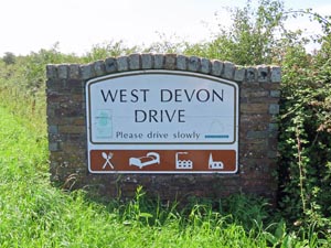
| Stone Type: |
Marker
Stone |
|
|
|
|
|
|
|
| Grid Reference: |
SX/53915/91462 |
|
|
|
|
|
|
|
| Location: |
On
the northern verge of the C822, Bridestowe to Sourton Down road. |
|
|
|
|
|
|
|
| Inscription: |
West
Devon Drive |
|
|
|
|
|
|
|
| Notes: |
The
monument marks the eastern end of the West Devon Drive, with Launceston at
the western end. |
|
|
|
|
|
|
|
|
|
|
|
|
|
|
|
|
|
|
|
|
|
|
|
|
|
|
|
|
|
|
|
|
|
|
|
|
|
|
|
|
|
|
|
|
|
|
|
|
|
|
|
|
|
|
|
|
|
|
|
| |
|
|
|
|
|
|
|
|
|
|
|
|
|
|
|
|
|
|
|
|
|
|
|
|
|
|
|
|
|
|
|
|
|
|
|
|
|
|
|