|
Devon Marker Stones |

|
|||||||||||||||||||||
 |
 |
 |
 |
 |
 |
 |
 |
 |
 |
 |
|
||||||||||||||||||||||||||||||||||||||||||
| District: | West Devon |
|
||||||||||||||||||||||||||||||||||||||||
| Parish: | Sticklepath | |||||||||||||||||||||||||||||||||||||||||
|
|
|||||||||||||||||||||||||||||||||||||||||
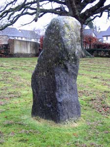
| Stone Type: | Village Green Marker Stone | |||||||||||||||||||||||||||||||||||||||||
| Grid Reference: | SX/642/941 | |||||||||||||||||||||||||||||||||||||||||
| Location: | On the village green in the centre of Sticklepath Village. | |||||||||||||||||||||||||||||||||||||||||
|
||||||||||||||||||||||||||||||||||||||||||
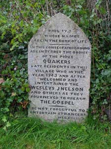
| Stone Type: | Quaker Churchyard Marker Stone | |||||||||||||||||||||||||||||||||||||||||
| Grid Reference: | SX/641/940 | |||||||||||||||||||||||||||||||||||||||||
| Location: | At the eastern end of the Quaker Churchyard, which is located to the rear of the Finch Foundry | |||||||||||||||||||||||||||||||||||||||||
| Notes: | Commemorates the burial of Quakers in this Churchyard from 1743 onwards. | |||||||||||||||||||||||||||||||||||||||||
|
||||||||||||||||||||||||||||||||||||||||||
| Stone Type: | Sticklepath Ladywell Cross | |||||||||||||||||||||||||||||||||||||||||
| Grid Reference: | SX/639/941 | |||||||||||||||||||||||||||||||||||||||||
| Location: | High up the bank at the junction of the road with the lane leading to Skaigh, at the western end of Sticklepath Village. | |||||||||||||||||||||||||||||||||||||||||
| Notes: | This is thought to be a Saxon Cross. | |||||||||||||||||||||||||||||||||||||||||
|
||||||||||||||||||||||||||||||||||||||||||
| Stone Type: | Sticklepath Bude Lane Cross | |||||||||||||||||||||||||||||||||||||||||
| Grid Reference: | SX/631/948 | |||||||||||||||||||||||||||||||||||||||||
| Location: | On the Sticklepath to Okehampton road at the junction with the lane leading to Bude Farm. | |||||||||||||||||||||||||||||||||||||||||
| Notes: | This is thought to be a Saxon Cross. | |||||||||||||||||||||||||||||||||||||||||
|
||||||||||||||||||||||||||||||||||||||||||
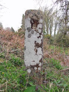
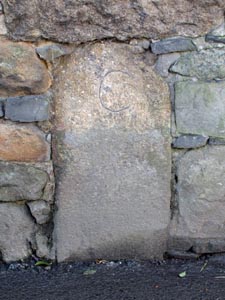
| Stone Type: | Boundary Stone | |||||||||||||||||||||||||||||||||||||||||
| Grid Reference: | SX/6427/9408 | |||||||||||||||||||||||||||||||||||||||||
| Location: | Built into the wall on the south side of the road, 75 yards to the west of the bridge over the River Taw. | |||||||||||||||||||||||||||||||||||||||||
| Inscription: | C (County) | |||||||||||||||||||||||||||||||||||||||||
| Notes: | See the Home Page for a note on County Bridge Stones | |||||||||||||||||||||||||||||||||||||||||
|
||||||||||||||||||||||||||||||||||||||||||
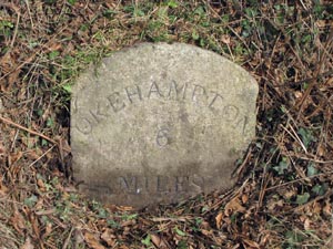
| Stone Type: | Milestone | |||||||||||||||||||||||||||||||||||||||||
| Grid Reference: | SX/6708/9291 | |||||||||||||||||||||||||||||||||||||||||
| Location: | On the north side of the road, 300 yards east of Fire Stone Cross. | |||||||||||||||||||||||||||||||||||||||||
| Inscription: | Okehampton 6 Miles | |||||||||||||||||||||||||||||||||||||||||
|
||||||||||||||||||||||||||||||||||||||||||
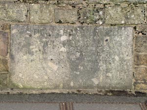
| Stone Type: | Bridge Marker Stone | |||||||||||||||||||||||||||||||||||||||||
| Grid Reference: | SX/6434/9404 | |||||||||||||||||||||||||||||||||||||||||
| Location: | Built into the northern parapet of the bridge over the River Taw. | |||||||||||||||||||||||||||||||||||||||||
| Inscription: | Sticklepath Bridge / Widened 1928 / At the Joint Expense of / Devon County Council and Ministry of Transport. | |||||||||||||||||||||||||||||||||||||||||
| Notes: | The inscription is almost worn away and difficult to decipher. | |||||||||||||||||||||||||||||||||||||||||
|
||||||||||||||||||||||||||||||||||||||||||
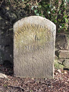
| Stone Type: | Milestone | |||||||||||||||||||||||||||||||||||||||||
| Grid Reference: | SX/6449/9376 | |||||||||||||||||||||||||||||||||||||||||
| Location: | On the east side of the road, at the entrance to Trafalgar House. | |||||||||||||||||||||||||||||||||||||||||
| Inscription: | Okehampton 4 Miles. | |||||||||||||||||||||||||||||||||||||||||
|
||||||||||||||||||||||||||||||||||||||||||
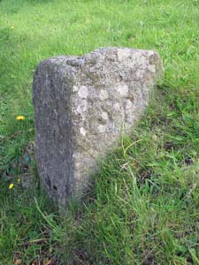
| Stone Type: | Boundary Stone | |||||||||||||||||||||||||||||||||||||||||
| Grid Reference: | SX/638/940 | |||||||||||||||||||||||||||||||||||||||||
| Location: | Beside the River Taw footpath at Sticklepath. | |||||||||||||||||||||||||||||||||||||||||
| Inscription: | S / BP / 2000 AD / ST (Sticklepath / Belstone Parish / Millennium / South Tawton). | |||||||||||||||||||||||||||||||||||||||||
| Notes: | This stone was erected as a millennium boundary stone. | |||||||||||||||||||||||||||||||||||||||||
|
||||||||||||||||||||||||||||||||||||||||||
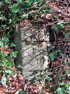
| Stone Type: | Boundary Stone | |||||||||||||||||||||||||||||||||||||||||
| Grid Reference: | SX/6447/9392 | |||||||||||||||||||||||||||||||||||||||||
| Location: | Set back in the hedge on the east side of the road, 10 yards up the hill from the last house. | |||||||||||||||||||||||||||||||||||||||||
| Inscription: | S T / S (South Tawton / Sticklepath) | |||||||||||||||||||||||||||||||||||||||||
|
||||||||||||||||||||||||||||||||||||||||||
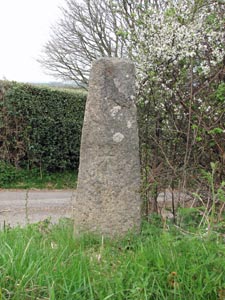
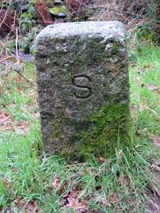
| Stone Type: | Boundary Stone | |||||||||||||||||||||||||||||||||||||||||
| Grid Reference: | SX/6232/9490 | |||||||||||||||||||||||||||||||||||||||||
| Location: | On the grass verge at the Tongue End road junction 1½ Kilometres to the north of Belstone Village centre. | |||||||||||||||||||||||||||||||||||||||||
| Inscription: | S P (Sticklepath Parish) | |||||||||||||||||||||||||||||||||||||||||
| Notes: | The stone marks the boundary between Belstone and Sticklepath (Sticklepath became a Parish in 1987). It is thought that this stone could once have been a portion of a cross shaft. | |||||||||||||||||||||||||||||||||||||||||