| |
|
|
|
|
|
|
|
|
|
|
|
|
| |
|
|
|
|
|
|
|
|
|
|
|
|
|
|
|
|
|
|
|
|
District: |
West Devon |
|
|
|
|
|
|
|
|
|
|
|
 |
|
| |
|
|
|
|
|
|
|
|
|
|
|
|
|
|
|
|
|
|
Parish: |
Walkhampton |
 |
 |
 |
|
|
|
|
| |
|
|
|
|
|
|
|
|
|
|
|
|
|
|
|
|
|
|
|
| |
|
|
|
|
|
|
|
|
|
|
|
|
|
|
|
|
|
|
|
| |
|
|
|
|
|
|
|
|
|
|
|
|
|
|
|
|
|
|
|
| Page
Contents: |
|
| |
7 Boundary Stones |
| |
4 Crosses |
| |
1
Guide Stone |
| |
1
Marker Stone |
| |
5
Milestones |
| |
|
|
|
|
|
|
|
|
|
|
|
|
|
|
|
|
|
|
| |
|
|
|
|
|
|
|
|
|
|
|
|
|
| |
|
|
|
|
|
|
|
|
|
|
|
|
|
| |
|
|
|
|
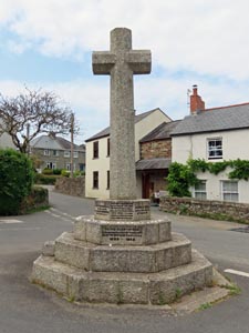
Stone Type: |
Walkhampton
Village Cross |
| |
|
|
|
|
Grid Reference: |
SX/53319/69673 |
| |
|
|
|
|
Location: |
In the crossroads in the centre of Walkhampton village. |
| |
|
|
|
|
Notes: |
The cross serves as the village war memorial. |
| |
|
|
|
|
|
|
|
|
|
| |
|
|
|
|
|
|
|
|
|
|
|
|
|
|
|
|
| |
|
|
|
|
|
|
|
|
|
|
|
|
|
|
|
|
| |
|
|
|
|
|
|
|
|
|
|
|
|
|
|
|
|
|
|
|
|
|
|
|
|
|
|
|
|
|
|
|
|
| |
|
|
|
|
|
|
|
|
|
|
|
|
|
|
|
|
| |
|
|
|
|
|
|
|
|
|
|
|
|
|
|
|
|
|
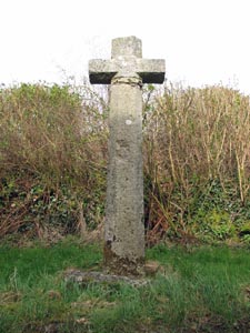
Stone Type: |
Walkhampton
Church Cross |
|
|
|
|
|
|
|
|
|
Grid Reference: |
SX/5372/7018 |
|
|
|
|
|
|
|
|
|
Location: |
Beside the path to Walkhampton Church, about ½ mile north east of the
village. |
|
|
|
|
|
|
|
|
|
Notes: |
This was once probably a waymarker cross that has been rescued and set up in
its current position for safe keeping. |
|
|
|
|
|
|
|
|
| |
|
|
|
|
|
|
|
|
|
| |
|
|
|
|
|
|
|
|
|
|
|
|
|
|
|
|
| |
|
|
|
|
|
|
|
|
|
|
|
|
|
|
|
|
| |
|
|
|
|
|
|
|
|
|
|
|
|
|
|
| |
|
|
|
|
|
|
|
|
|
|
|
|
|
| |
|
|
|
|
|
|
|
|
|
|
|
|
|
|
|
|
| |
|
|
|
|
|
|
|
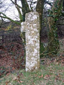
Stone Type: |
Yennadon (Waymarker) Cross |
| |
|
|
|
|
|
|
|
Grid Reference: |
SX/5453/6944 |
| |
|
|
|
|
|
|
|
Location: |
In the eastern corner of the junction between the B3212 and the minor road
from Walkhampton Church to Burrator Reservoir. |
| |
|
|
|
|
|
|
|
Notes: |
It is thought this cross originally marked the way to nearby Buckland Abbey. |
| |
|
|
|
|
|
|
|
|
|
| |
|
|
|
|
|
|
|
|
|
|
|
|
|
|
|
|
| |
|
|
|
|
|
|
|
|
|
|
|
|
|
|
|
|
|
|
|
|
|
|
|
|
|
|
|
|
|
|
|
|
| |
|
|
|
|
|
|
|
|
|
|
|
|
|
| |
|
|
|
|
|
|
|
|
|
|
|
|
|
|
|
|
|
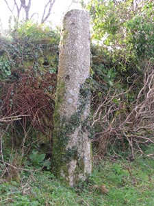
Stone Type: |
Welltown (Waymarker) Cross Shaft |
|
|
|
|
|
|
|
|
|
Grid Reference: |
SX/5407/7007 |
|
|
|
|
|
|
|
|
|
Location: |
On the minor road from Yennadon Cross to Walkhampton Church, close to the
entrance to the farm at Welltown. |
|
|
|
|
|
|
|
|
|
Inscription: |
This was once a waymarker for the route between the Abbeys of Buckfast and
Buckland. |
|
|
|
|
|
|
|
|
| |
|
|
|
|
|
|
|
|
|
| |
|
|
|
|
|
|
|
|
|
|
|
|
|
|
|
|
| |
|
|
|
|
|
|
|
|
|
|
|
|
|
|
|
|
| |
|
|
|
|
|
|
|
|
|
|
|
|
|
| |
|
|
|
|
|
|
|
|
|
|
|
|
|
|
|
|
|
|
|
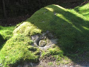
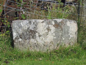
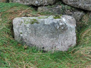
Stone Type: |
Boundary
Stone |
|
|
|
|
|
|
|
Grid Reference: |
SX/5669/6936 |
|
|
|
|
|
|
|
Location: |
On
the south verge of the minor road, west of Norsworthy Bridge. |
|
|
|
|
|
|
|
Inscription: |
C
- (County Bridge Stone - see note on Home Page) |
|
|
|
|
|
|
|
Notes: |
A
natural rock has been chosen to mark this boundary, rather than the normal
shaped stone. |
|
|
|
|
|
|
|
|
|
|
|
|
|
|
|
|
|
|
|
|
|
|
|
|
|
|
|
|
|
|
|
|
|
|
|
|
|
|
|
|
|
|
|
|
|
|
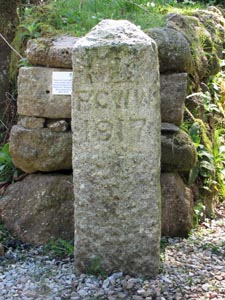
Stone Type: |
Boundary
Stone |
|
|
|
|
|
|
|
|
|
Grid Reference: |
SX/5581/7078 |
|
|
|
|
|
|
|
|
|
Location: |
On
the northern verge of the B3212, below Sharpitor. |
|
|
|
|
|
|
|
|
|
Inscription: |
PCWW
1917 (Plymouth Corporation Water Works). |
|
|
|
|
|
|
|
|
| Notes: |
This
marks the boundary of the water catchment area for the Burrator Reservoir. |
|
|
|
|
|
|
|
|
|
|
|
|
|
|
|
|
|
|
|
|
|
|
|
|
|
|
|
|
|
|
|
|
|
|
|
|
|
|
|
|
|
|
|
|
|
|
|
|
|
|
|
|
|
|
|
|
|
|
|
|
|
|
|
|
|
|
|
|
|
|
|
|
|
|
|
|
|
|
|
|
|
|
|
|
|
|
|
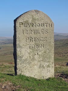
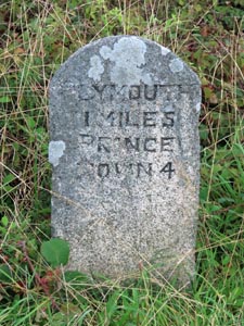
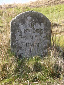
Stone Type: |
Milestone |
|
|
|
|
|
|
|
|
Grid Reference: |
SX/5581/7078 |
|
|
|
|
|
|
|
|
Location: |
On
the northern verge of the B3212, below Sharpitor. |
|
|
|
|
|
|
|
|
Inscription: |
Plymouth
12 Miles / Princetown 3 |
|
|
|
|
|
|
|
|
|
|
|
|
|
|
|
|
|
|
|
|
|
|
|
|
|
|
|
|
|
|
|
|
|
|
|
|
|
|
|
|
|
|
|
|
|
|
|
|
|
|
|
|
|
|
|
|
|
|
|
|
|
|
|
|
|
|
|
|
|
|
|
|
|
|
|
|
|
|
|
|
|
|
|
|
|
|
|
|
|
|
|
|
Stone Type: |
Boundary
Stone |
|
|
|
|
|
|
|
|
|
Grid Reference: |
SX/5582/7077 |
|
|
|
|
|
|
|
|
|
Location: |
On
the southern verge of the B3212, below Sharpitor. |
|
|
|
|
|
|
|
|
|
Inscription: |
PCWW
1917 (Plymouth Corporation Water Works). |
|
|
|
|
|
|
|
|
|
Notes: |
This
marks the boundary of the water catchment area for the Burrator Reservoir. |
|
|
|
|
|
|
|
|
|
|
|
|
|
|
|
|
|
|
|
|
|
|
|
|
|
|
|
|
|
|
|
|
|
|
|
|
|
|
|
|
|
|
|
|
|
|
|
|
|
|
|
|
|
|
|
|
|
|
|
|
|
|
|
|
|
|
|
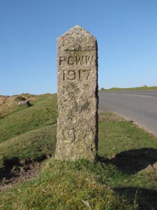
Stone Type: |
Boundary
Stone |
|
|
|
|
|
|
|
Grid Reference: |
SX/5501/7511 |
|
|
|
|
|
|
|
Location: |
Against
the wall/fence on the slip road running down from the Dartmoor Inn at
Merrivale. |
|
|
|
|
|
|
|
Inscription: |
Whitchurch
/ Walkhampton |
|
|
|
|
|
|
|
|
|
|
|
|
|
|
|
|
|
|
|
|
|
|
|
|
|
|
|
|
|
|
|
|
|
|
|
|
|
|
|
|
|
|
|
|
|
|
|
|
|
|
|
|
|
|
|
Stone Type: |
Boundary
Stone |
|
|
|
|
|
|
|
|
|
Grid Reference: |
SX/5519/6852 |
|
|
|
|
|
|
|
|
|
Location: |
In
the Car Park of the Dartmoor Discovery Centre. |
|
|
|
|
|
|
|
|
|
Inscription: |
PCWW
1917 (Plymouth Corporation Water Works). |
|
|
|
|
|
|
|
|
|
Notes: |
The
stone originally marked the boundary of the water catchment area for the Burrator
Reservoir, but has since been moved. |
|
|
|
|
|
|
|
|
|
|
|
|
|
|
|
|
|
|
|
|
|
|
|
|
|
|
|
|
|
|
|
|
|
|
|
|
|
|
|
|
|
|
|
|
|
|
|
|
|
|
|
|
|
|
|
|
|
|
|
|
|
|
|
|
|
|
|
|
|
|
|
|
|
|
|
|
|
|
|
|
|
|
|
|
|
|
|
|
|
|
|
|
|
|
|
|
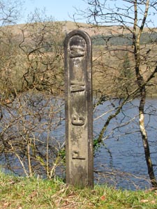
Stone Type: |
Boundary
Marker |
|
|
|
|
|
|
|
|
Grid Reference: |
SX/5638/6886 |
|
|
|
|
|
|
|
|
Location: |
Between
the road and the banks of the reservoir. |
|
|
|
|
|
|
|
|
Inscription: |
PCWW
(Plymouth Corporation Water Works). |
|
|
|
|
|
|
|
|
Notes: |
To
mark the reservoir boundary. |
|
|
|
|
|
|
|
|
|
|
|
|
|
|
|
|
|
|
|
|
|
|
|
|
|
|
|
|
|
|
|
|
|
|
|
|
|
|
|
|
|
|
|
|
|
|
|
|
|
|
|
|
|
|
|
|
|
|
|
|
|
|
|
|
|
|
|
|
|
|
|
|
|
|
|
|
|
|
|
|
|
|
Stone Type: |
Milestone |
|
|
|
|
|
|
|
|
|
Grid Reference: |
SX/54851/69554 |
|
|
|
|
|
|
|
|
|
Location: |
On
the north-west verge of B3212, at the junction with the lane to Peekhill |
|
|
|
|
|
|
|
|
|
Inscription: |
Plymouth 11 Miles / Princetown 4 |
|
|
|
|
|
|
|
|
|
|
|
|
|
|
|
|
|
|
|
|
|
|
|
|
|
|
|
|
|
|
|
|
|
|
|
|
|
|
|
|
|
|
|
|
|
|
|
|
|
|
|
|
|
|
|
|
|
|
|
|
|
|
|
|
|
|
|
|
|
|
|
|
|
|
|
|
|
|
|
|
|
|
|
|
|
|
|
|
|
|
|
|
|
|
|
|
|
|
|
|
|
|
|
|
|
|
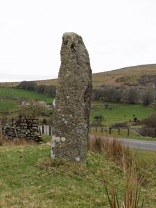
Stone Type: |
Guide
Stone |
|
|
|
|
|
|
|
|
Grid Reference: |
SX/5518/7501 |
|
|
|
|
|
|
|
|
Location: |
Close
to the road, just up the hill to the east of Merrivale Bridge. |
|
|
|
|
|
|
|
|
Inscription: |
'A'
(Ashburton) - 'T' (Tavistock) on the reverse. |
|
|
|
|
|
|
|
|
Notes: |
A
Guidestone to mark the ancient Tavistock/Ashburton track. |
|
|
|
|
|
|
|
|
|
|
|
|
|
|
|
|
|
|
|
|
|
|
|
|
|
|
|
|
|
|
|
|
|
|
|
|
|
|
|
|
|
|
|
|
|
|
|
|
|
|
|
|
|
|
|
|
|
|
|
|
|
|
|
|
|
|
|
|
|
|
|
|
|
|
|
|
|
|
|
|
|
|
Stone Type: |
Milestone |
|
|
|
|
|
|
|
|
|
Grid Reference: |
SX/5805/7288 |
|
|
|
|
|
|
|
|
|
Location: |
Beside
the B3212 at Devil's Bridge, south west of Princetown. |
|
|
|
|
|
|
|
|
|
Inscription: |
Plymouth
14 Miles / Princetown 1. |
|
|
|
|
|
|
|
|
|
|
|
|
|
|
|
|
|
|
|
|
|
|
|
|
|
|
|
|
|
|
|
|
|
|
|
|
|
|
|
|
|
|
|
|
|
|
|
|
|
|
|
|
|
|
|
|
|
|
|
|
|
|
|
|
|
|
|
|
|
|
|
|
|
|
|
|
|
|
|
|
|
|
|
|
|
|
|
|
|
|
|
|
|
|
|
|
|
|
|
|
|
|
|
|
|
|
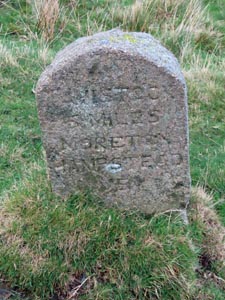
Stone Type: |
Milestone |
|
|
|
|
|
|
|
|
Grid Reference: |
SX/5756/7498 |
|
|
|
|
|
|
|
|
Location: |
On
the northern verge of the B3357 at Rundlestone |
|
|
|
|
|
|
|
|
Inscription: |
Tavistock
6 Miles / Moretonhampstead 14 |
|
|
|
|
|
|
|
|
|
|
|
|
|
|
|
|
|
|
|
|
|
|
|
|
|
|
|
|
|
|
|
|
|
|
|
|
|
|
|
|
|
|
|
|
|
|
|
|
|
|
|
|
|
|
|
|
|
|
|
|
|
|
|
|
|
|
|
|
|
|
|
|
|
|
|
|
|
|
|
|
|
|
|
|
|
|
|
|
|
|
|
|
Stone Type: |
Milestone |
|
|
|
|
|
|
|
|
|
Grid Reference: |
SX/55955/74924 |
|
|
|
|
|
|
|
|
|
Location: |
On
the northern verge of the B3357, 225 yards west of the Four Winds car park
entrance |
|
|
|
|
|
|
|
|
|
|
|
|
|
|
|
|
|
Inscription: |
Tavistock
5 Miles / Moretonhampstead 15 |
|
|
|
|
|
|
|
|
|
|
|
|
|
|
|
|
|
|
|
|
|
|
|
|
|
|
|
|
|
|
|
|
|
|
|
|
|
|
|
|
|
|
|
|
|
|
|
|
|
|
|
|
|
|
|
|
|
|
|
|
|
|
|
|
|
|
|
|
|
|
|
|
|
|
|
Stone Type: |
Boundary
Stone |
|
|
|
|
|
|
Grid Reference: |
SX/57556/74980 |
|
|
|
|
|
|
Location: |
On
the northern verge of the B3357 at Rundlestone |
|
|
|
|
|
|
Inscription: |
Walkhampton
/ Lydford |
| |
|
|
|
|
|
|
|
|
|
|
|
|
|
|
|
|
|
|
|
|
|
|
|
|
|
|
|
|
|
|
|
|
|
| Stone Type: |
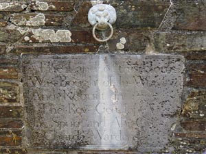
Marker
Stone |
|
|
|
|
|
|
|
| Grid Reference: |
SX/53371/69786 |
|
|
|
|
|
|
|
| Location: |
Built
into a garden wall of the road leading to the church. |
|
|
|
|
|
|
|
| Inscription: |
The
Land of this House / Was bought of in Wayton (Welltown?) / And Rebuilt in
1785 / The Rev. Geo. Jope |
|
|
|
|
|
|
|
| Notes: |
Parts
of the Inscription are now very difficult to read. |
|
|
|
|
|
|
|
|
|
|
|
|
|
|
|
|
|
|
|
|
|
|
|
|
|
|
|
|
|
|
|
|
|
|
|
|
|
|
|
|
|
|
|
|
|
|
|
|
|
|
|
|
|
|
|
|
|
|
|
| |
|
|
|
|
|
|
|
|
|
|
|
|
|
|
|
|
|
|
|
|
|
|
|
|
|
|
|
|
|
|
|
|
|
|
|
|
|
|
|