| |
|
|
|
|
|
|
|
|
|
|
|
|
| |
|
|
|
|
|
|
|
|
|
|
|
|
|
|
|
|
|
|
|
|
District: |
West Devon |
|
|
|
|
|
|
|
|
|
|
|
 |
|
| |
|
|
|
|
|
|
|
|
|
|
|
|
|
|
|
|
|
|
Parish: |
Whitchurch |

|

|
 |
|
|
|
|
| |
|
|
|
|
|
|
|
|
|
|
|
|
|
|
|
|
|
|
|
| |
|
|
|
|
|
|
|
|
|
|
|
|
|
|
|
|
|
|
|
| |
|
|
|
|
|
|
|
|
|
|
|
|
|
|
|
|
|
|
|
| Page
Contents: |
|
| |
17 Boundary Stones |
| |
4 Crosses |
| |
2
Marker Stone |
| |
3
Milestones |
| |
|
| |
|
|
|
|
|
|
|
|
|
|
|
|
|
|
|
|
|
|
| |
|
|
|
|
|
|
|
|
|
|
|
|
|
| |
|
|
|
|
|
|
|
|
|
|
|
|
|
| |
|
|
|
|
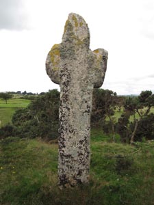
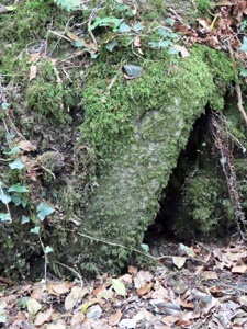
Stone Type: |
Pixies (Wayside) Cross |
| |
|
|
|
|
Grid Reference: |
SX/5012/7367 |
| |
|
|
|
|
Location: |
Amongst the gorse on a raised mound on the Golf Course on Whitchurch Down. |
| |
|
|
|
|
Notes: |
The cross was a marker on the route of the Abbott's Way, across the moor
between the Abbeys at Buckfast and Tavistock. |
| |
|
|
|
|
|
|
|
|
|
| |
|
|
|
|
|
|
|
|
|
|
|
|
|
|
|
|
| |
|
|
|
|
|
|
|
|
|
|
|
|
|
|
|
|
| |
|
|
|
|
|
|
|
|
|
|
|
|
|
|
|
|
|
|
|
|
|
|
|
|
|
|
|
|
|
|
|
|
| |
|
|
|
|
|
|
|
|
|
|
|
|
|
|
|
|
| |
|
|
|
|
|
|
|
|
|
|
|
|
|
|
|
|
|
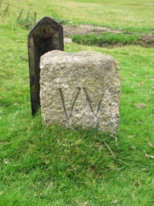
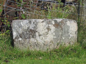
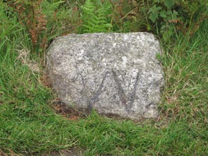
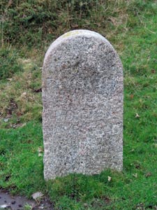
Stone Type: |
Boundary Stone |
|
|
|
|
|
|
|
|
|
Grid Reference: |
SX/4954/7371 |
|
|
|
|
|
|
|
|
|
Location: |
On the north side of the road that runs across Whitchurch Down |
|
|
|
|
|
|
|
|
|
Inscription: |
W (Whitchurch). |
|
|
|
|
|
|
|
|
| Notes: |
Shares
its boundary with Tavistock. |
|
|
|
|
|
|
|
|
| |
|
|
|
|
|
|
|
|
|
|
|
|
|
|
|
|
| |
|
|
|
|
|
|
|
|
|
|
|
|
|
|
|
|
| |
|
|
|
|
|
|
|
|
|
|
|
|
|
|
| |
|
|
|
|
|
|
|
|
|
|
|
|
|
| |
|
|
|
|
|
|
|
|
|
|
|
|
|
|
|
|
| |
|
|
|
|
|
|
|
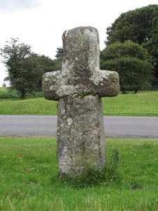
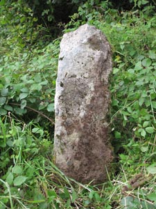
Stone Type: |
Wayside Cross |
| |
|
|
|
|
|
|
|
Grid Reference: |
SX/4929/7386 |
| |
|
|
|
|
|
|
|
Location: |
About 20 metres north of the road that runs across Whitchurch Down. |
| |
|
|
|
|
|
|
|
Notes: |
This cross has undergone substantial repairs and it appears as though the
original head has been fixed onto a newer shaft, but in an upside down
position. |
| |
|
|
|
|
|
|
|
|
|
| |
|
|
|
|
|
|
|
|
|
|
|
|
|
|
|
|
| |
|
|
|
|
|
|
|
|
|
|
|
|
|
|
|
|
|
|
|
|
|
|
|
|
|
|
|
|
|
|
|
|
| |
|
|
|
|
|
|
|
|
|
|
|
|
|
| |
|
|
|
|
|
|
|
|
|
|
|
|
|
|
|
|
|
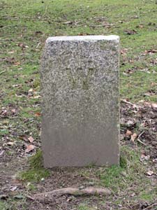
Stone Type: |
Millennium Boundary Stone |
|
|
|
|
|
|
|
|
|
Grid Reference: |
SX/4984/7290 |
|
|
|
|
|
|
|
|
|
Location: |
Set in an area of grass in the centre of Middlemoor, on the outskirts of
Whitchurch. |
|
|
|
|
|
|
|
|
|
Inscription: |
W / MM / T (Whitchurch / Millennium / Tavistock). |
|
|
|
|
|
|
|
|
| |
|
|
|
|
|
|
|
|
|
| |
|
|
|
|
|
|
|
|
|
|
|
|
|
|
|
|
| |
|
|
|
|
|
|
|
|
|
|
|
|
|
|
|
|
| |
|
|
|
|
|
|
|
|
|
|
|
|
|
| |
|
|
|
|
|
|
|
|
|
|
|
|
|
|
|
|
|
|
|
Stone Type: |
Boundary
Stone |
|
|
|
|
|
|
|
Grid Reference: |
SX/5501/7511 |
|
|
|
|
|
|
|
Location: |
Against
the wall/fence on the slip road running down from the Dartmoor Inn at
Merrivale. |
|
|
|
|
|
|
|
Inscription: |
Whitchurch
/ Walkhampton |
|
|
|
|
|
|
|
|
|
|
|
|
|
|
|
|
|
|
|
|
|
|
|
|
|
|
|
|
|
|
|
|
|
|
|
|
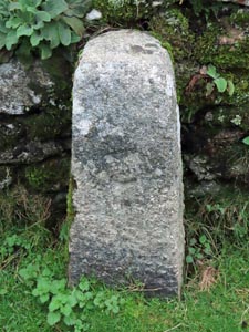
Stone Type: |
Boundary
Stone |
|
|
|
|
|
|
|
|
Grid Reference: |
SX/4922/7395 |
|
|
|
|
|
|
|
|
Location: |
On
the grass, to the north east of the road on Whitchurch Down. |
|
|
|
|
|
|
|
|
Inscription: |
Dartmoor
National Park |
|
|
|
|
|
|
|
| Notes: |
Marks
the boundary of the National Park. |
|
|
|
|
|
|
|
|
|
|
|
|
|
|
|
|
|
|
|
|
|
|
|
|
|
|
|
|
|
|
|
|
|
|
|
|
|
|
|
|
|
|
|
|
|
|
|
|
|
|
|
|
|
|
|
|
|
|
|
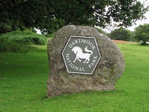
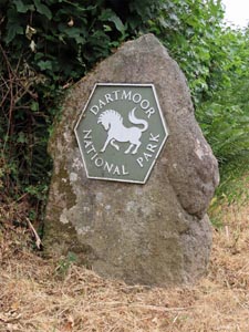
Stone Type: |
Boundary
Stone |
|
|
|
|
|
|
|
|
Grid Reference: |
SX/4984/7378 |
|
|
|
|
|
|
|
|
Location: |
To
the north of the road that runs across Whitchurch Down. |
|
|
|
|
|
|
|
|
Inscription: |
W
(Whitchurch) |
|
|
|
|
|
|
|
|
Notes: |
Shares
its boundary with Tavistock. |
|
|
|
|
|
|
|
|
|
|
|
|
|
|
|
|
|
|
|
|
|
|
|
|
|
|
|
|
|
|
|
|
|
|
|
|
|
|
|
|
|
|
|
|
|
|
|
|
|
|
|
|
|
|
|
|
|
|
|
|
|
|
|
|
|
|
|
|
|
|
|
|
|
|
|
|
|
|
|
|
|
|
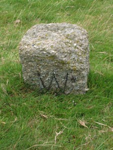
Stone Type: |
Boundary
Stone |
|
|
|
|
|
|
|
|
|
Grid Reference: |
SX/5010/7383 |
|
|
|
|
|
|
|
|
|
Location: |
Near
the 7th Tee of the Golf Course on Whitchurch Down. |
|
|
|
|
|
|
|
|
|
Inscription: |
W
(Whitchurch) |
|
|
|
|
|
|
|
|
| Notes: |
Shares
its boundary with Tavistock. |
|
|
|
|
|
|
|
|
|
|
|
|
|
|
|
|
|
|
|
|
|
|
|
|
|
|
|
|
|
|
|
|
|
|
|
|
|
|
|
|
|
|
|
|
|
|
|
|
|
|
|
|
|
|
|
|
|
|
|
|
|
|
|
|
|
|
|
|
|
|
|
|
|
|
|
|
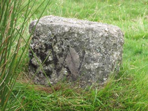
Stone Type: |
Boundary
Stone |
|
|
|
|
|
|
|
Grid Reference: |
SX/5035/7388 |
|
|
|
|
|
|
|
Location: |
On
a small mound, 8 yards west of the unclassified road. |
|
|
|
|
|
|
|
Inscription: |
W
(Whitchurch) |
|
|
|
|
|
|
|
Notes: |
Shares
its boundary with Tavistock. |
|
|
|
|
|
|
|
|
|
|
|
|
|
|
|
|
|
|
|
|
|
|
|
|
|
|
|
Stone Type: |
Boundary
Stone |
|
|
|
|
|
|
|
|
Grid Reference: |
SX/5055/7404 |
|
|
|
|
|
|
|
|
Location: |
On
the northern verge of the unclassified road. |
|
|
|
|
|
|
|
|
Inscription: |
W
(Whitchurch) |
|
|
|
|
|
|
|
|
|
|
|
|
|
|
|
|
|
|
|
|
|
|
|
|
|
|
|
|
|
|
|
|
|
|
|
|
|
|
|
|
|
|
|
|
|
|
|
|
|
|
|
|
|
|
|
|
|
|
|
|
|
|
|
|
|
|
|
|
Stone Type: |
Boundary
Stone |
|
|
|
|
|
|
|
|
Grid Reference: |
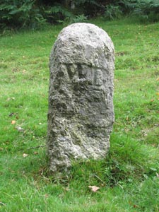
SX/5125/7518 |
|
|
|
|
|
|
|
|
Location: |
On
the grass verge at the entrance to Collaton. |
|
|
|
|
|
|
|
|
Inscription: |
W
(Whitchurch) - no longer visible. |
|
|
|
|
|
|
|
|
Notes: |
Shares
its boundary with Peter Tavy and Tavistock. |
|
|
|
|
|
|
|
|
|
|
|
|
|
|
|
|
|
|
|
|
|
|
|
|
|
|
|
|
|
|
|
|
|
|
|
|
|
|
|
|
|
|
|
|
|
|
|
|
|
|
|
|
|
|
|
|
|
|
|
|
|
|
|
|
|
|
|
|
|
|
|
|
|
|
|
|
|
|
|
|
|
|
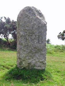
Stone Type: |
Boundary
Stone |
|
|
|
|
|
|
|
|
|
Grid Reference: |
SX/5171/7180 |
|
|
|
|
|
|
|
|
|
Location: |
On
the north east verge of the road across Plaster Down |
|
|
|
|
|
|
|
|
|
Inscription: |
W
B (Whitchurch Bounds) |
|
|
|
|
|
|
|
|
| Notes: |
Shares
its boundary with Sampford Spiney |
|
|
|
|
|
|
|
|
|
|
|
|
|
|
|
|
|
|
|
|
|
|
|
|
|
|
|
|
|
|
|
|
|
|
|
|
|
|
|
|
|
|
|
|
|
|
|
|
|
|
|
|
|
|
|
|
|
|
|
|
|
|
|
|
|
|
|
|
|
|
|
|
|
|
|
|
|
|
|
|
|
|
|
|
|
|
|
|
|
|
|
|
|
|
|
|
Stone Type: |
Boundary
Stone |
|
|
|
|
|
|
|
|
Grid Reference: |
SX/5165/7169 |
|
|
|
|
|
|
|
|
Location: |
On
the eastern verge of the unclassified road to Horrabridge. |
|
|
|
|
|
|
|
|
Inscription: |
W
B (Whitchurch Bounds) |
|
|
|
|
|
|
|
|
Notes: |
Shares
its boundary with Sampford Spiney |
|
|
|
|
|
|
|
|
|
|
|
|
|
|
|
|
|
|
|
|
|
|
|
|
|
|
|
|
|
|
|
|
|
|
|
|
|
|
|
|
|
|
|
|
|
|
|
|
|
|
|
|
|
|
|
|
|
|
|
|
|
|
|
|
|
|
|
|
|
|
|
|
|
|
|
|
|
|
|
|
|
|
Stone Type: |
Boundary
Stone |
|
|
|
|
|
|
|
|
|
Grid Reference: |
SX/5164/7142 |
|
|
|
|
|
|
|
|
|
Location: |
On
the western verge of the unclassified road to Horrabridge. |
|
|
|
|
|
|
|
|
|
Inscription: |
W
B (Whitchurch Bounds) |
|
|
|
|
|
|
|
|
| Notes: |
Shares
its boundary with Sampford Spiney |
|
|
|
|
|
|
|
|
|
|
|
|
|
|
|
|
|
|
|
|
|
|
|
|
|
|
|
|
|
|
|
|
|
|
|
|
|
|
|
|
|
|
|
|
|
|
|
|
|
|
|
|
|
|
|
|
|
|
|
|
|
|
|
|
|
|
|
|
|
|
|
|
|
|
|
|
|
|
|
|
|
|
|
|
|
|
|
|
|
|
|
|
|
|
|
|
Stone Type: |
Boundary
Stone |
|
|
|
|
|
|
|
|
Grid Reference: |
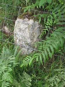
SX/5178/7132 |
|
|
|
|
|
|
|
|
Location: |
Tucked
under the hedge, to the east of the unclassified road to Horrabridge. |
|
|
|
|
|
|
|
|
Inscription: |
W
B (Whitchurch Bounds) |
|
|
|
|
|
|
|
|
Notes: |
Shares
its boundary with Sampford Spiney |
|
|
|
|
|
|
|
|
|
|
|
|
|
|
|
|
|
|
|
|
|
|
|
|
|
|
|
|
|
|
|
|
|
|
|
|
|
|
|
|
|
|
|
|
|
|
|
|
|
|
|
|
|
|
|
|
|
|
|
|
|
|
|
|
|
|
|
|
|
|
|
|
|
|
|
|
|
|
|
|
|
|
Stone Type: |
Churchyard
Cross |
|
|
|
|
|
|
|
|
|
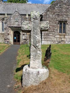
Grid Reference: |
SX/49299/72683 |
|
|
|
|
|
|
|
|
|
Location: |
Inside
the main entrance to Whitchurch Churchyard |
|
|
|
|
|
|
|
|
|
Inscription: |
Erected
in / Memory of / William / Henry / Mudge / 1981 / By / Parishioners |
|
|
|
|
|
|
|
|
| Notes: |
For
more information on this cross, see dartmoor-crosses.org.uk |
|
|
|
|
|
|
|
|
|
|
|
|
|
|
|
|
|
|
|
|
|
|
|
|
|
|
|
|
|
|
|
|
|
|
|
|
|
|
|
|
|
|
|
|
|
|
|
|
|
|
|
|
|
|
|
|
|
|
|
|
|
|
|
|
|
|
|
|
|
|
|
|
|
|
|
|
|
|
|
|
|
|
|
|
|
|
|
|
|
|
|
|
|
|
|
|
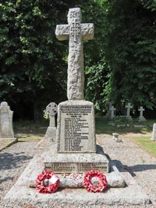
Stone Type: |
Memorial
Cross |
|
|
|
|
|
|
|
|
Grid Reference: |
SX/49331/72732 |
|
|
|
|
|
|
|
|
Location: |
In
the churchyard, above the road wall behind the church. |
|
|
|
|
|
|
|
|
Inscription: |
To
the Undying Memory of Our / Brave Whitchurch Parishioners / Who Laid Down
their Lives / In the Great War / 1914 - 1918 / 1939 - 1945. |
|
|
|
|
|
|
|
|
Notes: |
For
more information on this cross, see dartmoor-crosses.org.uk |
|
|
|
|
|
|
|
|
|
|
|
|
|
|
|
|
|
|
|
|
|
|
|
|
|
|
|
|
|
|
|
|
|
|
|
|
|
|
|
|
|
|
|
|
|
|
|
|
|
|
|
|
|
|
|
|
|
|
|
|
|
|
|
|
|
|
|
|
|
|
|
|
|
|
|
|
|
|
|
|
|
|
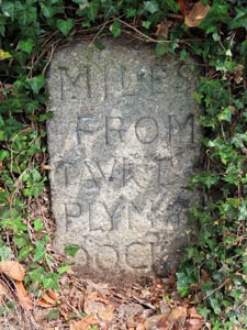
Stone Type: |
Milestone |
|
|
|
|
|
|
|
|
|
Grid Reference: |
SX/48531/73096 |
|
|
|
|
|
|
|
|
|
Location: |
Set
into the north-east wall of Whitchurch Road, opposite two telegraph poles
close together. |
|
|
|
|
|
|
|
|
|
Inscription: |
Miles /
From / Tavk 1 / Plymo & / Dock / XIII |
|
|
|
|
|
|
|
|
|
|
|
|
|
|
|
|
|
|
|
|
|
|
|
|
|
|
|
|
|
|
|
|
|
|
|
|
|
|
|
|
|
|
|
|
|
|
|
|
|
|
|
|
|
|
|
|
|
|
|
|
|
|
|
|
|
|
|
|
|
|
|
|
|
|
|
|
|
|
|
|
|
|
|
|
|
|
|
|
|
|
|
|
|
|
|
|
|
|
|
|
|
|
|
|
|
|
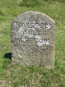
Stone Type: |
Milestone |
|
|
|
|
|
|
|
|
Grid Reference: |
SX/5450/7504 |
|
|
|
|
|
|
|
|
Location: |
Beside
the B3357, just to the west of the entrance to Merrivale Quarry. |
|
|
|
|
|
|
|
|
Inscription: |
Tavistock
4 Miles / Moretonhampstead 16 |
|
|
|
|
|
|
|
|
|
|
|
|
|
|
|
|
|
|
|
|
|
|
|
|
|
|
|
|
|
|
|
|
|
|
|
|
|
|
|
|
|
|
|
|
|
|
|
|
|
|
|
|
|
|
|
|
|
|
|
|
|
|
|
|
|
|
|
|
|
|
|
|
|
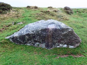
Stone Type: |
Marker
Stone |
|
|
|
|
|
|
|
|
Grid Reference: |
SX/5398/7505 |
|
|
|
|
|
|
|
|
Location: |
In
the Rees Jeffreys Car Park, Merrivale. |
|
|
|
|
|
|
|
|
Inscription: |
This
viewpoint parking area has been constructed by the Rees Jeffreys Road
Fund. |
|
|
|
|
|
|
|
|
|
|
|
|
|
|
|
|
|
|
|
|
|
|
|
|
|
|
|
|
|
|
|
|
|
|
|
|
|
|
|
|
|
|
|
|
|
|
|
|
|
|
|
|
|
|
|
|
|
|
|
|
|
|
|
|
|
|
|
|
Stone Type: |
Boundary
Stone |
|
|
|
|
|
|
|
|
Grid Reference: |
SX/54959/75167 |
|
|
|
|
|
|
|
|
Location: |
Against
the wall on the slip road running down from the Dartmoor Inn to the old
Merrivale Bridge |
|
|
|
|
|
|
|
|
|
|
|
|
|
|
|
|
Inscription: |
C
- (County Bridge Stone - see note on Home Page) |
|
|
|
|
|
|
|
|
|
|
|
|
|
|
|
|
|
|
|
|
|
|
|
|
|
|
|
|
|
|
|
|
|
|
|
|
|
|
|
|
|
|
|
|
|
|
|
|
|
|
|
|
|
|
|
|
|
|
|
|
|
|
|
|
|
|
|
|
|
|
|
|
|
|
|
|
|
|
|
|
|
|
Stone Type: |
Milestone |
|
|
|
|
|
|
|
|
|
Grid Reference: |
SX/52944/75183 |
|
|
|
|
|
|
|
|
|
Location: |
On
the northern verge of the B3357, near the Pork Hill car park. |
|
|
|
|
|
|
|
|
|
Inscription: |
Tavistock
3 Miles / Moretonhampstead 17 |
|
|
|
|
|
|
|
|
|
|
|
|
|
|
|
|
|
|
|
|
|
|
|
|
|
|
|
|
|
|
|
|
|
|
|
|
|
|
|
|
|
|
|
|
|
|
|
|
|
|
|
|
|
|
|
|
|
|
|
|
|
|
|
|
|
|
|
|
|
|
|
|
|
|
|
|
|
|
|
|
|
|
|
|
|
|
|
|
|
|
|
|
|
|
|
|
|
|
|
|
|
|
|
|
|
|
Stone Type: |
Marker
Stone |
|
|
|
|
|
|
|
|
Grid Reference: |
SX/53010/75130 |
|
|
|
|
|
|
|
|
Location: |
At
the western end of the Pork Hill car park |
|
|
|
|
|
|
|
|
Inscription: |
The
Royal Town Planning Institute / To commemorate the 70th anniversary of the
Institute and / to contribute to the enjoyment of the Countryside |
|
|
|
|
|
|
|
|
Notes: |
The
monument maps details of the panoramic view from the stone. |
|
|
|
|
|
|
|
|
|
|
|
|
|
|
|
|
|
|
|
|
|
|
|
|
|
|
|
|
|
|
|
|
|
|
|
|
|
|
|
|
|
|
|
|
|
|
|
|
|
|
|
|
|
|
|
|
|
|
|
|
|
|
|
|
|
|
|
|
|
|
|
|
|
|
|
|
|
|
|
|
|
|
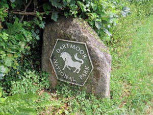
Stone Type: |
Boundary
Stone |
|
|
|
|
|
|
|
|
|
Grid Reference: |
SX/49459/71619 |
|
|
|
|
|
|
|
|
|
Location: |
On
the grass verge of the minor road in Grenofen |
|
|
|
|
|
|
|
|
|
Inscription: |
Dartmoor
National Park |
|
|
|
|
|
|
|
|
| Notes: |
Marks
the boundary of the National Park. |
|
|
|
|
|
|
|
|
|
|
|
|
|
|
|
|
|
|
|
|
|
|
|
|
|
|
|
|
|
|
|
|
|
|
|
|
|
|
|
|
|
|
|
|
|
|
|
|
|
|
|
|
|
|
|
|
|
|
|
|
|
|
|
|
|
|
|
|
|
|
|
|
|
|
|
|
Stone Type: |
Boundary
Stone |
|
|
|
|
|
|
|
Grid Reference: |
SX/49448/71500 |
|
|
|
|
|
|
|
Location: |
On
the grass verge of the A386 in Grenofen |
|
|
|
|
|
|
|
Inscription: |
Dartmoor
National Park |
|
|
|
|
|
|
|
Notes: |
Marks
the boundary of the National Park. |
|
|
|
|
|
|
|
|
|
|
|
|
|
|
|
|
|
|
|
|
|
|
|
|
|
|
|
|
|
|
|
|
|
|
|
|
|
|
|
|
|
|
|
|
|
|
Stone Type: |
Boundary
Stone |
|
|
|
|
|
|
|
|
|
Grid Reference: |
SX/49025/71066 |
|
|
|
|
|
|
|
|
|
Location: |
At
the side of the road to the north of Grenofen Bridge |
|
|
|
|
|
|
|
|
|
Inscription: |
C
- (County Bridge Stone - see note on Home Page) |
|
|
|
|
|
|
|
|
|
|
|
|
|
|
|
|
|
|
|
|
|
|
|
|
|
|
|
|
|
|
|
|
|
|
|
|
|
|
|
|
|
|
|
|
|
|
|
|
|
|
|
|
|
|
|
|
|
|
|
|
|
|
|
|
|
|
|
|
|
|
|
|
|
|
|
|
|
|
|
|
|
|
|
|
|
|
|
|
|
|
|
|
|
|
|
|
|
|
|
|
|
|
|
|
|
|
| |
|
|
|
|
|
|
|
|
|
|
|
|
|
|
|
|
|
|
|
|
|
|
|
|
|
|
|
|
|
|
|
|
|
|
|
|
|
|
|