| |
|
|
|
|
|
|
|
|
|
|
|
|
| |
|
|
|
|
|
|
|
|
|
|
|
|
|
|
|
|
|
|
|
|
District: |
Exeter |
|
|
|
|
|
|
|
|
|
|
|
 |
|
| |
|
|
|
|
|
|
|
|
|
|
|
|
|
|
|
|
|
|
Parish: |
Heavitree |
 |
 |
 |
|
|
|
|
| |
|
|
|
|
|
|
|
|
|
|
|
|
|
|
|
|
|
|
|
| |
|
|
|
|
|
|
|
|
|
|
|
|
|
|
|
|
|
|
|
| |
|
|
|
|
|
|
|
|
|
|
|
|
|
|
|
|
|
|
|
| Page
Contents: |
|
| |
9 Boundary Stones |
| |
1 Cross |
| |
3
Marker Stones |
| |
1
Milestone |
| |
|
| |
|
|
|
|
|
|
|
|
|
|
|
|
|
|
|
|
|
|
|
|
| |
|
|
|
|
|
|
|
|
|
|
|
|
|
|
|
|
| |
|
|
|
|
|
|
|
|
|
|
|
|
|
| |
|
|
|
|
|
|
|
|
|
|
|
|
| |
|
|
|
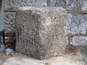
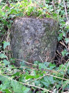
Stone Type: |
Boundary Stone |
| |
|
|
|
Grid Reference: |
SX/9344/9251 |
| |
|
|
|
Location: |
On the north side of Heavitree Road at the Livery Dole Junction, set back
against the wall beside a bench. |
| |
|
|
|
|
|
|
Inscription: |
St Sidwells P / Heavitree P |
| |
|
|
|
|
|
|
|
|
|
|
|
|
|
|
|
|
|
|
|
|
|
|
|
|
|
|
|
|
|
|
|
|
|
|
|
|
|
|
|
|
|
|
|
|
|
|
|
|
|
|
|
|
|
|
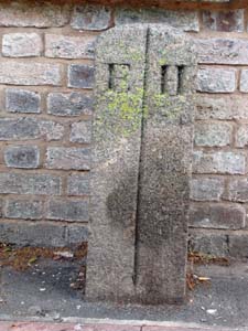
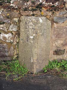
Stone Type: |
Boundary Stone |
|
|
|
|
|
|
|
|
|
Grid Reference: |
SX/9338/9269 |
|
|
|
|
|
|
|
|
|
Location: |
On the east side of Polsloe Road, set back against the wall near the
pedestrian crossing. |
|
|
|
|
|
|
|
|
|
Inscription: |
E / H (Exeter / Heavitree) |
|
|
|
|
|
|
|
|
|
|
|
|
|
|
|
|
|
|
|
|
|
|
|
|
|
|
|
|
|
|
|
|
|
|
|
|
|
|
|
|
|
|
|
|
|
|
|
|
|
|
|
|
|
|
|
|
|
|
|
|
|
|
|
|
|
|
|
|
|
|
|
|
|
|
|
|
|
|
|
| |
|
|
|
|
|
|
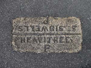
Stone Type: |
Boundary Stone |
| |
|
|
|
|
|
|
Grid Reference: |
SX/9310/9388 |
| |
|
|
|
|
|
|
Location: |
Set into the floor of the traffic island to the north exit of the Old
Tiverton Road roundabout. |
| |
|
|
|
|
|
|
Inscription: |
Heavitree P / St Sidwells P |
| |
|
|
|
|
|
|
|
|
|
|
|
|
|
|
|
|
|
|
|
|
|
|
|
|
|
|
|
|
|
|
|
|
|
|
|
|
|
|
|
|
|
|
|
|
|
|
|
|
|
|
|
|
|
|
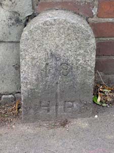
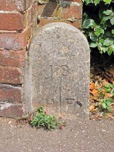
Stone Type: |
Boundary Stone |
|
|
|
|
|
|
|
|
|
Grid Reference: |
SX/9311/9262 |
|
|
|
|
|
|
|
|
|
Location: |
On the south side of Heavitree Road, set back against the wall at the St
Luke's Campus of Exeter University. |
|
|
|
|
|
|
|
|
|
Inscription: |
1 8 / H P (Heavitree Parish) |
|
|
|
|
|
|
|
|
|
|
|
|
|
|
|
|
|
|
|
|
|
|
|
|
|
|
|
|
|
|
|
|
|
|
|
|
|
|
|
|
|
|
|
|
|
|
|
|
|
|
|
|
|
|
|
|
|
|
|
|
|
|
|
|
|
|
|
|
|
|
|
|
|
|
|
|
|
|
|
|
|
| |
|
|
|
|
|
|
|
|
|
|
|
|
|
|
|
|
| |
|
|
|
|
|
|
|
Stone Type: |
Boundary Stone |
| |
|
|
|
|
|
|
|
Grid Reference: |
SX/9297/9239 |
| |
|
|
|
|
|
|
|
Location: |
On the north side of Magdalen Road, at the junction with College Avenue. |
| |
|
|
|
|
|
|
|
Inscription: |
1 8 / H P (Heavitree Parish) |
| |
|
|
|
|
|
|
|
Notes: |
An Ordnance Survey Benchmark has been cut into the end of the brick wall
adjacent to the Boundary Stone. |
| |
|
|
|
|
|
|
|
|
|
|
|
|
|
|
|
|
| |
|
|
|
|
|
|
|
|
|
|
|
|
|
|
|
|
|
|
|
|
|
|
|
|
|
|
|
|
|
|
|
|
|
|
|
|
|
|
|
|
|
|
|
|
|
|
|
|
|
|
|
|
|
|
|
|
|
|
|
|
|
|
|
|
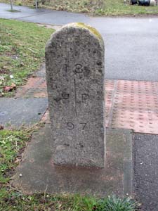
Stone Type: |
Boundary Stone |
|
|
|
|
|
|
|
|
|
Grid Reference: |
SX/9653/9304 |
|
|
|
|
|
|
|
|
|
Location: |
Set into the pavement, beside the traffic lights, on the north west side of
Honiton Road (A30), between Cumberland Way and the M5 slip road. |
|
|
|
|
|
|
|
|
|
Inscription: |
18 - HP - 97; (Heavitree Parish) |
|
|
|
|
|
|
|
|
|
|
|
|
|
|
|
|
|
|
|
|
|
|
|
|
|
|
|
|
|
|
|
|
|
|
|
|
|
|
|
|
|
|
|
|
|
|
|
|
|
|
|
|
|
|
|
|
|
|
|
|
|
|
|
|
|
|
|
| |
|
|
|
|
|
|
|
|
|
|
|
|
|
| |
|
|
|
|
|
|
|
|
|
|
|
|
|
|
|
|
| |
|
|
|
|
|
|
|
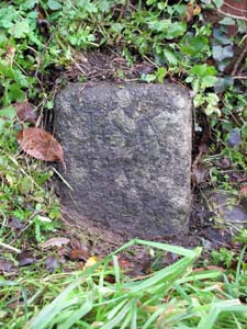
Stone Type: |
Boundary Stone |
| |
|
|
|
|
|
|
|
Grid Reference: |
SX/967/908 |
| |
|
|
|
|
|
|
|
Location: |
On the east side of Clyst Road, beside the signpost at the Old Rydon Lane
Junction. |
| |
|
|
|
|
|
|
|
Notes: |
The inscription is now illegible, but it is understood that this stone marks
the boundary between the parishes of Topsham and Heavitree. |
| |
|
|
|
|
|
|
|
|
|
| |
|
|
|
|
|
|
|
|
|
|
|
|
|
|
|
|
| |
|
|
|
|
|
|
|
|
|
|
|
|
|
|
|
|
|
|
|
|
|
|
|
|
|
|
|
|
|
|
|
|
|
|
|
|
|
|
|
|
|
|
|
|
|
|
|
|
|
|
|
|
|
|
|
|
|
|
|
|
|
|
|
|
Stone Type: |
Boundary Stone |
|
|
|
|
|
|
|
|
|
Grid Reference: |
SX/9707/9112 |
|
|
|
|
|
|
|
|
|
Location: |
At the western end and standing against the northern parapet of the old
bridge to Clyst St Mary. |
|
|
|
|
|
|
|
|
|
Inscription: |
Heavitree P / St Mary Clyst P |
|
|
|
|
|
|
|
|
|
|
|
|
|
|
|
|
|
|
|
|
|
|
|
|
|
|
|
|
|
|
|
|
|
|
|
|
|
|
|
|
|
|
|
|
|
|
|
|
|
|
|
|
|
|
|
|
|
|
|
|
|
|
|
|
|
|
|
|
|
|
|
|
|
|
|
|
|
|
|
|
|
| |
|
|
|
|
|
|
|
|
|
|
|
|
|
|
|
|
| |
|
|
|
|
|
|
|
Stone Type: |
Boundary Stone |
| |
|
|
|
|
|
|
|
Grid Reference: |
SX/9407/9618 |
| |
|
|
|
|
|
|
|
Location: |
The stone is set deep into the hedge behind the 30mph sign, at the Stoke
Post crossroads, on the west side of the road. |
| |
|
|
|
|
|
|
|
Notes: |
The inscription is now illegible, but it is understood that it marks the
boundary between the parishes of Stoke Canon and Heavitree. |
| |
|
|
|
|
|
|
|
|
|
| |
|
|
|
|
|
|
|
|
|
|
|
|
|
|
|
|
| |
|
|
|
|
|
|
|
|
|
|
|
|
|
|
|
|
|
|
|
|
|
|
|
|
|
|
|
|
|
|
|
|
| |
|
|
|
|
|
|
|
|
|
|
|
|
|
| |
|
|
|
|
|
|
|
|
|
|
|
|
|
|
|
|
|
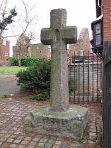
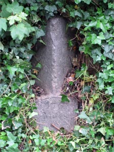
Stone Type: |
Chapel Cross |
|
|
|
|
|
|
|
|
|
Grid Reference: |
SX/9460/9194 |
|
|
|
|
|
|
|
|
|
Location: |
Just inside the entrance to the old St Loye's Chapel site, off Rifford Road. |
|
|
|
|
|
|
|
|
|
Notes: |
The ruins of St Loye's Chapel, with 3 main walls still standing, are set
back behind the cross. |
|
|
|
|
|
|
|
|
|
|
|
|
|
|
|
|
|
|
|
|
|
|
|
|
|
|
|
|
|
|
|
|
|
|
|
|
|
|
|
|
|
|
|
|
|
|
|
|
|
|
|
|
| |
|
|
|
|
|
|
|
|
|
|
|
|
|
|
|
|
|
|
|
|
|
|
|
|
|
|
|
|
|
|
|
|
|
|
|
|
|
|
|
|
|
|
|
|
|
|
|
|
|
|
|
|
|
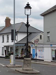
Stone Type: |
Marker
Lamp Post |
|
|
|
|
|
|
|
|
Grid Reference: |
SX/9382/9242 |
|
|
|
|
|
|
|
|
Location: |
At
the junction of North Street with Fore Street, Heavitree. |
|
|
|
|
|
|
|
|
Inscription: |
Presented
to his Native Parish / J.R. Nethercott Esq. / Chairman of the Council
1911-12. |
|
|
|
|
|
|
|
|
|
|
|
|
|
|
|
|
|
|
|
|
|
|
|
|
|
|
|
|
|
|
|
|
|
|
|
|
|
|
|
|
|
|
|
|
|
|
|
|
|
|
|
|
|
|
|
|
|
|
|
|
|
|
|
|
|
|
|
|
|
|
|
|
|
|
|
|
|
|
|
|
|
|
|
|
|
|
|
|
|
|
|
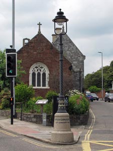
Stone Type: |
Marker
Lamp Post |
|
|
|
|
|
|
|
|
|
Grid Reference: |
SX/9358/9244 |
|
|
|
|
|
|
|
|
|
Location: |
At
the junction of Fore Street, Heavitree and Magdalen Road. |
|
|
|
|
|
|
|
|
|
Inscription: |
Charles
George Gordon / 26th January 1885. |
|
|
|
|
|
|
|
|
| Notes: |
"Gordon
of Khartoum" was friendly with the Reverend Barnes, vicar of the local
Parish Church. |
|
|
|
|
|
|
|
|
|
|
|
|
|
|
|
|
|
|
|
|
|
|
|
|
|
|
|
|
|
|
|
|
|
|
|
|
|
|
|
|
|
|
|
|
|
|
|
|
|
|
|
|
|
|
|
|
|
|
|
|
|
|
|
|
|
|
|
|
|
|
|
|
|
|
|
|
|
|
|
|
|
|
|
|
|
|
|
|
|
|
|
|
|
|
|
|
Stone Type: |
Milestone |
|
|
|
|
|
|
|
|
Grid Reference: |
SX/9425/9237 |
|
|
|
|
|
|
|
|
Location: |
Set
back into the roadside wall opposite No. 149 Fore Street, Heavitree. |
|
|
|
|
|
|
|
|
Inscription: |
15 Miles to Honiton / 1 Mile to Exeter / 175 Miles to London |
|
|
|
|
|
|
|
|
|
|
|
|
|
|
|
|
|
|
|
|
|
|
|
|
|
|
|
|
|
|
|
|
|
|
|
|
|
|
|
|
|
|
|
|
|
|
|
|
|
|
|
|
|
|
|
|
|
|
|
|
|
|
|
|
|
|
|
|
|
|
|
|
|
|
|
|
|
|
|
|
|
|
|
|
|
|
|
|
|
|
|
|
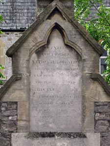
Stone Type: |
Marker
Stone |
|
|
|
|
|
|
|
|
|
Grid Reference: |
SX/93029/92662 |
|
|
|
|
|
|
|
|
|
Location: |
Heavitree
Road, above the entrance gates to the St Luke's Campus. |
|
|
|
|
|
|
|
|
|
Inscription: |
To
Extend and Improve National Education According to the Doctrine . . . |
|
|
|
|
|
|
|
|
| Notes: |
The
rest of the inscription has now become eroded and illegible. |
|
|
|
|
|
|
|
|
|
|
|
|
|
|
|
|
|
|
|
|
|
|
|
|
|
|
|
|
|
|
|
|
|
|
|
|
|
|
|
|
|
|
|
|
|
|
|
|
|
|
|
|
|
|
|
|
|
|
|
|
|
|
|
|
|
|
|
|
|
|
|
|
|
|
|
|
|
|
|
|
|
|
|
|
|
|
|
|
|
|
|
|
|
|
|
|
| |
|
|
|
|
|
|
|
|
|
|
|
|
|
|
|
|
|
|
|
|
|
|
|
|
|
|
|
|
|
|
|
|
|
|
|
|
|
|
|