|
Devon Marker Stones |

|
|||||||||||||||||||||
 |
 |
 |
 |
 |
 |
 |
 |
|
||||||||||||||||||||||||||||||||||||||||||
| District: | Exeter |
|
||||||||||||||||||||||||||||||||||||||||
| Parish: | St Leonards | |||||||||||||||||||||||||||||||||||||||||
|
|
|||||||||||||||||||||||||||||||||||||||||
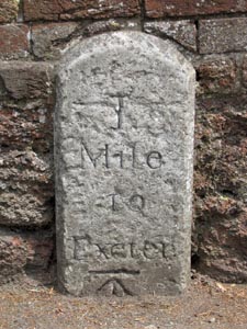
| Stone Type: | Milestone | |||||||||||||||||||||||||||||||||||||||||
| Grid Reference: | SX/9358/9098 | |||||||||||||||||||||||||||||||||||||||||
| Location: | Built into the garden wall of a property on the north east side of Topsham Road next to the bus stop. | |||||||||||||||||||||||||||||||||||||||||
| Inscription: | 1 Mile to Exeter | |||||||||||||||||||||||||||||||||||||||||
| Notes: | The stone also has an Ordnance Survey Benchmark, which is now almost buried beneath the tarmac of the pavement. | |||||||||||||||||||||||||||||||||||||||||
|
||||||||||||||||||||||||||||||||||||||||||
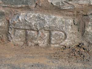
| Stone Type: | Boundary Stone | |||||||||||||||||||||||||||||||||||||||||
| Grid Reference: | SX/9290/9157 | |||||||||||||||||||||||||||||||||||||||||
| Location: | Built into the base of the wall of the County Hall grounds, about 50 metres from the main entrance and 6 metres from the lamppost. | |||||||||||||||||||||||||||||||||||||||||
| Inscription: | T B or TP or TR (Topsham Bounds / Parish / Road) | |||||||||||||||||||||||||||||||||||||||||
| Notes: | The inscription can only be guessed at as the lower half is now buried beneath the tarmac of the pavement. |
|
||||||||||||||||||||||||||||||||||||||||
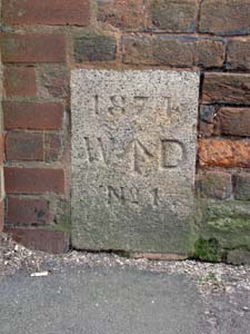
| Stone Type: | War Department Boundary Stone | |||||||||||||||||||||||||||||||||||||||||
| Grid Reference: | SX/9338/9141 | |||||||||||||||||||||||||||||||||||||||||
| Location: | Built into the boundary wall of Wyvern Barracks in Barrack Road, just to the right of an old entrance gate. | |||||||||||||||||||||||||||||||||||||||||
| Inscription: | 1874 W ↑ D No.1. | |||||||||||||||||||||||||||||||||||||||||
| Notes: | The stone marks the boundary of the grounds of Wyvern Barracks. | |||||||||||||||||||||||||||||||||||||||||
|
||||||||||||||||||||||||||||||||||||||||||
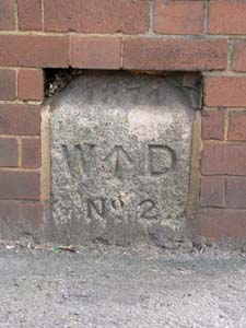
| Stone Type: | War Department Boundary Stone | |||||||||||||||||||||||||||||||||||||||||
| Grid Reference: | SX/9340/9144 | |||||||||||||||||||||||||||||||||||||||||
| Location: | Built into the boundary wall of Wyvern Barracks in Barrack Road, just to the left of an old entrance gate. | |||||||||||||||||||||||||||||||||||||||||
| Inscription: | 1874 W ↑ D No.2. | |||||||||||||||||||||||||||||||||||||||||
| Notes: | The stone marks the boundary of the grounds of Wyvern Barracks. | |||||||||||||||||||||||||||||||||||||||||
|
||||||||||||||||||||||||||||||||||||||||||
| Stone Type: | War Department Boundary Stone | |||||||||||||||||||||||||||||||||||||||||
| Grid Reference: | SX/9352/9170 | |||||||||||||||||||||||||||||||||||||||||
| Location: | On the south west side of Dryden Road, beside the rear entrance gate to a row of houses. | |||||||||||||||||||||||||||||||||||||||||
| Inscription: | 1874 W ↑ D No. 5. | |||||||||||||||||||||||||||||||||||||||||
| Notes: | The stone marks the boundary of the grounds of Wyvern Barracks. | |||||||||||||||||||||||||||||||||||||||||
|
||||||||||||||||||||||||||||||||||||||||||
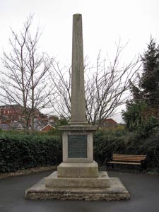
| Stone Type: | Memorial Marker Stone | |||||||||||||||||||||||||||||||||||||||||
| Grid Reference: | SX/9267/9259 | |||||||||||||||||||||||||||||||||||||||||
| Location: | At the junction of Denmark Road with Barnfield Road | |||||||||||||||||||||||||||||||||||||||||
| Notes: | Erected by Harry Hems in remembrance of Thomas Benet M.A. | |||||||||||||||||||||||||||||||||||||||||
|
||||||||||||||||||||||||||||||||||||||||||
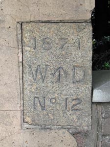
| Stone Type: | War Department Boundary Stone | |||||||||||||||||||||||||||||||||||||||||
| Grid Reference: | SX/9345/9109 | |||||||||||||||||||||||||||||||||||||||||
| Location: | At the south eastern end of the Wyvern Barracks boundary wall in Topsham Road. | |||||||||||||||||||||||||||||||||||||||||
| Inscription: | 1874 W ↑ D No. 12. | |||||||||||||||||||||||||||||||||||||||||
| Notes: | The stone marks the boundary of the grounds of Wyvern Barracks. | |||||||||||||||||||||||||||||||||||||||||
|
||||||||||||||||||||||||||||||||||||||||||
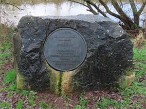
| Stone Type: | Marker Stone | |||||||||||||||||||||||||||||||||||||||||
| Grid Reference: | SX/927/913 | |||||||||||||||||||||||||||||||||||||||||
| Location: | Belle Isle Park, between the main path and the river bank | |||||||||||||||||||||||||||||||||||||||||
| Inscription: | Belle Isle Park was opened on 27 August 1997. | |||||||||||||||||||||||||||||||||||||||||