| |
|
|
|
|
|
|
|
|
|
|
|
|
| |
|
|
|
|
|
|
|
|
|
|
|
|
|
|
|
|
|
|
|
|
District: |
Exeter |
|
|
|
|
|
|
|
|
|
|
|
 |
|
| |
|
|
|
|
|
|
|
|
|
|
|
|
|
|
|
|
|
|
Parish: |
St James |

|

|
 |
|
|
|
|
| |
|
|
|
|
|
|
|
|
|
|
|
|
|
|
|
|
|
|
|
| |
|
|
|
|
|
|
|
|
|
|
|
|
|
|
|
|
|
|
|
| |
|
|
|
|
|
|
|
|
|
|
|
|
|
|
|
|
|
|
|
| Page
Contents: |
|
| |
11 Boundary Stones |
| |
|
| |
|
| |
|
| |
|
| |
|
|
|
|
|
|
|
|
|
|
|
|
|
|
|
|
|
|
|
|
| |
|
|
|
|
|
|
|
|
|
|
|
|
|
| |
|
|
|
|
|
|
|
|
|
|
|
|
| |
|
|
|
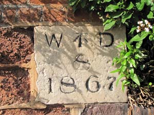
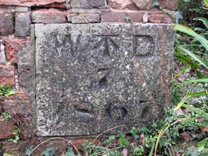
Stone Type: |
War Department Boundary Stone |
| |
|
|
|
Grid Reference: |
SX/9225/9328 |
| |
|
|
|
Location: |
Built into the outer wall of the old Higher Barracks in Blackall Road, at
the junction with Howell Road. |
| |
|
|
|
Inscription: |
W ⭱
D / 8 / 1867 |
| |
|
|
|
|
|
|
Notes: |
The stone marks the boundary of the grounds of the now defunct Higher
Barracks. |
|
|
|
|
|
|
|
|
|
|
|
|
|
|
|
|
|
|
|
|
|
|
|
|
|
|
|
|
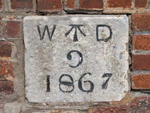
Stone Type: |
War Department Boundary Stone |
|
|
|
|
|
|
|
|
Grid Reference: |
SX/9224/9328 |
|
|
|
|
|
|
|
|
Location: |
Built into the outer wall of the old Higher Barracks in Howell Road, at the
junction with Blackall Road. |
|
|
|
|
|
|
|
|
Inscription: |
W ⭱
D / 9 / 1867 |
|
|
|
|
|
|
|
|
Notes: |
The stone marks the boundary of the grounds of the now defunct Higher
Barracks. |
|
|
|
|
|
|
|
|
|
|
|
|
|
|
|
|
|
|
|
|
|
|
|
|
|
|
|
|
|
|
|
|
|
|
|
|
|
|
|
|
|
|
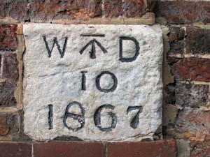
Stone Type: |
War Department Boundary Stone |
| |
|
|
|
|
|
|
Grid Reference: |
SX/9220/9329 |
| |
|
|
|
|
|
|
Location: |
Built into the outer wall of the old Higher Barracks in Howell Road, a few
yards up from the junction with Blackall Road. |
| |
|
|
|
|
|
|
Inscription: |
W ⭱
D / 10 / 1867 |
| |
|
|
|
|
|
|
Notes: |
The stone marks the boundary of the grounds of the now defunct Higher
Barracks. |
|
|
|
|
|
|
|
|
|
|
|
|
|
|
|
| |
|
|
|
|
|
|
|
|
|
|
|
|
| |
|
|
|
|
|
|
|
|
|
|
|
|
|
|
|
|
|
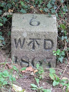
Stone Type: |
War Department Boundary Stone |
|
|
|
|
|
|
|
|
|
Grid Reference: |
SX/9203/9357 |
|
|
|
|
|
|
|
|
|
Location: |
Beside the footpath running through the Hoopern Valley, near the cut through
to the housing estate built on the Barracks site. |
|
|
|
|
|
|
|
|
|
Inscription: |
W ⭱
D / 6 / 1867 |
|
|
|
|
|
|
|
|
|
Notes: |
The stone marks the boundary of the grounds of the now defunct Higher
Barracks. |
|
|
|
|
|
|
|
|
| |
|
|
|
|
|
|
|
|
|
|
|
|
|
|
|
|
| |
|
|
|
|
|
|
|
|
|
|
|
|
|
|
|
|
| |
|
|
|
|
|
|
|
|
|
|
|
|
|
|
| |
|
|
|
|
|
|
|
|
|
|
|
|
|
| |
|
|
|
|
|
|
|
|
|
|
|
|
|
|
|
|
| |
|
|
|
|
|
|
|
Stone Type: |
War Department Boundary Stone |
| |
|
|
|
|
|
|
|
Grid Reference: |
SX/9208/9368 |
| |
|
|
|
|
|
|
|
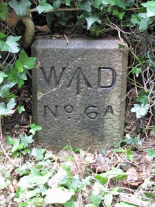
Location: |
Beside the footpath running through the Hoopern Valley, near the cut through
to the children's play area behind the Barracks housing estate. |
| |
|
|
|
|
|
|
|
Inscription: |
W ↑
D / No. 6A |
| |
|
|
|
|
|
|
|
Notes: |
The stone marks the boundary of the grounds of the now defunct Higher
Barracks. |
| |
|
|
|
|
|
|
|
|
|
|
|
|
|
|
|
|
| |
|
|
|
|
|
|
|
|
|
|
|
|
|
|
|
|
|
|
|
|
|
|
|
|
|
|
|
|
|
|
|
| |
|
|
|
|
|
|
|
|
|
|
|
|
|
Stone Type: |
War Department Boundary Stone |
|
|
|
|
|
|
|
|
Grid Reference: |
SX/9209/9330 |
|
|
|
|
|
|
|
|
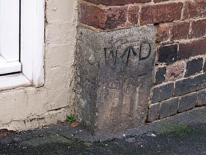
Location: |
Built into the wall beside the doorway of the corner shop in Howell Road. |
|
|
|
|
|
|
|
|
Inscription: |
W ⭱
D / 1867 |
|
|
|
|
|
|
|
|
Notes: |
The stone marks the boundary of the grounds of the now defunct Higher
Barracks. |
|
|
|
|
|
|
|
| |
|
|
|
|
|
|
|
|
|
|
|
|
| |
|
|
|
|
|
|
|
|
|
|
|
|
|
|
|
|
|
|
Stone Type: |
War Department Boundary Stone |
|
|
|
|
|
|
|
Grid Reference: |
SX/9219/9363 |
|
|
|
|
|
|
|
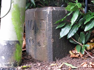
Location: |
Behind
the lamppost at the top of Thornton Hill, between the two paths leading
into the park. |
|
|
|
|
|
|
|
Inscription: |
W
↑ D
No. 6B |
|
|
|
|
|
|
|
Notes: |
The stone marks the boundary of the grounds of the now defunct Higher
Barracks. |
|
|
|
|
|
|
|
|
|
|
|
|
|
|
|
|
|
|
|
|
|
|
|
|
|
|
|
|
|
|
|
|
|
|
|
|
|
|
|
|
|
|
|
|
|
|
Stone Type: |
War Department Boundary Stone |
|
|
|
|
|
|
|
|
|
Grid Reference: |
SX/9219/9362 |
|
|
|
|
|
|
|
|
|
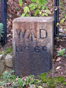
Location: |
At
the top and on the west side of Thornton Hill, in front of the park
railings. |
|
|
|
|
|
|
|
|
|
Inscription: |
W
↑
D No. 6C |
|
|
|
|
|
|
|
|
|
Notes: |
The stone marks the boundary of the grounds of the now defunct Higher
Barracks. |
|
|
|
|
|
|
|
|
|
|
|
|
|
|
|
|
|
|
|
|
|
|
|
|
|
|
|
|
|
|
|
|
|
|
|
|
|
|
|
|
|
|
|
|
|
|
|
|
|
|
|
|
|
|
|
|
|
|
|
|
|
|
|
|
|
|
|
|
|
|
|
|
|
|
|
|
Stone Type: |
War Department Boundary Stone |
|
|
|
|
|
|
|
Grid Reference: |
SX/9215/9360 |
|
|
|
|
|
|
|
Location: |
Built
into the wall of the building in the corner of the lane leading west from
the top of Thornton Hill. |
|
|
|
|
|
|
|
Inscription: |
W
⭱
D 7 1867 |
| |
|
|
|
|
|
|
Notes: |
The stone marks the boundary of the grounds of the now defunct Higher
Barracks. |
|
|
|
|
|
|
|
|
|
|
|
|
|
|
|
|
|
|
|
|
|
|
|
|
|
|
|
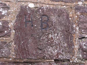
Stone Type: |
Army Barracks Boundary Stone |
|
|
|
|
|
|
|
|
Grid Reference: |
SX/9192/9329 |
|
|
|
|
|
|
|
|
Location: |
Built
into the north wall of Howell Road, in line with the second young tree
from the entrance to the Danes Castle site. |
|
|
|
|
|
|
|
|
Inscription: |
H
B (Higher Barracks) |
|
|
|
|
|
|
|
|
|
|
|
|
|
|
|
|
|
|
|
|
|
|
|
|
|
|
|
|
|
|
|
|
|
|
|
|
|
|
|
|
|
|
|
|
|
|
|
|
|
|
|
|
|
|
|
|
|
|
|
|
|
|
|
|
|
|
|
|
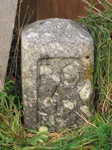
Stone Type: |
Prison Boundary Stone |
|
|
|
|
|
|
|
|
Grid Reference: |
SX/9180/9322 |
|
|
|
|
|
|
|
|
Location: |
In
the lane that runs down the back of Elm Grove Road, from Howell
Road. The stone is beside an electricity pole and 5 yards from a
back door to the prison. |
|
|
|
|
|
|
|
|
Inscription: |
P
C ↑ |
|
|
|
|
|
|
|
|
Notes: |
I've
not been able to discover what the inscription stands for. |
|
|
|
|
|
|
|
|
|
|
|
|
|
|
|
|
|
|
|
|
|
|
|
|
|
|
|
|
|
|
|
|
|
|
|
|
|
|
|
|
|
|
|
|
|
|
|
|
|
|
|
|
|
|
|
|
|
|
|
|
|
|
|
|
|
|
|
|
|
|
|
|
|
|
|
|
|
|
|
|
|
|
|
|
|
|
|
|
| |
|
|
|
|
|
|
|
|
|
|
|
|
|
|
|
|
|
|
|
|
|
|
|
|
|
|
|
|
|
|
|
|
|
|
|
|
|
|
|