| |
|
|
|
|
|
|
|
|
|
|
|
|
| |
|
|
|
|
|
|
|
|
|
|
|
|
|
|
|
|
|
|
|
|
District: |
Teignbridge |
|
|
|
|
|
|
|
|
|
|
|
 |
|
| |
|
|
|
|
|
|
|
|
|
|
|
|
|
|
|
|
|
|
Parish: |
Bovey Tracey |
 |
 |
 |
|
|
|
|
| |
|
|
|
|
|
|
|
|
|
|
|
|
|
|
|
|
|
|
|
| |
|
|
|
|
|
|
|
|
|
|
|
|
|
|
|
|
|
|
|
| |
|
|
|
|
|
|
|
|
|
|
|
|
|
|
|
|
|
|
|
| Page
Contents: |
|
| |
10 Boundary Stones |
| |
1 Bridge Plaque |
| |
7 Crosses |
| |
5 Guide Stones |
| |
7 Marker Stones |
| |
8 Milestones |
|
|
|
|
|
|
|
|
|
|
|
|
|
|
|
|
|
| |
|
|
|
|
|
|
|
|
|
|
|
|
|
| |
|
|
|
|
|
|
|
|
|
|
|
|
|
| |
|
|
|
|
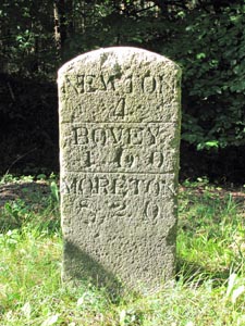
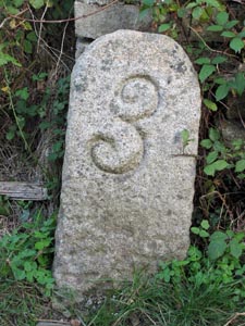
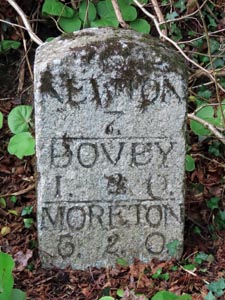
Stone Type: |
Milestone |
| |
|
|
|
|
Grid Reference: |
SX/8235/7623 |
| |
|
|
|
|
Location: |
On the South West side of the A382 on the grass verge. |
| |
|
|
|
|
Inscription: |
Newton 4 - Bovey 1.6.0 - Moreton 8.2.0 |
| |
|
|
|
|
|
|
|
|
|
| |
|
|
|
|
|
|
|
|
|
|
|
|
|
|
|
|
| |
|
|
|
|
|
|
|
|
|
|
|
|
|
|
|
|
| |
|
|
|
|
|
|
|
|
|
|
|
|
|
|
|
|
|
|
|
|
|
|
|
|
|
|
|
|
|
|
|
|
| |
|
|
|
|
|
|
|
|
|
|
|
|
|
|
|
|
| |
|
|
|
|
|
|
|
|
|
|
|
|
|
|
|
|
|
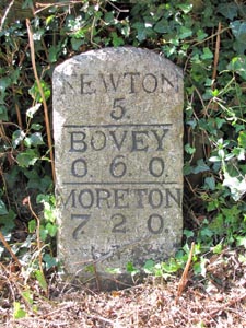
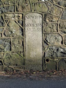
Stone Type: |
Milestone |
|
|
|
|
|
|
|
|
|
Grid Reference: |
SX/8141/7758 |
|
|
|
|
|
|
|
|
|
Location: |
On the South West side of Newton Road, about 10 metres North of the entrance
to the Cricket Field. |
|
|
|
|
|
|
|
|
|
Inscription: |
Newton 5 - Bovey 0.6.0 - Moreton 7.2.0 |
|
|
|
|
|
|
|
|
| |
|
|
|
|
|
|
|
|
|
| |
|
|
|
|
|
|
|
|
|
|
|
|
|
|
|
|
| |
|
|
|
|
|
|
|
|
|
|
|
|
|
|
|
|
| |
|
|
|
|
|
|
|
|
|
|
|
|
|
|
| |
|
|
|
|
|
|
|
|
|
|
|
|
|
| |
|
|
|
|
|
|
|
|
|
|
|
|
|
|
|
|
| |
|
|
|
|
|
|
|
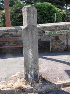
Stone Type: |
Guide Stone |
| |
|
|
|
|
|
|
|
Grid Reference: |
SX/8132/7785 |
| |
|
|
|
|
|
|
|
Location: |
On the pavement, in the fork between Newton Road and Ashburton Road. |
| |
|
|
|
|
|
|
|
Inscription: |
To Newton / To Ashburton |
| |
|
|
|
|
|
|
|
|
|
| |
|
|
|
|
|
|
|
|
|
|
|
|
|
|
|
|
| |
|
|
|
|
|
|
|
|
|
|
|
|
|
|
|
|
|
|
|
|
|
|
|
|
|
|
|
|
|
|
|
|
| |
|
|
|
|
|
|
|
|
|
|
|
|
|
| |
|
|
|
|
|
|
|
|
|
|
|
|
|
|
|
|
|
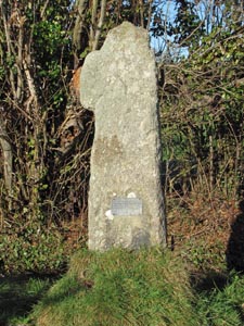
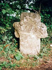
Stone Type: |
Cross |
|
|
|
|
|
|
|
|
|
Grid Reference: |
SX/8100/7785 |
|
|
|
|
|
|
|
|
|
Location: |
On the footpath that runs between the A382 and Challabrook Farm. |
|
|
|
|
|
|
|
|
|
Inscription: |
This old Cross once marked - the grave of a Royalist - Officer who fell near
here - 1645 when Cromwell's Troops - Defeated the Royalists. |
|
|
|
|
|
|
|
|
|
Notes: |
This cross is normally known as: Cavalier Cross. |
|
|
|
|
|
|
|
|
| |
|
|
|
|
|
|
|
|
|
|
|
|
|
|
|
|
| |
|
|
|
|
|
|
|
|
|
|
|
|
|
|
|
|
| |
|
|
|
|
|
|
|
|
|
|
|
|
|
|
| |
|
|
|
|
|
|
|
|
|
|
|
|
|
| |
|
|
|
|
|
|
|
|
|
|
|
|
|
|
|
|
| |
|
|
|
|
|
|
|
Stone Type: |
Milestone |
| |
|
|
|
|
|
|
|
Grid Reference: |
SX/8111/7723 |
| |
|
|
|
|
|
|
|
Location: |
In the lane, to the North West of Pottery Pond. |
| |
|
|
|
|
|
|
|
Notes: |
This Milestone marks the 3 Mile point of the Haytor Granite Railway from its
source at Teigngrace. |
| |
|
|
|
|
|
|
|
|
|
| |
|
|
|
|
|
|
|
|
|
|
|
|
|
|
|
|
| |
|
|
|
|
|
|
|
|
|
|
|
|
|
|
|
|
|
|
|
|
|
|
|
|
|
|
|
|
|
|
|
|
| |
|
|
|
|
|
|
|
|
|
|
|
|
|
| |
|
|
|
|
|
|
|
|
|
|
|
|
|
|
|
|
|
Stone Type: |
Milestone |
|
|
|
|
|
|
|
|
|
Grid Reference: |
SX/7995/7814 |
|
|
|
|
|
|
|
|
|
Location: |
Beside the footpath that runs through the Colehayes Plantation. |
|
|
|
|
|
|
|
|
|
Notes: |
This Milestone marks the 4 Mile point of the Haytor Granite Railway from its
source at Teigngrace. |
|
|
|
|
|
|
|
|
| |
|
|
|
|
|
|
|
|
|
| |
|
|
|
|
|
|
|
|
|
|
|
|
|
|
|
|
| |
|
|
|
|
|
|
|
|
|
|
|
|
|
|
|
|
| |
|
|
|
|
|
|
|
|
|
|
|
|
|
|
| |
|
|
|
|
|
|
|
|
|
|
|
|
|
| |
|
|
|
|
|
|
|
|
|
|
|
|
|
|
|
|
| |
|
|
|
|
|
|
|
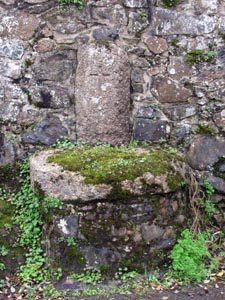
Stone Type: |
Incised Cross |
|
|
|
|
|
|
|
|
Grid Reference: |
SX/8142/7885 |
|
|
|
|
|
|
|
|
Location: |
Built into the wall of Cross Cottage, opposite to the entrance to the
Hospital. |
| |
|
|
|
|
|
|
|
Notes: |
The remains of this cross and its base was moved to this position by Dr
Crocker in 1815, due to a road widening scheme. |
| |
|
|
|
|
|
|
|
|
|
| |
|
|
|
|
|
|
|
|
|
|
|
|
|
|
|
|
|
|
|
|
|
|
|
|
|
|
|
|
|
|
|
|
| |
|
|
|
|
|
|
|
|
|
|
|
|
|
| |
|
|
|
|
|
|
|
|
|
|
|
|
|
|
Stone Type: |
Milestone |
|
|
|
|
|
|
|
|
|
Grid Reference: |
SX/8144/7883 |
|
|
|
|
|
|
|
|
|
Location: |
On the North East side of Mary Street, about 50 metres South of the entrance
to the Hospital. |
|
|
|
|
|
|
|
|
|
Inscription: |
Newton 6 - Moreton 6.2.0 |
|
|
|
|
|
|
|
|
| |
|
|
|
|
|
|
|
|
|
| |
|
|
|
|
|
|
|
|
|
|
| |
|
|
|
|
|
|
|
|
|
|
| |
|
|
|
|
|
|
|
| |
|
|
|
|
|
|
| |
|
|
|
|
|
|
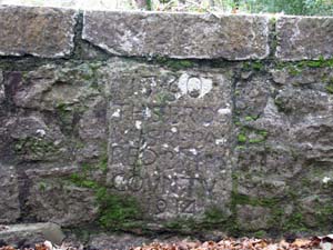
Stone Type: |
Bridge Plaque (Wilford Bridge) |
| |
|
|
|
|
|
|
Grid Reference: |
SX/7985/7972 |
| |
|
|
|
|
|
|
Location: |
Built into the parapet of the Bridge. |
| |
|
|
|
|
|
|
Inscription: |
1730 -
This Bridg Was Repaired by the County 1914 |
| |
|
|
|
|
|
|
|
|
| |
|
|
|
|
|
|
|
|
|
|
|
|
|
|
|
|
|
|
|
|
|
|
|
|
|
|
|
|
|
|
| |
|
|
|
|
|
|
|
|
|
|
|
|
|
|
|
|
| |
|
|
|
|
|
|
|
|
|
|
|
|
|
|
|
|
|
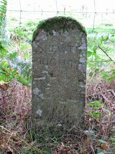
Stone Type: |
Boundary Stone |
|
|
|
|
|
|
|
|
|
Grid Reference: |
SX/7904/7819 |
|
|
|
|
|
|
|
|
|
Location: |
Beside the footpath that runs from Cullender (B3387) to Reddaford Water. |
|
|
|
|
|
|
|
|
|
Inscription: |
Shewte Right |
|
|
|
|
|
|
|
|
|
Notes: |
It is understood that this Stone marks the boundary of the land belonging to
the Shewte Estate. |
|
|
|
|
|
|
|
|
| |
|
|
|
|
|
|
|
|
|
|
|
|
|
|
|
|
| |
|
|
|
|
|
|
|
|
|
|
|
|
|
|
|
|
| |
|
|
|
|
|
|
|
|
|
|
|
|
|
|
| |
|
|
|
|
|
|
|
|
|
|
|
|
|
| |
|
|
|
|
|
|
|
|
|
|
|
|
|
|
|
|
| |
|
|
|
|
|
|
|
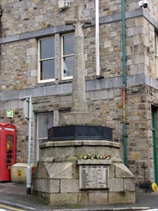
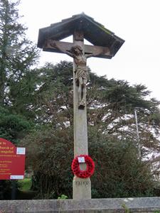
Stone Type: |
Cross |
| |
|
|
|
|
|
|
|
Grid Reference: |
SX/8171/7857 |
| |
|
|
|
|
|
|
|
Location: |
Adjacent to the Town Hall, at the junction Fore street and Mary Street. |
| |
|
|
|
|
|
|
|
Notes: |
This cross serves as the Town's War Memorial. |
| |
|
|
|
|
|
|
|
|
|
| |
|
|
|
|
|
|
|
|
|
|
|
|
|
|
|
|
| |
|
|
|
|
|
|
|
|
|
|
|
|
|
|
|
|
|
|
|
|
|
|
|
|
|
|
|
|
|
|
|
|
|
|
|
|
|
|
|
|
|
|
|
|
|
|
|
|
|
|
|
|
|
|
|
|
|
|
|
|
|
|
|
|
|
|
Stone Type: |
Cross |
|
|
|
|
|
|
|
|
|
Grid Reference: |
SX/8205/7858 |
|
|
|
|
|
|
|
|
|
Location: |
On the green between the church gate and the churchyard. |
|
|
|
|
|
|
|
|
|
Inscription: |
In Memorium - Charles Leslie Courtenay, Priest - 45 Years Vicar of this
Parish - OBIIT OCTOBER 29th 1894 |
|
|
|
|
|
|
|
|
|
|
|
|
|
|
|
|
|
|
|
|
|
|
|
|
|
|
|
|
|
|
|
|
|
|
|
|
|
|
|
|
|
|
|
|
|
|
|
|
|
|
|
|
|
|
|
|
|
|
|
|
|
|
|
|
|
|
|
|
|
|
|
| |
|
|
|
|
|
|
|
|
|
|
|
|
|
| |
|
|
|
|
|
|
|
|
|
|
|
|
|
|
|
|
| |
|
|
|
|
|
|
|
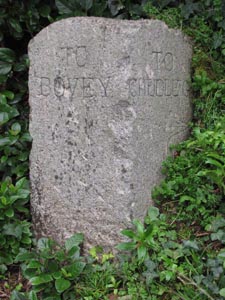
Stone Type: |
Guide Stone |
| |
|
|
|
|
|
|
|
Grid Reference: |
SX/8224/7841 |
| |
|
|
|
|
|
|
|
Location: |
On the bank in the fork of the road at Coombe Cross. |
| |
|
|
|
|
|
|
|
Inscription: |
To Bovey / To Chudleigh |
| |
|
|
|
|
|
|
|
|
|
| |
|
|
|
|
|
|
|
|
|
|
|
|
|
|
|
|
| |
|
|
|
|
|
|
|
|
|
|
|
|
|
|
|
|
|
|
|
|
|
|
|
|
|
|
|
|
|
|
|
|
| |
|
|
|
|
|
|
|
|
|
|
|
|
|
| |
|
|
|
|
|
|
|
|
|
|
|
|
|
|
|
|
|
Stone Type: |
Guide Stone |
|
|
|
|
|
|
|
|
|
Grid Reference: |
SX/8294/7786 |
|
|
|
|
|
|
|
|
|
Location: |
In the fork of the road, at the turn off the B3344 to Little Bovey Farm. |
|
|
|
|
|
|
|
|
|
Inscription: |
To Little Bovey |
|
|
|
|
|
|
|
|
| |
|
|
|
|
|
|
|
|
|
| |
|
|
|
|
|
|
|
|
|
|
|
|
|
|
|
|
| |
|
|
|
|
|
|
|
|
|
|
|
|
|
|
|
|
| |
|
|
|
|
|
|
|
|
|
|
|
|
|
|
| |
|
|
|
|
|
|
|
|
|
|
|
|
|
| |
|
|
|
|
|
|
|
|
|
|
|
|
|
|
|
|
| |
|
|
|
|
|
|
|
Stone Type: |
Guide Stone |
| |
|
|
|
|
|
|
|
Grid Reference: |
SX/8055/7830 |
| |
|
|
|
|
|
|
|
Location: |
Set on the grass verge in the Five Wyches Junction of the B3387 with the
road that leads off to Manaton. |
| |
|
|
|
|
|
|
|
Inscription: |
To Manaton and Lustleigh / To N Bovey / To Widecombe - Haytor. |
| |
|
|
|
|
|
|
|
|
|
| |
|
|
|
|
|
|
|
|
|
|
|
|
|
|
|
|
|
|
|
|
|
|
|
|
|
|
|
|
|
|
|
|
| |
|
|
|
|
|
|
|
|
|
|
|
|
|
| |
|
|
|
|
|
|
|
|
|
|
|
|
|
|
Stone Type: |
Boundary Stone |
|
|
|
|
|
|
|
|
|
Grid Reference: |
SX/8082/7825 |
|
|
|
|
|
|
|
|
|
Location: |
On the grass verge on the north side of the B3387, outside the entrance to
Parke House (DNP Headquarters). |
|
|
|
|
|
|
|
|
|
Inscription: |
Dartmoor National Park |
|
|
|
|
|
|
|
|
| |
|
|
|
|
|
|
|
|
|
| |
|
|
|
|
|
|
|
|
|
|
|
|
|
|
|
|
| |
|
|
|
|
|
|
|
|
|
|
|
|
|
|
|
|
| |
|
|
|
|
|
|
|
|
|
|
|
|
|
| |
|
|
|
|
|
|
|
|
|
|
|
|
| |
|
|
|
|
|
|
Stone Type: |
Marker Stone |
| |
|
|
|
|
|
|
Grid Reference: |
SX/814/782 |
| |
|
|
|
|
|
|
Location: |
Built into the wall of the bridge over the River Bovey in the
centre of Bovey Tracey, between the road and pavement. |
| |
|
|
|
|
|
|
Inscription: |
1 6 4 2 |
| |
|
|
|
|
|
|
Notes: |
This stone is sited to the left of the similar one below. |
|
|
|
|
|
|
|
|
|
|
|
|
|
|
| |
|
|
|
|
|
|
|
|
|
|
|
|
Stone Type: |
Marker Stone |
|
|
|
|
|
|
|
|
Grid Reference: |
SX/814/782 |
|
|
|
|
|
|
|
|
Location: |
Built into the wall of the bridge over the River Bovey in the
centre of Bovey Tracey, between the road and pavement. |
|
|
|
|
|
|
|
|
Inscription: |
1 6 4 2 |
|
|
|
|
|
|
|
|
Notes: |
This stone is sited to the right of the similar one above. |
|
|
|
|
|
|
|
| |
|
|
|
|
|
|
|
|
|
|
|
|
|
| |
|
|
|
|
|
|
|
|
|
|
|
|
| |
|
|
|
|
|
|
|
|
|
|
|
|
|
|
|
|
| |
|
|
|
|
|
|
|
Stone Type: |
Boundary Stone |
| |
|
|
|
|
|
|
|
Grid Reference: |
SX/7988/7817 |
| |
|
|
|
|
|
|
|
Location: |
In the south west corner of the Lower Down road junction on the B3387, west
of Bovey Tracey. |
| |
|
|
|
|
|
|
|
Inscription: |
D N P (Dartmoor National Park) |
| |
|
|
|
|
|
|
|
Notes: |
This
Boundary Stone has now been replaced by a new one on the same site (7
photos below). |
| |
|
|
|
|
|
|
|
|
|
|
|
|
|
|
|
|
| |
|
|
|
|
|
|
|
|
|
|
|
|
|
|
|
|
|
|
|
|
|
|
|
|
|
|
|
|
|
|
|
|
| |
|
|
|
|
|
|
|
|
|
|
|
|
|
| |
|
|
|
|
|
|
|
|
|
|
|
|
|
|
|
|
|
Stone Type: |
Elsford (Waymarker) Cross |
|
|
|
|
|
|
|
|
|
Grid Reference: |
SX/792/829 |
|
|
|
|
|
|
|
|
|
Location: |
At the side of the road, opposite the lane leading down to Lower Elsford
Farm. |
|
|
|
|
|
|
|
|
| |
|
|
|
|
|
|
|
|
|
| |
|
|
|
|
|
|
|
|
|
| |
|
|
|
|
|
|
|
|
|
|
|
|
|
|
|
|
| |
|
|
|
|
|
|
|
|
|
|
|
|
|
|
|
|
| |
|
|
|
|
|
|
|
|
|
|
|
|
|
|
| |
|
|
|
|
|
|
|
|
|
|
|
|
|
| |
|
|
|
|
|
|
|
|
|
|
|
|
|
|
|
|
| |
|
|
|
|
|
|
|
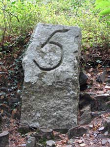
Stone Type: |
Milestone |
| |
|
|
|
|
|
|
|
Grid Reference: |
SX/7856/7848 |
| |
|
|
|
|
|
|
|
Location: |
Set into the bank on the south side of the old rail track inside the eastern
edge of Yarner Wood. |
| |
|
|
|
|
|
|
|
Inscription: |
This Milestone marks the 5 Mile point of the Haytor Granite Railway from its
source at Teigngrace. |
| |
|
|
|
|
|
|
|
|
|
| |
|
|
|
|
|
|
|
|
|
|
|
|
|
|
|
|
| |
|
|
|
|
|
|
|
|
|
|
|
|
|
|
|
|
|
|
|
|
|
|
|
|
|
|
|
|
|
|
|
|
| |
|
|
|
|
|
|
|
|
|
|
|
|
|
| |
|
|
|
|
|
|
|
|
|
|
|
Stone Type: |
Milestone |
|
|
|
|
|
|
|
|
|
Grid Reference: |
SX/7806/7738 |
|
|
|
|
|
|
|
|
|
Location: |
Set back from the road on the north side of the B3387, almost opposite the
junction with Green Lane. |
|
|
|
|
|
|
|
|
|
Inscription: |
This Milestone marks the 6 Mile point of the Haytor Granite Railway from its
source at Teigngrace. |
|
|
|
|
|
|
|
|
| |
|
|
|
|
|
|
|
|
|
| |
|
|
|
|
|
|
|
|
|
|
|
|
|
|
|
|
| |
|
|
|
|
|
|
|
|
|
|
|
|
|
|
|
|
| |
|
|
|
|
|
|
|
|
|
|
|
|
|
|
| |
|
|
|
|
|
|
|
|
|
|
|
|
|
| |
|
|
|
|
|
|
|
|
|
|
|
|
|
|
|
|
| |
|
|
|
|
|
|
|
Stone Type: |
Guide Stone |
| |
|
|
|
|
|
|
|
Grid Reference: |
SX/7883/7897 |
| |
|
|
|
|
|
|
|
Location: |
Reddaford Water Cross, north east corner of the junction of the road to
Lustleigh with the Bovey Tracey - Manaton road. |
| |
|
|
|
|
|
|
|
Inscription: |
To Lustleigh / To Manaton / To Bovey |
| |
|
|
|
|
|
|
|
|
|
| |
|
|
|
|
|
|
|
|
|
|
|
|
|
|
|
|
| |
|
|
|
|
|
|
|
|
|
|
|
|
|
|
|
|
|
|
|
|
|
|
|
|
|
|
|
|
|
|
|
| |
|
|
|
|
|
|
|
|
|
|
|
|
|
Stone Type: |
Boundary Stone |
|
|
|
|
|
|
|
|
Grid Reference: |
SX/8059/7855 |
|
|
|
|
|
|
|
|
Location: |
To the left-hand side of the entrance porch to Parke House. |
|
|
|
|
|
|
|
|
Inscription: |
S D R (South Devon Railway) |
|
|
|
|
|
|
|
|
Notes: |
This stone was rescued from the Moretonhampstead to Bovey Tracey Line when
it was closed down. |
|
|
|
|
|
|
|
| |
|
|
|
|
|
|
|
|
|
|
|
|
| |
|
|
|
|
|
|
|
|
|
|
|
| |
|
|
|
|
|
|
Stone Type: |
Boundary Stone |
| |
|
|
|
|
|
|
Grid Reference: |
SX/8060/7856 |
| |
|
|
|
|
|
|
Location: |
To the right-hand side of the entrance porch to Parke House. |
| |
|
|
|
|
|
|
Inscription: |
S D R (South Devon Railway) |
| |
|
|
|
|
|
|
Notes: |
This stone was rescued from the Moretonhampstead to Bovey Tracey Line when
it was closed down. |
|
|
|
|
|
|
|
|
|
|
|
|
|
|
|
| |
|
|
|
|
|
|
|
|
|
|
|
|
| |
|
|
|
|
|
|
|
|
|
|
|
|
|
|
|
|
|
Stone Type: |
Marker Stone |
|
|
|
|
|
|
|
|
|
Grid Reference: |
SX/8059/7856 |
|
|
|
|
|
|
|
|
|
Location: |
Set in the garden border a few yards to the left-hand side of the entrance
porch to Parke House (Dartmoor National Park HQ). |
|
|
|
|
|
|
|
|
|
Inscription: |
D N P 4 0 |
|
|
|
|
|
|
|
|
|
Notes: |
Commemorates 40 years since the National Park became an elected body. |
|
|
|
|
|
|
|
|
| |
|
|
|
|
|
|
|
|
|
|
|
|
|
|
|
|
| |
|
|
|
|
|
|
|
|
|
|
|
|
|
|
|
|
| |
|
|
|
|
|
|
|
|
|
|
|
|
|
|
| |
|
|
|
|
|
|
|
|
|
|
|
|
|
| |
|
|
|
|
|
|
|
|
|
|
|
|
|
|
|
|
| |
|
|
|
|
|
|
|
Stone Type: |
Boundary Stone |
| |
|
|
|
|
|
|
|
Grid Reference: |
SX/7990/8122 |
| |
|
|
|
|
|
|
|
Location: |
On the grass verge on the western side of the A382 at Slade Cross. |
| |
|
|
|
|
|
|
|
Inscription: |
B / L (Bovey / Lustleigh) |
| |
|
|
|
|
|
|
|
|
|
| |
|
|
|
|
|
|
|
|
|
|
|
|
|
|
|
|
|
|
|
|
|
|
|
|
|
|
|
|
|
|
|
|
|
|
|
|
|
|
|
|
|
|
|
|
|
|
|
|
|
|
|
|
|
|
|
|
|
|
|
|
|
|
|
|
|
|
|
|
|
|
|
|
|
|
|
|
|
|
|
|
|
Stone Type: |
Boundary
Stone |
|
|
|
|
|
|
|
|
|
Grid Reference: |
SX/7805/7739 |
|
|
|
|
|
|
|
|
|
Location: |
On
the edge of Haytor Down, close to the B3387. |
|
|
|
|
|
|
|
|
|
Inscription: |
P
B (Perryman's Bridge) |
|
|
|
|
|
|
|
|
|
Notes: |
The
stone marks the boundary of the Bovey Tracey Parish. |
|
|
|
|
|
|
|
|
|
|
|
|
|
|
|
|
|
|
|
|
|
|
|
|
|
|
|
|
|
|
|
|
|
|
|
|
|
|
|
|
|
|
|
|
|
|
|
|
|
|
|
|
|
|
|
|
|
|
|
|
|
|
|
|
|
|
|
|
|
|
|
|
|
|
|
|
Stone Type: |
Boundary
Stone |
|
|
|
|
|
|
|
Grid Reference: |
SX/7915/7884 |
|
|
|
|
|
|
|
Location: |
On
the southern verge of the road that runs between Bovey Tracey and Manaton,
just below the Haytor Junction. |
|
|
|
|
|
|
|
|
| |
|
|
|
|
|
|
Inscription: |
Dartmoor
National Park |
|
|
|
|
|
|
|
|
|
|
|
|
|
|
|
|
|
|
|
|
|
|
|
|
|
|
|
Stone Type: |
Civil
War Marker Stone |
|
|
|
|
|
|
|
|
Grid Reference: |
SX/8176/7859 |
|
|
|
|
|
|
|
|
Location: |
Set
into the wall of a house in East Street. |
|
|
|
|
|
|
|
|
Inscription: |
1654
/ TDED |
|
|
|
|
|
|
|
|
|
|
|
|
|
|
|
|
|
|
|
|
|
|
|
|
|
|
|
|
|
|
|
|
|
|
|
|
|
|
|
|
|
|
|
|
|
|
|
|
|
|
|
|
|
|
|
|
|
|
|
|
|
|
|
|
|
|
|
|
Stone Type: |
Great
War Marker Stone |
|
|
|
|
|
|
|
|
Grid Reference: |
SX/8269/7799 |
|
|
|
|
|
|
|
|
Location: |
At
the junction of Centenary Way and Mountford Drive. |
|
|
|
|
|
|
|
|
Notes: |
The
plaque states that the road names on this estate have been named after
local casualties of the Great War. |
|
|
|
|
|
|
|
|
|
|
|
|
|
|
|
|
|
|
|
|
|
|
|
|
|
|
|
|
|
|
|
|
|
|
|
|
|
|
|
|
|
|
|
|
|
|
|
|
|
|
|
|
|
|
|
|
|
|
|
|
|
|
|
|
|
|
|
|
|
|
|
|
|
|
|
|
|
|
|
|
|
|
|
|
|
|
|
|
|
|
|
|
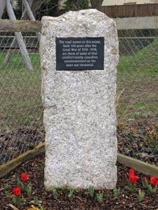
Stone Type: |
Marker
Stone |
|
|
|
|
|
|
|
|
|
Grid Reference: |
SX/8130/7841 |
|
|
|
|
|
|
|
|
|
Location: |
On
the grass in Mill Marsh Park, Bovey Tracey |
|
|
|
|
|
|
|
|
|
Inscription: |
Jesus
Light of the World / To Mark 2000 Years since the Birth of Jesus Christ |
|
|
|
|
|
|
|
|
|
|
|
|
|
|
|
|
|
|
|
|
|
|
|
|
|
|
|
|
|
|
|
|
|
|
|
|
|
|
|
|
|
|
|
|
|
|
|
|
|
|
|
|
|
|
|
|
|
|
|
|
|
|
|
|
|
|
|
|
|
|
|
|
|
|
|
|
|
|
|
|
|
|
|
|
|
|
|
|
|
|
|
|
|
|
|
|
|
|
|
|
|
|
|
|
|
Stone Type: |
Boundary
Stone |
|
|
|
|
|
|
|
|
Grid Reference: |
SX/7988/7817 |
|
|
|
|
|
|
|
|
Location: |
In the south west corner of the Lower Down road junction on the B3387, west
of Bovey Tracey. |
|
|
|
|
|
|
|
|
Inscription: |
D N P (Dartmoor National Park) |
|
|
|
|
|
|
|
|
Notes: |
This
modern Boundary Stone has replaced the one previously on the same site (7
photos above). |
|
|
|
|
|
|
|
|
|
|
|
|
|
|
|
|
|
|
|
|
|
|
|
|
|
|
|
|
|
|
|
|
|
|
|
|
|
|
|
|
|
|
|
|
|
|
|
|
|
|
|
|
|
|
|
|
|
|
|
|
|
|
|
|
|
|
|
|
|
|
|
|
|
|
|
|
|
|
|
|
|
|
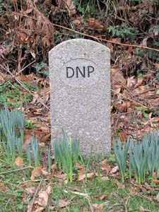
Stone Type: |
Boundary
Stone |
|
|
|
|
|
|
|
|
|
Grid Reference: |
SX/8045/8000 |
|
|
|
|
|
|
|
|
|
Location: |
On
the western verge of the A382 at Kings Cross. |
|
|
|
|
|
|
|
|
|
Inscription: |
D N P (Dartmoor National Park) |
|
|
|
|
|
|
|
|
|
|
|
|
|
|
|
|
|
|
|
|
|
|
|
|
|
|
|
|
|
|
|
|
|
|
|
|
|
|
|
|
|
|
|
|
|
|
|
|
|
|
|
|
|
|
|
|
|
|
|
|
|
|
|
|
|
|
|
|
|
|
|
|
|
|
|
|
|
|
|
|
|
|
|
|
|
|
|
|
|
Stone Type: |
Milestone |
|
|
|
|
|
|
|
|
Grid Reference: |
SX/8044/8002 |
|
|
|
|
|
|
|
|
Location: |
Set
back against the hedge on the side road leading off the A382 at Kings
Cross. |
|
|
|
|
|
|
|
|
Inscription: |
Newton
(Abbot) 7. / Bovey (Tracey) 1. 2. 0. / Moreton (Moretonhampstead) 6. 2. 0. |
|
|
|
|
|
|
|
|
Notes: |
The
distances are shown in Miles, Furlongs and Poles. |
|
|
|
|
|
|
|
|
|
|
|
|
|
|
|
|
|
|
|
|
|
|
|
|
|
|
|
|
|
|
|
|
|
|
|
|
|
|
|
|
|
|
|
|
|
|
|
|
|
|
|
|
|
|
|
|
|
|
|
|
|
|
|
|
|
|
|
|
|
|
|
|
|
|
|
|
|
|
|
|
|
|
|
|
|
|
|
|
|
|
|
|
|
|
|
|
|
|
|
|
|
|
|
|
|
|
|
|
|
|
|
|
|
|
|
|
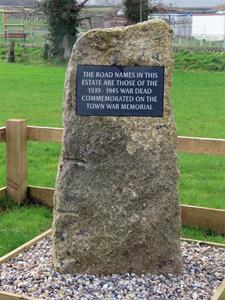
Stone Type: |
Marker
Stone |
|
|
|
|
|
|
|
|
|
Grid Reference: |
SX/8100/7781 |
|
|
|
|
|
|
|
|
|
Location: |
At
the Junction of Marriott Way, Bovey Tracey |
|
|
|
|
|
|
|
|
|
Inscription: |
The
road names in this estate are those of the 1939 - 1945 war dead
commemorated on the town war memorial. |
|
|
|
|
|
|
|
|
|
|
|
|
|
|
|
|
|
|
|
|
|
|
|
|
|
|
|
|
|
|
|
|
|
|
|
|
|
|
|
|
|
|
|
|
|
|
|
|
|
|
|
|
|
|
|
|
|
|
|
|
|
|
|
|
|
|
|
|
|
|
|
|
|
|
|
|
|
|
|
|
|
|
|
|
|
|
|
|
|
|
|
|
|
|
|
|
|
|
|
|
|
|
|
|
|
Stone Type: |
Crucifixion
Cross |
|
|
|
|
|
|
|
|
Grid Reference: |
SX/8129/7777 |
|
|
|
|
|
|
|
|
Location: |
In
the Ashburton Road Churchyard, Bovey Tracey |
|
|
|
|
|
|
|
|
|
|
|
|
|
|
|
|
|
|
|
|
|
|
|
|
|
|
|
|
|
|
|
|
|
|
|
|
|
|
|
|
|
|
|
|
|
|
|
|
|
|
|
|
|
|
|
|
|
|
|
|
|
|
|
|
|
|
|
|
|
|
|
|
|
|
|
|
|
|
|
|
|
|
|
|
|
|
|
|
|
|
|
|
|
|
|
|
|
|
|
|
|
|
Stone Type: |
War
Memorial Cross |
|
|
|
|
|
|
|
|
|
Grid Reference: |
SX/8132/7784 |
|
|
|
|
|
|
|
|
|
Location: |
In
the Ashburton Road Churchyard, Bovey Tracey |
|
|
|
|
|
|
|
|
|
Inscription: |
1914-1918 |
|
|
|
|
|
|
|
|
|
|
|
|
|
|
|
|
|
|
|
|
|
|
|
|
|
|
|
|
|
|
|
|
|
|
|
|
|
|
|
|
|
|
|
|
|
|
|
|
|
|
|
|
|
|
|
|
|
|
|
|
|
|
|
|
|
|
|
|
|
|
|
|
|
|
|
|
|
|
|
|
|
|
|
|
|
|
|
|
|
| |
|
|
|
|
|
|
|
|
|
|
|
|
|
|
|
|
|
|
|
|
|
|
|
|
|
|
|
|
|
|
|
|
|
|
|
|
|
|
|