|
Devon Marker Stones |

![]()
|
|||||||||||||||||||||
 |
 |
 |
 |
 |
 |
 |
 |
|
||||||||||||||||||||||||||||||||||||||||||
| District: | Teignbridge |
|
||||||||||||||||||||||||||||||||||||||||
| Parish: | Bridford |
|
||||||||||||||||||||||||||||||||||||||||
|
|
|||||||||||||||||||||||||||||||||||||||||
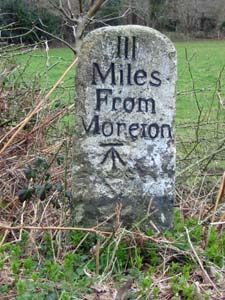
| Stone Type: | Milestone | |||||||||||||||||||||||||||||||||||||||||
| Grid Reference: | SX/7874/8742 | |||||||||||||||||||||||||||||||||||||||||
| Location: | At the side of the B3212, about 1¼ kilometres to the north east of Doccombe. | |||||||||||||||||||||||||||||||||||||||||
| Inscription: | III Miles From Moreton (3 Miles from Moretonhampstead). | |||||||||||||||||||||||||||||||||||||||||
| Notes: | The stone also has an Ordnance Survey Benchmark on its face. | |||||||||||||||||||||||||||||||||||||||||
|
||||||||||||||||||||||||||||||||||||||||||
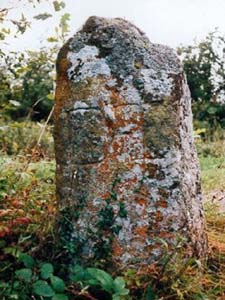
| Stone Type: | Waymarker Stone | |||||||||||||||||||||||||||||||||||||||||
| Grid Reference: | SX/7419/8880 | |||||||||||||||||||||||||||||||||||||||||
| Location: | On a triangle of grass, at the junction of the road from Uppacott Farm to Willingstone, where the path leads in to Cranbrook Castle. | |||||||||||||||||||||||||||||||||||||||||
| Inscription: | D T / E / M / C (Drewsteignton / Exeter / Moretonhampstead / Chagford). | |||||||||||||||||||||||||||||||||||||||||
|
||||||||||||||||||||||||||||||||||||||||||
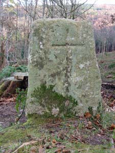
| Stone Type: | Waymarker Cross | |||||||||||||||||||||||||||||||||||||||||
| Grid Reference: | SX/7425/8954 | |||||||||||||||||||||||||||||||||||||||||
| Location: | On the eastern side of the footpath from Fingle Bridge to Cranbrook Castle. | |||||||||||||||||||||||||||||||||||||||||
| Notes: | The cross also has an Ordnance Survey Benchmark on one of its edges. | |||||||||||||||||||||||||||||||||||||||||
|
||||||||||||||||||||||||||||||||||||||||||
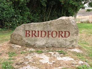
| Stone Type: | Bridford Village Stone | |||||||||||||||||||||||||||||||||||||||||
| Grid Reference: | SX/8191/8642 | |||||||||||||||||||||||||||||||||||||||||
| Location: | On the approach to the village from the east. | |||||||||||||||||||||||||||||||||||||||||
| Inscription: | BRIDFORD | |||||||||||||||||||||||||||||||||||||||||
|
||||||||||||||||||||||||||||||||||||||||||
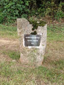
| Stone Type: | Queen Elizabeth II Jubilee Stone | |||||||||||||||||||||||||||||||||||||||||
| Grid Reference: | SX/8192/8642 | |||||||||||||||||||||||||||||||||||||||||
| Location: | On the approach to the village from the east (near the Bridford Village Stone, above). | |||||||||||||||||||||||||||||||||||||||||
| Inscription: | Queen Elizabeth II Silver Jubilee 1977 | |||||||||||||||||||||||||||||||||||||||||
|
||||||||||||||||||||||||||||||||||||||||||
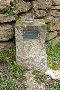
| Stone Type: | Boundary Stone | |||||||||||||||||||||||||||||||||||||||||
| Grid Reference: | SX/8048/8831 | |||||||||||||||||||||||||||||||||||||||||
| Location: | Built into the north west parapet of Steps Bridge, slightly to the south west of centre. | |||||||||||||||||||||||||||||||||||||||||
| Inscription: | BRIDFORD | |||||||||||||||||||||||||||||||||||||||||
|
||||||||||||||||||||||||||||||||||||||||||
| Stone Type: | Marker Stone | |||||||||||||||||||||||||||||||||||||||||
| Grid Reference: | SX/81196/86515 | |||||||||||||||||||||||||||||||||||||||||
| Location: | Back against the wall at the entrance to the farm. | |||||||||||||||||||||||||||||||||||||||||
| Inscription: | Ordnance Survey B M (Bench Mark) | |||||||||||||||||||||||||||||||||||||||||
|
||||||||||||||||||||||||||||||||||||||||||
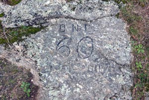
| Stone Type: | Marker Stone | |||||||||||||||||||||||||||||||||||||||||
| Grid Reference: | SX/78665/85586 | |||||||||||||||||||||||||||||||||||||||||
| Location: | At the foot of Blackingstone Rock, Bridford | |||||||||||||||||||||||||||||||||||||||||
| Inscription: | DNP / 60 / 1951 - 2011 | |||||||||||||||||||||||||||||||||||||||||
| Notes | The stone marks the 60th Anniversary of the formation of the Dartmoor National Park | |||||||||||||||||||||||||||||||||||||||||