| |
|
|
|
|
|
|
|
|
|
|
|
|
| |
|
|
|
|
|
|
|
|
|
|
|
|
|
|
|
|
|
|
|
|
District: |
Teignbridge |
|
|
|
|
|
|
|
|
|
|
|
 |
|
| |
|
|
|
|
|
|
|
|
|
|
|
|
|
|
|
|
|
|
Parish: |
Buckfastleigh |
 |
 |
 |
|
|
|
|
| |
|
|
|
|
|
|
|
|
|
|
|
|
|
|
|
|
|
|
|
| |
|
|
|
|
|
|
|
|
|
|
|
|
|
|
|
|
|
|
|
| |
|
|
|
|
|
|
|
|
|
|
|
|
|
|
|
|
|
|
|
| Page
Contents: |
|
| |
5 Boundary Stones |
| |
4 Crosses |
| |
1 Guide Stone |
| |
3 Marker Stones |
| |
2 Milestones |
| |
|
|
|
|
|
|
|
|
|
|
|
|
|
|
|
|
|
|
| |
|
|
|
|
|
|
|
|
|
|
|
|
|
| |
|
|
|
|
|
|
|
|
|
|
|
|
|
| |
|
|
|
|
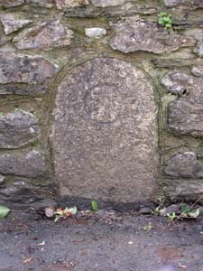
Stone Type: |
Boundary Stone |
| |
|
|
|
|
Grid Reference: |
SX/7427/6615 |
| |
|
|
|
|
Location: |
Built into the wall on the south side of Station Road, about 20 metres from
the junction with Dart Bridge Road. |
| |
|
|
|
|
Inscription: |
C - (County Bridge Stone - see note on Home Page) |
| |
|
|
|
|
|
|
|
|
|
| |
|
|
|
|
|
|
|
|
|
|
|
|
|
|
|
|
| |
|
|
|
|
|
|
|
|
|
|
|
|
|
|
|
|
| |
|
|
|
|
|
|
|
|
|
|
|
|
|
|
|
|
|
|
|
|
|
|
|
|
|
|
|
|
|
|
|
|
| |
|
|
|
|
|
|
|
|
|
|
|
|
|
|
|
|
| |
|
|
|
|
|
|
|
|
|
|
|
|
|
|
|
|
|
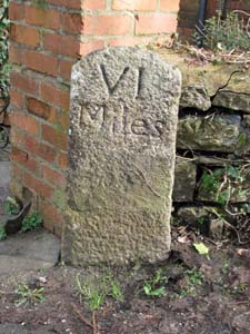
Stone Type: |
Milestone |
|
|
|
|
|
|
|
|
|
Grid Reference: |
SX/7475/6597 |
|
|
|
|
|
|
|
|
|
Location: |
Against the garden wall of No.10 Old Totnes Road. |
|
|
|
|
|
|
|
|
|
Inscription: |
VI Miles (6 Miles to Totnes) |
|
|
|
|
|
|
|
|
| |
|
|
|
|
|
|
|
|
|
| |
|
|
|
|
|
|
|
|
|
|
|
|
|
|
|
|
| |
|
|
|
|
|
|
|
|
|
|
|
|
|
|
|
|
| |
|
|
|
|
|
|
|
|
|
|
|
|
|
| |
|
|
|
|
|
|
|
|
|
|
|
|
| |
|
|
|
|
|
|
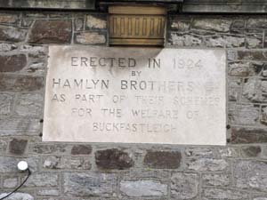
Stone Type: |
Building Marker Plaque
|
| |
|
|
|
|
|
|
Grid Reference: |
SX/7379/6606 |
| |
|
|
|
|
|
|
Location: |
Built into the wall of the Town Hall in Bossell Road. |
| |
|
|
|
|
|
|
Inscription: |
Erected in 1924 by Hamlyn Brothers Ltd as part of their Schemes for the
Welfare of Buckfastleigh. |
| |
|
|
|
|
|
|
|
|
|
|
|
|
|
|
|
|
|
|
|
|
|
|
|
| |
|
|
|
|
|
|
|
|
|
|
|
|
| |
|
|
|
|
|
|
|
|
|
|
|
|
|
|
|
|
|
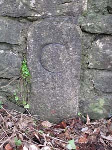
Stone Type: |
Boundary Stone |
|
|
|
|
|
|
|
|
|
Grid Reference: |
SX/7443/6661 |
|
|
|
|
|
|
|
|
|
Location: |
Built into the wall on the south west side of Dart Bridge Road near the Bus
Stop. |
|
|
|
|
|
|
|
|
|
Inscription: |
C - (County Bridge Stone - see note on Home Page) |
|
|
|
|
|
|
|
|
| |
|
|
|
|
|
|
|
|
|
| |
|
|
|
|
|
|
|
|
|
|
|
|
|
|
|
|
| |
|
|
|
|
|
|
|
|
|
|
|
|
|
|
|
|
| |
|
|
|
|
|
|
|
|
|
|
|
|
|
| |
|
|
|
|
|
|
|
|
|
|
|
|
| |
|
|
|
|
|
|
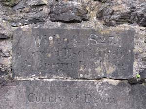
Stone Type: |
Bridge Marker Stone |
| |
|
|
|
|
|
|
Grid Reference: |
SX/7446/6672 |
| |
|
|
|
|
|
|
Location: |
Built into the south eastern parapet of Dart Bridge, immediately above the
stone below. |
| |
|
|
|
|
|
|
Inscription: |
Widened 1827 |
| |
|
|
|
|
|
|
|
|
|
|
|
|
|
|
|
|
|
|
|
|
|
|
| |
|
|
|
|
|
|
|
|
|
|
|
|
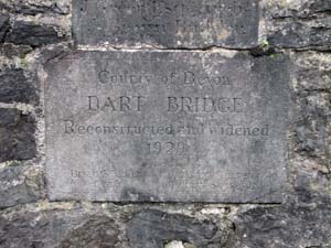
Stone Type: |
Bridge Marker Stone |
|
|
|
|
|
|
|
|
Grid Reference: |
SX/7446/6672 |
|
|
|
|
|
|
|
|
Location: |
Built into the south eastern parapet of Dart Bridge, immediately below the
stone above. |
|
|
|
|
|
|
|
|
Inscription: |
County of Devon / Dart Bridge / Reconstructed and Widened 1929. |
|
|
|
|
|
|
|
| |
|
|
|
|
|
|
|
|
| |
|
|
|
|
|
|
|
|
|
|
|
|
|
| |
|
|
|
|
|
|
|
|
|
|
|
|
| |
|
|
|
|
|
|
|
|
|
|
|
|
|
|
|
|
| |
|
|
|
|
|
|
|
Stone Type: |
Milestone |
| |
|
|
|
|
|
|
|
Grid Reference: |
SX/7456/6718 |
| |
|
|
|
|
|
|
|
Location: |
At the back of the lay-by on the eastern side of the old A38, about 150
metres north of the Furzeleigh Mill Hotel. |
| |
|
|
|
|
|
|
|
Inscription: |
Ashburton II Miles (Ashburton 2 Miles). |
| |
|
|
|
|
|
|
|
|
|
| |
|
|
|
|
|
|
|
|
|
|
|
|
|
|
|
|
| |
|
|
|
|
|
|
|
|
|
|
|
|
|
|
|
|
|
|
|
|
|
|
|
|
|
|
|
|
|
|
|
|
| |
|
|
|
|
|
|
|
|
|
|
|
|
|
| |
|
|
|
|
|
|
|
|
|
|
|
|
|
|
|
|
|
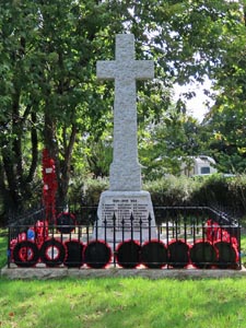
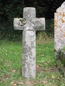
Stone Type: |
Buckfastleigh Memorial Cross |
|
|
|
|
|
|
|
|
|
Grid Reference: |
SX/7421/6652 |
|
|
|
|
|
|
|
|
|
Location: |
Buckfastleigh Churchyard |
|
|
|
|
|
|
|
|
|
Notes: |
The cross serves as a war memorial. The church was destroyed by fire in 1992
and has not been rebuilt. |
|
|
|
|
|
|
|
|
| |
|
|
|
|
|
|
|
|
|
| |
|
|
|
|
|
|
|
|
|
|
|
|
|
|
|
|
| |
|
|
|
|
|
|
|
|
|
|
|
|
|
|
|
|
| |
|
|
|
|
|
|
|
|
|
|
|
|
|
|
| |
|
|
|
|
|
|
|
|
|
|
|
|
|
| |
|
|
|
|
|
|
|
|
|
|
|
|
|
|
|
|
| |
|
|
|
|
|
|
|
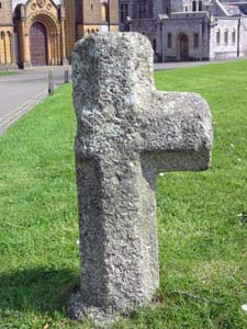
Stone Type: |
Buckfast Abbey (Moorshop) Cross |
| |
|
|
|
|
|
|
|
Grid Reference: |
SX/7407/6741 |
| |
|
|
|
|
|
|
|
Location: |
On the grass within the grounds of Buckfast Abbey. |
| |
|
|
|
|
|
|
|
Notes: |
This was once a waymarker on the ancient route from North Devon, through
Okehampton, to Plympton and Plymouth. |
| |
|
|
|
|
|
|
|
|
|
| |
|
|
|
|
|
|
|
|
|
|
|
|
|
|
|
|
| |
|
|
|
|
|
|
|
|
|
|
|
|
|
|
|
|
|
|
|
|
|
|
|
|
|
|
|
|
|
|
|
|
| |
|
|
|
|
|
|
|
|
|
|
|
|
|
| |
|
|
|
|
|
|
|
|
|
|
|
|
|
|
|
|
|
Stone Type: |
Buckfast Abbey (Great Palston Farm) Cross |
|
|
|
|
|
|
|
|
|
Grid Reference: |
SX/7408/6742 |
|
|
|
|
|
|
|
|
|
Location: |
On the grass within the grounds of Buckfast Abbey. |
|
|
|
|
|
|
|
|
|
Notes: |
It is thought that this cross was once situated nearby as a waymarker stone. |
|
|
|
|
|
|
|
|
| |
|
|
|
|
|
|
|
|
|
| |
|
|
|
|
|
|
|
|
|
|
|
|
|
|
|
|
| |
|
|
|
|
|
|
|
|
|
|
|
|
|
|
|
|
| |
|
|
|
|
|
|
|
|
|
|
|
|
|
|
| |
|
|
|
|
|
|
|
|
|
|
|
|
|
|
|
|
|
|
|
|
|
|
|
|
|
|
|
|
|
|
|
|
|
|
|
|
|
|
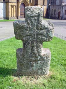
Stone Type: |
Buckfastleigh Churchyard Cross |
|
|
|
|
|
|
|
|
Grid Reference: |
SX/7428/6659 |
|
|
|
|
|
|
|
|
Location: |
Between
two graves in the north-east corner of Buckfastleigh Churchyard. |
|
|
|
|
|
|
|
|
Notes: |
This was probably once a waymarker that has been brought into the churchyard
for safekeeping. |
|
|
|
|
|
|
|
|
|
|
|
|
|
|
|
|
|
|
|
|
|
|
|
|
|
|
|
|
|
|
|
|
|
|
|
|
|
|
|
|
|
|
|
|
|
|
|
|
|
|
|
|
|
|
|
|
|
|
|
|
|
|
|
|
|
|
|
|
|
|
|
|
|
|
|
|
|
|
|
|
|
|
|
|
|
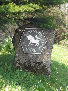
Stone Type: |
Boundary
Stone |
|
|
|
|
|
|
|
|
|
Grid Reference: |
SX/7440/6671 |
|
|
|
|
|
|
|
|
|
Location: |
On
the southern verge of Buckfast Road, Buckfastleigh. |
|
|
|
|
|
|
|
|
|
Inscription: |
Dartmoor
National Park |
|
|
|
|
|
|
|
|
|
|
|
|
|
|
|
|
|
|
|
|
|
|
|
|
|
|
|
|
|
|
|
|
|
|
|
|
|
|
|
|
|
|
|
|
|
|
|
|
|
|
|
|
|
|
|
|
|
|
|
|
|
|
|
|
|
|
|
|
|
|
|
|
|
|
|
|
|
|
|
|
|
|
|
|
|
|
|
|
|
|
|
|
|
|
|
|
|
|
|
|
|
|
|
|
|
|
Stone Type: |
Guide
Stone |
|
|
|
|
|
|
|
|
Grid Reference: |
SX/6990/6679 |
|
|
|
|
|
|
|
|
Location: |
On
the grass verge at the Cross Furzes road junction. |
|
|
|
|
|
|
|
|
Inscription: |
B
(Buckfastleigh) / T (Tavistock / A (Ashburton) |
|
|
|
|
|
|
|
|
|
|
|
|
|
|
|
|
|
|
|
|
|
|
|
|
|
|
|
|
|
|
|
|
|
|
|
|
|
|
|
|
|
|
|
|
|
|
|
|
|
|
|
|
|
|
|
|
|
|
|
|
|
|
|
|
|
|
|
|
|
|
|
|
|
|
|
|
|
|
|
|
|
|
|
|
|
|
|
|
|
|
|
|
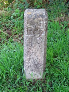
Stone Type: |
Boundary
Stone |
|
|
|
|
|
|
|
|
|
Grid Reference: |
SX/7457/6627 |
|
|
|
|
|
|
|
|
|
Location: |
On
the southern verge of the approach road to Buckfastleigh Train Station. |
|
|
|
|
|
|
|
|
|
Inscription: |
Bdy
(Boundary - for the South Devon Railway) |
|
|
|
|
|
|
|
|
|
|
|
|
|
|
|
|
|
|
|
|
|
|
|
|
|
|
|
|
|
|
|
|
|
|
|
|
|
|
|
|
|
|
|
|
|
|
|
|
|
|
|
|
|
|
|
|
|
|
|
|
|
|
|
|
|
|
|
|
|
|
|
|
|
|
|
|
|
|
|
|
|
|
|
|
|
|
|
|
|
|
|
|
|
|
|
|
|
|
|
|
|
|
|
|
|
|
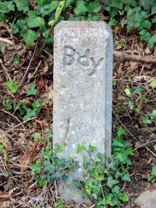
Stone Type: |
Boundary
Stone |
|
|
|
|
|
|
|
|
Grid Reference: |
SX/7453/6625 |
|
|
|
|
|
|
|
|
Location: |
On
the northern verge of the approach road to Buckfastleigh Train Station. |
|
|
|
|
|
|
|
|
Inscription: |
Bdy
(Boundary - for the South Devon Railway) |
|
|
|
|
|
|
|
|
|
|
|
|
|
|
|
|
|
|
|
|
|
|
|
|
|
|
|
|
|
|
|
|
|
|
|
|
|
|
|
|
|
|
|
|
|
|
|
|
|
|
|
|
|
|
|
|
|
|
|
|
|
|
|
|
|
|
|
|
|
|
|
|
|
|
|
|
|
|
|
|
|
|
|
|
|
|
|
|
|
|
|
|
|
|
|
|
|
|
| |
|
|
|
|
|
|
|
|
|
|
|
|
|
|
|
|
|
|
|
|
|
|
|
|
|
|
|
|
|
|
|
|
|
|
|
|
|
|
|