|
Devon Marker Stones |

|
|||||||||||||||||||||
 |
 |
 |
 |
 |
 |
|
||||||||||||||||||||||||||||||||||||||||||
| District: | Teignmouth |
|
||||||||||||||||||||||||||||||||||||||||
| Parish: | Haccombe with Combe | |||||||||||||||||||||||||||||||||||||||||
|
|
|||||||||||||||||||||||||||||||||||||||||
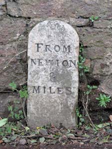
| Stone Type: | Milestone | |||||||||||||||||||||||||||||||||||||||||
| Grid Reference: | SX/9009/7165 | |||||||||||||||||||||||||||||||||||||||||
| Location: | Set against the roadside wall opposite Dodbrook Cottages in Combeinteignhead. | |||||||||||||||||||||||||||||||||||||||||
| Inscription: | From Newton 3 Miles | |||||||||||||||||||||||||||||||||||||||||
|
||||||||||||||||||||||||||||||||||||||||||
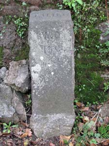
| Stone Type: | Guide Stone | |||||||||||||||||||||||||||||||||||||||||
| Grid Reference: | SX/9012/7161 | |||||||||||||||||||||||||||||||||||||||||
| Location: | Set against the roadside wall near the bend in the centre of Combeinteignhead and about 1 metre from the 'SV' Stone. | |||||||||||||||||||||||||||||||||||||||||
| Inscription: | T U D C / W O 19 | |||||||||||||||||||||||||||||||||||||||||
| Notes: | The TUDC stands for Teignmouth Urban District Council. It's possible that the WO 19 indicates a Water Outlet 19 feet away. | |||||||||||||||||||||||||||||||||||||||||
|
||||||||||||||||||||||||||||||||||||||||||
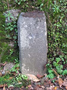
| Stone Type: | Guide Stone | |||||||||||||||||||||||||||||||||||||||||
| Grid Reference: | SX/9012/7161 | |||||||||||||||||||||||||||||||||||||||||
| Location: | Set against the roadside wall near the bend in the centre of Combeinteignhead and about 1 metre from the 'WO' Stone. | |||||||||||||||||||||||||||||||||||||||||
| Inscription: | T U D C / S V 16Ft 8ins | |||||||||||||||||||||||||||||||||||||||||
| Notes: | The TUDC stands for Teignmouth Urban District Council. The SV 16Ft 8ins indicates the presence of a Safety Valve that distance away. | |||||||||||||||||||||||||||||||||||||||||
|
||||||||||||||||||||||||||||||||||||||||||
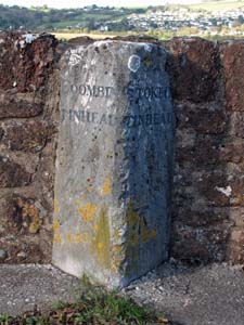
| Stone Type: | Boundary Stone | |||||||||||||||||||||||||||||||||||||||||
| Grid Reference: | SX/9095/7205 | |||||||||||||||||||||||||||||||||||||||||
| Location: | Set against the northern parapet of the bridge over the Arch Brook. | |||||||||||||||||||||||||||||||||||||||||
| Inscription: | Coombintinhead / Stokeintinhead | |||||||||||||||||||||||||||||||||||||||||
| Notes: | The stone also has an Ordnance Survey benchmark on its eastern face. | |||||||||||||||||||||||||||||||||||||||||
|
||||||||||||||||||||||||||||||||||||||||||
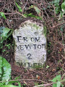
| Stone Type: | Milestone | |||||||||||||||||||||||||||||||||||||||||
| Grid Reference: | SX/8864/7128 | |||||||||||||||||||||||||||||||||||||||||
| Location: | On the grass verge and tight against the hedge, just to the west of the junction marked to Lower Netherton. | |||||||||||||||||||||||||||||||||||||||||
| Inscription: | From Newton 3 Miles | |||||||||||||||||||||||||||||||||||||||||
|
||||||||||||||||||||||||||||||||||||||||||
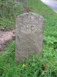
| Stone Type: | Boundary Stone | |||||||||||||||||||||||||||||||||||||||||
| Grid Reference: | SX/8828/7102 | |||||||||||||||||||||||||||||||||||||||||
| Location: | On the grass verge, on the south east side of the road and very close to the 40mph sign. | |||||||||||||||||||||||||||||||||||||||||
| Inscription: | H C (Haccombe with Combe) - The reverse side shows N A (Newton Abbot). | |||||||||||||||||||||||||||||||||||||||||