| |
|
|
|
|
|
|
|
|
|
|
|
|
| |
|
|
|
|
|
|
|
|
|
|
|
|
|
|
|
|
|
|
|
|
District: |
Teignbridge |
|
|
|
|
|
|
|
|
|
|
|
 |
|
| |
|
|
|
|
|
|
|
|
|
|
|
|
|
|
|
|
|
|
Parish: |
Hennock |
 |
 |
 |
|
|
|
|
| |
|
|
|
|
|
|
|
|
|
|
|
|
|
|
|
|
|
|
|
| |
|
|
|
|
|
|
|
|
|
|
|
|
|
|
|
|
|
|
|
| |
|
|
|
|
|
|
|
|
|
|
|
|
|
|
|
|
|
|
|
| Page
Contents: |
|
| |
2 Boundary Stones |
| |
2 Crosses |
| |
1 Cross Shaft |
| |
5 Guide Stones |
| |
6 Marker Stones |
| |
|
|
|
|
|
|
|
|
|
|
|
|
|
|
|
|
|
|
| |
|
|
|
|
|
|
|
|
|
|
|
|
|
| |
|
|
|
|
|
|
|
|
|
|
|
|
|
| |
|
|
|
|
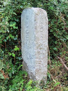
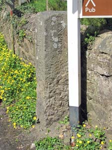
Stone Type: |
Guide Stone |
| |
|
|
|
|
Grid Reference: |
SX/8227/8085 |
| |
|
|
|
|
Location: |
At Cherrycombe Head Crossroads, about 800 metres west of Hennock village. |
| |
|
|
|
|
Inscription: |
To Bridford / To Moreton / To Bovey |
| |
|
|
|
|
|
|
|
|
|
| |
|
|
|
|
|
|
|
|
|
|
|
|
|
|
|
|
| |
|
|
|
|
|
|
|
|
|
|
|
|
|
|
|
|
|
|
|
|
|
|
|
|
|
|
|
|
|
|
|
|
| |
|
|
|
|
|
|
|
|
|
|
|
|
|
| |
|
|
|
|
|
|
|
|
|
|
|
|
|
|
|
|
|
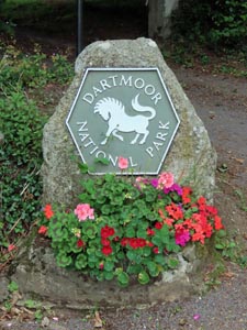
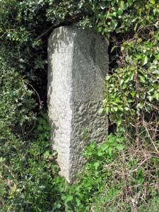
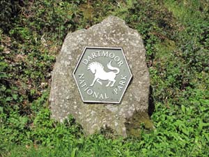
Stone Type: |
Boundary Stone |
|
|
|
|
|
|
|
|
|
Grid Reference: |
SX/8305/8015 |
|
|
|
|
|
|
|
|
|
Location: |
At the Five Lanes Crossroads, about 800 metres south of Hennock village. |
|
|
|
|
|
|
|
|
|
Inscription: |
Dartmoor National Park |
|
|
|
|
|
|
|
|
| |
|
|
|
|
|
|
|
|
|
| |
|
|
|
|
|
|
|
|
|
|
|
|
|
|
|
|
| |
|
|
|
|
|
|
|
|
|
|
|
|
|
|
|
|
| |
|
|
|
|
|
|
|
|
|
|
|
|
|
|
| |
|
|
|
|
|
|
|
|
|
|
|
|
|
| |
|
|
|
|
|
|
|
|
|
|
|
|
|
|
|
|
| |
|
|
|
|
|
|
|
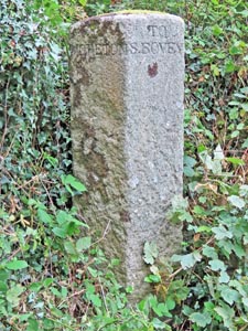
Stone Type: |
Guide Stone |
| |
|
|
|
|
|
|
|
Grid Reference: |
SX/8306/8015 |
| |
|
|
|
|
|
|
|
Location: |
At the Five Lanes Crossroads, about 800 metres south of Hennock village. |
| |
|
|
|
|
|
|
|
Inscription: |
To Moreton / To S. Bovey / To Chudleigh / To Exeter / To Hennock. |
| |
|
|
|
|
|
|
|
Notes: |
The
stone is five-sided to mark the direction of the 'Five Lanes'. |
| |
|
|
|
|
|
|
|
|
|
|
|
|
|
|
|
|
| |
|
|
|
|
|
|
|
|
|
|
|
|
|
|
|
|
|
|
|
|
|
|
|
|
|
|
|
|
|
|
|
|
| |
|
|
|
|
|
|
|
|
|
|
|
|
|
| |
|
|
|
|
|
|
|
|
|
|
|
|
|
|
|
|
|
Stone Type: |
Guide Stone |
|
|
|
|
|
|
|
|
|
Grid Reference: |
SX/8416/8088 |
|
|
|
|
|
|
|
|
|
Location: |
At the junction of the minor road leading to Teign Village, about 1.15
kilometres east of Hennock village. |
|
|
|
|
|
|
|
|
|
Inscription: |
To Hennock / To Exeter / To Bovey |
|
|
|
|
|
|
|
|
| |
|
|
|
|
|
|
|
|
|
| |
|
|
|
|
|
|
|
|
|
|
|
|
|
|
|
|
| |
|
|
|
|
|
|
|
|
|
|
|
|
|
|
|
|
| |
|
|
|
|
|
|
|
|
|
|
|
|
|
|
| |
|
|
|
|
|
|
|
|
|
|
|
|
|
| |
|
|
|
|
|
|
|
|
|
|
|
|
|
|
|
|
| |
|
|
|
|
|
|
|
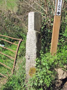
Stone Type: |
Guide Stone |
| |
|
|
|
|
|
|
|
Grid Reference: |
SX/8475/8114 |
| |
|
|
|
|
|
|
|
Location: |
Just off the B3193, on the lane leading to the former Hennock Railway
Station. |
| |
|
|
|
|
|
|
|
Inscription: |
To Exeter / To Chudleigh / To Hennock |
| |
|
|
|
|
|
|
|
|
|
| |
|
|
|
|
|
|
|
|
|
|
|
|
|
|
|
|
| |
|
|
|
|
|
|
|
|
|
|
|
|
|
|
|
|
|
|
|
|
|
|
|
|
|
|
|
|
|
|
|
|
| |
|
|
|
|
|
|
|
|
|
|
|
|
|
| |
|
|
|
|
|
|
|
|
|
|
|
|
|
|
|
|
|
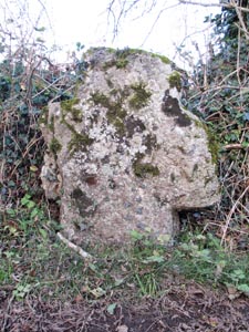
Stone Type: |
Cross Shaft & Base |
|
|
|
|
|
|
|
|
|
Grid Reference: |
SX/836/827 |
|
|
|
|
|
|
|
|
|
Location: |
In the grounds of of Canonteign House. |
|
|
|
|
|
|
|
|
|
Notes: |
The Cross Shaft & base stands within private grounds and may not be visited
without the permission of the landholder. |
|
|
|
|
|
|
|
|
| |
|
|
|
|
|
|
|
|
|
| |
|
|
|
|
|
|
|
|
|
|
|
|
|
|
|
|
| |
|
|
|
|
|
|
|
|
|
|
|
|
|
|
|
|
| |
|
|
|
|
|
|
|
|
|
|
|
|
|
|
| |
|
|
|
|
|
|
|
|
|
|
|
|
|
| |
|
|
|
|
|
|
|
|
|
|
|
|
|
|
|
|
| |
|
|
|
|
|
|
|
Stone Type: |
Guide Stone |
| |
|
|
|
|
|
|
|
Grid Reference: |
SX/8072/8206 |
| |
|
|
|
|
|
|
|
Location: |
At the Poolmill Crossroads, about 2.8 kilometres north west of Hennock
village. |
| |
|
|
|
|
|
|
|
Inscription: |
To Lustleigh / To Hennock |
| |
|
|
|
|
|
|
|
|
|
| |
|
|
|
|
|
|
|
|
|
|
|
|
|
|
|
|
| |
|
|
|
|
|
|
|
|
|
|
|
|
|
|
|
|
|
|
|
|
|
|
|
|
|
|
|
|
|
|
|
|
| |
|
|
|
|
|
|
|
|
|
|
|
|
|
| |
|
|
|
|
|
|
|
|
|
|
|
|
|
|
|
|
|
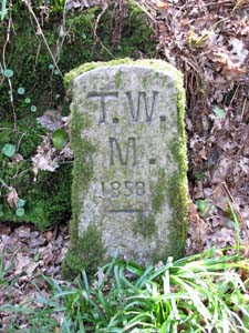
Stone Type: |
Marker Stone |
|
|
|
|
|
|
|
|
|
Grid Reference: |
SX/8221/8186 |
|
|
|
|
|
|
|
|
|
Location: |
At the side of the footpath through Great Rock Woods, between the Trenchford
Reservoir and Hennock. |
|
|
|
|
|
|
|
|
|
Inscription: |
T.W.M. 1858 (Torquay Water Main 1858) |
|
|
|
|
|
|
|
|
|
Notes: |
Marks the route of the water pipeline from the Trenchford, Tottiford and
Kennick Reservoirs to Torquay. |
|
|
|
|
|
|
|
|
| |
|
|
|
|
|
|
|
|
|
|
|
|
|
|
|
|
| |
|
|
|
|
|
|
|
|
|
|
|
|
|
|
|
|
| |
|
|
|
|
|
|
|
|
|
|
|
|
|
|
| |
|
|
|
|
|
|
|
|
|
|
|
|
|
| |
|
|
|
|
|
|
|
|
|
|
|
|
|
|
|
|
| |
|
|
|
|
|
|
|
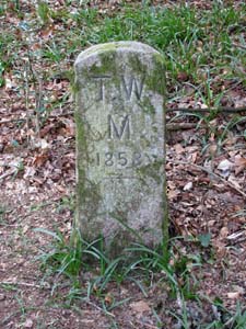
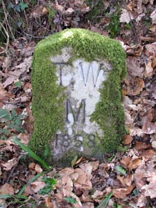
Stone Type: |
Marker Stone |
| |
|
|
|
|
|
|
|
Grid Reference: |
SX/8230/8178 |
| |
|
|
|
|
|
|
|
Location: |
At the side of the footpath through Great Rock Woods, between the Trenchford
Reservoir and Hennock. |
| |
|
|
|
|
|
|
|
Inscription: |
T.W.M. 1858 (Torquay Water Main 1858) |
| |
|
|
|
|
|
|
|
Notes: |
Marks the route of the water pipeline from the Trenchford, Tottiford and
Kennick Reservoirs to Torquay. |
| |
|
|
|
|
|
|
|
|
|
|
|
|
|
|
|
|
| |
|
|
|
|
|
|
|
|
|
|
|
|
|
|
|
|
|
|
|
|
|
|
|
|
|
|
|
|
|
|
|
|
| |
|
|
|
|
|
|
|
|
|
|
|
|
|
| |
|
|
|
|
|
|
|
|
|
|
|
|
|
|
|
|
|
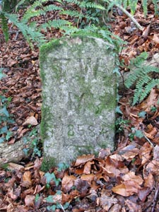
Stone Type: |
Marker Stone |
|
|
|
|
|
|
|
|
|
Grid Reference: |
SX/8243/8172 |
|
|
|
|
|
|
|
|
|
Location: |
At the side of the footpath through Great Rock Woods, between the Trenchford
Reservoir and Hennock. |
|
|
|
|
|
|
|
|
|
Inscription: |
T.W.M. 1858 (Torquay Water Main 1858) |
|
|
|
|
|
|
|
|
|
Notes: |
Marks the route of the water pipeline from the Trenchford, Tottiford and
Kennick Reservoirs to Torquay. |
|
|
|
|
|
|
|
|
| |
|
|
|
|
|
|
|
|
|
|
|
|
|
|
|
|
| |
|
|
|
|
|
|
|
|
|
|
|
|
|
|
|
|
| |
|
|
|
|
|
|
|
|
|
|
|
|
|
|
| |
|
|
|
|
|
|
|
|
|
|
|
|
|
| |
|
|
|
|
|
|
|
|
|
|
|
|
|
|
|
|
| |
|
|
|
|
|
|
|
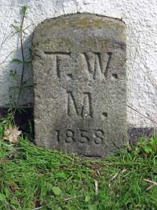
Stone Type: |
Marker Stone |
| |
|
|
|
|
|
|
|
Grid Reference: |
SX/8253/8166 |
| |
|
|
|
|
|
|
|
Location: |
At the side of the footpath through Great Rock Woods, between the Trenchford
Reservoir and Hennock. |
| |
|
|
|
|
|
|
|
Inscription: |
T.W.M. 1858 (Torquay Water Main 1858) |
| |
|
|
|
|
|
|
|
Notes: |
Marks the route of the water pipeline from the Trenchford, Tottiford and
Kennick Reservoirs to Torquay. |
| |
|
|
|
|
|
|
|
|
|
|
|
|
|
|
|
|
| |
|
|
|
|
|
|
|
|
|
|
|
|
|
|
|
|
|
|
|
|
|
|
|
|
|
|
|
|
|
|
|
|
| |
|
|
|
|
|
|
|
|
|
|
|
|
|
| |
|
|
|
|
|
|
|
|
|
|
|
|
|
|
|
|
|
Stone Type: |
Marker Stone |
|
|
|
|
|
|
|
|
|
Grid Reference: |
SX/8304/8100 |
|
|
|
|
|
|
|
|
|
Location: |
Against the wall of a house, on the eastern side of the lane leading north
from Hennock Church. |
|
|
|
|
|
|
|
|
|
Inscription: |
T.W.M. 1858 (Torquay Water Main 1858) |
|
|
|
|
|
|
|
|
|
Notes: |
Marks the route of the water pipeline from the Trenchford, Tottiford and
Kennick Reservoirs to Torquay. |
|
|
|
|
|
|
|
|
| |
|
|
|
|
|
|
|
|
|
|
|
|
|
|
|
|
| |
|
|
|
|
|
|
|
|
|
|
|
|
|
|
|
|
| |
|
|
|
|
|
|
|
|
|
|
|
|
|
| |
|
|
|
|
|
|
|
|
|
|
|
|
| |
|
|
|
|
|
|
Stone Type: |
Boundary Stone |
| |
|
|
|
|
|
|
Grid Reference: |
SX/8418/8175 |
| |
|
|
|
|
|
|
Location: |
At the junction of the B3193 with a minor road to Hennock. |
| |
|
|
|
|
|
|
Inscription: |
Dartmoor National Park |
| |
|
|
|
|
|
|
|
|
|
|
|
|
|
|
|
|
|
|
|
|
|
|
|
| |
|
|
|
|
|
|
|
|
|
|
|
|
|
|
|
|
|
|
|
|
|
|
|
|
|
|
|
|
|
|
Stone Type: |
Wayside
Cross |
|
|
|
|
|
|
|
|
|
Grid Reference: |
SX/7923/8292 |
|
|
|
|
|
|
|
|
|
Location: |
At
the side of the minor road, opposite the entrance to the lane leading to
Lower Elsford Farm. |
|
|
|
|
|
|
|
|
|
Notes: |
For
more information on this cross, see dartmoor-crosses.org.uk |
|
|
|
|
|
|
|
|
|
|
|
|
|
|
|
|
|
|
|
|
|
|
|
|
|
|
|
|
|
|
|
|
|
|
|
|
|
|
|
|
|
|
|
|
|
|
|
|
|
|
|
|
|
|
|
|
|
|
|
|
|
|
|
|
|
|
|
|
|
|
|
|
|
|
|
|
|
|
|
|
|
|
|
|
|
|
|
|
|
|
|
|
|
|
|
|
|
|
|
|
|
|
|
|
|
|
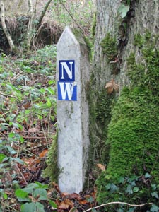
Stone Type: |
Marker
Stone |
|
|
|
|
|
|
|
|
Grid Reference: |
SX/8203/8190 |
|
|
|
|
|
|
|
|
Location: |
Beside
the track through Netton Wood |
|
|
|
|
|
|
|
|
Inscription: |
NW
(Netton Wood?) |
|
|
|
|
|
|
|
|
|
|
|
|
|
|
|
|
|
|
|
|
|
|
|
|
|
|
|
| |
|
|
|
|
|
|
|
|
|
|
|
|
|
|
|
|
|
|
|
|
|
|
|
|
|
|
|
|
|
|
|
|
|
|
|
|
|
|
|
|
|
|
|
|
|
|
|
|
|
|
|
|
|
|
|
|
|
|
|
|
|
|
|
|
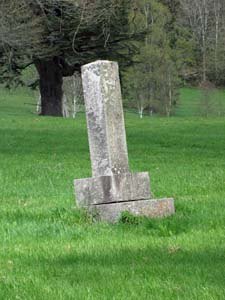
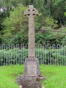
Stone Type: |
Village
Memorial Cross |
|
|
|
|
|
|
|
|
|
Grid Reference: |
SX/8323/8062 |
|
|
|
|
|
|
|
|
|
Location: |
Set
in a railed-off area on the west side of Church Road, Hennock. |
|
|
|
|
|
|
|
|
|
Inscription: |
In
Loving Memory of the Men of Hennock and Teign Village who gave their lives
in the Great War 1914-19. (Also 1939 - 1945) |
|
|
|
|
|
|
|
|
| Notes: |
The
cross serves as a Memorial for World War I and II. |
|
|
|
|
|
|
|
|
|
|
|
|
|
|
|
|
|
|
|
|
|
|
|
|
|
|
|
|
|
|
|
|
|
|
|
|
|
|
|
|
|
|
|
|
|
|
|
|
|
|
|
|
|
|
|
|
|
|
|
|
|
|
|
|
|
|
|
|
|
|
|
|
|
|
|
|
|
|
|
|
|
|
|
|
|
|
|
|
|
|
|
|
|
|
|
|
| |
|
|
|
|
|
|
|
|
|
|
|
|
|
|
|
|
|
|
|
|
|
|
|
|
|
|
|
|
|
|
|
|
|
|
|
|
|
|
|