|
Devon Marker Stones |

|
|||||||||||||||||||||
 |
 |
 |
 |
 |
|
||||||||||||||||||||||||||||||||||||||||||
| District: | Teignbridge |
|
||||||||||||||||||||||||||||||||||||||||
| Parish: | Holcombe Burnell | |||||||||||||||||||||||||||||||||||||||||
|
|
|||||||||||||||||||||||||||||||||||||||||
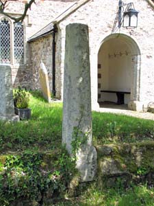
| Stone Type: | Churchyard Cross Shaft | |||||||||||||||||||||||||||||||||||||||||
| Grid Reference: | SX/8586/9159 | |||||||||||||||||||||||||||||||||||||||||
| Location: | Close to the path leading into the main entrance to Holcombe Burnell Church | |||||||||||||||||||||||||||||||||||||||||
| Notes: | This cross shaft is thought to be late medieval and sits on a contemporary churchyard boundary wall. | |||||||||||||||||||||||||||||||||||||||||
|
||||||||||||||||||||||||||||||||||||||||||
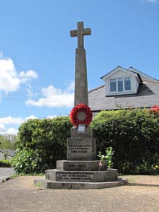
| Stone Type: | Village Cross | |||||||||||||||||||||||||||||||||||||||||
| Grid Reference: | SX/8651/9111 | |||||||||||||||||||||||||||||||||||||||||
| Location: | In the centre of Longdown, in the fork formed by the B3212 and the minor road to Holcombe Burnell. | |||||||||||||||||||||||||||||||||||||||||
| Notes: | The cross serves as the village war memorial. | |||||||||||||||||||||||||||||||||||||||||
|
||||||||||||||||||||||||||||||||||||||||||
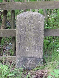
| Stone Type: | Milestone | |||||||||||||||||||||||||||||||||||||||||
| Grid Reference: | SX/8903/9195 | |||||||||||||||||||||||||||||||||||||||||
| Location: | On the south west side of the road from Pocombe Bridge to Tedburn St Mary, against the A30 road fence. | |||||||||||||||||||||||||||||||||||||||||
| Inscription: | 2 Miles from Exon (Exeter) | |||||||||||||||||||||||||||||||||||||||||
| Notes: | The bottom of the stone shows an Ordnance Survey Benchmark. | |||||||||||||||||||||||||||||||||||||||||
|
||||||||||||||||||||||||||||||||||||||||||
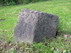
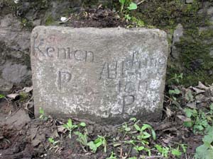
| Stone Type: | Boundary Stone | |||||||||||||||||||||||||||||||||||||||||
| Grid Reference: | SX/8841/9263 | |||||||||||||||||||||||||||||||||||||||||
| Location: | On the south side of the road from Pocombe Bridge to Tedburn St Mary, 15 metres to the east of its junction with Cutteridge Lane. | |||||||||||||||||||||||||||||||||||||||||
| Inscription: | Alphington P / Kenton P (Parish) | |||||||||||||||||||||||||||||||||||||||||
| Notes: | Although the stone now lies on the border of the Parishes of Holcombe Burnell and Whitestone, it originally marked the boundary of Alphington and Kenton whose parishes were then much larger than they are today. | |||||||||||||||||||||||||||||||||||||||||
|
||||||||||||||||||||||||||||||||||||||||||
| Stone Type: | Boundary Stone | |||||||||||||||||||||||||||||||||||||||||
| Grid Reference: | SX/8819/9269 | |||||||||||||||||||||||||||||||||||||||||
| Location: | Set against the southern parapet of the bridge over the Alphin Brook on the road from Pocombe Bridge to Tedburn St Mary. | |||||||||||||||||||||||||||||||||||||||||
| Inscription: | Kenton P / Alphington P (Parish) | |||||||||||||||||||||||||||||||||||||||||
| Notes: | Although the stone now lies on the border of the Parishes of Holcombe Burnell and Whitestone, it originally marked the boundary of Alphington and Kenton whose parishes were then much larger than they are today. | |||||||||||||||||||||||||||||||||||||||||