| |
|
|
|
|
|
|
|
|
|
|
|
|
| |
|
|
|
|
|
|
|
|
|
|
|
|
|
|
|
|
|
|
|
|
District: |
Teignbridge |
|
|
|
|
|
|
|
|
|
|
|
 |
|
| |
|
|
|
|
|
|
|
|
|
|
|
|
|
|
|
|
|
|
Parish: |
Ilsington |
 |
 |
 |
|
|
|
|
| |
|
|
|
|
|
|
|
|
|
|
|
|
|
|
|
|
|
|
|
| |
|
|
|
|
|
|
|
|
|
|
|
|
|
|
|
|
|
|
|
| |
|
|
|
|
|
|
|
|
|
|
|
|
|
|
|
|
|
|
|
| Page
Contents: |
|
| |
6 Boundary Stones |
| |
1 Cross |
| |
7
Guide Stones |
| |
2
Marker Stones |
| |
3
Milestones |
| |
|
|
|
|
|
|
|
|
|
|
|
|
|
|
|
|
|
|
| |
|
|
|
|
|
|
|
|
|
|
|
|
|
| |
|
|
|
|
|
|
|
|
|
|
|
|
|
| |
|
|
|
|
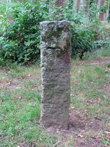
Stone Type: |
Hook Cross |
| |
|
|
|
|
Grid Reference: |
SX/7788/7265 |
| |
|
|
|
|
Location: |
At the Hook Crossroads, about 900 metres north west of the Newton Abbot
junction off the A38 dual-carriageway. |
| |
|
|
|
|
Notes: |
For
more information on this cross, see dartmoor-crosses.org.uk |
| |
|
|
|
|
|
|
|
|
|
| |
|
|
|
|
|
|
|
|
|
|
|
|
|
|
|
|
| |
|
|
|
|
|
|
|
|
|
|
|
|
|
|
|
|
|
|
|
|
|
|
|
|
|
|
|
|
|
|
|
|
| |
|
|
|
|
|
|
|
|
|
|
|
|
|
| |
|
|
|
|
|
|
|
|
|
|
|
|
|
|
|
|
|
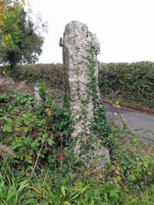
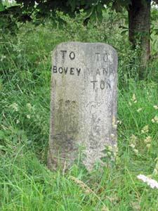
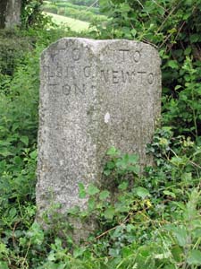
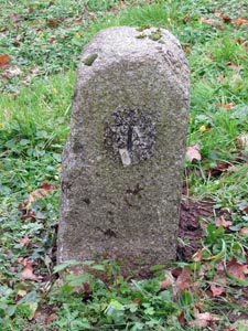
Stone Type: |
Guide Stone |
|
|
|
|
|
|
|
|
|
Grid Reference: |
SX/7821/7490 |
|
|
|
|
|
|
|
|
|
Location: |
On the grass verge at Five Lanes Cross, about 1¼ kilometres south of
Ilsington village. |
|
|
|
|
|
|
|
|
|
Inscription: |
To Bovey / To Manaton / To Ashburton / To Newton. |
|
|
|
|
|
|
|
|
| |
|
|
|
|
|
|
|
|
|
| |
|
|
|
|
|
|
|
|
|
|
|
|
|
|
|
|
| |
|
|
|
|
|
|
|
|
|
|
|
|
|
|
|
|
| |
|
|
|
|
|
|
|
|
|
|
|
|
|
|
| |
|
|
|
|
|
|
|
|
|
|
|
|
|
| |
|
|
|
|
|
|
|
|
|
|
|
|
|
|
|
|
| |
|
|
|
|
|
|
|
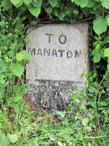
Stone Type: |
Guide Stone |
| |
|
|
|
|
|
|
|
Grid Reference: |
SX/7769/7526 |
| |
|
|
|
|
|
|
|
Location: |
Set back into the hedge at Sigford Cross, about 1¼ kilometres south west of
Ilsington village. |
| |
|
|
|
|
|
|
|
Inscription: |
To Manaton. |
| |
|
|
|
|
|
|
|
Notes: |
Only one face is visible as the other three are set back into the hedge. |
| |
|
|
|
|
|
|
|
|
|
|
|
|
|
|
|
|
| |
|
|
|
|
|
|
|
|
|
|
|
|
|
|
|
|
|
|
|
|
|
|
|
|
|
|
|
|
|
|
|
|
| |
|
|
|
|
|
|
|
|
|
|
|
|
|
| |
|
|
|
|
|
|
|
|
|
|
|
|
|
|
|
|
|
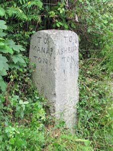
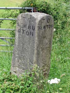
Stone Type: |
Guide Stone |
|
|
|
|
|
|
|
|
|
Grid Reference: |
SX/7790/7583 |
|
|
|
|
|
|
|
|
|
Location: |
At the road junction to the south west corner of the Ilsington Playing
Fields. |
|
|
|
|
|
|
|
|
|
Inscription: |
To Manaton / To Ashburton / To Ilsington. |
|
|
|
|
|
|
|
|
| |
|
|
|
|
|
|
|
|
|
| |
|
|
|
|
|
|
|
|
|
|
|
|
|
|
|
|
| |
|
|
|
|
|
|
|
|
|
|
|
|
|
|
|
|
| |
|
|
|
|
|
|
|
|
|
|
|
|
|
|
| |
|
|
|
|
|
|
|
|
|
|
|
|
|
| |
|
|
|
|
|
|
|
|
|
|
|
|
|
|
|
|
| |
|
|
|
|
|
|
|
Stone Type: |
Guide Stone |
| |
|
|
|
|
|
|
|
Grid Reference: |
SX/7945/7642 |
| |
|
|
|
|
|
|
|
Location: |
At Woodhouse Cross, about 1 kilometre east of Ilsington village. |
| |
|
|
|
|
|
|
|
Inscription: |
To Ilsington / To Newton / To Manaton / To Bovey. |
| |
|
|
|
|
|
|
|
|
|
| |
|
|
|
|
|
|
|
|
|
|
|
|
|
|
|
|
| |
|
|
|
|
|
|
|
|
|
|
|
|
|
|
|
|
|
|
|
|
|
|
|
|
|
|
|
|
|
|
|
|
| |
|
|
|
|
|
|
|
|
|
|
|
|
|
|
|
|
|
|
|
|
|
|
|
|
|
|
|
|
|
|
|
Stone Type: |
Guide Stone |
|
|
|
|
|
|
|
|
|
Grid Reference: |
SX/7995/7530 |
|
|
|
|
|
|
|
|
|
Location: |
On the grass verge at Willis's Crossroads, about 600 metres west of the
village of Liverton (old part). |
|
|
|
|
|
|
|
|
|
Inscription: |
To Ashburton / To Newton / To Ilsington. |
|
|
|
|
|
|
|
|
|
|
|
|
|
|
|
|
|
|
|
|
|
|
|
|
|
|
|
|
|
|
|
|
|
|
|
|
|
|
|
|
|
|
|
|
|
|
|
|
|
|
|
|
|
|
|
|
|
|
|
|
|
|
|
|
|
|
|
|
|
|
|
|
|
|
|
|
|
|
|
|
|
|
|
|
|
|
|
|
|
|
|
|
|
|
|
|
|
|
|
|
|
|
|
|
|
|
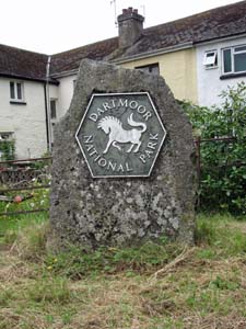
Stone Type: |
Boundary Stone |
|
|
|
|
|
|
|
|
Grid Reference: |
SX/8138/7507 |
|
|
|
|
|
|
|
|
Location: |
On the grass verge in front of a row of houses, on the south west corner of
the crossroads. |
|
|
|
|
|
|
|
|
Inscription: |
Dartmoor National Park. |
|
|
|
|
|
|
|
|
|
|
|
|
|
|
|
|
|
|
|
|
|
|
|
|
|
|
|
| |
|
|
|
|
|
|
|
|
|
|
|
|
|
|
|
|
|
|
|
|
|
|
|
|
|
|
|
|
|
|
|
|
|
|
|
|
|
|
|
|
|
|
|
|
|
|
|
|
|
|
|
|
|
|
|
|
|
|
|
|
|
|
|
|
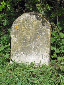
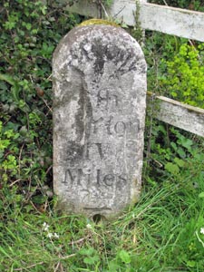
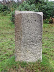
Stone Type: |
Milestone |
|
|
|
|
|
|
|
|
|
Grid Reference: |
SX/8173/7460 |
|
|
|
|
|
|
|
|
|
Location: |
On the north side of the A38, at the eastern end of Benedict's Bridge. |
|
|
|
|
|
|
|
|
|
Inscription: |
From Ashburton V (Five Miles). |
|
|
|
|
|
|
|
|
|
Notes: |
The inscription has become very badly eroded and only parts of it can now be
read. |
|
|
|
|
|
|
|
|
|
|
|
|
|
|
|
|
|
|
|
|
|
|
|
|
|
|
|
|
|
|
|
|
|
|
|
|
|
|
|
|
|
|
|
|
|
|
|
|
|
|
|
|
|
|
|
|
|
|
|
|
|
|
|
|
|
|
|
|
|
|
|
|
|
|
|
|
|
|
|
|
|
|
|
|
|
|
|
|
|
|
|
|
|
|
|
|
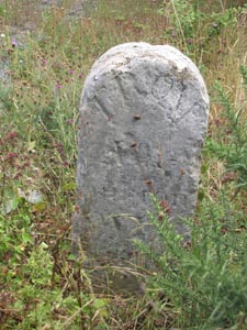
Stone Type: |
Milestone |
|
|
|
|
|
|
|
|
Grid Reference: |
SX/8063/7351 |
|
|
|
|
|
|
|
|
Location: |
On the south east side of the A38, between the iron mesh double gates and
the wooden fence. |
|
|
|
|
|
|
|
|
Inscription: |
From Ashburton IV (Four) Miles |
|
|
|
|
|
|
|
|
Notes: |
The inscription has now become partly eroded. |
|
|
|
|
|
|
|
|
|
|
|
|
|
|
|
|
|
|
|
|
|
|
|
|
|
|
|
|
|
|
|
|
|
|
|
|
|
|
|
|
|
|
|
|
|
|
|
|
|
|
|
|
|
|
|
|
|
|
|
|
|
|
|
|
|
|
|
|
|
|
|
|
|
|
|
|
|
|
|
|
|
|
Stone Type: |
Milestone |
|
|
|
|
|
|
|
|
|
Grid Reference: |
SX/8309/7540 |
|
|
|
|
|
|
|
|
|
Location: |
On
the south-east verge of the Devon Expressway, near the end of the slip
road and next to a Clearway sign. |
|
|
|
|
|
|
|
|
|
Inscription: |
From
Ashburton VI Miles |
|
|
|
|
|
|
|
|
|
|
|
|
|
|
|
|
|
|
|
|
|
|
|
|
|
|
|
|
|
|
|
|
|
|
|
|
|
|
|
|
|
|
|
|
|
|
|
|
|
|
|
|
|
|
|
|
|
|
|
|
|
|
|
|
|
|
|
|
|
|
|
|
|
|
|
|
|
|
|
|
|
|
|
|
|
|
|
|
|
|
|
|
|
|
|
|
|
|
|
|
|
|
|
|
|
|
Stone Type: |
Boundary
Stone |
|
|
|
|
|
|
|
|
Grid Reference: |
SX/8309/7506 |
|
|
|
|
|
|
|
|
Location: |
On
the north-east verge of the A382, at the entrance of the cycle path to the
Stover Country Park. |
|
|
|
|
|
|
|
|
Inscription: |
I
L S (Ilsington) |
|
|
|
|
|
|
|
|
Notes: |
The
stone shares its border with the Parish of Newton Abbot. |
|
|
|
|
|
|
|
|
|
|
|
|
|
|
|
|
|
|
|
|
|
|
|
|
|
|
|
|
|
|
|
|
|
|
|
|
|
|
|
|
|
|
|
|
|
|
|
|
|
|
|
|
|
|
|
|
|
|
|
|
|
|
|
|
|
|
|
|
|
|
|
|
|
|
|
|
|
|
|
|
|
|
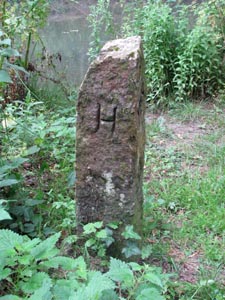
Stone Type: |
Boundary
Stone |
|
|
|
|
|
|
|
|
|
Grid Reference: |
SX/8323/7522 |
|
|
|
|
|
|
|
|
|
Location: |
Beside
the cycle path through the Stover Country Park, near the north-west end of
the lake. |
|
|
|
|
|
|
|
|
|
Inscription: |
H
/ T / W / B (Haytor / Tram / Way / Bounds) |
|
|
|
|
|
|
|
|
|
Notes: |
This
is one of two stones that marked the boundary of the Haytor Tramway on
each side of the nearby Devon Expressway Dual-Carriageway. |
|
|
|
|
|
|
|
|
|
|
|
|
|
|
|
|
|
|
|
|
|
|
|
|
|
|
|
|
|
|
|
|
|
|
|
|
|
|
|
|
|
|
|
|
|
|
|
|
|
|
|
|
|
|
|
|
|
|
|
|
|
|
|
|
|
|
|
|
|
|
|
|
|
|
|
|
|
|
|
|
|
|
|
|
|
|
|
Stone Type: |
Boundary
Stone |
|
|
|
|
|
|
|
|
Grid Reference: |
SX/8323/7522 |
|
|
|
|
|
|
|
|
Location: |
Beside
the cycle path through the Stover Country Park, near the north-west end of
the lake. |
|
|
|
|
|
|
|
|
Inscription: |
H
/ T / W / B (Haytor / Tram / Way / Bounds) |
|
|
|
|
|
|
|
|
Notes: |
This
is one of two stones that marked the boundary of the Haytor Tramway on
each side of the nearby Devon Expressway Dual-Carriageway. |
|
|
|
|
|
|
|
|
|
|
|
|
|
|
|
|
|
|
|
|
|
|
|
|
|
|
|
|
|
|
|
|
|
|
|
|
|
|
|
|
|
|
|
|
|
|
|
|
|
|
|
|
|
|
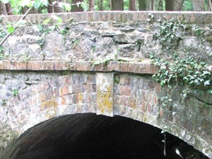
Stone Type: |
Marker
Stone |
|
|
|
|
|
|
|
|
Grid Reference: |
SX/8374/7495 |
|
|
|
|
|
|
|
|
Location: |
The
keystone on the eastern arch of a bridge in the Stover Country Park. |
|
|
|
|
|
|
|
|
Inscription: |
1877 |
|
|
|
|
|
|
|
|
Notes: |
The
stone records the date the bridge was built. |
|
|
|
|
|
|
|
|
|
|
|
|
|
|
|
|
|
|
|
|
|
|
|
|
|
|
|
|
|
|
|
|
|
|
|
|
|
|
|
|
|
|
|
|
|
|
|
|
|
|
|
|
|
|
|
|
|
|
|
|
|
|
|
|
|
|
|
|
|
|
|
|
|
|
|
|
Stone Type: |
Boundary
Stone |
|
|
|
|
|
|
|
|
Grid Reference: |
SX/8331/7467 |
|
|
|
|
|
|
|
|
Location: |
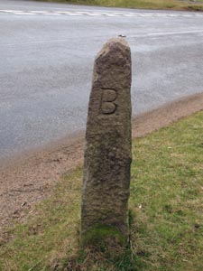
On
the western verge of the A382, just south of the roundabout. |
|
|
|
|
|
|
|
|
Inscription: |
I
(Ilsington) |
|
|
|
|
|
|
|
|
Notes: |
The
stone shares it's Boundary with Newton Abbot |
|
|
|
|
|
|
|
|
|
|
|
|
|
|
|
|
|
|
|
|
|
|
|
|
|
|
|
|
|
|
|
|
|
|
|
|
|
|
|
|
|
|
|
|
|
|
|
|
|
|
|
|
|
|
|
|
|
|
|
|
|
|
|
|
|
Stone Type: |
Guide
Stone |
|
|
|
|
|
|
|
|
|
Grid Reference: |
SX/7682/7737 |
|
|
|
|
|
|
|
|
|
Location: |
Beside
the B3357 at Haytor Vale. |
|
|
|
|
|
|
|
|
|
Inscription: |
To
Ashburton / To Manaton |
|
|
|
|
|
|
|
|
|
Notes: |
The
inscription has now almost been worn away. |
|
|
|
|
|
|
|
|
|
|
|
|
|
|
|
|
|
|
|
|
|
|
|
|
|
|
|
|
|
|
|
|
|
|
|
|
|
|
|
|
|
|
|
|
|
|
|
|
|
|
|
|
|
|
|
|
|
|
|
|
|
|
|
|
|
|
|
|
|
|
|
|
|
|
|
|
|
|
|
|
|
|
|
|
|
|
|
|
|
|
|
|
|
|
|
|
Stone Type: |
Guide
Stone |
|
|
|
|
|
|
|
|
Grid Reference: |
SX/7418/7610 |
|
|
|
|
|
|
|
|
Location: |
On
the grass verge at Hemsworthy Gate. |
|
|
|
|
|
|
|
|
Inscription: |
B
(Buckfastleigh) / M (Manaton) / A (Ashburton) |
|
|
|
|
|
|
|
|
|
|
|
|
|
|
|
|
|
|
|
|
|
|
|
|
|
|
|
|
|
|
|
|
|
|
|
|
|
|
|
|
|
|
|
|
|
|
|
|
|
|
|
|
|
|
|
|
|
|
|
|
|
|
|
|
|
|
|
|
|
|
|
|
|
Stone Type: |
Marker
Stone |
|
|
|
|
|
|
|
|
Grid Reference: |
SX/7656/7717 |
|
|
|
|
|
|
|
|
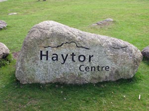
Location: |
Beside
the entrance to the lower Haytor Car Park. |
|
|
|
|
|
|
|
|
Inscription: |
Haytor
Centre. |
|
|
|
|
|
|
|
|
|
|
|
|
|
|
|
|
|
|
|
|
|
|
|
|
|
|
|
|
|
|
|
|
|
|
|
|
|
|
|
|
|
|
|
|
|
|
|
|
|
|
|
|
|
|
|
|
|
|
|
|
|
|
|
|
|
|
|
|
Stone Type: |
Boundary Stone |
|
|
|
|
|
|
|
|
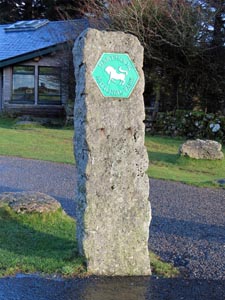
Grid Reference: |
SX/7655/7714 |
|
|
|
|
|
|
|
|
Location: |
Near
the Information Centre at the Haytor (Lower) Car Park. |
|
|
|
|
|
|
|
|
Inscription: |
Dartmoor National Park. |
|
|
|
|
|
|
|
|
|
|
|
|
|
|
|
|
|
|
|
|
|
|
|
|
|
|
|
|
|
|
|
|
|
|
|
|
|
|
|
|
|
|
|
|
|
|
|
|
|
|
|
|
|
|
|
|
|
|
|
|
|
|
|
|
|
|
|
|
|
|
|
|
|
|
|
|
|
|
|
|
|
|
|
|
|
|
|
|
|
|
|
|
|
|
|
|
|
|
| |
|
|
|
|
|
|
|
|
|
|
|
|
|
|
|
|
|
|
|
|
|
|
|
|
|
|
|
|
|
|
|
|
|
|
|
|
|
|
|