| |
|
|
|
|
|
|
|
|
|
|
|
|
| |
|
|
|
|
|
|
|
|
|
|
|
|
|
|
|
|
|
|
|
|
District: |
West
Devon |
|
|
|
|
|
|
|
|
|
|
|
 |
|
| |
|
|
|
|
|
|
|
|
|
|
|
|
|
|
|
|
|
|
Parish: |
Dartmoor
Forest |
 |
 |
 |
|
|
|
|
| |
|
|
|
|
|
|
|
|
|
|
|
|
|
|
|
|
|
|
|
| |
|
|
|
|
|
|
|
|
|
|
|
|
|
|
|
|
|
|
|
| |
|
|
|
|
|
|
|
|
|
|
|
|
|
|
|
|
|
|
|
| Page
Contents: |
|
| |
4 Boundary Stones |
| |
1 Cross |
| |
1
Marker Stone |
| |
10
Milestones |
| |
|
| |
|
|
|
|
|
|
|
|
|
|
|
|
|
|
|
|
|
|
| |
|
|
|
|
|
|
|
|
|
|
|
|
|
| |
|
|
|
|
|
|
|
|
|
|
|
|
|
| |
|
|
|
|
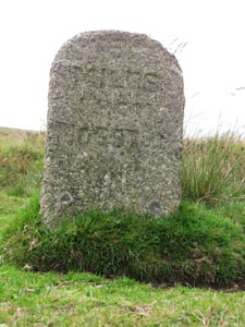
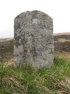
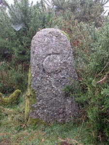
Stone Type: |
Milestone |
| |
|
|
|
|
Grid Reference: |
SX/6772/8130 |
| |
|
|
|
|
Location: |
On
the grass verge of the B3212, 500 yards north-east of the Warren House
Inn. |
| |
|
|
|
|
Inscription: |
6
Miles From Moreton (Morehampstead). |
| |
|
|
|
|
|
|
|
|
|
| |
|
|
|
|
|
|
|
|
|
|
|
|
|
|
|
|
| |
|
|
|
|
|
|
|
|
|
|
|
|
|
|
|
|
|
|
|
|
|
|
|
|
|
|
|
|
|
|
|
|
| |
|
|
|
|
|
|
|
|
|
|
|
|
|
|
|
|
|
|
|
|
|
|
|
|
|
|
|
|
|
|
|
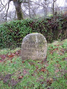
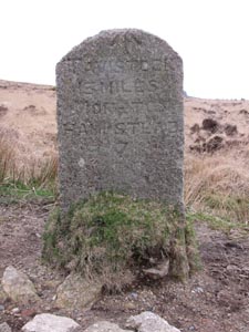
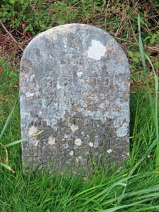
Stone Type: |
Milestone |
|
|
|
|
|
|
|
|
|
Grid Reference: |
SX/6523/7927 |
|
|
|
|
|
|
|
|
|
Location: |
On
the grass verge of the B3212 at Postbridge |
|
|
|
|
|
|
|
|
|
Inscription: |
Tavistock
12 Miles / Moretonhampstead 8 |
|
|
|
|
|
|
|
|
|
|
|
|
|
|
|
|
|
|
|
|
|
|
|
|
|
|
|
|
|
|
|
|
|
|
|
|
|
|
|
|
|
|
|
|
|
|
|
|
|
|
|
|
|
|
|
|
|
|
|
|
|
|
|
|
|
|
|
|
|
|
|
|
|
|
|
|
|
|
|
|
|
|
|
|
|
|
|
|
|
|
|
|
|
|
|
|
|
|
|
|
|
|
|
|
|
|
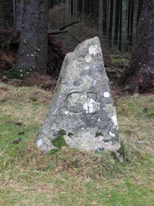
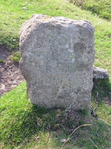
Stone Type: |
Boundary
Stone |
|
|
|
|
|
|
|
|
Grid Reference: |
SX/6763/7860 |
|
|
|
|
|
|
|
|
Location: |
At
the side of the unclassified road that runs across the southern boundary
of Soussons Forest |
|
|
|
|
|
|
|
|
Inscription: |
CB
(Cator Bounds) |
|
|
|
|
|
|
|
|
Notes: |
The
stone is one of a number that marks the boundary of Cator Manor |
|
|
|
|
|
|
|
|
|
|
|
|
|
|
|
|
|
| |
|
|
|
|
|
|
|
|
|
|
|
|
|
|
|
|
|
|
|
|
|
|
|
|
|
|
|
|
|
|
|
|
|
|
|
|
|
|
|
|
|
|
|
|
|
|
|
|
|
|
|
|
|
|
|
|
|
|
|
|
|
|
|
|
|
|
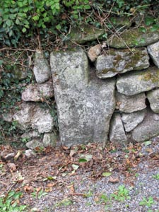
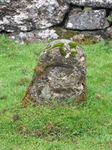
Stone Type: |
Postbridge
Cross Head |
|
|
|
|
|
|
|
|
|
Grid Reference: |
SX/6516/7922 |
|
|
|
|
|
|
|
|
|
Location: |
Built
into the entrance wall of Stannon Lodge. |
|
|
|
|
|
|
|
|
|
Notes: |
Further
details of the cross may be found at Postbridge
Cross |
|
|
|
|
|
|
|
|
|
|
|
|
|
|
|
|
|
|
|
|
|
|
|
|
|
|
|
|
|
|
|
|
|
|
|
|
|
|
|
|
|
|
|
|
|
|
|
|
|
|
|
|
|
|
|
|
|
|
|
|
|
|
|
|
|
|
|
|
|
|
|
|
|
|
|
|
|
|
|
|
|
|
|
|
|
|
|
|
|
|
|
|
|
|
|
|
|
|
|
|
|
|
|
|
|
|
|
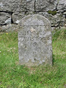
Stone Type: |
Milestone |
|
|
|
|
|
|
|
|
Grid Reference: |
SX/6659/7345 |
|
|
|
|
|
|
|
|
Location: |
On
the B3357, at the entrance lane to Brimpts Farm. |
|
|
|
|
|
|
|
|
|
Inscription: |
Ashburton
8 Miles / Tavistock 12. |
|
|
|
|
|
|
|
|
|
|
|
|
|
|
|
|
|
|
|
|
|
|
|
|
|
|
|
|
|
| |
|
|
|
|
|
|
|
|
|
|
|
|
|
|
|
|
|
|
|
|
|
|
|
|
|
|
|
|
|
|
|
|
|
|
|
|
|
|
|
|
|
|
|
|
|
|
|
|
|
|
|
|
|
|
|
|
|
|
|
|
|
|
|
|
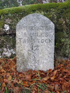
Stone Type: |
Milestone |
|
|
|
|
|
|
|
|
|
Grid Reference: |
SX/6228/7471 |
|
|
|
|
|
|
|
|
|
Location: |
Beside
the B3357, west of the entrance to the Prince Hall Hotel. |
|
|
|
|
|
|
|
|
|
Inscription: |
Ashburton
11 Miles / Tavistock 9. |
|
|
|
|
|
|
|
|
|
|
|
|
|
|
|
|
|
|
|
|
|
|
|
|
|
|
|
|
|
|
|
|
|
|
|
|
|
|
|
|
|
|
|
|
|
|
|
|
|
|
|
|
|
|
|
|
|
|
|
|
|
|
|
|
|
|
|
|
|
|
|
|
|
|
|
|
|
|
|
|
|
|
|
|
|
|
|
|
|
|
|
|
|
|
|
|
|
|
|
|
|
|
|
|
|
|
Stone Type: |
Milestone |
|
|
|
|
|
|
|
|
Grid Reference: |
SX/6208/7583 |
|
|
|
|
|
|
|
|
Location: |
On
the northern verge of the B3212, 120 yards south west of the entrance to
the Cherrybrook Hotel |
|
|
|
|
|
|
|
|
Inscription: |
Tavistock
9 Miles / Moretonhampstead 11. |
|
|
|
|
|
|
|
|
|
|
|
|
|
|
|
|
|
|
|
|
|
|
|
|
|
|
|
|
|
|
|
|
|
|
|
|
|
|
|
|
|
|
|
|
|
|
|
|
|
|
|
|
|
|
|
|
|
|
|
|
|
|
|
|
|
|
|
|
|
|
|
|
|
|
|
|
|
|
|
|
|
|
|
|
|
|
|
|
|
|
|
|
Stone Type: |
Milestone |
|
|
|
|
|
|
|
|
|
Grid Reference: |
SX/6318/7682 |
|
|
|
|
|
|
|
|
|
Location: |
On
the north west verge of the B3212, 250 yards south west of the Cherrybrook
Bridge. |
|
|
|
|
|
|
|
|
|
|
|
|
|
|
|
|
|
Inscription: |
Tavistock
10 Miles / Moretonhampstead 10. |
|
|
|
|
|
|
|
|
|
|
|
|
|
|
|
|
|
|
|
|
|
|
|
|
|
|
|
|
|
|
|
|
|
|
|
|
|
|
|
|
|
|
|
|
|
|
|
|
|
|
|
|
|
|
|
|
|
|
|
|
|
|
|
|
|
|
|
|
|
|
|
|
|
|
|
|
|
|
|
|
|
|
|
|
|
|
|
|
|
|
|
|
|
|
|
|
Stone Type: |
Milestone |
|
|
|
|
|
|
|
|
Grid Reference: |
SX/640/781 |
|
|
|
|
|
|
|
|
Location: |
On
the north west verge of the B3212, 500 yards south west of the entrance
lane to Archerton. |
|
|
|
|
|
|
|
|
|
|
|
|
|
|
|
|
Inscription: |
Tavistock
11 Miles / Moretonhampstead 9. |
|
|
|
|
|
|
|
|
|
|
|
|
|
|
|
|
|
|
|
|
|
|
|
|
|
|
|
|
|
|
|
|
|
|
|
|
|
|
|
|
|
|
|
|
|
|
|
|
|
|
|
|
|
|
|
|
|
|
|
|
|
|
|
|
|
|
|
|
|
|
|
|
|
|
|
|
|
|
|
|
|
|
Stone Type: |
Milestone |
|
|
|
|
|
|
|
|
|
Grid Reference: |
SX/6646/8035 |
|
|
|
|
|
|
|
|
|
Location: |
On
the north west verge of the B3212, 350 yards south west of the Stat's
Bridge. |
|
|
|
|
|
|
|
|
|
|
|
|
|
|
|
|
|
Inscription: |
Tavistock
13 Miles / Moretonhampstead 7. |
|
|
|
|
|
|
|
|
|
|
|
|
|
|
|
|
|
|
|
|
|
|
|
|
|
|
|
|
|
|
|
|
|
|
|
|
|
|
|
|
|
|
|
|
|
|
|
|
|
|
|
|
|
|
|
|
|
|
|
|
|
|
|
|
|
|
|
|
|
|
|
|
|
|
|
|
|
|
|
|
|
|
|
|
|
|
|
|
|
|
|
|
|
|
|
|
Stone Type: |
Milestone |
|
|
|
|
|
|
|
|
Grid Reference: |
SX/6873/8253 |
|
|
|
|
|
|
|
|
Location: |
On
the western verge of the B3212, 340 yards south west of the junction with
the minor road leading off to Jurston. |
|
|
|
|
|
|
|
|
|
|
|
|
|
|
|
|
Inscription: |
Tavistock
15 Miles / Moretonhampstead 5. |
|
|
|
|
|
|
|
|
|
|
|
|
|
|
|
|
|
|
|
|
|
|
|
|
|
|
|
|
|
|
|
|
|
|
|
|
|
|
|
|
|
|
|
|
|
|
|
|
|
|
|
|
|
|
|
|
|
|
|
|
|
|
|
|
|
|
|
|
|
|
|
|
|
|
|
|
|
|
|
|
|
|
Stone Type: |
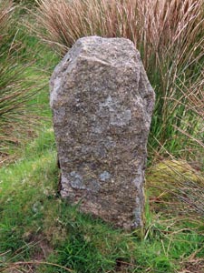
Boundary
Stone |
|
|
|
|
|
|
|
|
|
Grid Reference: |
SX/6573/7733 |
|
|
|
|
|
|
|
|
|
Location: |
On
the south verge of the road, west of Bellever Bridge |
|
|
|
|
|
|
|
|
|
Inscription: |
C
- (County Bridge Stone - see note on Home Page) |
|
|
|
|
|
|
|
|
|
|
|
|
|
|
|
|
|
|
|
|
|
|
|
|
|
|
|
|
|
|
|
|
|
|
|
|
|
|
|
|
|
|
|
|
|
|
|
|
|
|
|
|
|
|
|
|
|
|
|
|
|
|
|
|
|
|
|
|
|
|
|
|
|
|
|
|
|
|
|
|
|
|
|
|
|
|
|
|
|
|
|
|
|
|
|
|
|
|
|
|
|
|
|
|
|
|
Stone
Type: |
Boundary
Stone |
|
|
|
|
|
|
|
|
Grid
Reference: |
SX/6590/7740 |
|
|
|
|
|
|
|
|
Location: |
On
the north verge of the road, east of Bellever Bridge, half hidden by
gorse. |
|
|
|
|
|
|
|
|
|
|
|
|
|
|
|
|
Inscription: |
C
- (County Bridge Stone - see note on Home Page) |
|
|
|
|
|
|
|
|
|
|
|
|
|
|
|
|
|
|
|
|
|
|
|
|
|
|
|
|
|
|
|
|
|
|
|
|
|
|
|
|
|
|
|
|
|
|
|
|
|
|
|
|
|
|
|
|
|
|
|
|
|
|
|
|
|
|
|
|
|
|
|
|
|
|
|
|
|
|
|
|
|
| Stone
Type: |
Boundary
Stone |
|
|
|
|
|
|
|
|
| Grid
Reference: |
SX/6029/7506 |
|
|
|
|
|
|
|
|
| Location: |
At
the side of the footpath leading into Beardown Farm |
|
|
|
|
|
|
|
|
| Inscription: |
(No
Inscription) |
|
|
|
|
|
|
|
|
|
|
|
|
|
|
|
|
|
|
|
|
|
|
|
|
|
|
|
|
|
|
|
|
|
|
|
|
|
|
|
|
|
|
|
|
|
|
|
|
|
|
|
|
|
|
|
|
|
|
|
|
|
|
|
|
|
|
|
|
|
|
|
|
|
|
|
|
|
|
|
|
|
|
|
|
|
|
|
|
|
|
|
|
|
|
|
|
|
|
|
|
|
|
|
|
|
|
Stone Type: |
Milestone |
|
|
|
|
|
|
|
|
Grid Reference: |
SX/6076/7497 |
|
|
|
|
|
|
|
|
Location: |
On
the northern verge of the slip road leading into the Two Bridges Hotel. |
|
|
|
|
|
|
|
|
Inscription: |
To
Ashburton 12 Miles / Moretonhampstead 12 / Tavistock 8 Miles; |
|
|
|
|
|
|
|
|
|
|
|
|
|
|
|
|
|
|
|
|
|
|
|
|
|
|
|
|
|
|
|
|
|
|
|
|
|
|
|
|
|
|
|
|
|
|
|
|
|
|
|
|
|
|
|
|
|
|
|
|
|
|
|
|
|
|
|
|
|
|
|
|
|
|
|
|
|
|
|
|
|
|
|
|
|
|
|
|
|
|
|
|
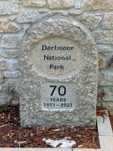
Stone Type: |
Marker
Stone |
|
|
|
|
|
|
|
|
|
Grid Reference: |
SX/6464/7883 |
|
|
|
|
|
|
|
|
|
Location: |
Against
the wall of the DNP Information Centre at Postbridge. |
|
|
|
|
|
|
|
|
|
Inscription: |
Dartmoor
National Park / 70 Years / 1951 - 2021. |
|
|
|
|
|
|
|
|
|
|
|
|
|
|
|
|
|
|
|
|
|
|
|
|
|
|
|
|
|
|
|
|
|
|
|
|
|
|
|
|
|
|
|
|
|
|
|
|
|
|
|
|
|
|
|
|
|
|
|
|
|
|
|
|
|
|
|
|
|
|
|
|
|
|
|
|
|
|
|
|
|
|
|
|
|
|
|
|
|
|
|
|
|
|
|
|
|
|
|
|
|
|
|
|
|
|
| |
|
|
|
|
|
|
|
|
|
|
|
|
|
|
|
|
|
|
|
|
|
|
|
|
|
|
|
|
|
|
|
|
|
|
|
|
|
|
|