| |
|
|
|
|
|
|
|
|
|
|
|
|
| |
|
|
|
|
|
|
|
|
|
|
|
|
|
|
|
|
|
|
|
|
District: |
West
Devon |
|
|
|
|
|
|
|
|
|
|
|
 |
|
| |
|
|
|
|
|
|
|
|
|
|
|
|
|
|
|
|
|
|
Parish: |
Tavistock |
 |
 |
 |
|
|
|
|
| |
|
|
|
|
|
|
|
|
|
|
|
|
|
|
|
|
|
|
|
| |
|
|
|
|
|
|
|
|
|
|
|
|
|
|
|
|
|
|
|
| |
|
|
|
|
|
|
|
|
|
|
|
|
|
|
|
|
|
|
|
| Page
Contents: |
|
|
22 Boundary Stones |
|
4 Crosses |
|
3
Guidestones |
|
9
Marker Stones |
|
7
Milestones |
|
|
|
|
|
|
|
|
|
|
|
|
|
|
|
|
|
|
|
|
|
| |
|
|
|
|
|
|
|
|
|
|
|
|
|
| |
|
|
|
|
|
|
|
|
|
|
|
|
| |
|
|
|
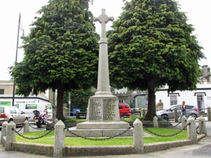
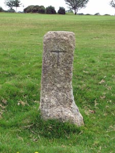
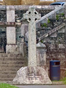
Stone Type: |
Tavistock
Town Cross |
| |
|
|
|
Grid Reference: |
SX/4821/7438 |
| |
|
|
|
Location: |
On
the grass at Bedford Square, Tavistock. |
| |
|
|
|
Notes: |
The
cross serves as the town's war memorial. |
| |
|
|
|
|
|
|
|
|
|
|
|
|
|
|
|
|
|
|
|
|
|
|
| |
|
|
|
|
|
|
|
|
|
|
|
|
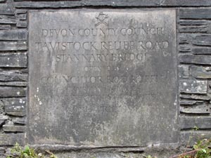
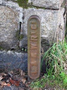
Stone Type: |
Road
Marker Stone |
|
|
|
|
|
|
|
|
Grid Reference: |
SX/4860/7457 |
|
|
|
|
|
|
|
|
Location: |
Built
into the corner of the wall leading to Stannary Bridge. |
|
|
|
|
|
|
|
|
Inscription: |
Tavistock
Relief Road - Stannary Bridge |
|
|
|
|
|
|
|
|
Notes: |
The
Relief Road was opened on 29th April 1995. |
|
|
|
|
|
|
|
|
|
|
|
|
|
|
|
|
|
|
|
|
|
|
|
|
|
|
|
|
|
|
|
|
|
|
|
|
|
|
|
|
|
|
|
|
|
|
|
|
|
|
|
|
|
|
|
|
|
|
|
|
|
Stone Type: |
Bridge
Marker Stone |
|
|
|
|
|
|
|
|
|
Grid Reference: |
SX/4842/7460 |
|
|
|
|
|
|
|
|
|
Location: |
Keystone
on the outside of the north east parapet of Vigo Bridge. |
|
|
|
|
|
|
|
|
|
Inscription: |
1
7 7 3 |
|
|
|
|
|
|
|
|
|
|
|
|
|
|
|
|
|
|
|
|
|
|
|
|
|
|
|
|
|
|
|
|
|
|
|
|
|
|
|
|
|
|
|
|
|
|
|
|
|
|
|
|
|
|
|
|
|
|
|
|
|
|
|
|
|
|
|
|
|
|
|
|
|
|
|
|
|
|
|
|
|
|
|
|
|
|
|
|
|
|
|
|
|
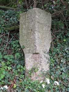
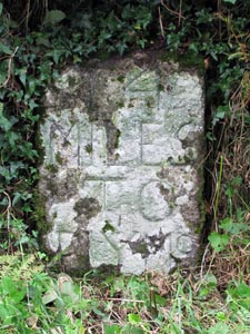
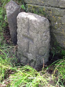
Stone Type: |
Section
of Cross Shaft |
|
|
|
|
|
|
|
|
|
Grid Reference: |
SX/4823/7429 |
|
|
|
|
|
|
|
|
|
Location: |
Just
inside the entrance to St. John's Avenue, which runs beside the river. |
|
|
|
|
|
|
|
|
|
Notes: |
It
is not known where this cross would have stood, before it was
mutilated. It now has a gate hasp fixed to the top of it. |
|
|
|
|
|
|
|
|
|
|
|
|
|
|
|
|
|
|
|
|
|
|
|
|
|
|
|
|
|
|
|
|
|
|
|
|
|
|
|
|
|
|
|
|
|
|
|
|
|
|
|
|
|
|
|
|
|
|
|
|
|
|
|
|
|
|
|
|
|
|
|
|
|
|
|
|
|
|
|
|
|
|
|
|
|
|
|
|
|
|
|
|
|
|
|
|
|
|
|
|
|
|
|
|
|
|
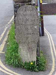
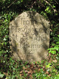
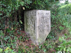
Stone Type: |
Milestone |
|
|
|
|
|
|
|
|
Grid Reference: |
SX/4817/7457 |
|
|
|
|
|
|
|
|
Location: |
At
the end of a wall, at the western end of Old Exeter Road. |
|
|
|
|
|
|
|
|
Inscription: |
From London 215 Miles / Okehampton 15 / Callington 9 / Truro 50 |
|
|
|
|
|
|
|
|
|
|
|
|
|
|
|
|
|
|
|
|
|
|
|
|
|
|
|
|
|
|
|
|
|
|
|
|
|
|
|
|
|
|
|
|
|
|
|
|
|
|
|
|
|
|
|
|
|
|
|
|
|
|
|
|
|
|
|
|
|
|
|
|
|
|
|
|
|
|
|
|
|
|
|
|
|
|
|
|
|
|
|
|
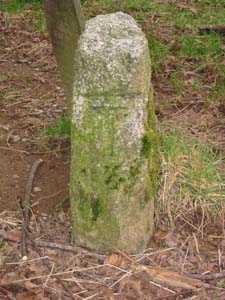
Stone Type: |
Boundary
Stone |
|
|
|
|
|
|
|
|
|
Grid Reference: |
SX/4829/7441 |
|
|
|
|
|
|
|
|
|
Location: |
Built
into the graveyard wall, 7 metres from the gate. |
|
|
|
|
|
|
|
|
|
Inscription: |
C
- (County Bridge Stone - see note on Home Page) |
|
|
|
|
|
|
|
|
|
|
|
|
|
|
|
|
|
|
|
|
|
|
|
|
|
|
|
|
|
|
|
|
|
|
|
|
|
|
|
|
|
|
|
|
|
|
|
|
|
|
|
|
|
|
|
|
|
|
|
|
|
|
|
|
|
|
|
|
|
|
|
|
|
|
|
|
|
|
|
|
|
|
|
|
|
|
|
|
|
|
|
|
|
|
|
|
|
|
|
|
|
|
|
|
|
|
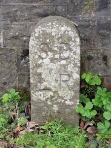
Stone Type: |
Boundary
Stone |
|
|
|
|
|
|
|
|
Grid Reference: |
SX/4858/7456 |
|
|
|
|
|
|
|
|
Location: |
Against
the wall at the junction of the A386 with the B3357 |
|
|
|
|
|
|
|
|
Inscription: |
S
D L R (South Devon & Launceston Railway) |
|
|
|
|
|
|
|
|
|
(Thanks
to Mark Fenlon for interpreting the Initials) |
|
|
|
|
|
|
|
|
|
|
|
|
|
|
|
|
|
|
|
|
|
|
|
|
|
|
|
|
|
|
|
|
|
|
|
|
|
|
|
|
|
|
|
|
|
|
|
|
|
|
|
|
|
|
|
|
|
|
|
|
|
|
|
|
|
|
|
|
|
|
|
|
|
|
|
|
|
|
|
|
|
|
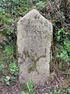
Stone Type: |
Guidestone |
|
|
|
|
|
|
|
|
|
Grid Reference: |
SX/4943/7474 |
|
|
|
|
|
|
|
|
|
Location: |
Set
back in the hedge of the junction of the B3357 with a minor road. |
|
|
|
|
|
|
|
|
|
Inscription: |
To Peter Tavy / To Moretonhampstead |
|
|
|
|
|
|
|
|
|
|
|
|
|
|
|
|
|
|
|
|
|
|
|
|
|
|
|
|
|
|
|
|
|
|
|
|
|
|
|
|
|
|
|
|
|
|
|
|
|
|
|
|
|
|
|
|
|
|
|
|
|
|
|
|
|
|
|
|
|
|
|
|
|
|
|
|
|
|
|
|
|
|
|
|
|
|
|
|
|
|
|
|
|
|
|
|
|
|
|
|
|
|
|
|
|
|
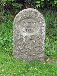
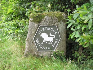
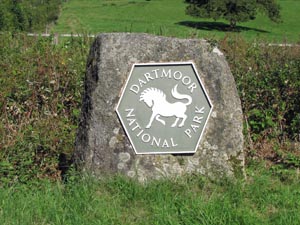
Stone Type: |
Boundary
Stone |
|
|
|
|
|
|
|
|
Grid Reference: |
SX/4968/7468 |
|
|
|
|
|
|
|
|
Location: |
On
the south side of the B3357, beside the entrance to a private property. |
|
|
|
|
|
|
|
|
Inscription: |
Dartmoor
National Park |
|
|
|
|
|
|
|
|
Notes: |
Marks
the boundary of the National Park. |
|
|
|
|
|
|
|
|
|
|
|
|
|
|
|
|
|
|
|
|
|
|
|
|
|
|
|
|
|
|
|
|
|
|
|
|
|
|
|
|
|
|
|
|
|
|
|
|
|
|
|
|
|
|
|
|
|
|
|
|
|
|
|
|
|
|
|
|
|
|
|
|
|
|
|
|
|
|
|
|
|
|
Stone Type: |
Milestone |
|
|
|
|
|
|
|
|
|
Grid Reference: |
SX/4996/7462 |
|
|
|
|
|
|
|
|
|
Location: |
Beside
the B3357, 10 metres below the Tavistock Town sign. |
|
|
|
|
|
|
|
|
|
Inscription: |
Truro 51 Miles / Moretonhampstead 19 |
|
|
|
|
|
|
|
|
|
|
|
|
|
|
|
|
|
|
|
|
|
|
|
|
|
|
|
|
|
|
|
|
|
|
|
|
|
|
|
|
|
|
|
|
|
|
|
|
|
|
|
|
|
|
|
|
|
|
|
|
|
|
|
|
|
|
|
|
|
|
|
|
|
|
|
|
|
|
|
|
|
|
|
|
|
|
|
|
|
|
|
|
|
|
|
|
|
|
|
|
|
|
|
|
|
|
Stone Type: |
Millennium Boundary Stone |
|
|
|
|
|
|
|
|
Grid Reference: |
SX/4984/7290 |
|
|
|
|
|
|
|
|
Location: |
Set in an area of grass in the centre of Middlemoor, on the outskirts of
Whitchurch. |
|
|
|
|
|
|
|
|
Inscription: |
T / MM / W (Tavistock / Millennium / Whitchurch). |
|
|
|
|
|
|
|
|
|
|
|
|
|
|
|
|
|
|
|
|
|
|
|
|
|
|
|
|
|
|
|
|
|
|
|
|
|
|
|
|
|
|
|
|
|
|
|
|
|
|
|
|
|
|
|
|
|
|
|
|
|
|
|
|
|
|
|
|
|
|
|
|
|
|
|
|
|
|
|
|
|
|
|
|
|
|
|
|
|
|
|
|
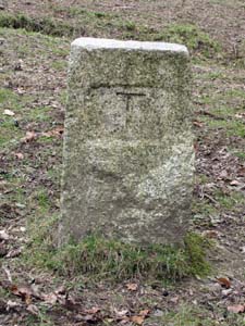
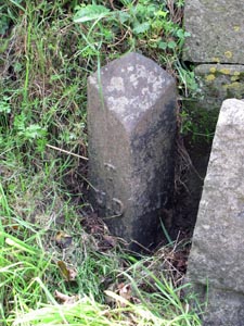
Stone Type: |
Boundary Stone |
|
|
|
|
|
|
|
|
|
Grid Reference: |
SX/4954/7371 |
|
|
|
|
|
|
|
|
|
Location: |
On the north verge of the road that runs across Whitchurch Down |
|
|
|
|
|
|
|
|
|
Inscription: |
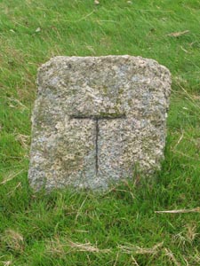
T (Tavistock). |
|
|
|
|
|
|
|
|
| Notes: |
See
below the entry down the page for the metal spike. |
|
|
|
|
|
|
|
|
|
|
|
|
|
|
|
|
|
|
|
|
|
|
|
|
|
|
|
|
|
|
|
|
|
|
|
|
|
|
|
|
|
|
|
|
|
|
|
|
|
|
|
|
|
|
|
|
|
|
|
|
|
|
|
|
|
|
|
|
|
|
|
|
|
|
|
|
|
|
|
|
|
|
|
|
|
|
|
|
|
|
|
|
|
|
|
|
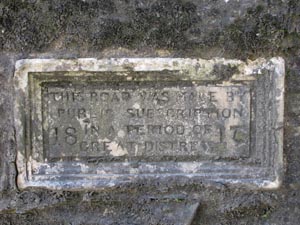
Stone Type: |
Road
Marker Stone |
|
|
|
|
|
|
|
Grid Reference: |
SX/4924/7524 |
|
|
|
|
|
|
|
Location: |
Built
into the eastern roadside wall of the A386 |
|
|
|
|
|
|
|
Inscription: |
This Road was made by Public Subscription in a Period of Great Distress 1817 |
|
|
|
|
|
|
|
|
|
|
|
|
|
|
|
|
|
|
|
|
|
|
|
|
|
|
|
|
|
|
|
|
|
|
|
|
|
|
|
|
|
|
|
|
|
|
|
|
|
|
|
|
|
|
|
Stone Type: |
Milestone |
|
|
|
|
|
|
|
|
|
Grid Reference: |
SX/4928/7548 |
|
|
|
|
|
|
|
|
|
Location: |
On
the eastern verge of the A386, close to a junction with a minor road. |
|
|
|
|
|
|
|
|
|
Inscription: |
From Tavistock 1 Mile / Oakhampton 14 / Truro 51 |
|
|
|
|
|
|
|
|
|
|
|
|
|
|
|
|
|
|
|
|
|
|
|
|
|
|
|
|
|
|
|
|
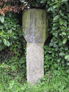
Stone Type: |
Hurdwick (Wayside) Cross |
|
|
|
|
|
Grid Reference: |
SX/4718/7584 |
|
|
|
|
|
Location: |
Set on the corner of the garden wall in the drive to Hurdwick Farm,
Tavistock. |
|
|
|
|
|
|
|
|
Notes: |
The cross was probably once a marker on the route to Tavistock Abbey. |
|
|
|
|
|
|
|
|
|
|
|
|
|
|
|
|
|
|
|
|
|
|
|
|
|
|
|
|
|
|
|
|
|
|
|
|
|
|
|
|
|
|
|
|
|
|
|
|
|
|
|
|
|
|
|
|
|
|
|
|
|
|
|
|
|
|
|
|
|
|
|
|
|
|
|
|
|
|
|
|
|
|
|
|
|
|
|
|
|
|
|
|
Stone Type: |
Hurdwick Farm Take-off Marker Stone |
|
|
|
|
|
|
|
|
|
Grid Reference: |
SX/471/758 |
|
|
|
|
|
|
|
|
|
Location: |
Set up against the garden wall of Hurdwick Farm, Tavistock |
|
|
|
|
|
|
|
|
|
Inscription: |
Take Off |
|
|
|
|
|
|
|
|
| Notes: |
This Turnpike stone would have marked the point on the hill out of Tavistock
where any additional horses would have to be unhitched. |
|
|
|
|
|
|
|
|
|
|
|
|
|
|
|
|
|
|
|
|
|
|
|
|
|
|
|
|
|
|
|
|
|
|
|
|
|
|
|
|
|
|
|
|
|
|
|
|
|
|
|
|
|
|
|
|
|
|
|
|
|
|
|
|
|
|
|
|
|
|
|
|
|
|
|
|
|
|
|
|
|
|
|
|
|
|
|
|
|
|
|
|
|
|
|
|
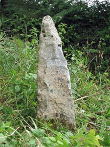
Stone Type: |
Boundary Stone |
|
|
|
|
|
|
|
|
Grid Reference: |
SX/4711/7583 |
|
|
|
|
|
|
|
|
Location: |
This stone is on private property in a field next to Hurdwick Farm, close to
the hedge. |
|
|
|
|
|
|
|
|
Inscription: |
T (Tavistock) |
|
|
|
|
|
|
|
|
|
|
|
|
|
|
|
|
|
|
|
|
|
|
|
|
|
|
|
|
|
|
|
|
|
|
|
|
|
|
|
|
|
|
|
|
|
|
|
|
|
|
|
|
|
|
|
|
|
|
|
|
|
|
|
|
|
|
|
|
|
|
|
|
|
|
|
|
|
|
|
|
|
|
|
|
|
|
|
|
|
|
|
|
Stone Type: |
Guidestone |
|
|
|
|
|
|
|
|
|
Grid Reference: |
SX/4682/7341 |
|
|
|
|
|
|
|
|
|
Location: |
Set
well back on the south east verge of the A390. |
|
|
|
|
|
|
|
|
|
Inscription: |
Beer Alstone and Gawton Quay / Callington / Morwelham & New Quay |
|
|
|
|
|
|
|
|
|
Notes: |
All
these Quays are to be found on the banks of the River Tamar. |
|
|
|
|
|
|
|
|
|
|
|
|
|
|
|
|
|
|
|
|
|
|
|
|
|
|
|
|
|
|
|
|
|
|
|
|
|
|
|
|
|
|
|
|
|
|
|
|
|
|
|
|
|
|
|
|
|
|
|
|
|
|
|
|
|
|
|
|
|
|
|
|
|
|
|
|
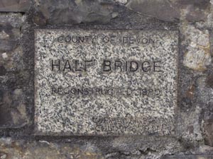
Stone Type: |
Bridge
Marker Stone |
|
|
|
|
|
|
|
Grid Reference: |
SX/5023/7667 |
|
|
|
|
|
|
|
Location: |
Built
into the south east parapet of Half Bridge |
|
|
|
|
|
|
|
Inscription: |
Half
Bridge Reconstructed 1980. |
|
|
|
|
|
|
|
|
|
|
|
|
|
|
|
|
|
|
|
|
|
|
|
|
|
|
|
|
|
|
|
|
|
|
|
|
|
|
|
|
|
|
|
|
|
|
|
|
|
|
|
|
|
|
|
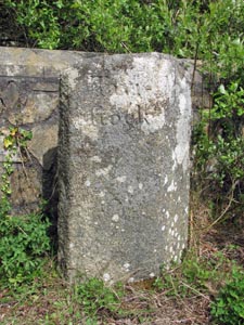
Stone Type: |
Boundary
Stone |
|
|
|
|
|
|
|
|
|
Grid Reference: |
SX/5022/7669 |
|
|
|
|
|
|
|
|
|
Location: |
Standing
against the north west parapet of Half Bridge. |
|
|
|
|
|
|
|
|
|
Inscription: |
Tavistock
/ Mary Tavy |
|
|
|
|
|
|
|
|
|
|
|
|
|
|
|
|
|
|
|
|
|
|
|
|
|
|
|
|
|
|
|
|
|
|
|
|
|
|
|
|
|
|
|
|
|
|
|
|
|
|
|
|
|
|
|
|
|
|
|
|
|
|
|
|
|
|
|
|
|
|
|
|
|
|
|
|
|
|
|
|
|
|
|
|
|
|
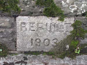
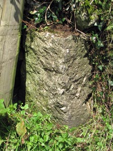
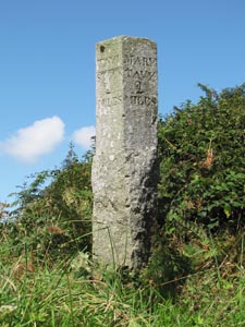
Stone Type: |
Bridge
Marker Stone |
|
|
|
|
|
|
|
Grid Reference: |
SX/4758/7388 |
|
|
|
|
|
|
|
Location: |
Set
in the north-east parapet of the bridge over the River Tavy. |
|
|
|
|
|
|
|
Inscription: |
Rebuilt
1903 |
|
|
|
|
|
|
|
|
|
|
|
|
|
|
|
|
|
|
|
|
|
|
|
|
|
|
|
|
|
|
|
|
|
|
|
|
|
|
|
|
|
|
|
|
|
|
|
|
|
|
|
|
|
|
|
Stone Type: |
Milestone |
|
|
|
|
|
|
|
|
|
Grid Reference: |
SX/4918/7401 |
|
|
|
|
|
|
|
|
|
Location: |
High
on the Bank on the north-east verge of the road. |
|
|
|
|
|
|
|
|
|
Inscription: |
14
Miles To Plymo (Plymouth) |
|
|
|
|
|
|
|
|
| Notes: |
The
northern edge is inscribed '1 T' (1 Mile to Tavistock). |
|
|
|
|
|
|
|
|
|
|
|
|
|
|
|
|
|
|
|
|
|
|
|
|
|
|
|
|
|
|
|
|
|
|
|
|
|
|
|
|
|
|
|
|
|
|
|
|
|
|
|
|
|
|
|
|
|
|
|
|
|
|
|
|
|
|
|
|
|
|
|
|
|
|
|
|
|
|
|
|
|
|
|
|
|
|
|
|
|
|
|
|
|
|
|
|
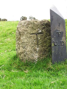
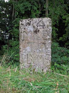
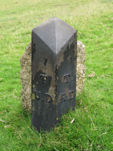
Stone Type: |
Boundary
Iron |
|
|
|
|
|
|
|
|
Grid Reference: |
SX/4954/7371 |
|
|
|
|
|
|
|
|
Location: |
On the north verge of the road that runs across Whitchurch Down |
|
|
|
|
|
|
|
|
Inscription: |
T
U D / T R D (Tavistock Urban/Rural District) |
|
|
|
|
|
|
|
|
Notes |
See
entry higher up the page for the adjacent Boundary Stone. |
|
|
|
|
|
|
|
|
|
|
|
|
|
|
|
|
|
|
|
|
|
|
|
|
|
|
|
|
|
|
|
|
|
|
|
|
|
|
|
|
|
|
|
|
|
|
|
|
|
|
|
|
|
|
|
|
|
|
|
|
|
|
|
|
|
|
|
|
|
|
|
|
|
|
|
|
|
|
|
|
|
|
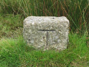
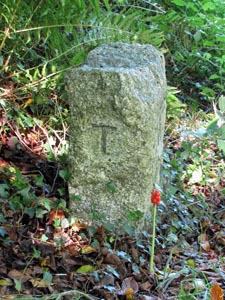
Stone Type: |
Boundary
Stone |
|
|
|
|
|
|
|
|
|
Grid Reference: |
SX/4984/7378 |
|
|
|
|
|
|
|
|
|
Location: |
To
the north of the road that runs across Whitchurch Down. |
|
|
|
|
|
|
|
|
|
Inscription: |
T
(Tavistock) |
|
|
|
|
|
|
|
|
| Notes: |
Shares
its boundary with Whitchurch |
|
|
|
|
|
|
|
|
|
|
|
|
|
|
|
|
|
|
|
|
|
|
|
|
|
|
|
|
|
|
|
|
|
|
|
|
|
|
|
|
|
|
|
|
|
|
|
|
|
|
|
|
|
|
|
|
|
|
|
|
|
|
|
|
|
|
|
|
|
|
|
|
|
|
|
|
|
|
|
|
|
|
|
|
|
|
|
|
|
|
|
|
|
|
|
|
Stone Type: |
Boundary
Stone |
|
|
|
|
|
|
|
|
Grid Reference: |
SX/5010/7383 |
|
|
|
|
|
|
|
|
Location: |
Near
the 7th Tee of the Golf Course on Whitchurch Down. |
|
|
|
|
|
|
|
|
Inscription: |
T
(Tavistock) |
|
|
|
|
|
|
|
|
Notes |
Shares
its boundary with Whitchurch |
|
|
|
|
|
|
|
|
|
|
|
|
|
|
|
|
|
|
|
|
|
|
|
|
|
|
|
|
|
|
|
|
|
|
|
|
|
|
|
|
|
|
|
|
|
|
|
|
|
|
|
|
|
|
|
|
|
|
|
|
|
|
|
Stone Type: |
Boundary
Stone |
|
|
|
|
|
|
|
|
Grid Reference: |
SX/5035/7388 |
|
|
|
|
|
|
|
|
Location: |
On
a small mound, 8 yards west of the unclassified road. |
|
|
|
|
|
|
|
|
Inscription: |
T
(Tavistock) |
|
|
|
|
|
|
|
| Notes: |
Shares
its boundary with Whitchurch |
|
|
|
|
|
|
|
|
|
|
|
|
|
|
|
|
|
|
|
|
|
|
|
|
|
|
|
|
|
|
|
|
|
|
|
|
|
|
|
Stone Type: |
Boundary
Stone |
|
|
|
|
|
|
|
Grid Reference: |
SX/5115/7459 |
|
|
|
|
|
|
|
Location: |
On
the southern verge of the B3357, 40 yards west of the road junction. |
|
|
|
|
|
|
|
Inscription: |
Dartmoor
National Park |
|
|
|
|
|
|
|
Notes: |
Marks
the boundary of the National Park. |
|
|
|
|
|
|
|
|
|
|
|
|
|
|
|
|
|
|
|
|
|
|
|
|
|
|
|
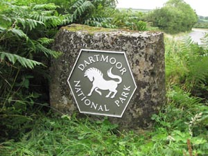
Stone Type: |
Boundary
Stone |
|
|
|
|
|
|
|
|
Grid Reference: |
SX/5115/7460 |
|
|
|
|
|
|
|
|
Location: |
On
the northern verge of the B3357, 40 yards west of the road junction. |
|
|
|
|
|
|
|
|
Inscription: |
Dartmoor
National Park |
|
|
|
|
|
|
|
| Notes: |
Marks
the boundary of the National Park. |
|
|
|
|
|
|
|
|
|
|
|
|
|
|
|
|
|
|
|
|
|
|
|
|
|
|
|
|
|
|
|
|
|
|
|
|
|
|
|
|
|
|
|
|
|
|
|
|
|
|
|
|
|
|
|
|
|
|
|
Stone Type: |
Milestone |
|
|
|
|
|
|
|
|
Grid Reference: |
SX/5125/7517 |
|
|
|
|
|
|
|
|
Location: |
Beside
the gate, opposite the entrance lane to Collaton. |
|
|
|
|
|
|
|
|
Inscription: |
14
Miles To Plymo (Plymouth) |
|
|
|
|
|
|
|
|
|
|
|
|
|
|
|
|
|
|
|
|
|
|
|
|
|
|
|
|
|
|
|
|
|
|
|
|
|
|
|
|
|
|
|
|
|
|
|
|
|
|
|
|
|
|
|
|
|
|
|
|
|
|
|
|
|
|
|
|
|
|
|
|
|
|
|
|
|
|
|
|
|
|
|
|
|
|
|
|
|
|
|
|
Stone Type: |
Boundary
Stone |
|
|
|
|
|
|
|
|
|
Grid Reference: |
SX/5125/7518 |
|
|
|
|
|
|
|
|
|
Location: |
On
the grass verge at the entrance to Collaton. |
|
|
|
|
|
|
|
|
|
Inscription: |
T
(Tavistock) |
|
|
|
|
|
|
|
|
| Notes: |
Shares
its boundary with Peter Tavy and Whitchurch. |
|
|
|
|
|
|
|
|
|
|
|
|
|
|
|
|
|
|
|
|
|
|
|
|
|
|
|
|
|
|
|
|
|
|
|
|
|
|
|
|
|
|
|
|
|
|
|
|
|
|
|
|
|
|
|
|
|
|
|
|
|
|
|
|
|
|
|
|
|
|
|
|
|
|
|
|
|
|
|
|
|
|
|
|
|
|
|
|
|
|
|
|
|
|
|
|
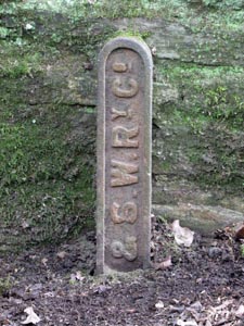
Stone Type: |
Boundary
Marker |
|
|
|
|
|
|
|
|
Grid Reference: |
SX/4722/7387 |
|
|
|
|
|
|
|
|
Location: |
Against
the house wall on the south side of the unclassified road. |
|
|
|
|
|
|
|
|
Inscription: |
L.
& S. W. Ry Co. (London & South Western Railway Company) |
|
|
|
|
|
|
|
|
Notes: |
The
"L" is buried beneath the road surface. |
|
|
|
|
|
|
|
|
|
|
|
|
|
|
|
|
|
|
|
|
|
|
|
|
|
|
|
|
|
|
|
|
|
|
|
|
|
|
|
|
|
|
|
|
|
|
|
|
|
|
|
|
|
|
|
|
|
|
|
|
|
|
|
|
|
|
|
|
|
|
|
|
|
|
|
|
|
|
|
|
|
|
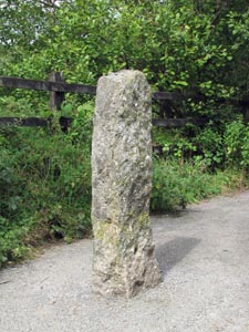
Stone Type: |
Marker
Stone |
|
|
|
|
|
|
|
|
|
Grid Reference: |
SX/4716/7388 |
|
|
|
|
|
|
|
|
|
Location: |
At
the south western end of the Tavistock Viaduct Walk |
|
|
|
|
|
|
|
|
|
Notes: |
This
plain granite pillar marks the end of the Viaduct Walk. |
|
|
|
|
|
|
|
|
|
|
|
|
|
|
|
|
|
|
|
|
|
|
|
|
|
|
|
|
|
|
|
|
|
|
|
|
|
|
|
|
|
|
|
|
|
|
|
|
|
|
|
|
|
|
|
|
|
|
|
|
|
|
|
|
|
|
|
|
|
|
|
|
|
|
|
|
|
|
|
|
|
|
|
|
|
|
Stone Type: |
Guide
Stone |
|
|
|
|
|
|
|
Grid Reference: |
SX/4710/7479 |
|
|
|
|
|
|
|
Location: |
At
the B3362 junction with the unclassified road to Millhill. |
|
|
|
|
|
|
|
Inscription: |
Millhill
and Chipshop / Milton Abbot and Launceston. |
|
|
|
|
|
|
|
|
|
|
|
|
|
|
|
|
|
|
|
|
|
|
|
|
|
|
|
|
|
|
|
|
|
|
|
|
|
|
|
|
|
|
|
|
|
|
|
|
|
|
|
|
|
|
|
Stone Type: |
Boundary
Marker |
|
|
|
|
|
|
|
|
|
Grid Reference: |
SX/4785/7455 |
|
|
|
|
|
|
|
|
|
Location: |
Against
the northern end of the western parapet of the bridge. |
|
|
|
|
|
|
|
|
|
Inscription: |
L.
& S. W. Ry Co. (London & South Western Railway Company) |
|
|
|
|
|
|
|
|
|
|
|
|
|
|
|
|
|
|
|
|
|
|
|
|
|
|
|
|
|
|
|
|
|
|
|
|
|
|
|
|
|
|
|
|
|
|
|
|
|
|
|
|
|
|
|
|
|
|
|
|
|
|
|
|
|
|
|
|
|
|
|
|
|
|
|
|
|
|
|
|
|
|
|
|
|
|
|
|
|
|
|
|
|
|
|
|
|
|
|
|
|
|
|
|
|
|
Stone Type: |
Milestone |
|
|
|
|
|
|
|
|
Grid Reference: |
SX4734/7582 |
|
|
|
|
|
|
|
|
Location: |
Against
the left-hand wall of the entrance to Hurdwick Farm. |
|
|
|
|
|
|
|
|
Inscription: |
1
T (1 Mile toTavistock) / 16 O (16 Miles to Okehampton). |
|
|
|
|
|
|
|
|
Notes: |
There
is also a date inscribed on the main face, but this is now illegible due
to it being mostly sunken into the ground. |
|
|
|
|
|
|
|
|
|
|
|
|
|
|
|
|
|
|
|
|
|
|
|
|
|
|
|
|
|
|
|
|
|
|
|
|
|
|
|
|
|
|
|
|
|
|
|
|
|
|
|
|
|
|
|
|
|
|
|
|
|
|
|
|
|
|
|
|
|
|
|
|
|
|
|
Stone Type: |
Boundary
Iron |
|
|
|
|
|
|
|
|
|
Grid Reference: |
SX/4734/7582 |
|
|
|
|
|
|
|
|
|
Location: |
Against
the left-hand wall of the entrance to Hurdwick Farm. |
|
|
|
|
|
|
|
|
|
Inscription: |
T
U D / T R D (Tavistock Urban/Rural District) |
|
|
|
|
|
|
|
|
| Notes: |
This
Boundary marker sits adjacent to the above Milestone. |
|
|
|
|
|
|
|
|
|
|
|
|
|
|
|
|
|
|
|
|
|
|
|
|
|
|
|
|
|
|
|
|
|
|
|
|
|
|
|
|
|
|
|
|
|
|
|
|
|
|
|
|
|
|
|
|
|
|
|
|
|
|
|
|
|
|
|
|
|
|
|
|
|
|
|
|
|
|
|
|
|
|
|
|
|
|
|
|
|
|
|
|
|
|
|
|
Stone Type: |
Boundary
Stone |
|
|
|
|
|
|
|
|
Grid Reference: |
SX/4726/7727 |
|
|
|
|
|
|
|
|
Location: |
On
the western side of the unclassified road, adjacent to a field gate. |
|
|
|
|
|
|
|
|
Inscription: |
Tavi
/ Stock / Lam / Erton |
|
|
|
|
|
|
|
|
Notes: |
The
inscription is no longer visible. |
|
|
|
|
|
|
|
|
|
|
|
|
|
|
|
|
|
|
|
|
|
|
|
|
|
|
|
|
|
|
|
|
|
|
|
|
|
|
|
|
|
|
|
|
|
|
|
|
|
|
|
|
|
|
|
|
|
|
|
|
|
|
|
|
|
|
|
|
|
|
|
|
|
|
|
|
|
|
|
|
|
|
Stone Type: |
Milestone |
|
|
|
|
|
|
|
|
|
Grid Reference: |
SX/4899/7779 |
|
|
|
|
|
|
|
|
|
Location: |
On
the grass verge at the junction of two unclassified roads. |
|
|
|
|
|
|
|
|
|
Inscription: |
Lamerton
3 Miles / Tavistock 2 Miles / Mary Tavy 2 Miles. |
|
|
|
|
|
|
|
|
|
|
|
|
|
|
|
|
|
|
|
|
|
|
|
|
|
|
|
|
|
|
|
|
|
|
|
|
|
|
|
|
|
|
|
|
|
|
|
|
|
|
|
|
|
|
|
|
|
|
|
|
|
|
|
|
|
|
|
|
|
|
|
|
|
|
|
|
|
|
|
|
|
|
|
|
|
|
|
|
|
|
|
|
|
|
|
|
|
|
|
|
|
|
|
|
|
|
Stone Type: |
Millennium
Boundary Stone |
|
|
|
|
|
|
|
|
Grid Reference: |
SX/4905/7757 |
|
|
|
|
|
|
|
|
Location: |
On
the grass verge, just to the south of the farm entrance. |
|
|
|
|
|
|
|
|
Inscription: |
T
(Tavistock) |
|
|
|
|
|
|
|
|
Notes: |
This
stone also marks the border of the Parishes of Lamerton and Mary Tavy. |
|
|
|
|
|
|
|
|
|
|
|
|
|
|
|
|
|
|
|
|
|
|
|
|
|
|
|
|
|
|
|
|
|
|
|
|
|
|
|
|
|
|
|
|
|
|
|
|
|
|
|
|
|
|
|
|
|
|
|
|
|
|
|
Stone Type: |
Boundary
Stone |
|
|
|
|
|
|
|
|
Grid Reference: |
SX/4960/7602 |
|
|
|
|
|
|
|
|
Location: |
On
the north western verge of the A386, next to the unclassified road junction. |
|
|
|
|
|
|
|
|
Inscription: |
Dartmoor
National Park |
|
|
|
|
|
|
|
| Notes: |
Marks
the boundary of the National Park. |
|
|
|
|
|
|
|
|
|
|
|
|
|
|
|
|
|
|
|
|
|
|
|
|
|
|
|
|
|
|
|
|
|
|
|
|
|
|
|
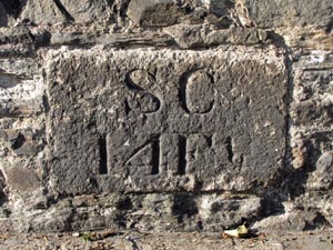
Stone Type: |
Marker
Stone |
|
|
|
|
|
|
|
Grid Reference: |
SX/4802/7429 |
|
|
|
|
|
|
|
Location: |
Built
into the base of the wall on the north west side of Plymouth Road,
Tavistock. |
|
|
|
|
|
|
|
Inscription: |
S
C 14 Ft (Stop Cock 14 Feet?) |
|
|
|
|
|
|
|
|
|
|
|
|
|
|
|
|
|
|
|
|
|
|
|
|
|
|
|
|
|
|
|
|
|
|
|
|
|
|
|
|
|
|
|
|
|
|
|
|
|
|
|
|
|
|
| Stone Type: |
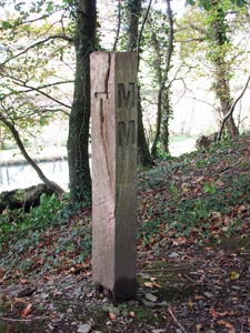
Wooden
Millennium Boundary Post |
|
|
|
|
|
|
|
|
| Grid Reference: |
SX/4689/7215 |
|
|
|
|
|
|
|
|
| Location: |
Beside
the tow path on the Tavistock Canal |
|
|
|
|
|
|
|
|
| Inscription: |
T
/ MM / G (Tavistock / Millennium / Gulworthy) |
|
|
|
|
|
|
|
|
|
|
|
|
|
|
|
|
|
|
|
|
|
|
|
|
|
|
|
|
|
|
|
|
|
|
|
|
|
|
|
|
|
|
|
|
|
|
|
|
|
|
|
|
|
|
|
|
|
|
|
|
|
|
|
|
|
|
|
|
|
|
|
|
|
|
|
|
|
|
|
|
|
|
|
|
|
|
|
|
|
|
|
|
|
|
|
|
|
|
|
|
|
|
|
|
|
|
Stone Type: |
Wooden
Millennium Boundary Post |
|
|
|
|
|
|
|
|
Grid Reference: |
SX/4661/7215 |
|
|
|
|
|
|
|
|
Location: |
Beside
the tow path on the Tavistock Canal |
|
|
|
|
|
|
|
|
Inscription: |
T
/ MM / G (Tavistock / Millennium / Gulworthy) |
|
|
|
|
|
|
|
|
|
|
|
|
|
|
|
|
|
|
|
|
|
|
|
|
|
|
|
|
|
|
|
|
|
|
|
|
|
|
|
|
|
|
|
|
|
|
|
|
|
|
|
|
|
|
|
|
|
|
|
|
|
|
|
|
|
|
|
|
|
|
|
|
|
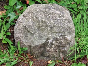
Stone Type: |
Marker
Stone |
|
|
|
|
|
|
|
|
Grid Reference: |
SX/4786/7415 |
|
|
|
|
|
|
|
|
Location: |
On
the southern verge of Plymouth Road, Tavistock. |
|
|
|
|
|
|
|
|
Inscription: |
M
H / 1 2 F (Man Hole 12 feet) |
|
|
|
|
|
|
|
| Notes: |
I'm
not sure whether the 'MH' represents 'Man Hole' or 'Mains Hydrant' but the
latest thinking is that it applies to the former. |
|
|
|
|
|
|
|
|
|
|
|
|
|
|
|
|
|
|
|
|
|
|
|
|
|
|
|
|
|
|
|
|
|
|
|
|
|
|
|
|
|
|
|
|
|
|
|
|
|
|
|
|
|
|
|
|
|
|
|
Stone Type: |
War
Memorial Cross |
|
|
|
|
|
|
|
|
Grid Reference: |
SX/4891/7511 |
|
|
|
|
|
|
|
|
Location: |
At
the foot of the steps, in front of the main building of Mount Kelly
School. |
|
|
|
|
|
|
|
|
Inscription: |
In
/ Proud and Loving Memory / of / Our Glorious Dead / 1914 - 1918 / 1939 -
1945 |
|
|
|
|
|
|
|
|
Notes: |
Please
note that the cross stands on private land. For more information on this
cross, see dartmoor-crosses.org.uk |
|
|
|
|
|
|
|
|
|
|
|
|
|
|
|
|
|
|
|
|
|
|
|
|
|
|
|
|
|
|
|
|
|
|
|
|
|
|
|
|
|
|
|
|
|
|
|
|
|
|
|
|
|
|
|
|
|
|
|
|
|
|
|
|
|
|
|
|
|
|
|
|
|
|
|
|
|
|
|
|
|
|
|
|
|
|
|
|
| |
|
|
|
|
|
|
|
|
|
|
|
|
|
|
|
|
|
|
|
|
|
|
|
|
|
|
|
|
|
|
|
|
|
|
|
|
|
|
|