 Location:
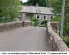
Built into the centre of the North West parapet of the bridge over
the river Walkham, which runs through the centre of the village. Location:
Built into the centre of the North West parapet of the bridge over
the river Walkham, which runs through the centre of the village.
O/S Grid Ref: SX/51331/69933
Longitude/Latitude (Degrees+/-): -4.09810/50.51026
Map location: Click here
to view map.
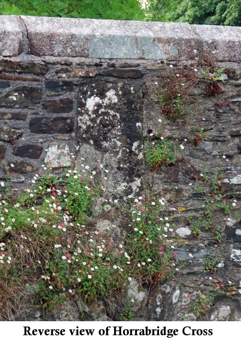
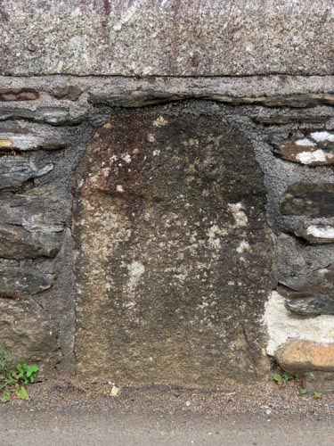
Purpose: Ancient
boundary marker.
Size: Roadside,
the stone measures 2 feet (0.60 metres) tall by 1 foot 4 inches (0.40
metres) wide. On the riverside face, it measures 3 feet (0.90 metres) tall
by 1 foot 4 inches (0.40 metres) wide. The incised cross is on the
roadside only and this measures 1 foot 11 inches (0.60 metres) tall and 1
foot (0.30 metres) across the arms.
 Information:
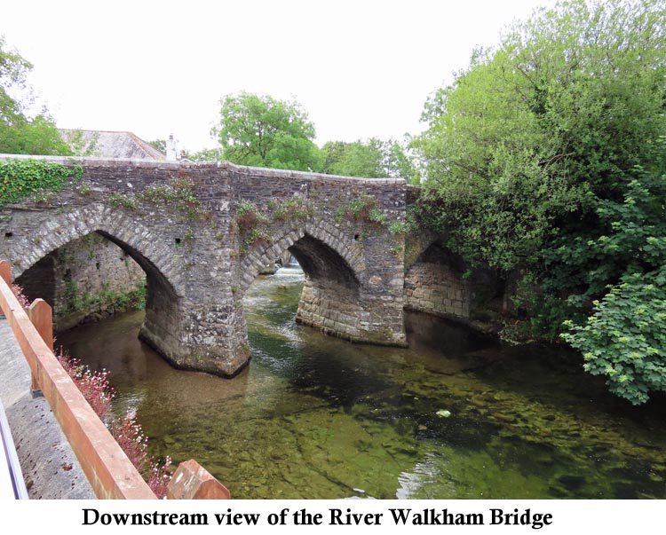
The River Walkham flows through the
centre of Horrabridge and passes beneath the ancient packhorse bridge,
before merging with the River Tavy about 3 miles to the west of the
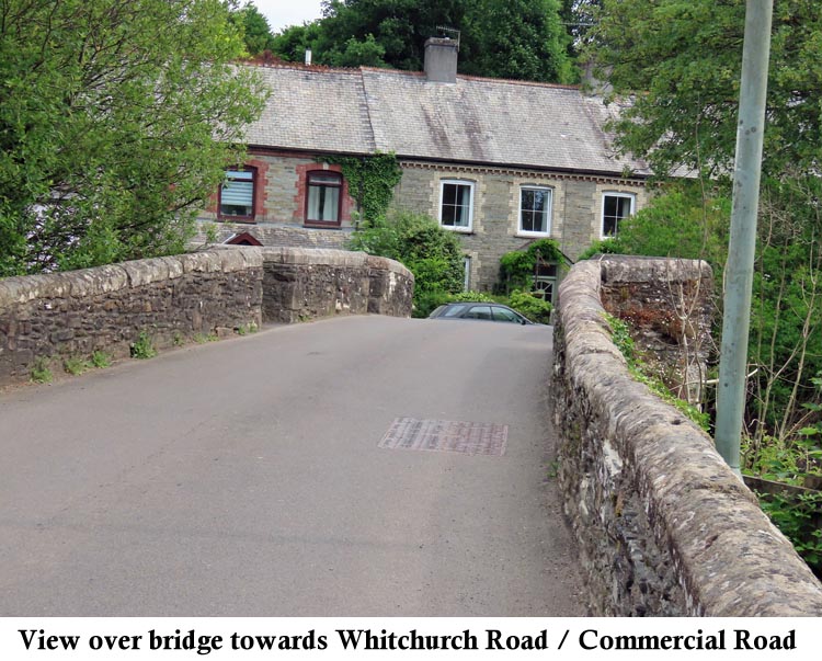
village. In the village, the bridge stands at the northern end of
Station Road, right next to its junction with both Commercial Road and
Whitchurch Road. It is a narrow bridge
with two ‘V’ shaped pedestrian refuges built into the parapet, to allow
pedestrians to stand aside for cars to pass. Only one vehicle Information:
The River Walkham flows through the
centre of Horrabridge and passes beneath the ancient packhorse bridge,
before merging with the River Tavy about 3 miles to the west of the
village. In the village, the bridge stands at the northern end of
Station Road, right next to its junction with both Commercial Road and
Whitchurch Road. It is a narrow bridge
with two ‘V’ shaped pedestrian refuges built into the parapet, to allow
pedestrians to stand aside for cars to pass. Only one vehicle 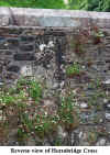 at a time
can cross the bridge and it can get quite busy with cars waiting to cross
from three different directions. It is thought that the bridge was built
in the 14th century, which would make it one of the oldest in
Devon that is still open to traffic. at a time
can cross the bridge and it can get quite busy with cars waiting to cross
from three different directions. It is thought that the bridge was built
in the 14th century, which would make it one of the oldest in
Devon that is still open to traffic.
The site of this cross, built into the north west
(downstream) parapet
of the bridge over the centre of the river, is on the exact boundary of three
ancient parishes: Buckland Monachorum, Whitchurch and Sandford Spiney.
According to the Western Antiquary, December 1882, the stone once had the
letters 'B' and 'W' incised into opposing faces, marking the boundary of
two of these parishes. However, all trace of these letters has now
disappeared, to be replaced by an incised cross on the roadside face
which, in 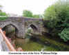 itself, has now become very
faint. The
depth of the stone goes right the way through the wall and looking from
the road it appears to extend down to well below the level of the current road
surface. itself, has now become very
faint. The
depth of the stone goes right the way through the wall and looking from
the road it appears to extend down to well below the level of the current road
surface.
 Horrabridge is a busy
and vibrant village. Upstream from the bridge, there is a salmon leap.
This has given its name to the nearby Public House, the ‘Leaping Salmon’
and also to a private house, which goes by the name of ‘Salmon Leap’.
Downstream, there is a pool in the river, below a weir, where the children
often swim and play during the hot summer months. Beyond each end of
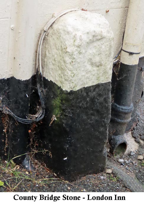
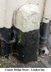
the bridge, County Boundary Stones are still in position. The one in
Station Road is placed against the wall of the London Inn and is partly
hidden behind the street lamppost. Unfortunately, this stone has now
been painted over, in the same colours as the adjacent wall of the
inn. The second stone is in Commercial Road and stands beside a
telegraph pole, opposite the junction with Bedford Road. These
stones would have been erected when the Turnpike
Trusts came into being, during the 18th Century. The main function
of the Trusts was
to maintain and improve the road structure, for which they were able to
charge a toll to all traffic passing through. However, the cost of
building and maintaining the bridges over major rivers remained the
responsibility of the County Council. The County were also
responsible for maintaining a stretch of the road for about 100 yards
beyond each end of the bridge. County Bridge Stones, which are
inscribed with a large 'C', were erected to mark the boundary between the responsibilities
of the County and the Turnpike Trusts. Horrabridge is a busy
and vibrant village. Upstream from the bridge, there is a salmon leap.
This has given its name to the nearby Public House, the ‘Leaping Salmon’
and also to a private house, which goes by the name of ‘Salmon Leap’.
Downstream, there is a pool in the river, below a weir, where the children
often swim and play during the hot summer months. Beyond each end of
the bridge, County Boundary Stones are still in position. The one in
Station Road is placed against the wall of the London Inn and is partly
hidden behind the street lamppost. Unfortunately, this stone has now
been painted over, in the same colours as the adjacent wall of the
inn. The second stone is in Commercial Road and stands beside a
telegraph pole, opposite the junction with Bedford Road. These
stones would have been erected when the Turnpike
Trusts came into being, during the 18th Century. The main function
of the Trusts was
to maintain and improve the road structure, for which they were able to
charge a toll to all traffic passing through. However, the cost of
building and maintaining the bridges over major rivers remained the
responsibility of the County Council. The County were also
responsible for maintaining a stretch of the road for about 100 yards
beyond each end of the bridge. County Bridge Stones, which are
inscribed with a large 'C', were erected to mark the boundary between the responsibilities
of the County and the Turnpike Trusts.
Our thanks to
Adrian for informing us about the Western Antiquary reference.
|