Browse crosses
![]()
![]()
![]()

|
Browse crosses |
|
 Location:
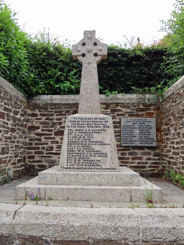
Built into the churchyard wall at the junction of the road leading down to
the centre of the village, from the direction of Walkhampton. Location:
Built into the churchyard wall at the junction of the road leading down to
the centre of the village, from the direction of Walkhampton.
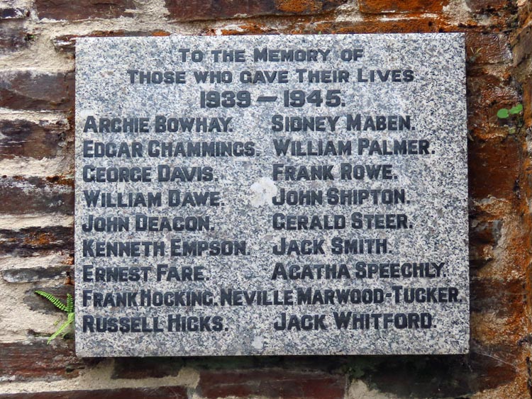
O/S Grid Ref: SX/51226/69696 Longitude/Latitude (Degrees+/-): -4.09948/50.50810 Map location: Click here to view map. Purpose: Memorial to all those in the village who lost their lives in both World Wars. Size: 4 feet 11 inches (1.50 metres) tall. 2 feet (0.60 metres) across the arms. Information: This cross is set back into the churchyard wall on a rounded corner at the junction of Walkhampton Road and Station Road. It is set up on a double plinth of stones. The shaft is set into a massive tapered granite stone for its socket. This is a modern cross of Celtic design.
For a village that has stood for several centuries, the church is relatively modern, having been built in 1893, with the porch being a later addition, completed in 1914. The church is dedicated to St John the Baptist and is thought to stand on the site of a former chapel of ease, of which there are still a few remains in the churchyard. The church now has the status of a Grade II Listed Building. Since the closure of the Methodist Church in the village, in about the year 2013, the two churches have been working together at the parish church. |