 Location:
On
the banks of the Burrator Reservoir, behind the remains of the
Longstone Manor House. Location:
On
the banks of the Burrator Reservoir, behind the remains of the
Longstone Manor House.
O/S Grid Ref:
SX/55657/68443
Longitude/Latitude (Degrees+/-): -4.03655/50.49795
Map location:
Click here
to view map.
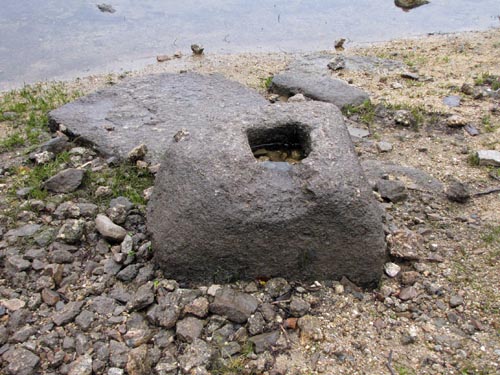
Purpose: Socket
stone for a wayside cross.
Size: The socket stone measures 29 inches (0.74 metres) wide, 16 inches
(0.41 metres) high and with its depth tapering from 27 inches (0.69
metres) down to 15 inches (0.38 metres). The size of the socket,
that would have held the base of the cross, is 8 inches (0.20 metres)
square by 6 inches (0.15 metres) deep.
Information: It
is thought that this socket stone was once used to support the Lowery
Cross on the other side of the reservoir, at Grid Reference: SX/555/692.
Although the cross has now disappeared, the socket stone was probably
brought across to Longstone Manor for safekeeping.
 It
seems as though the site of Longstone Manor was owned from at least the
13th century by
Herbert de Cumba, Lord of the Manor of Sheepstor. By the 15th
century the
Scudamore family owned the lands at Longstone before they passed it on to the
Elfords, when John Alford married Johanna Scudmore. Much of the present
building was re-built for Walter and Barbara Elford in 1633, according
to a date stone removed from the ruins, possibly taking in elements
of the earlier house. A mid 18th century map shows the main house to the
north, and outbuildings and a walled garden to the south (this area is
now under the reservoir waterline). Longstone ceased to be a Manor House in 1748
and passed out of the Elford family. It is recorded as being in the
ownership of William Smith in 1750, by which time the property had been
downgraded to a farmhouse. The farm was then passed down through two
subsequent generations before it was sold to Sir Massey Lopes in 1811, who removed
the attached west wing and courtyard, blocked the windows and
replaced them with sashes. It was later tenanted until 1897, with the
last tenant being Mr George Creber. It
seems as though the site of Longstone Manor was owned from at least the
13th century by
Herbert de Cumba, Lord of the Manor of Sheepstor. By the 15th
century the
Scudamore family owned the lands at Longstone before they passed it on to the
Elfords, when John Alford married Johanna Scudmore. Much of the present
building was re-built for Walter and Barbara Elford in 1633, according
to a date stone removed from the ruins, possibly taking in elements
of the earlier house. A mid 18th century map shows the main house to the
north, and outbuildings and a walled garden to the south (this area is
now under the reservoir waterline). Longstone ceased to be a Manor House in 1748
and passed out of the Elford family. It is recorded as being in the
ownership of William Smith in 1750, by which time the property had been
downgraded to a farmhouse. The farm was then passed down through two
subsequent generations before it was sold to Sir Massey Lopes in 1811, who removed
the attached west wing and courtyard, blocked the windows and
replaced them with sashes. It was later tenanted until 1897, with the
last tenant being Mr George Creber.
As
a consequence of the construction of Burrator Reservoir, which had begun
in 1893, the farm was abandoned in 1898 when the
valley adjacent to the site was flooded to create the Burrator
Reservoir, during which part of the estate was also flooded and the main
house abandoned. The house was noted as being in good repair at this
time. However, after the site was abandoned the roof was removed.
The
reservoir was expanded between 1923 and 1928, at which time the remains
of the outbuildings to the south of the main house were submerged. In
the early 20th century several granite artefacts were recovered
from Longstone Manor for safekeeping. These include the date-stones
of the house (1633) and windstrew, some doorways and a stone lectern, all
of which were re-sited in Wembley Walk, situated near the Burrator
Discovery Centre on the other side of the reservoir. Other items that have been recorded at Longstone
Manor, but which have now disappeared, include two mould stones, a mortar
stone, a granite feeding chute and a holed gate hanger stone.
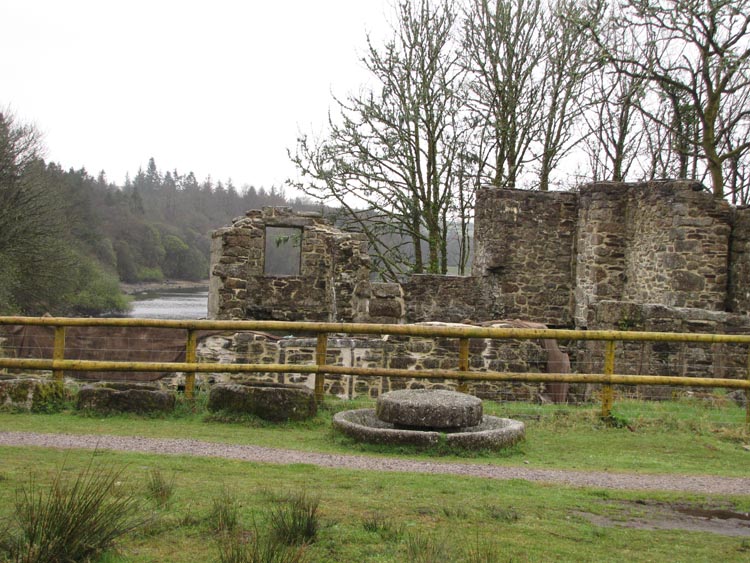
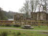
Since
the building was abandoned most of the east end stone walls were robbed
out and much of the ashlar facing was removed, with the exception of
that on the south elevation. In 1999 an archaeological recording survey
was carried out on both the remains of Longstone Manor house and the
associated structures below the waterline, at which point the water line
was low enough to survey and record the masonry walls. A midden to the
west of the house has produced tiles and post-medieval pottery sherds,
and the archaeological investigations of the submerged buildings have
uncovered medieval as well as post medieval pottery. These finds, in
conjunction with earlier reused masonry in the house and a fragment of
medieval arch identified within the wall of the sunken pathway, support
the likelihood that there has been an earlier occupation of this site.
Work to consolidate the masonry remains of the main house were carried
out in the late 20th century, including supporting the window openings, gateway
and the chimneypiece in the west wall.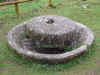
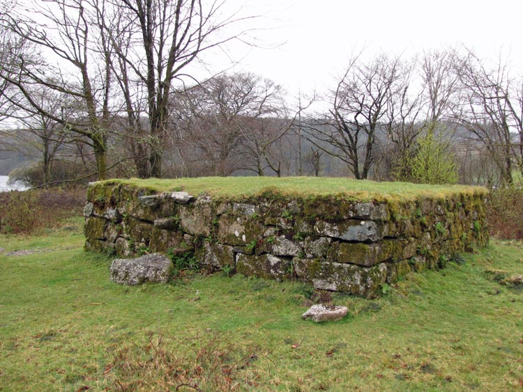
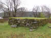 John
Elford, is understood to have
built the Windstrew (threshing platform), to the north-west of the
family farm, around 1640 and one of the granite steps up to the Windstrew bears the
inscription 'J. E. 1640'. The Windstrew must have suffered from dilapidation
over the years as it was partially rebuilt in 1800. At harvest time,
the sheaves of
corn were threshed by hand on the Windstrew and the breeze flowing over
the raised platform would blow
away the chaff leaving the grain to be scooped up and stored for future
use.
John
Elford, is understood to have
built the Windstrew (threshing platform), to the north-west of the
family farm, around 1640 and one of the granite steps up to the Windstrew bears the
inscription 'J. E. 1640'. The Windstrew must have suffered from dilapidation
over the years as it was partially rebuilt in 1800. At harvest time,
the sheaves of
corn were threshed by hand on the Windstrew and the breeze flowing over
the raised platform would blow
away the chaff leaving the grain to be scooped up and stored for future
use.
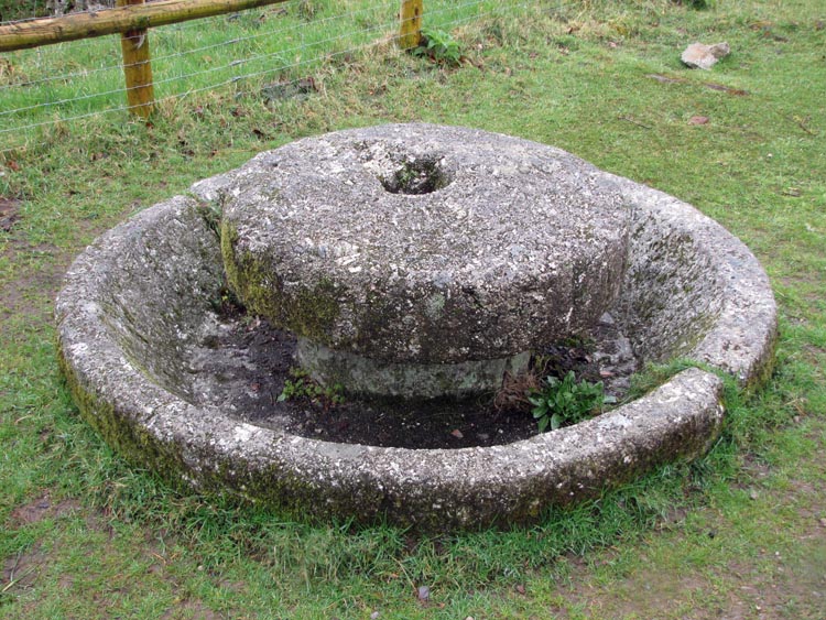
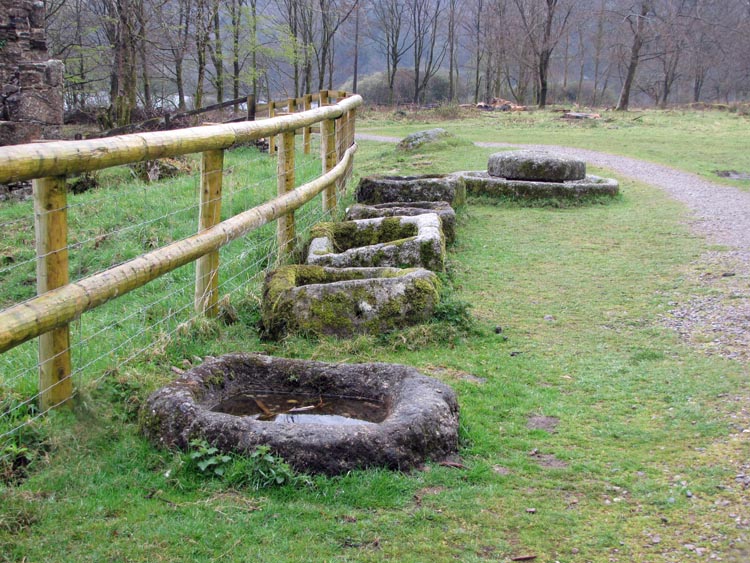
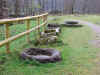 Evidence
of cider making at the manor is provided by the apple mill which sits
beside the fence around the manor buildings. This would have been used to
crush the apples into a pulp prior to them being put into the press to
have the juice extracted. The cider house was predominately made
from timber, as was the press, and both have now disappeared over the
years. There are also a number of granite troughs
scattered around the site, five of which are lined up alongside the fence
with the apple mill. Evidence
of cider making at the manor is provided by the apple mill which sits
beside the fence around the manor buildings. This would have been used to
crush the apples into a pulp prior to them being put into the press to
have the juice extracted. The cider house was predominately made
from timber, as was the press, and both have now disappeared over the
years. There are also a number of granite troughs
scattered around the site, five of which are lined up alongside the fence
with the apple mill.
Our thanks to Robert Noakes for bringing this
socket stone to our
attention.
|