|
Devon Marker Stones |

|
|||||||||||||||||||||
 |
 |
 |
 |
 |
 |
 |
 |
 |
 |
 |
 |
|
||||||||||||||||||||||||||||||||||||||||||
| District: | Teignbridge |
|
||||||||||||||||||||||||||||||||||||||||
| Parish: | Dunsford | |||||||||||||||||||||||||||||||||||||||||
|
|
|||||||||||||||||||||||||||||||||||||||||
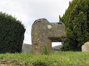
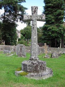
| Stone Type: | Churchyard Cross | |||||||||||||||||||||||||||||||||||||||||
| Grid Reference: | SX/8129/8919 | |||||||||||||||||||||||||||||||||||||||||
| Location: | To the left of the main path leading to the church. | |||||||||||||||||||||||||||||||||||||||||
| Notes: | Further details of the cross may be found at Dunsford Churchyard | |||||||||||||||||||||||||||||||||||||||||
|
||||||||||||||||||||||||||||||||||||||||||
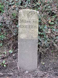
| Stone Type: | Milestone | |||||||||||||||||||||||||||||||||||||||||
| Grid Reference: | SX/8267/8936 | |||||||||||||||||||||||||||||||||||||||||
| Location: | On the south side of the B3212, tight against the bank and down the hill from the Two Crosses crossroads. | |||||||||||||||||||||||||||||||||||||||||
| Inscription: | 6 Miles To Exeter | |||||||||||||||||||||||||||||||||||||||||
| Notes: | The stone also has an Ordnance Survey Benchmark | |||||||||||||||||||||||||||||||||||||||||
|
||||||||||||||||||||||||||||||||||||||||||
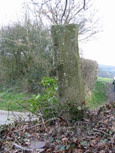
| Stone Type: | Wayside Cross | |||||||||||||||||||||||||||||||||||||||||
| Grid Reference: | SX/8281/8941 | |||||||||||||||||||||||||||||||||||||||||
| Location: | High on the bank in the south-west corner of the Two Crosses crossroads. | |||||||||||||||||||||||||||||||||||||||||
| Notes: | Further details of the cross may be found at Two Crosses Cross | |||||||||||||||||||||||||||||||||||||||||
|
||||||||||||||||||||||||||||||||||||||||||
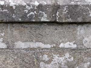
| Stone Type: | Boundary Stone | |||||||||||||||||||||||||||||||||||||||||
| Grid Reference: | SX/8049/8832 | |||||||||||||||||||||||||||||||||||||||||
| Location: | Built into the north west parapet of Steps Bridge, slightly to the north east of centre. | |||||||||||||||||||||||||||||||||||||||||
| Inscription: | DUNSFORD | |||||||||||||||||||||||||||||||||||||||||
|
||||||||||||||||||||||||||||||||||||||||||
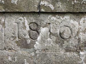
| Stone Type: | Steps Bridge Marker Stone | |||||||||||||||||||||||||||||||||||||||||
| Grid Reference: | SX/804/883 | |||||||||||||||||||||||||||||||||||||||||
| Location: | Built into the south-east parapet of Steps Bridge | |||||||||||||||||||||||||||||||||||||||||
| Inscription: | 1816 | |||||||||||||||||||||||||||||||||||||||||
|
||||||||||||||||||||||||||||||||||||||||||
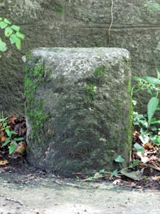
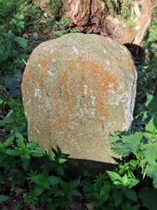
| Stone Type: | Marker Stone | |||||||||||||||||||||||||||||||||||||||||
| Grid Reference: | SX/8052/8831 | |||||||||||||||||||||||||||||||||||||||||
| Location: | Against the wall, opposite the entrance to Dunsford Woods | |||||||||||||||||||||||||||||||||||||||||
| Inscription: | There is no visible inscription. | |||||||||||||||||||||||||||||||||||||||||
| Notes: | The original purpose of this stone is not known. | |||||||||||||||||||||||||||||||||||||||||
|
||||||||||||||||||||||||||||||||||||||||||
| Stone Type: | Churchyard Cross | |||||||||||||||||||||||||||||||||||||||||
| Grid Reference: | SX/8130/8923 | |||||||||||||||||||||||||||||||||||||||||
| Location: | In a large burial plot at the rear of Dunsford Church. | |||||||||||||||||||||||||||||||||||||||||
| Inscription: | BEAR UP | |||||||||||||||||||||||||||||||||||||||||
| Notes: | Further details of the cross may be found at Fulford Cross | |||||||||||||||||||||||||||||||||||||||||
|
||||||||||||||||||||||||||||||||||||||||||
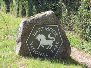
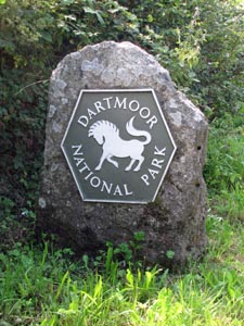
| Stone Type: | Boundary Stone | |||||||||||||||||||||||||||||||||||||||||
| Grid Reference: | SX/8176/8890 | |||||||||||||||||||||||||||||||||||||||||
| Location: | On the northern grass verge of the B3212 | |||||||||||||||||||||||||||||||||||||||||
| Inscription: | Dartmoor National Park | |||||||||||||||||||||||||||||||||||||||||
|
||||||||||||||||||||||||||||||||||||||||||
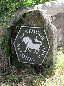
| Stone Type: | Boundary Stone | |||||||||||||||||||||||||||||||||||||||||
| Grid Reference: | SX/8176/8889 | |||||||||||||||||||||||||||||||||||||||||
| Location: | On the southern grass verge of the B3212 | |||||||||||||||||||||||||||||||||||||||||
| Inscription: | Dartmoor National Park | |||||||||||||||||||||||||||||||||||||||||
|
||||||||||||||||||||||||||||||||||||||||||
| Stone Type: | Boundary Stone | |||||||||||||||||||||||||||||||||||||||||
| Grid Reference: | SX/8235/8842 | |||||||||||||||||||||||||||||||||||||||||
| Location: | At the north eastern end of the parapet of Sowton Mill Bridge. | |||||||||||||||||||||||||||||||||||||||||
| Inscription: | Dartmoor National Park | |||||||||||||||||||||||||||||||||||||||||
|
||||||||||||||||||||||||||||||||||||||||||
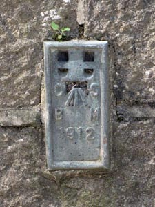
| Stone Type: | Marker Plate | |||||||||||||||||||||||||||||||||||||||||
| Grid Reference: | SX/8234/8842 | |||||||||||||||||||||||||||||||||||||||||
| Location: | Fixed to the north western parapet of Sowton Mill Bridge. | |||||||||||||||||||||||||||||||||||||||||
| Inscription: | O S / B M / 1912 | |||||||||||||||||||||||||||||||||||||||||
| Notes: | The inscription refers to: Ordnance Survey Bench Mark, with the serial number of the plate (1912). | |||||||||||||||||||||||||||||||||||||||||
|
||||||||||||||||||||||||||||||||||||||||||
| Stone Type: | Milestone | |||||||||||||||||||||||||||||||||||||||||
| Grid Reference: | SX/7959/8825 | |||||||||||||||||||||||||||||||||||||||||
| Location: | Under the road barrier, towards the top of the hill from Steps Bridge. | |||||||||||||||||||||||||||||||||||||||||
| Inscription: | IIII Miles (4 Miles) from Moreton | |||||||||||||||||||||||||||||||||||||||||
| Notes: | The inscription is now all but illegible. | |||||||||||||||||||||||||||||||||||||||||