| |
|
|
|
|
|
|
|
|
|
|
|
|
| |
|
|
|
|
|
|
|
|
|
|
|
|
|
|
|
|
|
|
|
|
District: |
West
Devon |
|
|
|
|
|
|
|
|
|
|
|
 |
|
| |
|
|
|
|
|
|
|
|
|
|
|
|
|
|
|
|
|
|
Parish: |
Lydford |
 |
 |
 |
|
|
|
|
| |
|
|
|
|
|
|
|
|
|
|
|
|
|
|
|
|
|
|
|
| |
|
|
|
|
|
|
|
|
|
|
|
|
|
|
|
|
|
|
|
| |
|
|
|
|
|
|
|
|
|
|
|
|
|
|
|
|
|
|
|
| Page
Contents: |
|
| |
9 Boundary Stones |
| |
1 Cross |
| |
3
Marker Stones |
| |
3
Milestones |
| |
|
| |
|
|
|
|
|
|
|
|
|
|
|
|
|
|
|
|
|
| |
|
|
|
|
|
|
|
|
|
|
|
|
| |
|
|
|
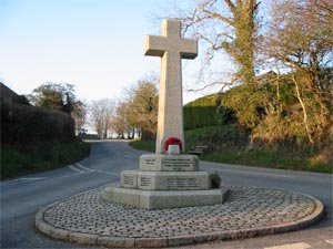
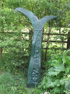
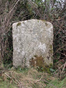
Stone Type: |
Village Cross |
| |
|
|
|
Grid Reference: |
SX/5130/8511 |
| |
|
|
|
Location: |
In the middle of the road junction in the centre of Lydford. |
| |
|
|
|
Inscription: |
To the Honoured Memory of those, from this Parish, who gave their Lives for
King, Country and Freedom. 1914–1918 |
| |
|
|
|
Notes: |
For
more information on this cross, see dartmoor-crosses.org.uk |
|
|
|
|
|
|
|
|
|
|
|
|
|
|
|
|
|
|
|
|
|
|
|
|
|
|
|
|
|
|
|
| |
|
|
|
|
|
|
|
|
|
|
|
|
|
|
|
|
| |
|
|
|
|
|
|
|
|
|
|
|
|
|
|
|
|
|
Stone Type: |
Milestone |
|
|
|
|
|
|
|
|
|
Grid Reference: |
SX/5088/8467 |
|
|
|
|
|
|
|
|
|
Location: |
Set against the wall at the entrance to Lydford Castle |
|
|
|
|
|
|
|
|
|
Inscription: |
8 T / 9 O (8 Tavistock / 9 Okehampton) |
|
|
|
|
|
|
|
|
|
|
|
|
|
|
|
|
|
|
|
|
|
|
|
|
|
|
|
|
|
|
|
|
|
|
|
|
|
|
|
|
|
|
|
|
|
|
|
|
|
|
|
|
|
|
|
|
|
|
|
|
|
|
|
|
|
|
|
|
|
|
|
|
|
|
|
|
|
|
|
|
|
|
|
|
|
|
|
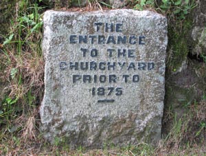
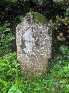
Stone Type: |
Churchyard Marker Stone |
|
|
|
|
|
|
|
|
Grid Reference: |
SX/5094/8475 |
|
|
|
|
|
|
|
|
Location: |
Built into the bank, just inside the main gate to the Churchyard and to the
right of the main path. |
|
|
|
|
|
|
|
|
Inscription: |
The Entrance to the Churchyard Prior to 1875 |
|
|
|
|
|
|
|
|
|
|
|
|
|
|
|
|
|
|
|
|
|
|
|
|
|
|
|
|
|
|
|
|
|
|
|
|
|
|
|
|
|
|
|
|
|
|
|
|
|
|
|
|
|
|
|
|
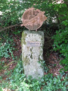
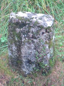
Stone Type: |
Saxon
Marker
Stone |
|
|
|
|
|
|
|
|
|
Grid Reference: |
SX/5094/8473 |
|
|
|
|
|
|
|
|
|
Location: |
On
the footpath, opposite the churchyard wall. |
|
|
|
|
|
|
|
|
|
Inscription: |
Llydanforde
- Site of Danish Saxon Conflict 997 AD |
|
|
|
|
|
|
|
|
| Notes |
In
commemoration of 70th anniversary of Lydford W.I. 1990 |
|
|
|
|
|
|
|
|
|
|
|
|
|
|
|
|
|
|
|
|
|
|
|
|
|
|
|
|
|
|
|
|
|
|
|
|
|
|
|
|
|
|
|
|
|
|
|
|
|
|
|
|
|
|
|
|
|
|
|
|
|
|
|
|
|
|
|
|
|
|
|
|
|
|
|
|
|
|
|
|
|
|
|
|
|
|
|
|
|
|
|
|
|
|
|
|
|
|
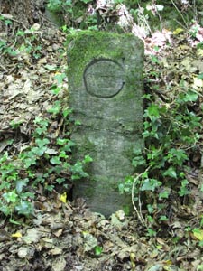
Stone Type: |
Boundary
Stone |
|
|
|
|
|
|
|
|
|
Grid Reference: |
SX/5094/8448 |
|
|
|
|
|
|
|
|
|
Location: |
30
metres south of the entrance to Lydford Gorge |
|
|
|
|
|
|
|
|
|
Inscription: |
C
- (County Bridge Stone - see note on Home Page) |
|
|
|
|
|
|
|
|
|
|
|
|
|
|
|
|
|
|
|
|
|
|
|
|
|
|
|
|
|
|
|
|
|
|
|
|
|
|
|
|
|
|
|
|
|
|
|
|
|
|
|
|
|
|
|
|
|
|
|
|
|
|
|
|
|
|
|
|
|
|
|
|
|
|
|
|
Stone Type: |
Boundary
Stone |
|
|
|
|
|
|
|
|
Grid Reference: |
SX/5026/8322 |
|
|
|
|
|
|
|
|
Location: |
On
the western verge of the road, under the trees. |
|
|
|
|
|
|
|
|
Inscription: |
Dartmoor
National Park |
|
|
|
|
|
|
|
| Notes: |
Marks
the boundary of the National Park. |
|
|
|
|
|
|
|
|
|
|
|
|
|
|
|
|
|
|
|
|
|
|
|
|
|
|
|
|
|
|
|
|
|
|
|
|
|
|
|
|
|
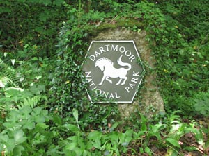
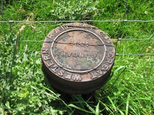
Stone Type: |
Boundary
Marker |
|
|
|
|
|
|
|
|
|
Grid Reference: |
SX/5016/8314 |
|
|
|
|
|
|
|
|
|
Location: |
On
the opposite side of the road to the southern entrance to Lydford Gorge. |
|
|
|
|
|
|
|
|
|
Inscription: |
Great
Western Railway Cos. Boundary 1895 |
|
|
|
|
|
|
|
|
|
|
|
|
|
|
|
|
|
|
|
|
|
|
|
|
|
|
|
|
|
|
|
|
|
|
|
|
|
|
|
|
|
|
|
|
|
|
|
|
|
|
|
|
|
|
|
|
|
Stone Type: |
Milestone |
|
|
|
|
|
|
|
|
|
Grid Reference: |
SX/5199/8616 |
|
|
|
|
|
|
|
|
|
Location: |
On
the Granite Way between Okehampton and Lydford. |
|
|
|
|
|
|
|
|
|
Inscription: |
3M
Sourton / 7½M Okehampton / Lydford ¾M / Tavistock |
|
|
|
|
|
|
|
|
| Notes: |
The
milestone was sponsored by the Royal Bank of Scotland. |
|
|
|
|
|
|
|
|
|
|
|
|
|
|
|
|
|
|
|
|
|
|
|
|
|
|
|
|
|
|
|
|
|
|
|
|
|
|
|
|
|
|
|
|
|
|
|
|
|
|
|
|
|
|
|
|
|
|
|
|
|
|
|
|
|
|
|
|
|
|
|
|
|
|
|
|
|
|
|
|
|
|
|
|
|
|
|
|
|
|
|
|
|
|
|
|
|
|
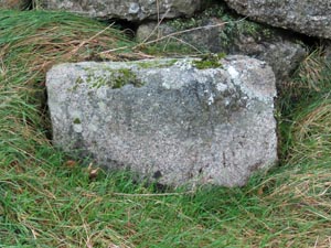
Stone Type: |
Boundary
Stone |
|
|
|
|
|
|
|
|
|
Grid Reference: |
SX/5285/8803 |
|
|
|
|
|
|
|
|
|
Location: |
At
the side of the Granite Way Foot/Cyclepath |
|
|
|
|
|
|
|
|
|
Inscription: |
L
(Lydford) |
|
|
|
|
|
|
|
|
|
|
|
|
|
|
|
|
|
|
|
|
|
|
|
|
|
|
|
|
|
|
|
|
|
|
|
|
|
|
|
|
|
|
|
|
|
|
|
|
|
|
|
|
|
|
|
|
|
|
|
|
|
|
|
|
|
|
|
|
|
|
|
|
|
|
|
|
|
|
|
|
|
|
|
|
|
|
|
|
|
|
|
|
|
|
|
Stone Type: |
Milestone |
|
|
|
|
|
|
|
|
|
Grid Reference: |
SX/5183/8434 |
|
|
|
|
|
|
|
|
|
Location: |
At
the entrance to the lane, just to the north of Higher Beardon and beside a
fingerpost. |
|
|
|
|
|
|
|
|
|
Inscription: |
Tavistock 7 Miles / Okehampton 8 / Truro 57. |
|
|
|
|
|
|
|
|
|
|
|
|
|
|
|
|
|
|
|
|
|
|
|
|
|
|
|
|
|
|
|
|
|
|
|
|
|
|
|
|
|
|
|
|
|
|
|
|
|
|
|
|
|
|
|
|
|
|
|
|
|
|
|
|
|
|
|
|
|
|
|
|
|
|
|
|
|
|
|
|
|
|
|
|
|
|
|
|
|
|
|
|
|
|
|
|
|
|
|
|
|
|
|
|
|
|
|
|
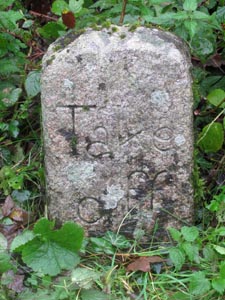
Stone Type: |
Boundary
Stone |
|
|
|
|
|
|
|
|
|
Grid Reference: |
SX/5183/8430 |
|
|
|
|
|
|
|
|
|
Location: |
In
the hedge, in the centre of the lay-by on the A386, just to the north of
Higher Beardon. |
|
|
|
|
|
|
|
|
|
Inscription: |
Take
Off |
|
|
|
|
|
|
|
|
|
Notes: |
This
stone marks the point where any additional horses would have to be
unhitched from their carriage, in the days of Turnpike Roads. |
|
|
|
|
|
|
|
|
|
|
|
|
|
|
|
|
|
|
|
|
|
|
|
|
|
|
|
|
|
|
|
|
|
|
|
|
|
|
|
|
|
|
|
|
|
|
|
|
|
|
|
|
|
|
|
|
|
|
|
|
|
|
|
Stone Type: |
Viking
Marker Stone |
|
|
|
|
|
|
|
|
|
Grid Reference: |
SX/509/847 |
|
|
|
|
|
|
|
|
|
Location: |
Just
inside the field between the Church and Castle. |
|
|
|
|
|
|
|
|
|
Notes: |
The
stone has been engraved with Viking Runic Symbols. |
|
|
|
|
|
|
|
|
|
|
|
|
|
|
|
|
|
|
|
|
|
|
|
|
|
|
|
|
|
|
|
|
|
|
|
|
|
|
|
|
|
|
|
|
|
|
|
|
|
|
|
|
|
|
|
|
|
|
|
|
|
|
|
|
|
|
|
|
|
|
|
|
|
|
|
|
|
|
|
|
|
|
|
|
|
|
|
|
|
|
|
|
|
|
|
|
|
|
|
|
|
|
|
|
|
|
|
|
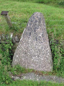
Stone Type: |
Boundary
Stone |
|
|
|
|
|
|
|
|
|
Grid Reference: |
SX/5177/8351 |
|
|
|
|
|
|
|
|
|
Location: |
Beside
the A386, on the opposite side of the road and to the north of the
Willsworthy Car Park. |
|
|
|
|
|
|
|
|
|
Notes: |
Although
the
inscription is no longer legible, it read 'Mary / Tavy' on the left-hand
side and 'Lamer / ton' on the right-hand side. |
|
|
|
|
|
|
|
|
|
|
|
|
|
|
|
|
|
|
|
|
|
|
|
|
|
|
|
|
|
|
|
|
|
|
|
|
|
|
|
|
|
|
|
|
|
|
|
|
|
|
|
|
|
|
|
|
|
|
|
|
|
|
|
|
|
|
|
|
|
|
|
|
|
|
|
|
|
|
|
|
|
|
|
|
|
|
|
|
|
|
|
|
|
|
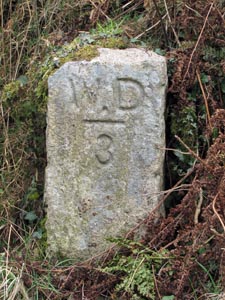
Stone Type: |
Boundary
Stone |
|
|
|
|
|
|
|
|
|
Grid Reference: |
SX/5178/8350 |
|
|
|
|
|
|
|
|
|
Location: |
Beside
the A386, on the same side of the road and to the north of the Willsworthy
Car Park. |
|
|
|
|
|
|
|
|
|
Inscription: |
W.
D. 3 (War Department No. 3) |
|
|
|
|
|
|
|
|
|
Notes: |
This
is one of a number of boundary stones used to mark the boundary of the
Willsworthy Firing Range. |
|
|
|
|
|
|
|
|
|
|
|
|
|
|
|
|
|
|
|
|
|
|
|
|
|
|
|
|
|
|
|
|
|
|
|
|
|
|
|
|
|
|
|
|
|
|
|
|
|
|
|
|
|
|
|
|
|
|
|
|
|
|
|
|
|
|
|
|
|
|
|
|
|
|
|
|
|
|
|
|
|
|
|
|
|
|
|
|
|
|
|
|
|
|
|
|
|
|
Stone Type: |
Boundary
Stone |
|
|
|
|
|
|
|
|
|
Grid Reference: |
SX/5237/8600 |
|
|
|
|
|
|
|
|
|
Location: |
On
the west side of the A386, beside the entrance to a property. |
|
|
|
|
|
|
|
|
|
Inscription: |
Dartmoor
National Park |
|
|
|
|
|
|
|
|
|
Notes: |
Marks
the boundary of the National Park. |
|
|
|
|
|
|
|
|
|
|
|
|
|
|
|
|
|
|
|
|
|
|
|
|
|
|
|
|
|
|
|
|
|
|
|
|
|
|
|
|
|
|
|
|
|
|
|
|
|
|
|
|
|
|
|
|
|
|
|
|
|
|
|
|
|
Stone Type: |
Boundary
Stone |
|
|
|
|
|
|
|
|
Grid Reference: |
SX/57556/74980 |
|
|
|
|
|
|
|
|
Location: |
On
the northern verge of the B3357 at Rundlestone |
|
|
|
|
|
|
|
|
Inscription: |
Walkhampton
/ Lydford |
|
|
|
|
|
|
|
|
|
|
|
|
|
|
|
|
|
|
|
|
|
|
|
|
|
|
|
|
|
|
|
|
|
|
|
|
|
|
|
|
|
|
|
|
|
|
|
|
|
|
|
|
|
|
|
|
|
|
|
|
|
|
|
|
|
|
|
|
|
| |
|
|
|
|
|
|
|
|
|
|
|
|
|
|
|
|
|
|
|
|
|
|
|
|
|
|
|
|
|
|
|
|
|
|
|
|
|
|
|