| |
|
|
|
|
|
|
|
|
|
|
|
|
| |
|
|
|
|
|
|
|
|
|
|
|
|
|
|
|
|
|
|
|
|
District: |
West Devon |
|
|
|
|
|
|
|
|
|
|
|
 |
|
| |
|
|
|
|
|
|
|
|
|
|
|
|
|
|
|
|
|
|
Parish: |
Mary Tavy |

|
 |

|
|
|
|
|
| |
|
|
|
|
|
|
|
|
|
|
|
|
|
|
|
|
|
|
|
| |
|
|
|
|
|
|
|
|
|
|
|
|
|
|
|
|
|
|
|
| |
|
|
|
|
|
|
|
|
|
|
|
|
|
|
|
|
|
|
|
| Page
Contents: |
|
| |
5 Boundary Stones |
| |
2
Crosses |
| |
1
Cross Base |
| |
1
Guide Stone |
| |
1
Marker Stone |
| |
5
Milestones |
|
|
|
|
|
|
|
|
|
|
|
|
|
|
|
|
|
| |
|
|
|
|
|
|
|
|
|
|
|
|
|
| |
|
|
|
|
|
|
|
|
|
|
|
|
|
| |
|
|
|
|
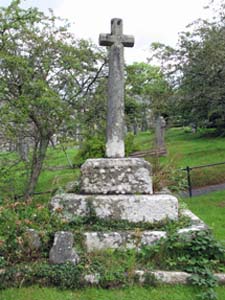
Stone Type: |
Mary Tavy Village Cross |
| |
|
|
|
|
Grid Reference: |
SX/5090/7873 |
| |
|
|
|
|
Location: |
Just inside the main gate to Mary Tavy churchyard. |
| |
|
|
|
|
Notes: |
For
more information on this cross, see dartmoor-crosses.org.uk |
| |
|
|
|
|
|
|
|
|
|
| |
|
|
|
|
|
|
|
|
|
|
|
|
|
|
|
|
| |
|
|
|
|
|
|
|
|
|
|
|
|
|
|
|
|
|
|
|
|
|
|
|
|
|
|
|
|
|
|
|
|
| |
|
|
|
|
|
|
|
|
|
|
|
|
|
|
|
|
|
|
|
|
|
|
|
|
|
|
|
|
|
|
|
Stone Type: |
Cross Head |
|
|
|
|
|
|
|
|
|
Grid Reference: |
SX/5090/7873 |
|
|
|
|
|
|
|
|
|
Location: |
Resting on the bottom pedestal of
the Mary Tavy Village Cross |
|
|
|
|
|
|
|
|
|
Notes: |
For
more information on this cross, see dartmoor-crosses.org.uk |
|
|
|
|
|
|
|
|
| |
|
|
|
|
|
|
|
|
|
|
|
|
|
|
|
|
|
|
|
|
|
|
|
|
|
|
|
|
|
|
|
|
|
|
|
|
|
|
|
|
|
|
|
|
|
|
|
|
|
|
|
|
|
|
|
|
|
|
|
|
|
|
|
|
|
|
|
|
|
|
|
|
|
|
|
|
|
|
|
|
|
|
|
|
|
|
|
|
|
|
|
|
|
|
|
|
|
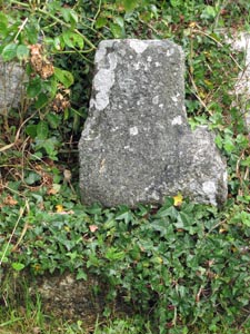
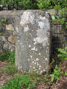
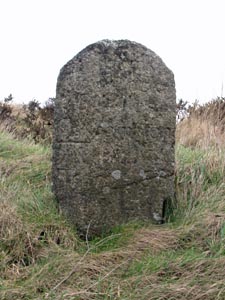
Stone Type: |
Boundary
Stone |
|
|
|
|
|
|
|
|
Grid Reference: |
SX/5177/8351 |
|
|
|
|
|
|
|
|
Location: |
On
the western verge of the A386, 50 metres north of the entrance to the
Willsworthy Firing Range. |
|
|
|
|
|
|
|
|
Notes: |
Although
the inscription is now undecipherable, the stone marks the boundary
between Mary Tavy and Lydford. |
|
|
|
|
|
|
|
|
|
|
|
|
|
|
|
|
|
|
|
|
|
|
|
|
|
|
|
| |
|
|
|
|
|
|
|
|
|
|
|
|
|
|
|
|
|
|
|
|
|
|
|
|
|
|
|
|
|
|
|
|
|
|
|
|
|
|
|
|
|
|
|
|
|
|
|
|
|
|
|
|
|
|
|
|
|
|
|
|
|
|
|
|
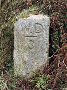
Stone Type: |
Boundary
Stone |
|
|
|
|
|
|
|
|
|
Grid Reference: |
SX/5178/8350 |
|
|
|
|
|
|
|
|
|
Location: |
On
the eastern verge of the A386, 50 metres north of the entrance to the
Willsworthy Firing Range. |
|
|
|
|
|
|
|
|
|
Inscription: |
W.
D. 3 (War Department No.3). |
|
|
|
|
|
|
|
|
|
Notes: |
This
is one of a number of stones that mark the boundary of the Willsworthy
Firing Range. |
|
|
|
|
|
|
|
|
|
|
|
|
|
|
|
|
|
|
|
|
|
|
|
|
|
|
|
|
|
|
|
|
|
|
|
|
|
|
|
|
|
|
|
|
|
|
|
|
|
|
|
|
|
|
|
|
|
|
|
|
|
|
|
|
|
|
|
|
|
|
|
|
|
|
|
|
|
|
|
|
|
|
|
|
|
|
|
|
|
|
|
|
|
|
|
|
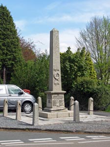
Stone Type: |
Village
Obelisk |
|
|
|
|
|
|
|
|
Grid Reference: |
SX/5025/7960 |
|
|
|
|
|
|
|
|
Location: |
At
the junction of the A386 with the minor road to Horndon. |
|
|
|
|
|
|
|
|
Inscription: |
1914
- Lest We Forget - 1918 |
|
|
|
|
|
|
|
|
Notes: |
The
obelisk serves as the village war memorial |
|
|
|
|
|
|
|
|
|
|
|
|
|
|
|
|
|
|
|
|
|
|
|
|
|
|
|
|
|
|
|
|
|
|
|
|
|
|
|
|
|
|
|
|
|
|
|
|
|
|
|
|
|
|
|
|
|
|
|
|
|
|
|
|
|
|
|
|
|
|
|
|
|
|
|
|
|
|
|
|
|
|
Stone Type: |
Guide
Stone |
|
|
|
|
|
|
|
|
|
Grid Reference: |
SX/5094/7878 |
|
|
|
|
|
|
|
|
|
Location: |
At
the north end of the Mary Tavy Churchyard. |
|
|
|
|
|
|
|
|
|
Inscription: |
Public
Footpath |
|
|
|
|
|
|
|
|
|
Notes: |
Stone
erected by the Dartmoor National Park Authority. |
|
|
|
|
|
|
|
|
|
|
|
|
|
|
|
|
|
|
|
|
|
|
|
|
|
|
|
|
|
|
|
|
|
|
|
|
|
|
|
|
|
|
|
|
|
|
|
|
|
|
|
|
|
|
|
|
|
|
|
|
|
|
|
|
|
|
|
|
|
|
|
|
|
|
|
|
|
|
|
|
|
|
|
|
|
|
|
|
|
|
|
|
|
|
|
|
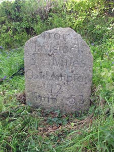
Stone Type: |
Milestone |
|
|
|
|
|
|
|
|
Grid Reference: |
SX/5046/7828 |
|
|
|
|
|
|
|
|
Location: |
On
the western verge of the A386. |
|
|
|
|
|
|
|
|
Inscription: |
From Tavistock 3 Miles / Oakhampton 12 / Truro 53 |
|
|
|
|
|
|
|
|
|
|
|
|
|
|
|
|
|
|
|
|
|
|
|
|
|
|
|
|
|
|
|
|
|
|
|
|
|
|
|
|
|
|
|
|
|
|
|
|
|
|
|
|
|
|
|
|
|
|
|
|
|
|
|
|
|
|
|
|
|
|
|
|
|
|
|
|
|
|
|
|
|
|
|
|
|
|
|
|
|
|
|
|
Stone Type: |
Milestone |
|
|
|
|
|
|
|
|
|
Grid Reference: |
SX/5025/7674 |
|
|
|
|
|
|
|
|
|
Location: |
Beside
the gate on the A386, opposite the Harford Bridge junction. |
|
|
|
|
|
|
|
|
|
Inscription: |
From Tavistock 2 Miles / Oakhampton 13 |
|
|
|
|
|
|
|
|
|
|
|
|
|
|
|
|
|
|
|
|
|
|
|
|
|
|
|
|
|
|
|
|
|
|
|
|
|
|
|
|
|
|
|
|
|
|
|
|
|
|
|
|
|
|
|
|
|
|
|
|
|
|
|
|
|
|
|
|
|
|
|
|
|
|
|
|
|
|
|
|
|
|
|
|
|
|
|
|
|
|
|
|
|
|
|
|
|
|
|
|
|
|
|
|
|
|
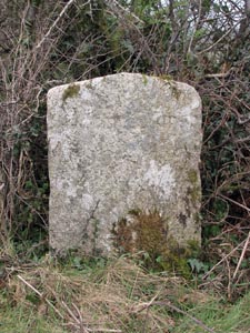
Stone Type: |
Boundary
Stone |
|
|
|
|
|
|
|
|
Grid Reference: |
SX/5022/7669 |
|
|
|
|
|
|
|
|
Location: |
Standing
against the north west parapet of Half Bridge. |
|
|
|
|
|
|
|
|
Inscription: |
Tavistock
/ Mary Tavy |
|
|
|
|
|
|
|
|
|
|
|
|
|
|
|
|
|
|
|
|
|
|
|
|
|
|
|
|
|
|
|
|
|
|
|
|
|
|
|
|
|
|
|
|
|
|
|
|
|
|
|
|
|
|
|
|
|
|
|
|
|
|
|
|
|
|
|
|
|
|
|
|
|
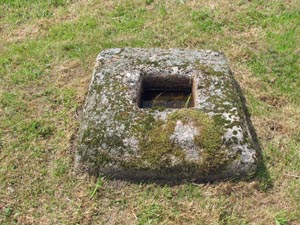
Stone Type: |
Cross
Base |
|
|
|
|
|
|
|
|
Grid Reference: |
SX/5204/8011 |
|
|
|
|
|
|
|
|
Location: |
On
the grass beside the signpost and opposite the postbox at Horndon |
|
|
|
|
|
|
|
|
Notes: |
For
more information on this cross, see dartmoor-crosses.org.uk |
|
|
|
|
|
|
|
|
|
|
|
|
|
|
|
|
|
|
|
|
|
|
|
|
|
|
|
|
|
|
|
|
|
|
|
|
|
|
|
|
|
|
|
|
|
|
|
|
|
|
|
|
|
|
|
|
|
|
|
|
|
|
|
|
|
|
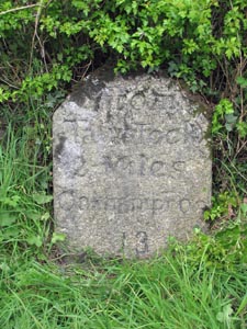
Stone Type: |
Milestone |
|
|
|
|
|
|
|
|
Grid Reference: |
SX/5046/8039 |
|
|
|
|
|
|
|
|
Location: |
At
the end of the roadside wall beside the Royal Standard Inn |
|
|
|
|
|
|
|
|
Inscription: |
Okehampton 11 Miles / Tavistock 4 Miles |
|
|
|
|
|
|
|
|
|
|
|
|
|
|
|
|
|
|
|
|
|
|
|
|
|
|
|
|
|
|
|
|
|
|
|
|
|
|
|
|
|
|
|
|
|
|
|
|
|
|
|
|
|
|
|
|
|
|
|
|
|
|
|
|
|
|
|
|
|
|
|
|
|
|
|
|
|
|
|
|
|
|
|
|
|
|
|
|
|
|
|
|
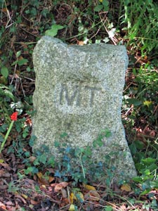
Stone Type: |
Boundary
Stone |
|
|
|
|
|
|
|
|
|
Grid Reference: |
SX/4869/8108 |
|
|
|
|
|
|
|
|
| Location: |
On
the grass verge to the east of Brentor Gate |
|
|
|
|
|
|
|
|
| Inscription: |
M
T (Mary Tavy) |
|
|
|
|
|
|
|
|
| Notes: |
Millennium
Boundary Stone marking parish boundary with Brentor. |
|
|
|
|
|
|
|
|
|
|
|
|
|
|
|
|
|
|
|
|
|
|
|
|
|
|
|
|
|
|
|
|
|
|
|
|
|
|
|
|
|
|
|
|
|
|
|
|
|
|
|
|
|
|
|
|
|
|
|
|
|
|
|
|
|
|
|
|
|
|
|
|
|
|
|
|
|
|
|
|
|
|
|
|
|
|
|
|
|
|
|
|
|
|
|
|
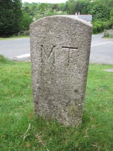
Stone Type: |
Millennium
Boundary Stone |
|
|
|
|
|
|
|
|
Grid Reference: |
SX/4905/7757 |
|
|
|
|
|
|
|
|
Location: |
On
the grass verge, just to the south of the farm entrance. |
|
|
|
|
|
|
|
|
Inscription: |
M
T (Mary Tavy) |
|
|
|
|
|
|
|
|
Notes: |
This
stone also marks the border of the Parishes of Tavistock and Lamerton. |
|
|
|
|
|
|
|
|
|
|
|
|
|
|
|
|
|
| |
|
|
|
|
|
|
|
|
|
|
|
|
|
|
|
|
|
|
|
|
|
|
|
|
|
|
|
|
|
|
|
|
|
|
|
|
|
|
|
|
|
|
|
|
|
|
|
|
|
|
|
|
|
|
|
|
|
|
|
|
|
|
|
|
Stone Type: |
Milestone |
|
|
|
|
|
|
|
|
|
Grid Reference: |
SX/5087/8133 |
|
|
|
|
|
|
|
|
|
Location: |
On
the western verge of the A386, 150 metres south of the gate to the Wheal
Betsy Engine House. |
|
|
|
|
|
|
|
|
|
Inscription: |
From Tavistock 5 Miles / Oakhampton 10 / Truro 55 |
|
|
|
|
|
|
|
|
|
|
|
|
|
|
|
|
|
|
|
|
|
|
|
|
|
|
|
|
|
|
|
|
|
|
|
|
|
|
|
|
|
|
|
|
|
|
|
|
|
|
|
|
|
|
|
|
|
|
|
|
|
|
|
|
|
|
|
|
|
|
|
|
|
|
|
|
|
|
|
|
|
|
|
|
|
|
|
|
|
|
|
|
|
|
|
|
|
|
|
|
|
|
|
|
|
|
Stone Type: |
Milestone |
|
|
|
|
|
|
|
|
Grid Reference: |
SX/5162/8278 |
|
|
|
|
|
|
|
|
Location: |
On
the eastern verge of A386, hidden amongst the grass. |
|
|
|
|
|
|
|
|
Inscription: |
From Tavistock 6 Miles / Oakhampton 9 / Truro 56. |
|
|
|
|
|
|
|
|
Notes: |
The
inscription has now become almost illegible. |
|
|
|
|
|
|
|
|
|
|
|
|
|
|
|
|
|
|
|
|
|
|
|
|
|
|
|
|
|
|
|
|
|
|
|
|
|
|
|
|
|
|
|
|
|
|
|
|
|
|
|
|
|
|
|
|
|
|
|
|
|
|
|
|
|
|
|
|
|
|
|
|
|
|
|
|
|
|
|
|
|
|
|
|
|
|
|
|
| |
|
|
|
|
|
|
|
|
|
|
|
|
|
|
|
|
|
|
|
|
|
|
|
|
|
|
|
|
|
|
|
|
|
|
|
|
|
|
|