Browse crosses
![]()
![]()
![]()

|
Browse crosses |
|
|
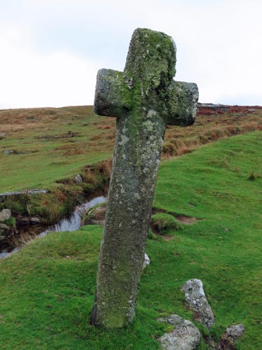
O/S Grid Ref: SX/53443/74297 Longitude/Latitude (Degrees+/-): -4.07005/50.55001 Map location: Click here to view map. Purpose: To mark the route of the Abbots’ Way across Whitchurch Common, from Merrivale Bridge to Moortown. Size: 6 feet 8 inches (2.03 metres) tall; 2 feet 3 inches (0.69 metres) across the arms. The shaft is 11½ inches (0.29 metres) wide by 11 inches (0.28 metres) deep. Information: This well-shaped cross, which is chamfered all round, is of a later period than most on the moor. William Crossing puts its age down to the 16th Century and suggests that it may be a replacement for a much older cross that once stood on this site. It is in good condition and, unlike most crosses on the open moor, doesn’t appear to have needed repair. The cross is set into a large socket stone which is largely in the ground, but does just show above ground to the west. The cross is currently tilted over at quite an angle to the west. This has probably more to do with livestock using it as a rubbing post than the open position, used in its alternative name of ‘Windy Post’, would suggest. Low down on the shaft, an Ordnance Survey benchmark has been incised on the southern face. The top of the benchmark is 18 inches up from the base of the shaft and it measures 6½ inches high by 5 inches wide.
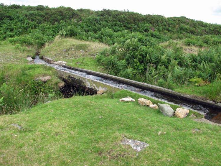
The Grimstone and Sortridge Leat, which is taken off the River Walkham about 4 kilometres to the north east, runs right past this cross. The leat then continues on its south westerly course to the 16th century manors of Grimstone and Sortridge, in the parish of Horrabridge. About 2/3 kilometre to the north east of the cross, the leat crosses over the Beckamoor Brook by way of a wooden launder. The launder has the name: ‘JOHN WILLS 1953 – 1987’ engraved into its top edge who, I assume, was the craftsman who built and fixed it into position.
The banks of the leat approaching the cross have been reinforced by some large granite boulders, in order to combat erosion caused by both humans and moorland animals at this popular and well-visited spot. At the cross the leat splits into two, in order that a branch can be used to supply water to some of the farms to the south, in the parish of Sampford Spiney. The main part of the leat passes over a small waterfall to the left but, as can be seen in the photo opposite, a measured amount of water is allowed to pass through the ‘bull’s-eye’ in the stone in the centre of the photo. The ‘bull’s-eye’ or ‘inch-hole’ is a common feature on Dartmoor for supplying a fixed amount of water to farms and private dwellings. There is another Ordnance Survey benchmark in top edge of this stone, with brass pin set into the stone at the head of the benchmark. |
|
|
 Location:
North
West of Feather Tor, beside the Grimstone and Sortridge Leat.
Location:
North
West of Feather Tor, beside the Grimstone and Sortridge Leat.