Browse crosses
![]()
![]()
![]()

|
Browse crosses |
|
 Location:
On Wigford Down, about 200 metres to the North West of Cadover Bridge and
close to the wall.
Location:
On Wigford Down, about 200 metres to the North West of Cadover Bridge and
close to the wall.
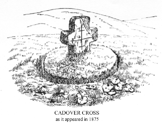
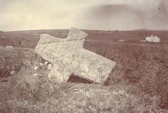
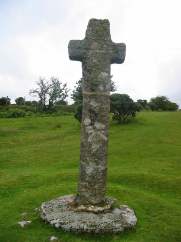
O/S Grid Ref: SX/55328/64716 Longitude/Latitude (Degrees+/-): -4.03975/50.46437 Map location: Click here to view map. Purpose: Waymarker on the Plympton Priory to Tavistock Abbey track. Size: 7 feet 9 inches (2.36 metres) tall. 2 feet 6 inches (0.76 metres) across the arms. Information: This cross is also sometimes referred to as the Cross on Wigford Down. In 1873, the original section of the cross was found lying flat on the ground by a group of soldiers who were on an exercise from their camp on Ringmoor Down.
In 1915, the Rev. Breton arranged for a new shaft to be made and fitted to the cross. In seeking a more secure site in which to erect the cross, he came across a green sward in the heather which he thought would make an ideal spot. Whilst digging a hole in the ground for the cross, he came across a large granite boulder which turned out to be the original socket stone for the cross, still in situ. This circular stone is unusual in that the socket goes right the way through it, a depth of 13 inches (0.33 metres). The stone was raised to ground level and the cross was once again set into it, as we still see it today. This is a well-shaped and solid cross, with the new section of shaft being fully 12 inches (0.30 metres) square. The height of the original cross, above the join, measures exactly 3 feet (0.92 metres). Although generally in fairly good condition, a fracture in the stone has meant that a piece has split away from one face of the cross. I should also add that great care was taken when selecting and shaping the new length of shaft, in order to ensure that it was a perfect match for the original cross. The Rev. Breton recorded the presence of three inscribed crosses on one face; one in the centre of each arm and the third in the middle of the head and centred on the arms. These would appear to be on the eastern face of the cross, but are now difficult to trace due to the weathering that has taken place over the years. William Crossing also suggests that the western face was similarly inscribed, but these are now so faint that they have all but disappeared. The Cadover Cross is one of a number erected to mark the route of the track that the monks of the Priory at Plympton would have used to visit their outlying parishes of Meavy and Sampford Spiney, on their way to Tavistock Abbey. At this time the monks would have crossed the River Plym by way of the ford, which can still be seen next to Cadover Bridge. Later a clam, or clapper bridge, was erected as a forerunner to the current road bridge. The name of ‘Cadover’ is thought to have derived from ‘Caed-a-ford’, which later evolved into ‘Cad-a-ford’ and ‘Cad-e-ver’. The word ‘Caed’ is old English for ‘place of battle’. It is interesting to speculate on the skirmishes that might have taken place between rival factions for supremacy, at this vital crossing place on the River Plym. |