 Location:
In
the back garden of Canonteign Manor House. Location:
In
the back garden of Canonteign Manor House.
O/S Grid Ref:
SX/8382/8312
Longitude/Latitude (Degrees+/-): -3.64413/50.63621
Map location:
Click here
to view map.
Purpose: Not
known.
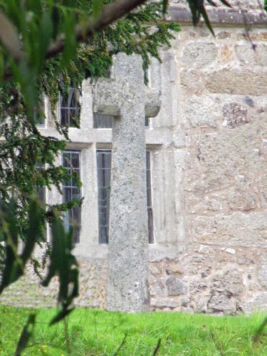
Size:
The cross is 8 feet 2 inches (2.49 metres) high and the shaft is 25 inches
(0.64 metres) wide by 13 inches (0.33 metres) in depth.
Information:
This cross stands in the back garden of Canonteign Manor on a raised tier
of lawn and quite close to the house. The tapering shaft is
chamfered on all four corners, from just above the base to the top of the
cross. The arms have also been chamfered in a similar fashion,
although the southern arm has suffered from damage at some point in the
past. The rectangular base of the shaft sits in a substantial socket
stone, which is 3 feet 3 inches (1.00 metres) square and rises to approximately 10 inches (0.25 metres) above the
ground. The socket has been chamfered down through all four corners, to match
the cross, and the top edge has been lightly chamfered all the way around. The
Canonteign Estate dates back to the Domesday Book of 1086, when it was
listed as "Teigne" - the 97th (out of 99) holding of Geoffrey de
Montebray, Bishop of Coutances, France. At the time it was occupied
by his tenant, Geoffrey de Trelly of Normandy. In about 1125, the
manor was passed to the Canons of the
Augustinian Abbey of St Mary du Val, Bayeux, Normandy by Jocelyn de la
Pomeray. It was at this time that the manor of "Teigne"
acquired its prefix to become "Canonteign". The Manor House is a Grade I listed 16th Century
building and has been lived in by various Lords of the Manor down through
the centuries. Canonteign Barton, which is situated on the opposite
side of the road, would have been the 'Home Farm' of the estate. Over
the years, the estate has passed through many families and, in 1812, it
was bought by Edward Pellew, 1st Viscount Exmouth (1757-1833). In
1928 it was his son, Pownoll Bastard Pellew, 2nd Viscount Exmouth who
had the
new Canonteign House built in the grounds of the Country Park, about 0.4 miles to the south of the Barton and
Manor houses. The family moved to this new house and Canonteign Manor
suffered a gradual decline thereafter. Fortunately, the house has
now been modernised in the 20th Century and in 2015 the house, together
with its 10 acres of garden and parkland, was sold on the
market for £2 million to a Chinese investor.  The
site of Wheal Exmouth Mine falls within the grounds of the Canonteign
Estate and abuts the southern border of the Manor house and gardens. A
public footpath currently runs through the site of the old mine, down to
the B3193 Teign Valley road. Mining on the site commenced in the 1820s and
it was found to be rich in Lead and Silver, as well as smaller amounts of
Zinc and Copper. A total of seven shafts were sunk at the site, with the
main shaft being excavated to a depth of 80 fathoms (480 feet). That
this was a profitable mine is confirmed by the fact that it had the best
machinery and plant in the West of England. In addition, the
buildings, rather than being plain and functional, are all of an
ornamental and fine appearance. In 1853, the mine merged with Wheal
Adams, which was a similar type of mine about ½ mile to the north (Grid
Ref: SX835/837)
of Wheal Exmouth. By the 1870's production at the mine was greatly
reduced and it was finally closed down in 1875. The main buildings
at the mine have now been converted to residential accomodation. The
site of Wheal Exmouth Mine falls within the grounds of the Canonteign
Estate and abuts the southern border of the Manor house and gardens. A
public footpath currently runs through the site of the old mine, down to
the B3193 Teign Valley road. Mining on the site commenced in the 1820s and
it was found to be rich in Lead and Silver, as well as smaller amounts of
Zinc and Copper. A total of seven shafts were sunk at the site, with the
main shaft being excavated to a depth of 80 fathoms (480 feet). That
this was a profitable mine is confirmed by the fact that it had the best
machinery and plant in the West of England. In addition, the
buildings, rather than being plain and functional, are all of an
ornamental and fine appearance. In 1853, the mine merged with Wheal
Adams, which was a similar type of mine about ½ mile to the north (Grid
Ref: SX835/837)
of Wheal Exmouth. By the 1870's production at the mine was greatly
reduced and it was finally closed down in 1875. The main buildings
at the mine have now been converted to residential accomodation.
|

