Browse crosses
![]()
![]()
![]()

|
Browse crosses |
|
 Location:
At the side of the road,
opposite the lane leading down to Lower Elsford Farm. Location:
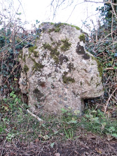
At the side of the road,
opposite the lane leading down to Lower Elsford Farm.O/S Grid Ref: SX/79231/82922 Longitude/Latitude (Degrees+/-): -3.70904/50.63344 Map location: Click here to view map. Purpose: Probable waymarker to the church at Moretonhampstead or Hennock. Size: 3 feet 7 inches (1.10 metres) high. 2 feet 7 inches (0.79 metres) across the arms. The shaft is 18 inches (0.46 metres) wide and 8 inches (0.20 metres) deep. Information: This thick set cross is roughly hewn and square in section. No part of it is tapered or has been chamfered. The arms are quite badly damaged and the left hand arm, looking from the road, has quite a large piece missing. There is no visible socket stone and the shaft is set straight into the ground. Currently, the majority of the shaft is below ground level and the cross appears a lot shorter than it actually is. It is easy to visualise that, when initially erected, this would have been an imposing and very prominent waymarker. One that would have been very hard to miss on one’s route to the local church. The first mention of this cross was by William Crossing, who records that it was found, buried in the hedge, by Dr W.J. Stephens of Moretonhampstead. Dr Stephens arranged for the hedge to be trimmed back so that the cross could be revealed. However, it disappeared again over the years as Harry Starkey reported that he made several unsuccessful attempts to locate it, between the years of 1965 and 1982. It was Starkey’s friend, Ernest Ilieve, who lived nearby and who again discovered the cross buried beneath the roadside debris. Thankfully, it is now well looked after and can be easily seen at the side of the road, opposite the lane which runs down to the farm. In June 1999, this cross was retrieved from its position and taken to the Dartmoor National Park Authority pound, at Bovey Tracy, for repair. On removal, it was found that the shaft had broken into two main pieces and that a further small piece had also come adrift. The three pieces were bonded together and a metal spike inserted to reinforce the two main sections. The total height of the cross was measured at this time to be 7 feet 3 inches (2.21 metres), of which about half now lies beneath ground level. The cross was replaced at the same location and to the same depth as it was before, in July 1999, under the supervision of the National Park’s assistant archaeologist, Jane Marchand. About two miles to the south east of the cross is the site of the Great Rock Mine. This is one of a few, now extinct, iron oxide mines in the hills above the picturesque valley of the River Teign. Another well known mine in this group is the Kelly Mine, which is adjacent to the A382 Moretonhampstead to Bovey Tracey road, about ½ mile to the south of Lower Elsford Farm. The iron oxide extracted from these mines was of a very high quality and used in the manufacture of paint. Great Rock was the largest of these mines and during the boom years it had lucrative contracts to supply their product for the manufacture of the battleship grey paint used on the Royal Navy’s fleet. It was also commissioned for the distinctive green paint used by the Great Western Railway on their rolling stock and bridges, including the Brunel Bridge over the River Tamar, at Plymouth. Although the ore extracted from this area was of a high quality, it was rather expensive to mine. The paint made from the ore was duller than those from elsewhere, but it was very durable and did not crack easily. Any cracking of the paint would let in moisture, which would create flaking and rusting of the metal below. In later years, it was mixed with cheaper foreign imports, which would help to both keep the price down and improve the quality of the imports. The ore was extracted by hand from the underground seams, crushed to a grit, and washed in water to allow the iron oxide to settle out. The water was then drawn off to leave the resultant iron oxide to dry out into a powder form. Like all underground mining operations, the work was undertaken in dark, dank and very dirty conditions.
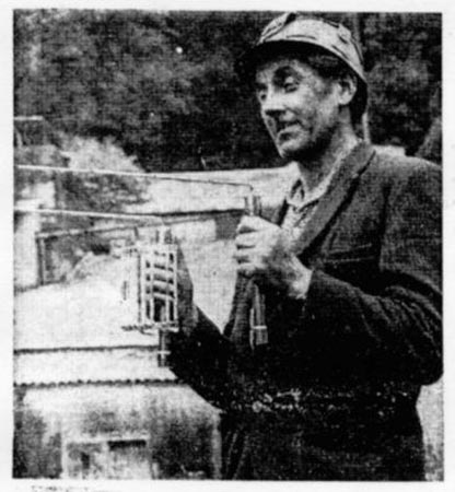
The photo opposite shows the mine manager, Bill Wills, demonstrating his divining device, used to locate the underground seams rich in iron oxide. I understand that there is a mining museum now being set up in the nearby buildings of the old Hawkmoor Hospital, on the outskirts of Bovey Tracey. |