Browse crosses
![]()
![]()
![]()

|
Browse crosses |
|
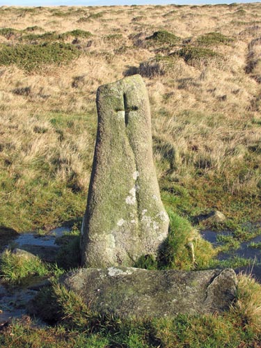 Location:
Set in a line of
North-South Boundary Stones running along the top of Piles Hill, about 250
yards South of the summit. Location:
Set in a line of
North-South Boundary Stones running along the top of Piles Hill, about 250
yards South of the summit.O/S Grid Ref: SX/65515/60477 Longitude/Latitude (Degrees+/-): -3.89478/50.42870 Map location: Click here to view map. Purpose: Boundary marker for the parishes of Harford and Ugborough. Size: 7 inches high, 5½ inches across the arms and incised onto a 4 foot (1.22 metres) high granite boulder, which is approx 1 foot (0.30 metres) wide at the top and 2 foot (0.61 metres) across the bottom. Information: The boulder now standing in this spot was never a cross in the accepted sense, but is a boundary stone with an incised cross on its western face. It stands in line with a number of other boundary stones which mark the boundary between the parishes of Ugborough and Harford. It is thought that the original Hobajohn's Cross stood in a line of boundary stones, marking the boundary of the parishes of Ugborough with South Brent, a short way to the north of Three Barrows. However, when Sir William Petre acquired the Manor of Brent he arranged for four crosses to be erected to mark the boundary of his recently acquired lands. It seems that Hobajohn's Cross was removed from its position in the line of boundary stones and set up on the centre cairn of Three Barrows as one of the four markers. The other three crosses were sited at Lower Huntingdon Corner, Western Whittaburrow and Buckland Ford, although the latter is now also missing. At some later time the cross was removed from its position on the central cairn and broken up. The head and one arm of this cross is now reported to be lying amongst the clitter around Three Barrows. There seems to be some confusion about the link between the current Hobajohn's Cross and the original one. However, it is clear that they are two separate crosses, with different stone being used for each one. It may be that people mistakenly thought that the modern cross is positioned in the same spot and is a replacement for the original but, nevertheless, I like the idea of this stone keeping the name of 'Hobajohn's Cross' in current use. |