Browse crosses
![]()
![]()
![]()

|
Browse crosses |
|
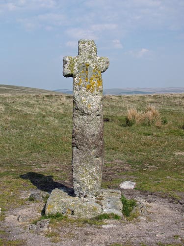 Location:
Holne
Moor, at the junction of the Monks’ Path and the track that runs
between South Brent and Hexworthy. Location:
Holne
Moor, at the junction of the Monks’ Path and the track that runs
between South Brent and Hexworthy.O/S Grid Ref: SX/66988/71042 Longitude/Latitude (Degrees+/-): -3.87781/50.52399 Map location: Click here to view map. Purpose: One of a number of crosses that marks the route of the Monks’ Path. This is the ancient name given to the track that links the Buckfast Abbey with those at Tavistock and Buckland. This path takes a more northerly route than the more commonly known Abbots’ Way. Size: 6 feet 2 inches (1.88 metres) high. 1 feet 10½ inches (0.57 metres) across the arms. The shaft is 15 inches (0.38 metres) wide and 14 inches (0.36 metres) deep. Information: The cross is erected at a place locally known as ‘Stacombe (or Stascombe) Telling-Place. This originated from a local farmer, by the name of Staddicombe, who used to pasture his sheep in the area. He used to round up his sheep at this place on a regular basis for the purpose of Counting or ‘Telling’ them. The cross itself is very old (circa 14th Century) and battered, with one arm badly mutilated. It is fairly certain that the shaft is not original, having been replaced at some time in the past. The head has been cemented onto the shaft and reinforced by the use of an iron clamp on both the front and back faces of the cross. The shaft is fixed into a large socket stone, which measures 2 feet 11 inches (0.89 metres), by 2 feet 9 inches (0.84 metres) and 9 inches (0.23 metres) high. |