Browse crosses
![]()
![]()
![]()

|
Browse crosses |
|
 Location:
At the South Eastern corner of Kennon
Hill, there are two large hollows set back into the hill. Just to the
South of these hollows there is a well-worn path which ascends the hill in
a North Westerly direction. Take this path and, after about 200 yards, the
boundary stone will appear directly in front of you. The following compass
bearings will also assist in locating the stone: Location:
At the South Eastern corner of Kennon
Hill, there are two large hollows set back into the hill. Just to the
South of these hollows there is a well-worn path which ascends the hill in
a North Westerly direction. Take this path and, after about 200 yards, the
boundary stone will appear directly in front of you. The following compass
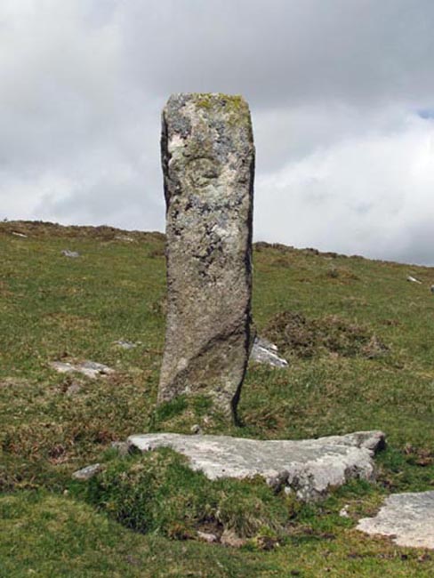
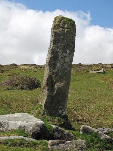
bearings will also assist in locating the stone:Kes Tor 149½ º. Top of Meldon Hill 124 º. Centre of largest clump of willow trees in marsh 050 º. Highest point of Buttern Tor 118 º. O/S Grid Ref: SX/64654/88936 Longitude/Latitude (Degrees+/-): -3.91725/50.68429 Map location: Click here to view map. Purpose: Boundary stone to mark the limit of both the Gidleigh and Throwleigh parishes. Size: The boundary stone is 6 feet 5 inches (1.95 metres) tall. 1 foot 2½ inches (0.37 metres) wide. 1 foot 4 inches (0.40 metres) deep. The incised cross measures 10 inches (0.25 metres) high by 6 inches (0.15 metres) across the arms. Information: The incised cross is on the North Eastern face of this boundary stone and there seems no obvious reason why it should have an engraved cross on it. However, it looks to me as though it was originally an engraved ‘T’ for ‘Throwleigh’, that has since been extended into a cross. Further evidence for this theory is provided by the fact that the engraving is on the side of the stone facing the parish of Throwleigh.
The Kennon Hill stone has obviously been shaped, as it is wider at the base than above. The surface of the base is a lot rougher and it almost gives the appearance that it is a socket stone, although closer examination will show that it is all one stone. The two tare and feather marks, near the top of its South Western face, provides further evidence of the stone being worked. Lying on the ground beside the boundary stone is another stone showing three tare and feather marks. The site of this boundary stone gives some fine views over the Eastern edge of the moor. In the foreground, across the marsh, is Buttern Hill, crowned by its scattered tor. To the right of this hill is the imposing Kes Tor Rock and further around again the trees of Fernworthy Forest can be seen clinging to the contours of the hills overlooking the North Teign River. Behind Buttern Hill the white painted houses of Chagford can be seen surrounding the church tower in the sheltered valley between Week Down and Meldon Hill. Further back Castle Drogo sits at the head of the valley, overlooking the tree-lined Fingle Glen. To the South West is the flat-topped rounded hump of Hameldown and the twin peaks of the Haytor Rocks. In good visibility the British Telecom mast at Waddlesdown, above Whitestone, can be seen in the far distance towards Exeter. A few minutes spent in admiring the views from here will be well rewarded. |