Browse crosses
![]()
![]()
![]()

|
Browse crosses |
|
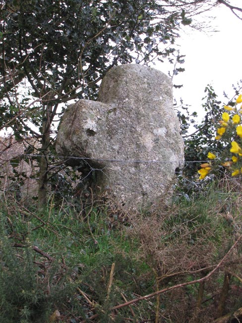
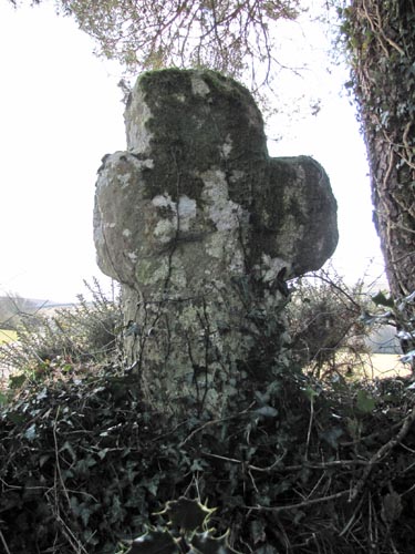 Location:
Just
off the Moretonhampstead to Postbridge road, on the track leading to
Moor Gate Farm. About 20 yards from the road, the cross is set on top of
the hedge beside the gate where the farm track passes through. Location:
Just
off the Moretonhampstead to Postbridge road, on the track leading to
Moor Gate Farm. About 20 yards from the road, the cross is set on top of
the hedge beside the gate where the farm track passes through.O/S Grid Ref: SX/70225/83322 Longitude/Latitude (Degrees+/-): -3.83646/50.63510 Map location: Click here to view map. Purpose: It is quite likely that this cross was originally erected near this spot to mark the junction of the ancient tracks between Exeter/Tavistock and Chagford/Bovey Tracey. Size: 3 feet 5 inches (1.04 metres) tall. 1 foot 11 inches (0.58 Metres) across the arms. The shaft is 15 inches (0.38 metres) wide by 13 inches (0.33 metres) deep. Information: This cross is obviously very old but is in quite good condition, apart from the northern arm having been broken off quite close to the shaft at some time. Had this still been in place, I calculate that its full width across the arms would be 2 feet 2 inches (0.66 metres). Although the shaft is now quite short it has been estimated, from its proportions, that the cross would originally have been over 6 feet tall.
In the early years of the 20th Century, the cross was found built into the garden wall at Moor Gate Farm. At the time, the farm was known as Leeper Farm, hence the name given to the cross. The cross was then moved to the Manor House at North Bovey, by the Lord of the Manor, Viscount Hambledon. It was returned to its current position when the manor changed hands in 1937. It is probable that sailors who, in medieval times, used to travel along the Mariner’s Way, between the ports on the north and south Devon coasts, also used the cross as a waymarker. The sailors would sign up to a ship and after their spell of duty would be dropped off at, say, one of the north Devon ports. If there was no immediate prospect of picking up another ship on the north Devon coast, they would walk across the county in the hope of finding a ship on the other coast. The same would, of course, apply in reverse. This section of the Mariner’s Way comes down from Jurston and Lettaford, in the north, passes through the gate beside the cross and continues on past the Moor Gate, West Combe and Lower Hookner Farms and beyond. One point of interest at West Combe Farm is that the track used to pass through the centre of an old stone barn. Although now quite ancient in itself, the barn must have been built on the pre-existing ‘right of way’, which was maintained by allowing passage to continue through the barn. More recently, the path has been redirected around the end of the barn. It is also thought that West Combe Farm was one of a number of rest houses along the route, where weary seamen could rest up for the night before continuing on their way the next morning. |