 Location:
High above the road, on the
left hand side and amongst the trees, on approaching Leigh Bridge from
Chagford. Location:
High above the road, on the
left hand side and amongst the trees, on approaching Leigh Bridge from
Chagford.O/S Grid Ref: SX/68352/87557
Longitude/Latitude (Degrees+/-): -3.86444/50.67274
Map location:
Click here
to view map.
Purpose: Probable
waymarker at nearby Teigncombe Farm, which is on the route of the ancient
Mariner’s Way.
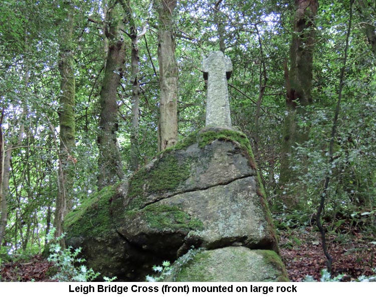
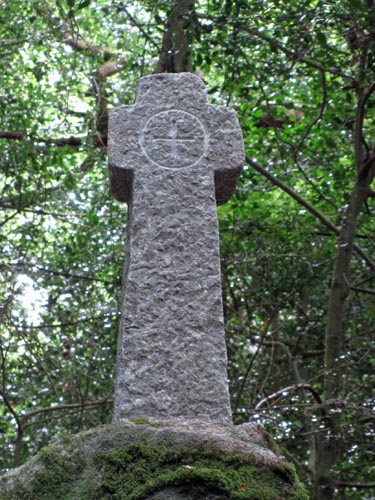
Size: The new
replacement cross measures 3 feet 6 inches (1.07 metres) high and 14
inches (0.36 metres) across the arms. The shaft, which tapers up
from the base, narrows from 11 inches (0.28 metres) to 8 inches (0.20
metres) wide and is 8½ inches (0.22 metres) deep. The incised cross
on the head measures 4½ inches (0.11 metres) by 4½ inches (0.11 metres),
within an incised circle which has a diameter of 7¼ inches (0.18
metres). The previous cross (see Information below) measured 4
feet (1.22 metres) high and 14 inches (0.36 metres) across the arms. The
incised cross was 5½ inches (0.14 metres) high and 4½ inches (0.11
metres) across the arms.
Information:
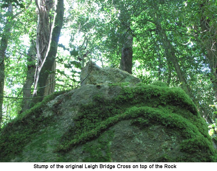
During
a previous visit to the area, in June 2015, the original cross was found to be missing.
On making enquiries, we were informed by 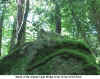 the Dartmoor National Park Authority that the granite
shaft had become weak over the years and that the cross had fallen over during the
winter of 2013/14. The
Park Authority rescued the cross and were holding it in storage until a decision
could be made on how best it might be repaired and restored to the site. The
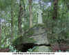
photo to the left shows the short length of shaft that remained
sticking out the top of the boulder where the break occurred. It now
seems as though the old cross was too weak to be repaired and put back out
on site. However, the National Park Authority commissioned a new
cross to be made as a replica of the original and this was placed out on
site during July 2019. the Dartmoor National Park Authority that the granite
shaft had become weak over the years and that the cross had fallen over during the
winter of 2013/14. The
Park Authority rescued the cross and were holding it in storage until a decision
could be made on how best it might be repaired and restored to the site. The
photo to the left shows the short length of shaft that remained
sticking out the top of the boulder where the break occurred. It now
seems as though the old cross was too weak to be repaired and put back out
on site. However, the National Park Authority commissioned a new
cross to be made as a replica of the original and this was placed out on
site during July 2019.
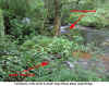
 The cross is set on top of
two large natural boulders, one on top of the other, and is half hidden by
the surrounding trees. The head and arms of the original cross were part of an ancient cross that
is thought to have once stood at Teigncombe Farm, about ¾ mile to the
south-west. A large circular socket stone, which is thought to have
originally supported this cross was, for many years, in use as a roadside
gatepost quite close to Teigncombe Farm.
However, on my visit to this site, in 2021, I found that the socket stone
had been replaced by a round wooden gatepost and the socket is now lying
on the ground, under the hedge, just inside the field. The rectangular
hole in the socket stone would appear to match the likely size of the
original shaft of the cross. As the Mariner’s Way, of which more detail
can be found on our page for Leeper Cross, passes
through Teigncombe Farm it is a likely place for an ancient cross to be
found. The cross is set on top of
two large natural boulders, one on top of the other, and is half hidden by
the surrounding trees. The head and arms of the original cross were part of an ancient cross that
is thought to have once stood at Teigncombe Farm, about ¾ mile to the
south-west. A large circular socket stone, which is thought to have
originally supported this cross was, for many years, in use as a roadside
gatepost quite close to Teigncombe Farm.
However, on my visit to this site, in 2021, I found that the socket stone
had been replaced by a round wooden gatepost and the socket is now lying
on the ground, under the hedge, just inside the field. The rectangular
hole in the socket stone would appear to match the likely size of the
original shaft of the cross. As the Mariner’s Way, of which more detail
can be found on our page for Leeper Cross, passes
through Teigncombe Farm it is a likely place for an ancient cross to be
found.
The original rugged cross was erected in position by a Mr Clampitt,
early in the 20th Century. The incised cross was on the roadside
face and the cemented joint, between the cross and the replacement shaft,
could clearly be seen. The new shaft, which was rectangular in section,
was
slightly tapered and was deliberately roughly hewn in an attempt to match
the cross. The width of the shaft reduced 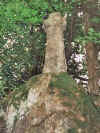 from 13 inches (0.33 metres) at
the base to 9 inches (0.23 metres) just below the arms and measured 7
inches (0.18 metres) in depth. The highest point of the boulders is 8 feet
9 inches (2.67 metres) above the bank immediately in front of them. from 13 inches (0.33 metres) at
the base to 9 inches (0.23 metres) just below the arms and measured 7
inches (0.18 metres) in depth. The highest point of the boulders is 8 feet
9 inches (2.67 metres) above the bank immediately in front of them.
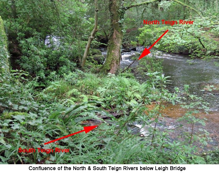
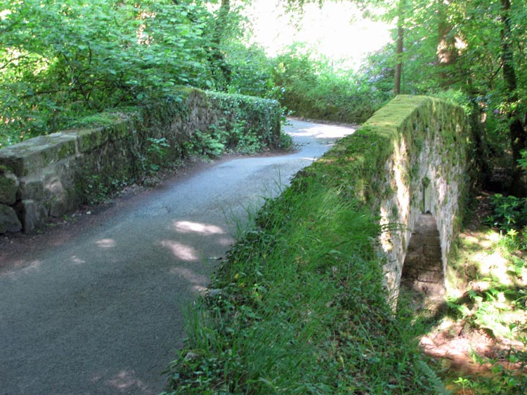
 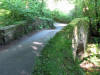 The picturesque
Leigh Bridge, which spans the South Teign River, stands just a few yards down the road from the cross,
immediately upstream of the confluence of the two Teign rivers. The North
Teign, flowing down through the woods below the Gidleigh Park Hotel,
meeting the South Teign, pouring down from the overflow of the Fernworthy
Reservoir. A little way downstream from the bridge, on the right hand bank
of the river and standing in private grounds is the Puggiestone. This
stone, which is set in a beautifully landscaped garden, is one of a number
of boundary stones around the parish of Chagford. The picturesque
Leigh Bridge, which spans the South Teign River, stands just a few yards down the road from the cross,
immediately upstream of the confluence of the two Teign rivers. The North
Teign, flowing down through the woods below the Gidleigh Park Hotel,
meeting the South Teign, pouring down from the overflow of the Fernworthy
Reservoir. A little way downstream from the bridge, on the right hand bank
of the river and standing in private grounds is the Puggiestone. This
stone, which is set in a beautifully landscaped garden, is one of a number
of boundary stones around the parish of Chagford.
|