Browse crosses
![]()
![]()
![]()

|
Browse crosses |
|
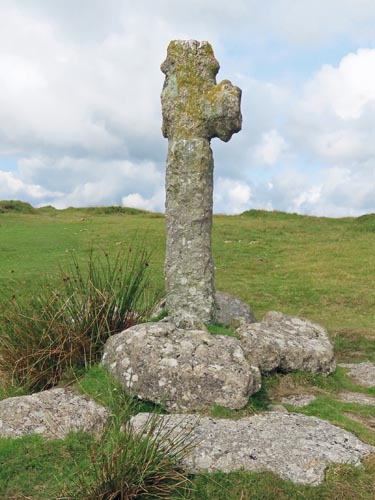 Location:
On Piles Hill, at the
junction of the tracks from the Owley moor gate to Harford and Wrangaton
to Erme Pound. Location:
On Piles Hill, at the
junction of the tracks from the Owley moor gate to Harford and Wrangaton
to Erme Pound.O/S Grid Ref: SX/65915/59976 Longitude/Latitude (Degrees+/-): -3.88897/50.42429 Map location: Click here to view map. Purpose: Waymarker for the above-mentioned tracks, of which the Owley Moor Gate to Harford track formed part of the Monks’ route from Buckfast Abbey to Plympton Priory. Size: 5 foot 6 inches (1.68 metres) tall. and 17 inches (0.43 metres) across the shaft and surviving arm. Information: This badly-mutilated cross was fashioned from a coarse-grained granite block, but is now minus its original shaft and one arm. The cross was restored to its current position by the Dartmoor Preservation Society in the 1930’s, at which time it was given a new shaft. 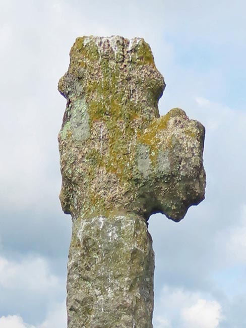 It
is unique amongst Dartmoor crosses in that the head and each of the arms
had 2 spurs projecting from them. These spurs measure about one and a half
inches long and two and a half inches wide. It must have made an
impressive sight to the wayfarer coming across it in the days when it was
in its prime. In order to get a better idea of how it would have looked
prior to the damage, our page on the Ermington
Church Porch Cross shows a very well preserved example. It
is unique amongst Dartmoor crosses in that the head and each of the arms
had 2 spurs projecting from them. These spurs measure about one and a half
inches long and two and a half inches wide. It must have made an
impressive sight to the wayfarer coming across it in the days when it was
in its prime. In order to get a better idea of how it would have looked
prior to the damage, our page on the Ermington
Church Porch Cross shows a very well preserved example.
|