Browse crosses
![]()
![]()
![]()

|
Browse crosses |
|
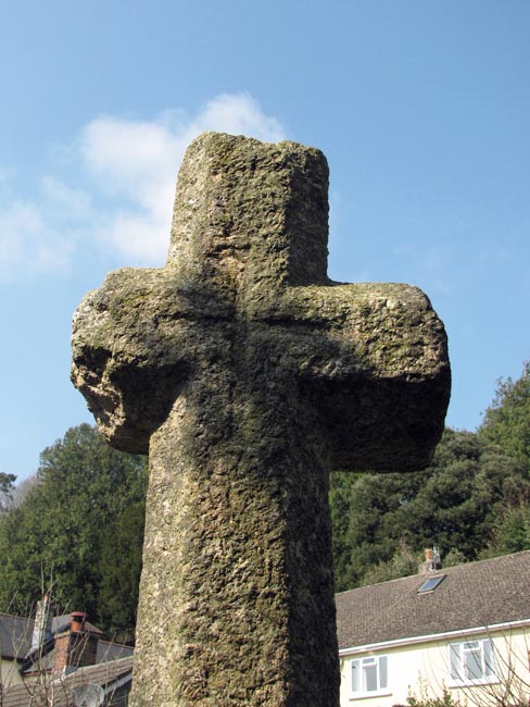
 Location:
Adjacent to St. Gudula’s
Well, on a green beside the Old Totnes Road, a turning off West Street. Location:
Adjacent to St. Gudula’s
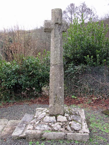
Well, on a green beside the Old Totnes Road, a turning off West Street.O/S Grid Ref: SX/75359/69364 Longitude/Latitude (Degrees+/-): -3.75922/50.51076 Map location: Click here to view map. Purpose: Village Cross. Size: 7 feet 2 inches (2.19 metres) tall. 1 foot 8 inches (0.51 metres) across the arms. The inscribed cross is 9 inches (0.23 metres) tall by 9 inches (0.23 metres) across the arms. Information: The shaft of this cross is made of two separate sections. The lower portion, which measures 3 feet 8 inches (1.12 metres), is from the original cross. The upper portion is modern and was put in place when the cross was restored to its current position, in 1933. The shaft is square for the bottom 8 inches (0.20 metres) and octagonal above, as are the head and arms. Prior to 1933, most of
the cross had been put to alternative use at the Gulwell Farm, about ¼
mile away. The lower portion of the cross was built into the ‘upping-stocks’
or ‘mounting block’, which was used as a platform from which to load
carts or to mount horses. The head and arms were found in the cider house
where they were being used to support one of the large cider vats.
Fortunately, these sections of the cross were able to be On the side facing the road there is a slot in the face of the cross, which measures 12 inches (0.30 metres) high by 3 inches (0.08 metres) wide. The purpose of this slot is not known but it is possible, as has been suggested for the Drywells Cross, that it served to hold a crucifix or other similar image. The incised cross is in the middle of the opposite face. On the same side as the slot and about 18 inches (0.46 metres) up from the base of the shaft there is, what appears to be, the remains of a gate hanger. William Crossing also recorded that the shaft had two holes drilled into it, to suggest that it has at some point in the past served duty as a gatepost.
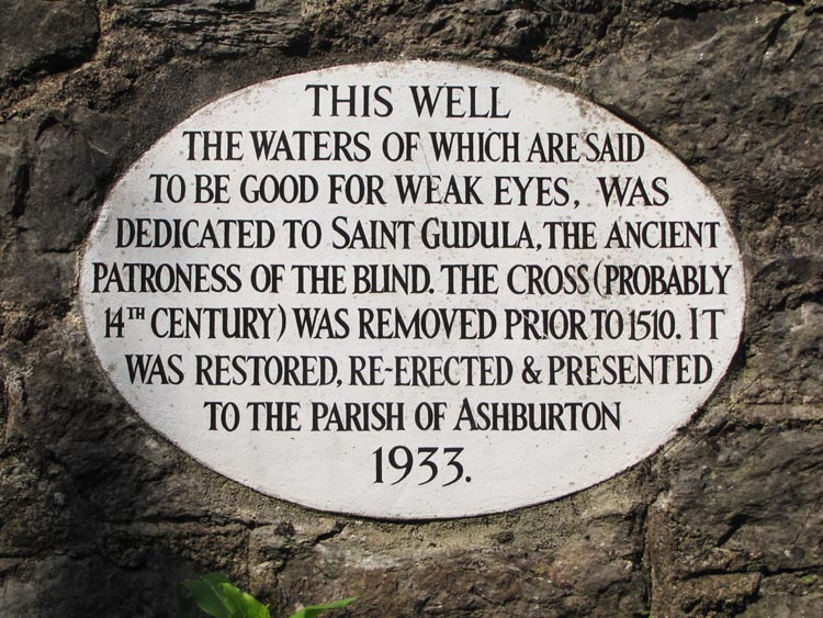
St Gudula, who was also known as Ergoule, was Flemish and died in 712 a.d. She is the patron saint of the weak-sighted and was the daughter of Count Witger and St Amalberga, who lived in the family castle of Morzelles. She was educated by St Gertrude of Nivelles and dedicated herself to God in 1664. Her feastday is celebrated on January 8th.
There is, however, a second school of thought that lays a claim to the cross and the well being of St Gulwall (or St Gulval), a Celtic Saint of the 6th century. He travelled this part of the country on many occasions and it was thought that he had blessed the well to give it its healing properties. The town of Ashburton is steeped in history and can lay claim to being one of the four Dartmoor Stannary Towns. The ingots of tin, that were mined and smelted on the moor, had to be taken to a Stannary Town where they were weighed, assayed, stamped, taxed and sold. At one stage, almost half of the tin mined on the moor was brought to Ashburton for processing. Records show the existence of Ashburton prior to the Norman Conquest, at which time it formed part of the vast estates of Bishop of Exeter. The records also show that it had a market in existence before 12th century. Previously there was a market cross, adjacent to market Hall, at junction of North Street with the East and West Streets. However, the hall was demolished in 1848 and probably the cross disappeared along with it. Ashburton was also a very important centre for the woollen trade, where the washing, carding, spinning and the weaving of the wool all took place within the town. |