| |
|
|
Location:
On the North side of the old A30,
about one mile to the West of Sticklepath, at the junction of the lane
that leads to Bude Farm.
O/S Grid Ref:
SX/63150/94773
Longitude/Latitude (Degrees+/-): -3.94069/50.73639
Map location: Click here
to view map.
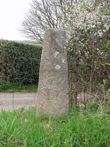
Purpose: Venville
Boundary Stone.
Size: The
stone is 4 feet 1 inch (1.25 metres) tall, 1 foot 4 inches (0.41 metres)
wide at the bottom, tapering to 10 inches (0.26 metres) at the top. 7½
inches (0.19 metres) in depth.
Information:
This stone is thought to have been a
boundary stone to mark the Venville Bounds of Belstone and Sampford
Courtenay in a similar manner to the
Sticklepath (Ladywell) Cross, situated about half a mile to the south
east of this stone. This stone appears to be undamaged except at the top, which is irregular
and shows signs of having been broken off relatively recently.
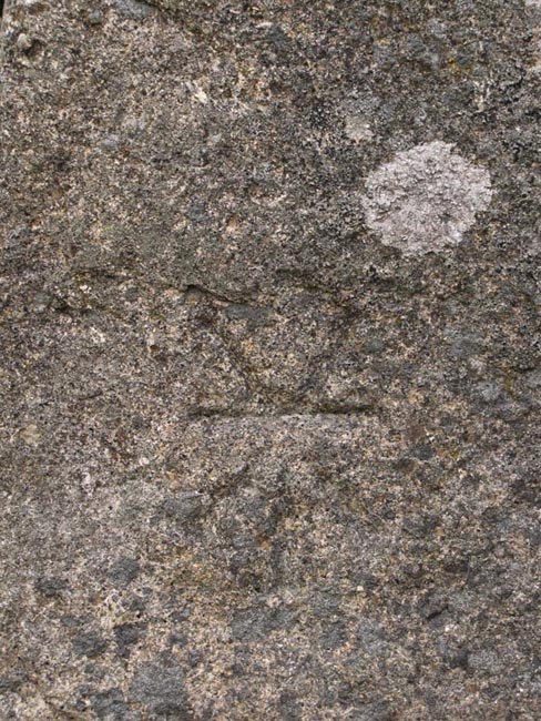
Although the markings on the stone are no longer very clear, they
originally included a St. Andrew's Cross. The stone is also of a
very similar style to that of the Sourton Green
Cross, on the village green  below
the Church. below
the Church.
Unfortunately, the
markings on this cross are not as clear as those on the Sourton Green
Cross. The only ones that are clearly visible are on the Southern,
roadside, face. Here, a seven pointed asterisk shape is incised about half
way down the stone. There is another line lower down on this face, but I
couldn’t, at first, determine its significance.
Research shows that,
originally, there were markings on three faces of this cross but, with the
exception of those set out above, they appear to have weathered or faded
away over the years. The original markings on each face were described as
follows:
|
 |
| Northern
Face: |
This face
originally contained the clearest engravings, which extended from
the top to the bottom of the stone. Starting from the top, there
was a circle 1½ inches in diameter, of which the upper arc was
missing due to a previous fracture of the top of the stone. This
was followed by another circle of the same size and a third
circle, this latter being rather larger at 11 inches in diameter.
At the bottom was a St. Andrew’s Cross, the arms of which used
the full width of the face and with the shaft reaching almost to
the base of the stone. |
| Eastern
Face: |
This showed a
number of lines with a faint resemblance to an imperfect human
figure, with a halo around its head. This consisted of a segment of
a circle, convex surface uppermost, towards the top of the stone
(halo). A few inches below this was a circle of 5 inches in diameter
(head), followed by an oval (body), 7 inches long and with the upper
portion obliterated. Two waved lines (legs) appeared from the bottom
of the oval, similar in shape but a mirror image of each other.
These both terminated at each edge of the stone, about 12 inches
above the ground. |
| Southern
Face: |
No markings were
recorded for the top half of the stone. The lower half had three
semicircles, with the curved sides adjacent to and equidistant from
each other; Two side by side and the third above. |
| Western
Face: |
No markings were
recorded for this face. It is not known if it has always been plain
or if there were some markings, which had already faded away before
the significance of this stone was realised. |
|
| Taking the above description into account
and the clarity of the incised asterisk, it is now obvious this must be a fairly
recent addition to the stone. However, the lower line that can be seen on the
same face may well be part of one of the semicircles described above. Mr Spence Bate recorded in 1874 that the stone was 4 feet 6 inches high and that it had been broken off at the top. My
measurement is now 4 feet 1 inch, some 5 inches shorter, and the top shows signs of a relatively recent fracture.
This would indicate that it has been further damaged within the last 125 years.
Ruth St. Leger-Gordon, in her book 'The Witchcraft and Folklore of
Dartmoor', refers to this stone as a menhir with the name of 'Honest
Man'. She goes on to two proffer two legends as to how the stone
might have acquired it's name. The first was that in the old
days a sailor was following the Mariner's Way in order that he might
find work on a ship in North Devon when he stopped for refreshment at
the Sticklepath inn. Setting off on his journey again, and
suffering somewhat from his drink, he became disorientated after
ascending the hill outside the village. Peering around in the
darkness, he saw what he thought was a figure ahead and ran up and
embraced it as his saviour, asking 'Be you an honest man?', and so the
stone was named.
The other legend relates how a traveller was set upon by highwaymen
at this spot and relieved of his purse. Fortunately for him, at
the very same moment a good Samaritan rode up on his horse, retrieved
his purse, saw off the thieves and rendered first aid to him.
The unknown good Samaritan then just rode off without revealing his
identity. The grateful traveller decided that he would erect
this stone on the spot in commemoration of 'so honest a man'.
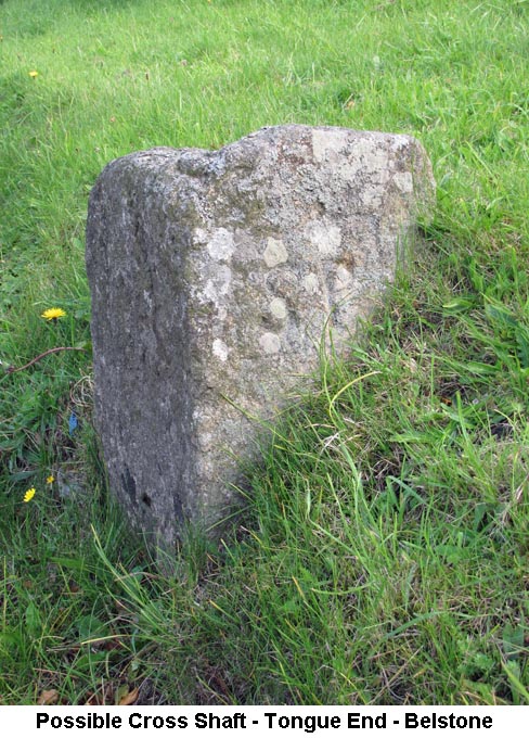
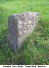 About
½ mile to the west of the Bude Lane Cross, there is a short length of
stone sitting on the grass verge on the southern side of the road at
Tongue End, Belstone (SX62327/94902). This is at the junction
where the road to Belstone branches off from the Okehampton to
Sticklepath road. It is thought that this might originally have
been the section of a cross which once stood near this spot. It
is well set in the ground and the top looks as though it has been
broken off at some point in the past. I have been unable to
obtain any clear evidence to confirm that it was originally a cross,
but it is recorded in the Devon
& Dartmoor Heritage Gateway (ref: MDV6903) website as a
possible cross shaft. In more recent years, the stone has been
adopted as a boundary stone for the parish of Sticklepath.
Although the community of Sticklepath has been in existence since at
least the 11th century, it was only granted parish status in its own
right in 1987. One face of the stone has been engraved with the
letters 'S P' (Sticklepath Parish) within a marked square but it can
be seen that this a modern addition to the stone, which probably
happened at some point shortly after 1987. About
½ mile to the west of the Bude Lane Cross, there is a short length of
stone sitting on the grass verge on the southern side of the road at
Tongue End, Belstone (SX62327/94902). This is at the junction
where the road to Belstone branches off from the Okehampton to
Sticklepath road. It is thought that this might originally have
been the section of a cross which once stood near this spot. It
is well set in the ground and the top looks as though it has been
broken off at some point in the past. I have been unable to
obtain any clear evidence to confirm that it was originally a cross,
but it is recorded in the Devon
& Dartmoor Heritage Gateway (ref: MDV6903) website as a
possible cross shaft. In more recent years, the stone has been
adopted as a boundary stone for the parish of Sticklepath.
Although the community of Sticklepath has been in existence since at
least the 11th century, it was only granted parish status in its own
right in 1987. One face of the stone has been engraved with the
letters 'S P' (Sticklepath Parish) within a marked square but it can
be seen that this a modern addition to the stone, which probably
happened at some point shortly after 1987.
|
|