Browse crosses
![]()
![]()
![]()

|
Browse crosses |
|
 Location:
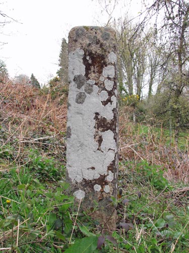
Towards the Western end of Sticklepath
Village, at the junction of the A30 with the narrow road that leads to the
hamlet of Skaigh. The cross is high up on the bank immediately on your
right hand side. Location:
Towards the Western end of Sticklepath
Village, at the junction of the A30 with the narrow road that leads to the
hamlet of Skaigh. The cross is high up on the bank immediately on your
right hand side.O/S Grid Ref: SX/63888/94135 Longitude/Latitude (Degrees+/-): -3.93000/50.73083 Map location: Click here to view map. Purpose: Venville Boundary Stone. Size: The stone is 4 feet 5 inches (1.35 metres) high, 15 inches (0.38 metres) wide at the bottom and tapering to 9 inches (0.23 metres) at the top. It is 12 inches (0.31 metres) in depth. The relief cross is 2 feet 5 inches (0.74 metres) high and 6½ inches (0.16 metres) across the arms. Information: This stone is thought to have been a boundary stone to mark the Venville Bounds of Belstone and Sampford Courtenay in a similar manner to the Sticklepath (Bude Lane) Cross, situated about half a mile to the north west of this stone. Although the markings on the stone are no longer very clear, they originally included a Latin Cross and two St. Andrew's Crosses. The stone is also of a very similar style to that of the Sourton Green Cross, on the village green below the Church. A large cross is shown in relief on the Western face of the stone and is rather unusual in proportion. The arms, at 14½ inches below the top, are about half way down the cross. There is also a round knob at the top of the cross. This gives it very much the appearance of, an out of proportion, sword. Harry Starkey described the cross in heraldic terms as a ‘Cross Pomel’. Alternatively, William Crossing described it as a Latin cross. In looking around the stone I was unable to detect any engravings on the other faces. There was, however, a hole in the top of the stone, which measures 2 inches in diameter and 1½ inches deep. I am unable to determine the reason for this hole. As with the other Venville Boundary Stone, at Bude Lane, research shows that there were other engravings on this stone, which have since weathered or faded away. The Eastern face is described as showing the following figures, from top to bottom: A semi-circle, St. Andrew’s Cross, cartouche-like figure, another St. Andrew’s Cross and two parallel waved lines, similar to a letter ‘S’. The semi-circle was open at the top and the cartouche-like figure resembles an egg timer. I have not come across anything recorded for the other faces. Another interesting point is that the 1874 description of the relief cross matches today’s description, except that it places it on the Northern face. However, Mr G.W. Ormerod wrote that the stone once fell down when it was undermined during the building of the new main road in 1829. It now would appear as though it has been turned through 90 degrees when re-sited to its current position. Presumably this would shift the above description of the markings on the Eastern face to the current Northern one.
The inscribed stone, although high up on the bank, is surrounded by a number of young trees. During my visit a friendly robin took up position in the trees and spent the whole time singing his tuneful song. At times he was so close to me that I felt I could have put my hand out and touched him. It was with great reluctance that I had to leave him and move on.
|